According to the law “On the State Real Estate Cadastre” adopted in 2008, a multi-contour land plot began to be understood as a territory that includes several separate plots at once, these usually include:
- Multiple circuits separated from each other;
- Plots of land with so-called holes or inclusions that will surround these territories along the entire perimeter.
This concept was developed to replace unified land use, which since 2008 is no longer used in legally significant documents.
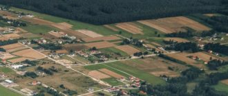
If we consider the sought-after point in practice, it turns out that such plots can be various kinds of private farmsteads or farms, where a vegetable garden or direct outbuildings are located from the main yard across the road, river, another person’s property, and so on. In general, a multi-circuit site implies the location of infrastructure on different lands.
It is worth noting that a multi-circuit land plot has only one cadastral number, so from a legal point of view, all operations will have to be carried out immediately with the entire multi-circuit plot.
This property is formed according to exactly the same principle as any other plot of land. There is only one key requirement for it - all the contours of a given site must be located within one locality , although it is quite possible that they will be located in different areas.
Formation of a land plot from several contours
As mentioned above, each of the contours of the boundaries of similar plots must be separated from the other contours by plots or lands owned by other owners. As a result, it turns out that multi-circuit areas do not have common points of contact along the boundaries.
The formation of such a site is carried out based on the first chapter of the Land Code, which spells out all the features of such a process.
According to this official document, the formation of a multi-circuit land plot can be carried out in one of the following ways:
- From lands owned by the state or municipality;
- From areas that were obtained in the process of allocation, redistribution or division.
It must be said that a multi-circuit section cannot form
to be in the process of combining two or more ordinary land plots (here we mean those that, as of today, are not multi-circuit). This is discussed in paragraph 6 of Article 11 of the Land Code, which states that only adjacent land plots are allowed to be merged, that is, those that have at least one common border. It turns out that areas that do not have such boundaries cannot be combined under current legislation.
At the same time, a multi-circuit section , which has already been registered with the state, can become a source of creating new sections. In particular, you can carry out land surveying and divide them into two or more parts, each of which can be used at your own discretion, in particular, you can perform various legal transactions with it - donate, sell, exchange, and so on.
What is a multi-circuit land plot?
The term “multi-circuit land plot” should be understood as a plot of land, which includes at least 2 separate parts that can be separated, for example, by a road.
The legislation distinguishes 2 types of such areas:
- Several parts (contours) of the earth that are divided among themselves.
- Allotments that have inclusions (so-called “holes” inside).
The law allows only one cadastre number to be assigned to a multi-circuit area.
Such plots were registered before the beginning of 2008, but then they were called “single land use”. Each part of such an allotment was assigned a separate cadastral number.
What does this term mean?
A multi-circuit land plot is a plot of land that has a border consisting of closed contours, fenced off from one another by two or more plots (contours).
The current concept was developed to replace the old one - “single land use” . After 2008, the use of this term in legally significant documents was suspended.
Thus, by installing a fence, we seem to inform other people that being in a specific territory is impossible without our consent or invitation.
If your territory has been entered without notice, you have the right to apply to the court or supervisory authorities in order to protect your legitimate property through legal means.
How do such areas form?
This property is formed in exactly the same way as any other land ownership. There is only one key requirement for it - all the contours of a given land must be located within one populated area , but the fact that they will be located in different areas is allowed.
Each property must be fenced off from the rest with the help of land. This must be done by the owners of the territory. As a result, it turns out that multi-circuit areas do not have common points of contact along the borders.
The formation of such a site is carried out in accordance with the first chapter of the Land Code , which describes all the general features of this process.
Based on the official document on the formation of a multi-circuit land plot, the process can be carried out in any of these ways:
- using lands owned by the state or municipality;
- through plots that were formed in the process of allocation, redistribution or division of land.
Note. Lands cannot be founded in the process of connecting more than two land holdings (only those that are not currently multi-circuit are meant).
If a multi-circuit plot is registered with the state, this fact may cause the creation of new lands. In particular, you can carry out land surveying and divide it into two or more parts, each of which can be used at your own discretion, and perform various legal transactions with it: sell, donate or make an exchange.
The legislative framework
To resolve various issues related to multi-circuit areas, you should use:
- Land Code. Particular attention should be paid to Chapter I.1, which describes the rules for the formation of these plots.
- Law “On the State Real Estate Cadastre” . This legislative document mentions the term “ multi-circuit land plot” for the first time, and also describes the process of assigning a cadastre number for such plots.
- Letter from the Ministry of Economic Development, drawn up on January 16, 2009. The text of the letter is devoted to the definition of the concept of “ multi-circuit land plot”, a description of the procedure for assigning a cadastre number and the formation of boundaries for these plots.
- Letter from the Ministry of Economic Development, drawn up on December 22, 2009. This letter describes how a cadastre number is assigned to such a site, as well as the procedure for obtaining information about any object of this type.
- Resolution of the Arbitration Court from the West Siberian District, adopted on February 2, 2015. This resolution talks about establishing boundaries on a land plot with several contours and explains that each part of such a plot must have a separate entrance.
- Resolution of the Arbitration Court of the Moscow District, adopted on January 28, 2015. According to this document, it is not allowed to assign a cadastre number to multi-circuit objects that have been seized.
When solving issues related to areas with several contours, we also recommend using scientific works with comments on codes and legislative acts.
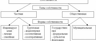
The concept of unified land use
The term single land use is used to designate an area of land divided into several plots (contours) by public buildings or territories, but owned by one owner.
It is necessary to distinguish between the terms single land use and actually single allotment. A single allotment is an area of land consisting of several territories that have either common borders or territorially demarcated parts. Each land contour is accounted for under an individual cadastral designation.
Accordingly, a single allotment should be called a collection of land plots that have a common property and are owned by one owner. Each part of the land area is characterized by separate geodetic parameters. In some cases, geodetic information of plots can be combined.
Plots with the legal status of single land use can be of 2 types:
- conditionally isolated;
- actually isolated.
The fundamental difference between conditionally isolated and actual areas lies in their location and the presence of common boundaries.
Often such plots are located close to neighboring plots that do not belong to the same land use. The plots, called conditional, are inherently adjacent. But there is a division between adjacent plots. In addition, they are defined by conventional boundaries.
The single land use regime is used for lands owned by horticultural cooperatives and associations. These plots are located isolated from each other, have individual designations in the cadastral registration of the state register, but they are included in the total mass of a single land use.
Previously, agricultural enterprises owned large areas of land, divided into separate parts (there were no adjacent demarcations).
Is it possible to do land surveying for free?
Where to find the urban zoning map, read here.
How to order an electronic extract from the USRN for a land plot, read the link:
Formation of a land plot from several contours
In practice, there are 2 options for forming sections with several contours:
- Formation from plots that are the property of a state body.
- Formation from plots that have been allocated, divided or redistributed.
The law does not allow areas that do not have adjacent boundaries to be combined into an allotment of several contours.
The decision to form a plot with several contours is made in cases where it is not possible to provide a citizen with the required area in the form of a single-circuit plot. For example, according to the law, a citizen who is a former member of a collective farm is entitled to a plot of 6 hectares. But since a plot of this area is not listed on the balance sheet, the law allows him to be given several plots of land so that the total area of the plot is 6 hectares.
How to allocate a share in kind
To highlight the share of a land plot in kind:
- First of all, secure the consent of the shareholders to the allocation. To check the seriousness of verbal agreement, you can first propose to conclude an agreement on the procedure for using the land.
- Conclude an agreement on the allocation and carry out cadastral work. It is necessary to invite a cadastral engineer to draw up one boundary plan for both plots - the modified one and the allocated one.
- When forming a site, do not forget to take into account the entrances and land management requirements that apply in your locality.
- Register your rights with Rosreestr and pay the shareholders money, if there was such an agreement.
- The allocated plot of land can be surrounded by a fence, the land can be sold, donated, a house can be built on it, or nothing can be done with it.
Boundary plan of a multi-circuit land plot
Without a boundary plan, you will not be able to assign a cadastre number to your multi-circuit plot. In addition, this document contains all the exact information about each part of the plot.
What documents are needed to purchase a plot of land, you will learn in this material:
The boundary plan contains 2 parts:
- Graphic, where you can familiarize yourself with the location of the site itself, as well as its boundaries.
- Text, which lists all the data that needs to be entered into the State Property Committee, as well as information about agreeing on the position of the boundaries of the allotment.
The boundary plan is usually drawn up in one copy in the case when:
- 1 plot was divided into several plots.
- Several sites have been redistributed.
- Several plots were formed by allocating a share from the common property.
- The allotment and its other parts were formed simultaneously.
- The formation of the site coincided with the clarification of data on other parts of the plots.
- At the same time, several plots of one multi-circuit area are formed.
- At the same time, data on the plots of the site, as well as the location of the boundaries of these plots, are clarified.
- Several new plots were formed, which led to clarification of data on the location of the boundaries of adjacent plots.
Anyone who is going to draw up a boundary plan is required to familiarize themselves with a sample of this document.
How to draw up an agreement on the allocation of land in kind
In such an agreement, it is necessary to determine the method and conditions of allocation. Since you also want to transfer your share in the residential building to the other owners, this will be a so-called mixed agreement. A possible full name of the document is an agreement on the allocation of land and donation of shares in the ownership of a residential building.
The agreement must contain the following clauses:
- Name, place and date of conclusion.
- A list of all participants in shared ownership, indicating full name, date and place of birth, gender, passport details, place of registration, SNILS.
- List of rights of all participants to the original plot and house: share in the right, basis documents, number and date of state registration of the right.
- In whose favor the land plot is allocated, its description and conditional number according to the boundary plan, an application for termination of the rights of common shared ownership of this person to the original land plot.
- Who will own and in what shares will the converted land plot be owned?
- To whom and in what shares is the share in the right to the house of the initiator of the land allocation given?
- Application by the initiator of the allocation of a land plot to terminate his right of shared ownership of the house.
- Information on the distribution of expenses for state duties, cadastral work, transaction, etc.
- Moment of entry into force of the agreement.
- Other obligations of the parties, for example the date of submission to Rosreestr,
- Signatures of the parties.
The sequence of actions will be as follows:
Sample
sample boundary plan in MS Word format.
The boundary plan usually contains:
- Title page.
- Content.
- Text part.
- Graphic part. Its content includes diagrams of the position of each plot and geodetic constructions. In this part you can also find drawings of land plots and outlines of nodal points for all plot boundaries with several contours.
- Applications.
If a multi-circuit plot was formed using the usual combination of several plots, the boundary plan will contain:
- Initial information.
- Information about the formed plots and their parts.
- Information about the plots through which access to the formed or converted plots is provided.
When a site with several contours was formed by allotment, division or redistribution of plots of land, the boundary plan will contain:
- Information about the formed areas and their parts.
- Information about the areas through which access to formed or converted plots of land is provided.
If a plan is created for a multi-circuit plot formed by dividing one plot, information about the converted plots or their parts must be added to this document.
In the case when you are going to draw up a boundary plan due to clarification of the area of plots or the location of boundaries, the document will contain information containing clarifying information about the land plots or parts thereof.
If a boundary plan is created only in order to assign a cadastre number to the formed plots of land, information about the formed parts of the plot is added to the contents of the document.
The document contains an official conclusion drawn up by a cadastral engineer if inconsistencies were found in the location of plot boundaries or objections were recorded regarding the location of the plot allocated as a share of the common right of ownership.
In what cases is land surveying necessary?
There is a whole list of cases when land surveying becomes necessary. We list the main ones:
— it is necessary to register ownership of the land plot;
— the owner of the land is going to divide the land plot for sale or transfer it by inheritance;
— disagreements have arisen between neighbors regarding the boundaries of their plots (Russian courts annually consider thousands of cases on the so-called neighbor wars);
— it is planned to divide the land plot into two or more independent plots;
Clarification of a multi-circuit land plot
It is necessary to clarify the boundaries and/or multi-contour allotment in the following cases:
- If the area or location of the plot does not correspond to the data specified in the cadastral authority database.
- When the cadastral authority’s database completely lacks information about the site.
- If the boundaries of the site intersect.
The following may be involved in clarifying data about the site:
- Its owners.
- Landowners.
- Persons who have the right to perpetual use of the allotment.
- Persons who have a notarized power of attorney to clarify the boundaries and/or area of the site.
It is possible to clarify the boundaries and area of a multi-circuit area if you have:
- Certificates of ownership.
- The decision to transfer the land into ownership.
- Another document with which you can confirm ownership.
The clarification procedure involves performing the following actions:
- Studying documents that confirm the right to own a plot with several contours:
- Check documents for grammatical or grammatical errors.
- Check whether the address reference needs to be clarified.
- Determine whether the type of permitted use needs to be changed or assigned.
- Carry out geodetic measurements, taking into account the location of the fence and other objects that help determine the correct location of the boundaries of the multi-circuit area.
- Drawing up an act of approval of boundaries, where the signatures of the owners or owners of adjacent plots must be affixed.
- Drawing up a boundary plan by a cadastral engineer.
- Submitting the boundary plan to the cadastral registration service for verification.
- Issuance of a cadastral passport or extract.
The clarification procedure will be simplified if a similar procedure was carried out by at least 1 owner or owner of a neighboring plot.
How to correctly draw up an act of approval of the boundaries of a land plot, read this article:
With whom will you need to coordinate the boundaries of the site?
Coordination is necessary with persons who own adjacent plots of land.
If the land plots are in state (municipal) ownership, then the location of the boundaries must be discussed with the persons who own these plots on the right of lifelong inheritable ownership or permanent (indefinite) use. In this case, coordination with institutions, state-owned enterprises, state authorities and local governments is not required.
If the adjacent plot is in state (municipal) ownership and provided under a lease agreement for a period of more than 5 years, then the boundaries must be agreed upon with both the owner and the tenant.
Section of multi-circuit land plots
After the division of multi-circuit plots, new areas:
- Will not be considered adjacent plots.
- May be located in different neighborhoods.
For the division of a multi-circuit allotment the following is presented:
- An application from the owner, certified by a notary, for the division of the plot.
- A copy of the document certified by a notary, which confirms the right to own the land.
- Passport or other identification document.
- Consent of other owners to the division (such a document is not needed when the division is carried out by court decision).
- The decision on the assignment of addresses for the divided parts, which is made by the local authority.
- A power of attorney certified by a notary, if authorized persons participate in the procedure.
- Receipt of payment for state registration.
A multi-circuit plot can be divided if:
- After the procedure, the purpose of each new area will not change.
- The area of each new plot will not be less than the approved minimum sizes of land plots.
- Each new site will have an entrance.
- It is not intended for farming.
The division procedure is carried out in the following stages:
- Land management work is carried out - surveying, coordination of boundaries and registration of land management documents.
- Appeal to Rosnedvizhimost, where each owner of a new plot must register the land plot.
If buildings or structures are located on a new plot of land, only the owner of the real estate can be its owner.