Many people understand land management as a voluntary process of land surveying (read our article about what land surveying is and how much it costs), but these are far from synonymous. Obligatory land management is regulated by law, so let's figure out in what cases and when land management is carried out mandatory.
Land management is... Concept
There are several definitions of land management: legislative and scientific. The law states that land management is a whole series of procedures and actions aimed at the rational use, protection and study of the condition of land. This also includes work to describe the location and establish boundaries (land surveying) of land management objects (state and municipal boundaries, or parts thereof). From the point of view of scientists, land management is the science of studying the appropriate use of land and its protection to solve the production and economic problems of society. For these purposes, modern information technologies, applied economic research, and economic, mathematical and statistical methods are used. In our opinion, for a more accurate understanding of such a voluminous process as land management, it is better to consider the versions of the two communities comprehensively.
Land management - measures to study the condition of land, plan and organize the rational use of land and their protection, describe the location and (or) establish the boundaries of land management objects on the ground, organize the rational use of land plots by citizens and legal entities for agricultural production, as well as the organization of territories , used by communities of indigenous peoples of the North, Siberia and the Far East of the Russian Federation and persons belonging to the indigenous peoples of the North, Siberia and the Far East of the Russian Federation, to ensure their traditional way of life (on-farm land management).
Why is land management needed?
Land management work (land management) is carried out to establish, restore and consolidate the boundaries of land ownership and land use on the ground, as well as to determine the actual area and location of the boundaries of a land plot on the ground.
Land management involves conducting cadastral surveys, aerial surveys, topographic-geodetic, soil, geobotanical and other surveys and measurements, boundary surveying, and the development of proposals for the rational use of land, which allow collecting data on the quantitative and qualitative parameters of land plots in the state territories. To ensure the reliability and reliability of data, a certain procedure has been introduced for certification of measuring and technical means that are used to survey and measure plots of land for the purposes of land management on the basis of technical and technological standards. Based on the survey, land management documentation is compiled, which includes diagrams and plans of land plots, as well as cartographic and other materials of land management projects. For each land management object, a land management file is compiled from land management documentation.
The main document of the land management process, which is accepted by cadastral registration authorities and is one of the grounds for registering a land plot with cadastral registration, has long been land management.
Since 2008, the concept of “Land Management” has been replaced by “Land Survey Plan”.
Information regarding the area of a plot of land, the location of various types of objects and buildings, as well as engineering systems and natural objects is contained directly in the plan of land plots. Such plans additionally include information about the restrictions and encumbrances of the land plot, including indications of those parts of the land plot on which the easement right applies. A land plot plan is necessary when buying and selling land plots and making other land transactions.
Land management is one of the stages of state cadastral registration of land plots. When privatization, registration and re-registration of land ownership rights, sale, lease, donation, exchange and other types of transactions, land surveying work is required. When registering rights to a land plot, geodetic work is the first stage, because on their basis, a cadastral passport of the land plot (cadastral plan) is prepared.
Speaking about the land system, the task of land management is to create rational use and protection of land in each sector of the economy, as well as to bring the organization of territory and production into line with existing land relations. With the help of land management, optimal conditions for the effective use of land are established and the problems of organizing land use are solved. Since the effectiveness of land management is in the sphere of social production, land management should serve as the main lever of the state in the process of implementing land transformations, and must also be of a state nature. At the same time, other functions of land management can be distinguished, namely: sectoral; territorial; on-farm.
Land management is divided into two types: - territorial; — on-farm.
When carrying out territorial land management, the boundaries of land plots on the ground are established and agreed upon, and the actual area of the site is calculated. The boundary plan obtained as a result of territorial land management is sent to the Rosreestr authorities for approval and inclusion in the Unified State Register of Lands.
On-farm land management implies the organization of rational land use within the already allocated land plots for agricultural activities. Its actual purpose is to review and approve plans for the placement of agricultural land, pastures, residential and industrial development facilities, as well as engineering and transport infrastructure within such land plots. This type of land management is usually carried out at the request of entities that have rights to land plots.
What does the concept of “land management” mean?
Article 113 of the Land Code gives a clear concept of land management:
— development of forecasts, republican and regional programs, schemes for the use and protection of land resources and land management schemes;
— establishment of boundaries of administrative-territorial entities on the ground;
— drawing up projects for the formation of new and streamlining existing land tenures and land uses with the elimination of inconveniences in the location of land, allotment of land plots in kind, preparation of documents certifying the right to own and use land;
— development of on-farm land management projects and other projects related to the use and protection of land;
— development of working projects for the reclamation of disturbed lands, protection of soils from erosion, mudflows, landslides, flooding and salinization, improvement of agricultural land, development of new lands;
— justification for the location and establishment of boundaries of territories with special environmental, recreational and reserve regimes;
— establishment and change of city limits, village limits and rural settlements;
— carrying out topographic-geodetic, cartographic, soil, agrochemical, geobotanical and other survey and survey work.
It should be noted that when implementing on-farm land management activities, the interests of all participants in the land management process must be ensured.
Which authorities carry out land management
On-farm land management can be carried out by territorial bodies and specially authorized institutions with the participation of municipalities. According to the federal law of October 6, 2003 N 131-FZ “On the general principles of organizing local self-government in the Russian Federation,” rural, township, and district administrations plan the use of lands that are located within the boundaries of the relevant municipalities, monitor their use and protection.
Land management work includes the development of general plans and city development plans, planning for the development of urban areas, rural districts, zoning schemes for the protection of territories and settlements from the effects of natural and man-made emergencies, protection zones around specially protected objects, zones of influence of industrial enterprises. When reorganizing certain objects, land management companies conduct an inventory of land, delimit part of the land transferred into common ownership, clarify the boundaries of land for which restrictions on use have been established and which are burdened with the rights of other entities. Based on the provisions on land management, the maximum dimensions and requirements for the position of land are determined.
Land management is carried out by decision of government authorities. The basis for this are contracts concluded by interested parties and land management companies.
Subjects whose legitimate interests may be affected during land management are notified of this by land managers in writing. Based on the results of zoning, a map of the territory is drawn up, which includes data on the location, area and intended purpose of the land, permitted use of the land, including instructions on restrictions, encumbrances and easements. This scheme is the basis for resolving issues related to the construction of access roads, communications facilities, as well as for the development of public transport, trade and other infrastructure.
Based on the results of land management, land management documentation is formed. There are several types of land management documentation: a land management scheme for the territories of constituent entities of the Russian Federation, a general land management scheme for the territory of the Russian Federation, a scheme for the protection and use of land, a land management scheme for municipalities; plan (map) of the land management facility; on-farm land management project; projects for the development of new lands, improvement of agricultural land, reclamation of disturbed lands, protection of lands from mudflows, erosion, waterlogging, flooding, drying out, secondary salinization, compaction, pollution by consumer and industrial waste, chemical and radioactive substances, contamination and other negative impacts; materials of geobotanical, soil and other surveys and surveys, assessment of land inventory, land quality; thematic atlases and maps of land use and condition. Federal laws and other regulatory legal acts of the Russian Federation, as well as laws and other regulatory legal acts of the constituent entities of the Russian Federation, can establish other types of land management documentation. Subsequently, the prepared and approved land management documentation is used to register the right to a specific land plot with the receipt of documents establishing ownership. So, land management is a specially designed system of measures that promotes the rational organization, use, and protection of land. Land management is also responsible for creating the necessary favorable ecological environment and preserving, as well as improving existing natural landscapes.
Who carries out land management
Since the objects of land management are state-owned lands, the state is responsible for carrying out land management. It determines the procedure for land management, coordinates the activities of authorized executive authorities, adopts relevant legislative acts, and carries out state activities. supervision, develops and implements specialized cartographic material, and, of course, carries out land management itself. At the same time, the law does not prohibit legal entities and individual entrepreneurs from carrying out land management work (you can read about land management as a direction and profession here).
Who is the subject of land management?
It is worth noting that a very wide range of people carry out land management processes. Today the subjects of land management are:
- Russia and its subjects, which are represented by government bodies,
- Local government bodies acting as municipal entities
- All individuals
- All legal entities, which include institutions, organizations and enterprises.
There are also special subjects of land management processes, which include communities of indigenous peoples of distant regions, and in addition to them, also persons related to these communities.
Carrying out land management, what work is carried out as part of land management
Let's figure out what types of work are carried out as part of land management. First of all, the condition of the land is studied on the basis of geodetic, cartographic work, field surveys and surveys (soil, geobotanical, etc.). After that, on the basis of the collected data, an assessment of the properties and characteristics of the lands is carried out, as well as their inventory, through which unused lands or those used for other purposes are identified. As soon as such territories are identified, regardless of the form of ownership, work is carried out to organize the expedient use and improvement of such lands and agricultural lands (on-farm land management). If necessary, land surveying of land management objects is carried out. The above types of work are strictly regulated by current legislation and other recommendations for land management, local orders, etc.
Cases when land management is mandatory
Although the process of land management in the country is ongoing, it is worth highlighting cases when land management is carried out without fail:
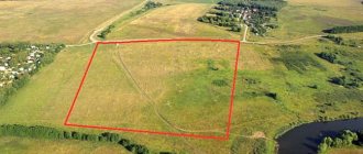
In cases of establishing or changing the boundaries of land management objects
In cases where the borders of constituent entities of the Russian Federation, municipalities, individual settlements or parts thereof undergo certain changes (formed, adjusted or cease to exist). Since such activities are not carried out only “cartometrically”, work to change the boundaries of land management objects is carried out taking into account a whole string of materials, a set of factors and laws: urban planning, forest management, cadastral, geodetic and other documentation; geophysical, climatic, historical features of the territory, local traditions, etc.
In cases of land protection
In case of detection of disturbed lands, susceptible to erosion, waterlogging or, conversely, drying up of lands, their contamination (various wastes, radioactive or chemical substances, etc.), work is carried out to restore or conserve such lands, their reclamation (restoration of fertility) and protection. Taking into account the ubiquity of such negative processes and, accordingly, work to prevent them and eliminate the consequences of their manifestation, it is not difficult to imagine the scale of land management work on the territory of our country.
What types of land development exist?
Land structure is divided into on-farm and territorial.
The last type of land management is a set of works that are aimed at studying the state of land funds, determining administrative and territorial boundaries, organizing their proper use, and also determining land surveys.
The reasons why it is worth carrying out this type of land arrangement are:
- When allocating land shares,
- The boundaries of the site are changing
- Creation of territories that will be protected. For example, gardens, parks, etc.
- Disturbed lands were discovered,
- When carrying out reclamation and conservation of land,
- Creation of zones where a special land use regime will apply,
- Changing, as well as establishing the boundaries of settlements and their zoning,
- Location of enterprises,
- When areas allocated for agricultural activities are withdrawn or, conversely, provided.
- Location of enterprises.
The first type of land management is a set of measures aimed at organizing the rational use of land resources within the boundaries of certain land plots that were allocated for agricultural activities.
On-farm land management is actually intended to study and approve plans for the placement of land, industrial and residential buildings, pastures, and in addition, structures related to engineering and transport infrastructure within the boundaries of a specific site. Often this type is organized when it is required by the entity that has the rights to the land plot.
On what basis is land management carried out?
It is clear that in order to carry out a complex of land management work, a foundation is needed. Since land management is the area of responsibility of the state, the grounds for its implementation may be the following:
- decision of authorities;
- the court's decision.
At the same time, the initiative can come not only from executive authorities, but also from land owners and land users, therefore, an agreement on land management can also be the basis for its implementation.
Land management practice
The practice of land management work is large and diverse. This science includes a huge layer of areas: geodesy, cartography, legal regulation of land and property relations, land surveying, real estate cadastre, geographic information systems, etc. It is difficult to imagine what state our country’s land resources would be in without this fundamental science. At the same time, citizens should not neglect their consciousness; the country is large and the state cannot see to everything. Remember that along with the land, you acquire great responsibility. Take care of the condition in which the land resources of our country will be transferred to future generations.
What is land management?
There are several legislative acts in force on the territory of the Russian Federation, namely, the Land Code of the Russian Federation and the Federal Law “On Land Management,” which clearly define this concept. In accordance with them, land management is measures for the protection, study, organization and planning of rational exploitation of existing land resources by legal entities. persons and citizens of the country. They are aimed at organizing existing areas and forming new ones, establishing their boundaries on the ground. In addition, as part of these activities, planning is carried out for the areas of Russia where indigenous peoples of the Far East, Siberia, and the North live.
It is useful for everyone to know about the possible consequences of illegal connection to the power grid.