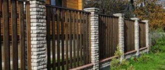
What to do if boundary boundaries are violated with a plot belonging to a neighbor?
The land grab situation is quite popular. The land plots are located in the neighborhood, and there is a fence on the border of the territory. To privatize a plot, land surveying is carried out and a cadastral plan is drawn up. When carrying out a survey, a cadastral engineer identifies a violation of boundaries.
In theory, fixing the situation is simple. It is enough to move the fence to the boundary indicated by the engineer. In practice, disputes over property boundaries are one of the most popular conflicts between neighbors.
If a neighbor refuses to move the fence voluntarily, then you must act as follows:
- Prepare documents.
- Send a complaint to your neighbor.
- Go to court (if the neighbor refuses to comply with the requirement specified in the complaint).
Let's take a closer look at the procedure.
Cost of challenging land survey
In order to invalidate a neighbor’s land survey, you will need to clarify the boundaries of your plot (10,000 rubles; 14 days) or map out the coordinates of turning points (2,000 rubles for one point; 2-3 days). After this, draw up and submit a statement of claim (10,000 rubles) and a petition for an examination (5,000 rubles). Carrying out the examination - 35,000 rubles, will be completed in 14 days. We represent the client in court (RUB 35,000).
To independently assess the situation, we carry out:
- Expertise in land surveying of country and garden plots;
- Correction of cadastral and registry errors;
- Re-clarification of boundaries.
Lawyers will help eliminate discrepancies and prove the accuracy of the coordinates, representing the interests of customers in all instances.
Changes are registered and entered into the cadastral register. Our price list
Pre-trial
The procedure for pre-trial settlement differs from a regular request in that the victim prepares a complete list of evidence. A claim is drawn up based on the documents. In it, the victim warns the culprit that if he refuses, he will go to court.
To prove that you are right, you need to accurately mark the boundaries of the site. This can only be done by a cadastral engineer. The boundaries of the site are established by placing points on the terrain. The engineer takes measurements and indicates the exact boundaries of the site. The measurement error cannot exceed 10 cm.
As a result of the work, the engineer draws up an act of placing points on the ground. It is drawn up in 2 copies and signed by the customer and the contractor. The act is one of the main pieces of evidence in a dispute with a neighbor.
It should not be confused with land surveying. When surveying, the actual boundaries of the site are transferred to paper. And when points are taken out into the area, the boundaries from the cadastre are marked on the ground. As a result of the removal, it becomes clear which territory is captured.
Other documents for the claim:
- civil passport of the owner of the plot;
- extract from the Unified State Register for the site;
- document of title (sale and purchase agreement, exchange, donation, privatization, certificate of inheritance rights);
- cadastral passport;
- the act of placing points on the ground.
Additionally, you can attach photos and videos of the fence and points of the actual boundaries of the end of the site.
Sample claim and submission procedure
The claim must be made in writing. It must indicate:
- details of the offender;
- information about the victim + phone number;
- Title of the document;
- information about rights to the site;
- data about the violation;
- reference to law;
- a request to eliminate violations and install a fence in a straight line on the border of an adjacent land plot;
- deadline for elimination;
- notification of recourse to court in case of refusal of voluntary execution.
Sample claim
An example from judicial practice
In 2021, the Krasnoozersky District Court heard a case about establishing the boundaries of the land plot and demolishing buildings.
A dispute arose between the owners of adjacent plots. Plaintiff A. carried out land surveying, but defendant B. did not agree with the results and refused to move the fence and demolish the outbuildings. buildings, since its documents indicate completely different boundaries. The parties were unable to reach an agreement on their own.
In refutation of the plaintiff's claims, the defendant stated that the plaintiff seized part of her territory and erected a hothouse and a bathhouse, attaching it to the wall of her building. In winter, snow from the buildings melted into the defendant’s yard, making it impossible to organize walks for my daughter with limited mobility (disabled). A counterclaim was also filed.
The court refused to satisfy the claim, but decided to satisfy B.’s demands and ordered A. to demolish the buildings within a month, and also to collect 5,160 rubles from A. towards reimbursement of legal expenses.
The reason for this decision was that B. acquired ownership of the plot much earlier than A. It was also established that B. carried out the land surveying procedure in accordance with the requirements of the law, and the coordinates of the plot were determined.
What is shared ownership?
Shared ownership means that an object (house, apartment, plot) has several owners at once. At the same time, the size of each person’s share in the common property is strictly fixed. An entire chapter of the Civil Code is devoted to the concept of common ownership. According to the document, the presence of two or more owners makes the property common (Article 244 of the Civil Code of the Russian Federation). It can be of two types:
- without allocation of shares (joint);
- with determination of the share of each owner (shared ownership).
The sizes of shares may vary: both equal parts and any other ratios are acceptable.
Basic principles for using a plot of land in shared ownership:
- each of the owners receives for use a part of the land plot in proportion to the allocated share (Article 247 of the Civil Code of the Russian Federation);
- At the same time, all other property located on its territory is distributed: plants, grown fruits, etc. (Article 248 of the Civil Code of the Russian Federation);
- expenses for maintaining real estate are also divided among all participants, in accordance with the size of their shares (Article 249 of the Civil Code of the Russian Federation);
- each owner has the right to dispose of his share at his personal discretion: it can be sold, given as a gift, etc. (this can only be done after obtaining the permission of all other owners of the site - by law they have a pre-emptive right to purchase the alienated share) (Article 246 of the Civil Code RF).
Important! A plot of land that is in shared ownership is assigned one cadastral number. At the same time, the USRN extract separately records the share of each participant in the joint ownership. If desired, the share can be separated into an independent object. It will be registered under a separate cadastral number (Article 252 of the Civil Code of the Russian Federation).
On our website you will find other publications on the topic of using land, from which you can learn:
- What is the procedure and grounds for granting land?
- Where to apply for the allocation of a site and what to do if the administration refuses?
- Who is entitled to benefits?
- How does loss of use rights occur?
- What is preliminary approval and how does it happen?
- How to file a claim to remove obstacles to the use of a land plot?
Is it possible to build a house on the boundary
Building a house is a long and difficult process; it must be approached seriously and carefully. It is necessary to determine in advance the location of the future house on the site, while meeting all urban planning standards, and only then determine its layout and work out the external component.
It should be remembered that all your wishes when building a house should not contradict the provisions of the law, since otherwise you will be held accountable for violations.
Important! The construction of houses is often associated with various types of errors. A typical mistake is the location of the building in unacceptable proximity to the fence. This situation usually occurs due to incorrect calculations.
To prevent such a violation, careful calculations must be made. In particular, the distance from the house to the fence should not be less than three meters.
At the initial stages of construction, if there is no fence, you may think that this distance is too large, but later you will be convinced that it is the most optimal.
Important! The distance between the boundary and the house is measured from the protruding parts of the building - these are the porch, veranda, etc.
Land tax benefits for pensioners
How to assign an address to a land plot, read here.
What document is issued after land surveying, read the link: https://novocom.org/nedvizhimoe-imushhestvo/zemlya/kakoj-dokument-vydaetsya-posle-mezhevaniya-zemelnogo-uchastka.html
How to resist the neighbors who started this
Whatever the emotions, any actions in such cases must be consistent with the Law.
Namely, by acting within the limits of what is permitted, you can achieve the final result you require in the confrontation with your boorish neighbors. Many people associate the word “Law” with the word “bureaucracy,” but this is not so. Judicial practice in cases of flooding of land is quite rich; a clear algorithm for making decisions in favor of the injured party has already been developed. Before writing a statement of claim, you need to obtain two documents - an act on the fact of flooding of the site and a report on an independent assessment of the damage. The certificate of flooding of a land plot is authorized to be issued by: the village administration, the board of the dacha cooperative, the district commissioner and other government representatives in the locality. That is, this document is needed so that the court can see that flooding took place. This act is similar to a certificate of road accident, which is drawn up by the State Traffic Safety Inspectorate in the event of an accident, or a report of flooding of an apartment, which is issued by the DEZ in case of flooding of the premises.
An independent assessment of the damage caused to the land plot is needed to determine the cost of restoring the property to its original condition. As in the two above cases, an expert opinion on damage to a land plot is required to justify the cost of the claim to the court. A document expressing exactly the monetary amount of damage is prepared by an independent appraiser, who should be called to measure and photograph the extent of flooding of the summer cottage. The same damage assessment report is made when a neighbor has unauthorizedly moved a fence, dumped construction debris, broken a gate or broken trees.
How much does it cost to assess damage to a land plot?
The cost of the appraiser’s services depends on the specifics of the damage caused and is individual in nature. We cannot attach a table of prices to this article, as is the case with assessing damage after an apartment was flooded or as with assessing land as a single piece of suburban real estate. As a rule, the cost of damage assessment services on a site varies from 4,000 to 10,000 rubles. The exact cost of the services of an independent damage assessor depends on the specifics of the damage.
Damage can be caused not only to structures, but also specifically to the personal plot where these objects are located. Often there is a disrespectful attitude from neighbors in the area. Due to the irresponsible actions of neighbors or construction organizations, the land plot turns into a swamp or landfill, and a residential building, outbuildings, trees, shrubs, and planted plants are damaged.