Would you like to consult a lawyer for free? Write to the chat on the bottom right or call the hotline, calls within the Russian Federation are free. We accept questions any day of the week.
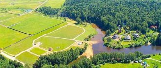
The question of why land surveying is needed in 2022 sounds very relevant and is of interest to many land users. The answer to this is provided by Russian legislation and regulations. In some cases, such an event is mandatory, and sometimes you can do without it. Land surveying deserves special attention.
The legislative framework
The main laws on land surveying are the Land Code of the Russian Federation (LK RF), adopted in 2001, and the Federal Law (FL) of June 18, 2001 No. 78-FZ “On Land Management”. They define the meaning of land surveying and its purpose.
Article 22 of Law No. 78-FZ provides for the formation of a land survey file, which must be stored in the state archive.
The procedure and rules for determining boundaries are regulated by subsequent legislative acts, which are periodically clarified and supplemented. They are defined by the following documents (with the latest changes):
- Federal Law of July 13, 2015 No. 218-FZ. It establishes the features of cadastral registration and rules for registering real estate. The title document for the land is determined by an extract from the Unified State Register of Real Estate. According to Art. 14 of the Law, the boundary plan and the final act are defined as the basis for registration of property rights.
- Federal Law of July 24, 2007 No. 221-FZ “On Cadastral Activities”. It regulates the work of cadastral services.
- Federal Law No. 447-FZ dated December 22, 2014 defines the tasks of a cadastral engineer when conducting land surveying. It is clarified why it needs to be done and the need for certain procedures. Mandatory deadlines for land surveying are established.
- The Roskomzem instruction dated April 8, 1996 establishes the composition of land management documents and the information that should be contained in them, and the methods for carrying out the activity.
- Methodological recommendations of Roszemkadastre dated February 17, 2003. They clarify the procedure for carrying out land surveying works.
Important! These documents fully define the goals, objectives, conditions and procedure for conducting land surveying in 2022.
Why do you need to define boundaries?
There is no need to demarcate the area if you have managed without it before. There need to be compelling reasons to implement boundary-defining activities.
Possible problems
If surveying is not carried out, the following troubles are possible :
- disputes with neighbors about boundaries;
- it is possible, by court decision, to demolish buildings that stand on a neighboring plot;
- the inability to determine the construction site of any object that must be located at a certain distance from the border;
- inability to sell the plot at a better price;
- the impossibility of combining sections into one or making cuts.
All these problems can be solved by calling a cadastral engineer.
How are disputes resolved?
Disputes with neighbors can be resolved in two ways: peacefully or through the courts .
The second method involves legal fees and costs for a lawyer, but does not guarantee benefits.
Therefore, it is better to agree on boundaries.
This step is registered in an approval act, which is signed by the initiator of the procedure, the owners of neighboring plots and the cadastral engineer.
In what cases is the procedure needed?
Land surveying has the following legal meanings:
- the boundaries of allocated plots of land from the state fund are determined;
- the boundaries of the existing land plot on the ground are restored;
- the boundaries of the plots are agreed upon and regulated.
In other words, work is necessary to establish the boundaries of the land plot. The data obtained allows us to draw up an accurate cadastral plan. It ensures land records, determines the boundaries of property rights, and helps resolve all disputes between the owner and neighbors.
Important! The need for land surveying is established by law. In some cases it is mandatory.
Read more about how land surveying is carried out here.
Land transactions
Amendments to Law No. 447-FZ, which entered into force in 2021, prohibit any transactions with land plots that have not undergone the survey procedure. However, the existence of property rights to them does not negate the need to define boundaries.
Until 2008, it was possible to register an unlandmarked plot, but now in order to complete any transaction (purchase and sale, donation, etc.) land surveying will have to be carried out. Transfer of ownership rights can only be carried out after the exact boundaries of the site have been established.
Changing site characteristics
In some cases, the characteristics of land plots change. This can happen when one large plot is divided into several small ones with different owners or, conversely, when land plots are combined.
Re-issuance of new documents will be required, incl. cadastral passport, legal documents, which requires land surveying procedures with the establishment of new boundaries for the site.
Increase in land area
Expansion of a land plot at the expense of ownerless land (which is not anyone’s property) is permitted by the Land Code of the Russian Federation. However, such a procedure must be carried out legally. You can’t just pick up and move your fence. New information about the area must be entered into the Rosreestr database.
To do this, it is necessary to establish new boundaries by carrying out land surveying, change the cadastral plan, and draw up all the necessary documents.
Construction of a capital construction project
To erect a permanent structure on your own site, you will need a building permit or notification of the construction's compliance with established standards from local authorities. To obtain them, you need a construction project referenced on the ground, where the established distances and offsets are observed. Without establishing the exact boundaries of the site, it is impossible to assess compliance with the standards, which means that a boundary plan must be drawn up.
Restoring or clarifying boundaries
Problems often arise when using land with a long history. It could repeatedly pass from one owner to another. Often, some documents are lost, the fence is arbitrarily moved. During previous surveying, mistakes could have been made.
As a result, the existing boundary plan does not correspond to reality or is completely lost. This leads to problems with neighbors and tax authorities.
To resolve them, it is necessary to clarify the boundaries or restore them in case of illegal violation. This can only be done by carrying out a new survey.
Separation of an allotment from collective property
If the shareholder decides to leave the common, collective property, then, first of all, he must clearly define the boundaries of his land plot. This requires a procedure for geodetic division of boundaries. It must be agreed upon with other shareholders, and the boundary plan is reviewed and approved by the general meeting.
A user of a land plot can establish the boundaries of his plot without leaving the collective property. The exact boundaries of the plot will be established on the boundary plan, which clarifies the size of its share.
Registration of land ownership
Title documents for land can be drawn up only when the exact boundaries of the land plot are established. The boundary plan is a mandatory document for registering property rights. Consequently, registration of land ownership is impossible without defining boundaries.
Controversy
The emergence of disputed boundaries between neighboring areas is recorded quite often. The dispute is resolved simply if the participants have boundary plans that are registered in Rosreestr. The documents will determine the exact boundary and fix the problem.
It is more difficult when Rosreestr cannot resolve the dispute, and land owners file an application in court. In this case, the judge initiates the land surveying procedure, and a decision is made based on its results.
Timing and cost
How is land surveying carried out, namely, how long does the process of determining boundaries take? In practice, specialists complete all the work and prepare a boundary plan in approximately 2 weeks.
But since neighbors must be informed about the procedure no later than a month in advance, land surveying takes 1.5 months. But if for some reason you need to make corrections to the documents, this period may increase.
As for the cost, much depends on which organization will carry out the land surveying. Government agencies usually set prices based on specialist salaries.
And private organizations have the right to use other reasons to set the cost of work. Usually, “private owners” are more expensive, but then you won’t have to wait your turn, which happens when you contact the cadastral engineers of Rosreestr.
The cost can be set for the entire surveying procedure or for each type of work separately. For example, the standard procedure for a plot of up to 0.5 hectares will cost 6 thousand rubles, and for a plot of up to 1 hectare - 12 thousand rubles. In the capital and region these prices may be slightly higher.
Whether it is possible to carry out the land surveying procedure for free, find out from this material.
So, we’ve talked about the price, and then we’ll look at the procedure for marking the boundaries of a land plot.
In what cases is land surveying not necessary?
In certain situations, the owner may not carry out land surveying. The law establishes only the above mandatory circumstances. In all other cases, the owner can carry out such a procedure voluntarily when he wants to know the exact boundaries of the property to plan his actions.
Mass development
Massive construction of capital structures according to a master plan is sometimes carried out over a large area. In this case, the developer himself will coordinate all the documents with local authorities, and the owners of the land plot are not required to have a boundary plan.
However, in reality, the boundary plan of even one site creates problems for the district architect, and there is a risk that a particular building may disappear from the plan. If the land owner is still interested in construction, then it is better for him to carry out the survey voluntarily.
Territory cutting
Owners of land plots often develop nearby abandoned land and engage in agricultural work on it. If such use is temporary and the owner does not seek to expand his holdings, then land surveying is not required. Most likely, no one will make claims against him until someone wants to officially receive this land.
If you plan to expand the site, you will have to carry out land surveying work and draw up the necessary documents. To ensure mass development, local authorities can organize a free survey procedure.
Inherited land
When transferring by inheritance a land plot for which a boundary plan has been drawn up, a new survey is not required. Ownership rights are transferred upon presentation of an existing document.
Another situation arises when several heirs take ownership of the land. In this case, it becomes necessary to carry out land surveying with division of the plot in accordance with the inherited share.
It is important to understand that the law does not require land surveying to be carried out with a cadastral engineer. The heirs can simply agree among themselves on the rules for using the land. Official delimitation is necessary if any actions are planned on the part of individual heirs.
How to do it from a satellite
Speaking about satellite surveying, it is worth saying that this is a complex of engineering and geodetic orientation. This activity is necessary to formalize, establish, and secure the boundaries of the territory. This process uses satellite technology. In the case under consideration, the boundary can be real, and it is also possible to describe it using special coordinates.
The procedure is not mandatory in all cases, but it may be necessary. An example is the sale of an allotment through sale, when the buyer may doubt the correctness of the boundaries. This is due to the fact that a person does not want controversial issues to arise with persons whose plots are located next door.
The type of survey under consideration is the most accurate, which is associated with the use of precise satellite equipment.
The process is carried out through the following steps:
- Initially, the coordinates of the points are set using receivers;
- determination of turning points, then they are fixed on the ground;
- based on the data that was received, the area is calculated;
- the features of the allotment are subject to agreement;
- boundary documentation is drawn up;
- submitted to the competent authority;
- the allotment is being privatized.
Owned land
The presence of even official documents confirming land ownership does not guarantee the existence of a boundary plan. Until 2008, it was not required when registering property. Obtaining rights by inheritance can be carried out without land surveying. In other words, the property may not have clearly defined boundaries.
The legislation does not oblige the carrying out of boundary procedures, with the exception of the above situations, when it is mandatory.
The owner of a land plot can use the land plot at his own discretion throughout his life, without knowing about the absence of a boundary plan. The problem arises when you want to carry out any transactions with such real estate or build a house on the site.
Is it necessary?
Is it necessary to survey a plot of land?
As practice shows, land surveying is required. Therefore, we recommend reading our surveying instructions.
There is no alternative to this procedure. The question of carrying out land surveying of a dacha plot can only depend on the time frame determined by the owner of the land plot. Sometimes contacting a geodetic company occurs after the fact, when a particular problem is brewing and requires a solution. Conscientious rights holders of land plots, as a rule, prepare documentation for land surveying in advance.
If the site is registered?
When a land plot is registered, a cadastral passport is issued. It is important to understand that this document may not always contain precise boundary information. It cannot replace a boundary plan.
Land surveying is necessary even if you have a cadastral passport in the following situations:
- The previous definition of boundaries does not take into account the changes made to the Land Code of the Russian Federation and other Federal Laws of the Russian Federation concerning the land surveying procedure.
- After the passport was issued, the characteristics of the site changed.
- When conducting transactions with land for which the cadastral passport was issued more than 5 years ago.
Thus, land surveying may be required even for areas that are registered. In each situation, specific circumstances are taken into account.
The legislation of the Russian Federation clearly regulates land surveying. In some cases, such a procedure is mandatory. It is carried out by a cadastral engineer on the basis of Federal Laws No. 218 and 221. For this purpose, an agreement is concluded with the cadastral service. Registration of land surveying can be carried out in Rosreestr or through the MFC. It is important to remember that the presence of confirmed land ownership does not eliminate the need for land surveying.
Can I do this myself?
It is worth making a reservation about whether the procedure in question is allowed to be carried out independently. The answer to this question is positive, but the land owner must take into account that inaccuracies and various errors may arise during the procedure.
In order to be able to independently carry out boundary work, a person will need to obtain a diagram of the territory on which the allotment is located. It is used to calculate the scale. You can learn about the intricacies of the process from neighbors who have encountered it.
Standard accuracy of object surveying
In the case where boundary work was previously carried out on the land, this means that there are clearly defined boundaries of the site. You can also find out clear boundaries using the Internet, in which case a public map is used. Such data is required in order to measure the size of the plot.
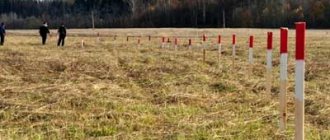
Next, you need to obtain photographic images from a satellite and correlate the received information with a map of the territory. Then measurements are taken. Boundaries must be measured using wooden pegs.
It is most appropriate to carry out the action in question when the boundaries of plots located in the neighborhood have been established and entered into the registers. It is also convenient to carry out land surveying when the plot goes into the forest, street or field. When controversial issues arise, you can turn to specialists.