Has the land plot been surveyed? This question arises for the owner for various reasons: when selling, registering an inheritance, registering a house, etc.
All real estate, including land plots, in accordance with current legislation, must be registered and accounted for with government agencies. There is such a concept - registration of real estate in the cadastral register and registration of property rights. This mandatory procedure applies to all real estate properties. However, in order to register land or a building with the cadastral register, it is necessary to carry out a number of activities to complete and collect documents.
To record land, a land surveying procedure is required, as a result of which a land survey plan is prepared.
To register houses/buildings, a technical plan is required. Both the boundary and technical plan are drawn up and signed by cadastral engineers.
Land is usually a long-term possession. It is either inherited or purchased for a long time. Laws change, requirements for paperwork are updated.
Thus, having registered ownership decades ago and completed all the necessary actions at that time, the documentation becomes outdated and requires updating.
Sometimes, having heard from a neighbor or acquaintance that he is going to carry out land surveying, you wonder if I should?
How to find out whether a land plot has been surveyed and when it was carried out? Is there a boundary plan for the plot and is it needed in case of sale or inheritance?
In fact, it is quite simple to find out whether land surveying has been done or not.
Land surveying information: what is it for?
In Russia, there is Law No. 221 “On Cadastral Work”, as well as Federal Law No. 218 “On State Registration of Real Estate”. According to these laws, measures related to clarifying the boundaries of plots are considered mandatory for all forms of real estate. Of course, this rule applies if the owner wants to legally dispose of the property and carry out various legal transactions with it.
Initially, you need to say why the surveying of your own land plot is being checked:
- if property disputes arise with the owners of neighboring lands; when before purchasing real estate you need to check its “legal purity”; when a possible seizure of the plot or its presence as collateral is checked; to determine the easement.
The Rosreestr organization issues certificates that list information about the boundaries of the site, its technical parameters, and the owner. You can issue a certificate yourself. However, to save time and money, it is recommended to entrust this work to specialists.
Why do you need information about this procedure?
In connection with the new law on mandatory land surveying, this information is needed by everyone who wants to continue to be able to manage their plot. Information will also be needed in the event of disputes with neighbors regarding the boundaries of the site, the establishment of easements, etc.
Note! The land surveying procedure is regulated by the law “On the State Real Estate Cadastre”.
Next, we will tell you how to find out whether a plot of land was surveyed in different ways.
Why do you need a public cadastral map?
Using this document, you can find out at any time whether work related to land surveying has been carried out previously. The operation is carried out online. So, here are the step-by-step instructions:
1. Opening of the PAC
2. Enter the site number and its address into the search line.
3. Information appears in the help window that you need to familiarize yourself with first.
Sometimes it happens that the area is not displayed in the open window. Accordingly, the land is not registered, and therefore there is no data about it in the PKK.
Map of land plots: checking real estate properties online
Using the updated public cadastral map of the Russian Federation, it is easy to find out detailed information about the land plot.
Reference. The database contains unique characteristics for all available plots of land within the Russian Federation.
The information blocks contain reliable data on each land plot and its territorial characteristics.
Before making a transaction or other actions with a real estate property, it is advisable to use a public map of land plots to obtain up-to-date information.
Basic information on the object of ownership implies:
- Address.
- Status.
- Exact area.
- Cadastral value.
- The form of ownership that is current at the moment.
- Date of registration with the cadastral chamber.
- Characteristics of the land.
Attention! If you use a known cadastral number, the search for an object will be simplified.
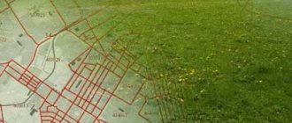
A diagram of the location of the plot of land on the map will be displayed online. The territory can also be seen in other formats: through topographic digital maps or satellite, for example
Extract from USRN
It is important to note that information about land allotment from the PKK may not always correspond to the real situation. You can find out exact information about land surveying from the Unified State Register of Real Estate. The certificate, which is prepared by Rosreestr specialists, contains the most accurate information.
To prevent users from personally contacting Rosreest, they can order an extract remotely. However, to save time and effort, people turn to professionals. For example, such a service is provided today.
The certificate is issued within one business day. The applicant pays only for the company’s services, as well as the state fee.
As a rule, a document is transferred in hand electronically, certified by an electronic digital signature. It is noteworthy that the legal force of such a document will be similar to the paper version.
It is strongly recommended to pay attention to such sections of the document as:
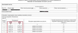
- Area parameter - the size of an individual area may be indicated with errors;
- Marks of a special nature - a certificate for a site without land surveying has the entry “The border is not established according to the requirements of the Land Code of the Russian Federation”;
- Data on the location of the site - the coordinates of the object are indicated with an error of 0.1 meters.
We determine online: was it done correctly or not?
To do this, we need a cadastral plan, which can be viewed on the Public Cadastral Map.
Let's use the resource https://pkk5.rosreestr.ru:
- A map of the Russian Federation opens in front of us. At the top left we see a column with different icons; to start the search you need to select the icon with a magnifying glass on it.
- Next to it there is a window in which “Land” is indicated, scroll through and find “Borders”.
- Now go to the input window and write the address or cadastral number.
- After entering the address, a tab will open with information about the land plot, including the cadastral plan.
Important! To familiarize yourself with it in detail, there will be an icon at the bottom of the tab; clicking on it will take you to viewing.
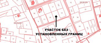
If the site has not undergone land surveying, there will be no plan for it on the PKK, and the brief information about the allotment will not indicate the name of the cadastral engineer who was responsible for determining the boundaries. That is, based on this, we draw a conclusion whether land surveying was carried out.
There are 9 tools on the public map panel, below is a brief reference for each.
- Search for a site.
The section allows you to find the desired plot by address, cadastral number, coordinates, etc. - Information about the object at the selected point.
This feature clarifies what is located in the area of interest on the map. - Editing.
The tool helps you choose what information regarding the site is needed and what information needs to be hidden. - Pencil.
With its help, you can mark the desired zone on a public map. - Ruler.
Contains data about latitude, longitude, distance, area of the selected part. - Bookmark.
It will come in handy if you have an account on Rosreestr.In this way, the desired plots can be added to favorites so that you can immediately access them without searching again.
- A printer.
Allows you to print the necessary information. - Reference.
Here you can find background information about the public cadastral map service.
On the map you can see the following information:
- cadastral number.
- Date of registration in the cadastre.
- Address.
- The category of land to which the allotment belongs.
- Square.
- Type of permitted use.
- Cadastral value.
- Form of land ownership.
- Who registered the site?
- The date the data was updated.
If the previous options did not work, you can obtain a cadastral extract online.
- Visit rosreestr.ru:
- there will be three sections: for individuals, for legal entities and specialists.
- You select the section of a legal entity or an individual (depending on which category you belong to). You will see a page with a column “Electronic services”.
- You click on the very first “Receiving information from the Unified State Register of Real Estate” and you will immediately see a form to fill out. On the right there will be a section “Public services”, you select item 6 under the account “Get a cadastral plan from the territory of the Unified State Register of Real Estate”.
- Fill in all the fields: cadastral number and landmarks of the territory.
- Just below, select the type of receipt of the statement (it can be written or electronic).
- After selecting the type of statement, enter your email to receive an electronic one and the actual one to receive a paper one;.
- Next, a window will open to check the above data. Check if there are any errors in the information you provided and click on “Submit Request”.
- After this, expect an email containing all the information for payment for the statement:
- application number;
- payment code;
- code at the end of the letter.
- Please note that the payment link will be at the end of the received email. By clicking on this link you will be taken to the “Check Request Status” page.
On this page, enter the payment code from the email.Next, you will be taken to the payment page, where you need to select the appropriate payment method.
There are such options as: payment terminal, bank card, QIWI wallet.
- Pay for the electronic version 50 rubles for individuals, 300 rubles for legal entities.
- Expect 5-10 days to receive your statement.
Having this document in paper or electronic form, you need to pay attention to the “Special Notes”. If there is no land surveying, it will be written that the boundaries have not been established or have been established, but conditionally.
Multifunctional center or department of Rosreestr?
Today, you can contact any Rosreestr service center, where specialists will provide maximum information about the land surveying (or lack thereof) of the site. You only need to submit an application for admission to the organization. Please note that this operation can be carried out by the legal representative of the applicant.
So, in order to obtain an extract from the Unified State Register, the applicant needs to collect a package of documents:
- document confirming the identity of the applicant or his legal representative; documents for real estate; receipt for payment of state duty; if the actions are carried out by a trusted person - a power of attorney.
After all the documents have been collected, the government agency will issue a receipt confirming the acceptance of the package of documents. As soon as the application is considered, an extract from the Unified State Register is issued. This procedure usually takes 3 days. The form at the multifunctional center takes 5 or more days to complete.
Why is there no plot on the cadastral map?
When a property is missing, this is due to various circumstances. Information about the land plot was not entered due to an error by Rosreestr employees or for other reasons:
- The property was not registered in the manner prescribed by law.
- Land surveying was carried out until 2001.
- There are no clearly established boundaries of the allotment.
Reference. To find out why an object is not on the map, you should send a written request to Rosreestr and wait for a response.
If it turns out that the immovable property is missing due to incorrect registration, the situation is corrected as follows:
- They do land surveying.
- Collect a list of required documents.
- The papers are sent along with the land surveying file, a receipt for payment of the state duty and a passport to Rosreestr.
After a person receives a certificate of ownership of a piece of land, it will appear on the public map.
Important! Information about newly registered areas is not immediately recorded on the map. Data is updated several times a year.
How to check the cadastral registration of a land plot
To find out information regarding the registration of an object with the State Tax Committee, you can use two methods. First: read the information on the Rosreestr website via the Internet. On the map it is easy to find information regarding not only the presence of a registered land plot, but also legal information on it.
Second method: submit a request to the MFC or the nearest branch of Rosreestr. The answer is given in the form of an extract.
Providing information may be refused in the following cases:
- Incorrect or incomplete information is provided, which makes it impossible to find the object.
- The identification or location information was entered incorrectly.
When submitting a request in person, a person will receive a document with a justified reason for the refusal.
How to check a house
To obtain information, just follow the link https://rosreestr.ru/wps/portal/p/cc_ib_portal_services to the official website of Rossreestr. Algorithm of actions:
- Select the item “Reference information on real estate objects online.”
- Follow the link and select 1 of 5 verification options.
- Provide details.
- Click on the “Generate request” button.
After completing the action, a page will open where information regarding the property will be displayed or a note that the property is not listed in the register and is not registered.
Thus, it has become much easier to personally check information regarding owned real estate properties thanks to the public cadastral map. If there is an identifier on it, it means that the property is included in the unified register.
Checking land surveying and ordering an extract from the Unified State Register online
Earlier it was said that through the PCC you can find out whether land surveying has previously been carried out on the site. If the answer is yes, then the relevant information will appear in the search window. Otherwise, the system will not find the address you are looking for.
Among other things, on the website where the PKK is located, you can place an order for documentary evidence of land surveying, namely an extract from the Unified State Register.
If you need to carry out land surveying, contact the specialists of KB-Real Estate by phone, and we will provide you with professional assistance in obtaining a land survey plan or in redistributing the site.
By what date should the land survey be completed?
It is especially important to ask the question of whether land surveying was done for owners of plots whose cadastral passports (extracts from the Unified State Register of Real Estate) were issued without this operation.
In addition, everyone who plans to donate, bequeath, or sell their plots in 2021 needs to know about the availability of land surveying. Find out whether it is possible to sell a plot or part, buy it and privatize it without land surveying here.
This is supported by Federal Law No. 447.
Legal regulation of the land surveying issue and responsible government bodies
The land surveying of territories is regulated by the Land Code of Russia (Articles 6, 30, 32, 34-36) and Federal Law No. 218 of July 13, 2015 “On State Registration of Real Estate”.
The responsible government agency is the Unified State Register. To obtain data or documents, you must contact its office. First you need to write an application and attach a copy of your identification document to it. The response comes within 5 days after the application is accepted.
If land surveying is in the past, but the information is lost
You must order a statement in the form of paper or email. They can be issued not only for your own land plot, but also for other territories. The paper type of certificate is easy to obtain from the Federal State Registration Service or other administrative centers.
After receiving the document, you need to look and carefully check section 16. Land surveying was not carried out if the boundaries were entered in exact numbers and in conventional coordinates. Information about the site is present in Rosreestr if there are slight deviations in area. They should not exceed the permissible possible values (listed above).
Free surveying is provided to owners, people with lifelong inheritance rights and tenants. Other categories of individuals are required to pay. They will give a more accurate answer where the CP is done - at the cadastral authority.