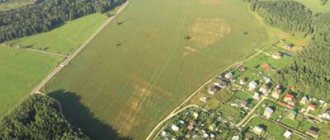
In the process of forming a land plot as an independent unit for which ownership is available or allocated, one of the main definitions used to distinguish an object from the mass of land is the border of the land plot.
It is understood as a contour line that defines by its outline the ownership of one person or group of persons.
Initially, such a line is located exclusively on paper or electronic media, but subsequently a procedure for allocating a plot is carried out, during which boundaries are established in kind, that is, they are delineated on the ground by a closed line, within which the plot will be contained that belongs to the person under the rights of ownership or use.
What it is?
In accordance with the articles of the Land Code of the Russian Federation, the boundary of a site is understood as a line defining the location of a specific area (unit), which includes all existing subsoil, as well as the soil layer itself.
Thus, this line limits the property rights of a certain individual. or legal persons, simultaneously installing it on all buildings of the territory, as well as natural objects.
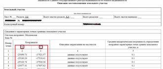
The establishment of boundaries is carried out in accordance with the coordinates of the terrain, as well as characteristic points, which are also called turning points.
When determining the boundaries of land plots, a concept such as multi-contour , that is, a single ownership consists of several selected parts that may not even intersect.
At the same time, they represent a single whole, having a gap between themselves, provoked by the passage of other land plots located by natural objects.
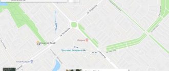
What is a public card for?
A map of land plots is an electronic file cabinet where information about each object registered for a specific enterprise or citizen is stored. Anyone can gain access to primary information. The database includes all registered land plots, data on which is in the real estate cadastre of the Russian Federation.
To work with the map, the service provides simple functionality that allows you to find cadastral division units, objects of interest and obtain information from the archives of the State Property Committee.
Using an electronic card you can get:
- detailed information on a specific real estate property;
- cadastral division, find out the boundaries with adjacent territories;
- whether the site belongs to zones with special conditions of use.
It is extremely important to know in advance if a property is allowed to be used with restrictions.
also worth finding out information about neighboring adjacent territories so that there are no restrictions on them. Otherwise, it will be impossible to engage in any type of activity on the land due to its proximity to special objects, which makes the purchase impractical.
If the plot number is known, then its location and boundaries with neighboring lands can be established.
Using the service is similar to searching in Google Maps.
But in addition to the address, numbers assigned to objects are used.
The public cadastral map allows you to find out only primary information about the site .
Information is provided about whether a specific plot exists, in what area it is located and whether it has official registration.
The cadastral number assigned to each object is a number consisting of several parts. By number you can determine whether you belong to a particular region.
If the address of a building or land plot is known, then it is easy to determine its cadastral number or vice versa:
- The first digits indicate the county
- second - district
- 3rd part – quarter
- 4th – section
After the object is found and appears on the screen, you can get more detailed information by clicking on it.
The map is presented to scale with easy-to-use visualization tools for viewing. Using an electronic card index, you can view satellite images of the area, digital topographic maps and orthophoto coverages .
If you need information about the status of an object, you can find out this information. An object can be accounted for, previously accounted for, or temporary.
Kinds
When considering the concept of cadastral boundaries, in this case, two concepts are actually used that are somewhat different from each other - the cadastral boundary and the actual one.
Cadastral
The concept of a cadastral boundary can be called an official or documentary definition.
That is, this is the line that runs between the coordinates of the points determined by the cadastral engineer when drawing up the boundary plan.
In turn, the cadastral boundary is divided into two separate definitions - declared and geodetic .
At the same time, those declared can only be of an approximate nature and are practically not taken as a basis for establishing boundaries.
Geodesics contain exact coordinates and geodetic points.
Actual
Actual boundaries mean those lines that are drawn directly at the location of the plots.
Boundaries are drawn onto the area during the process of drawing up a boundary plan, when a cadastral engineer goes to the area and, after carrying out the approval procedure, establishes the turning points of the plot.
Subsequently, a line drawn between them forms a closed-type contour , which will act as the actual border.
Clarification of the boundaries of a land plot is carried out in relation to land plots for which the exact boundaries are not defined (the coordinates of the characteristic points of the boundaries are not established).
You can clarify the boundaries of a land plot on your own initiative or when performing complex cadastral work. As part of this procedure, the specified boundaries must be agreed upon. New information about the boundaries of the land plot is entered into the Unified State Register of Real Estate. This must be done in the case when a land plot that is publicly owned is provided without bidding. It will not be provided to you if the boundaries of such a site are subject to clarification. There are no other mandatory cases when it is necessary to clarify the boundaries of a land plot. It should be taken into account that previously plots were placed on cadastral registration without determining their exact boundaries. Therefore, a large number of areas in the Unified State Register of Real Estate do not have exact boundaries. If the coordinates of characteristic boundary points have not been established for a land plot, it is recommended to carry out a procedure for clarifying them. As a result, the exact boundaries of the land plot will be determined. First of all, this will protect the owner from appropriation of part of the plot and disputes with the owners of adjacent plots about the location of the boundaries. Clarification of the location of the boundaries of a land plot is allowed in cases where the Unified State Register of Real Estate: - does not contain information about the coordinates of characteristic points of the boundaries; — the coordinates of characteristic points of the boundaries are determined with an accuracy lower than the standard accuracy for lands of a certain purpose; — information about the coordinates of any characteristic point of the borders does not allow one to unambiguously determine its position on the ground; — there is an error, including a registry error, about the location of the borders and measures are being taken to correct it. Currently, the boundaries of a land plot can be clarified both at the initiative of the owner and during the performance of complex cadastral work. To clarify the boundaries of a land plot, you must contact a cadastral engineer and conclude an agreement to perform cadastral work. As a result of cadastral work, a boundary map is drawn up, which will determine the exact boundaries of your land plot. When clarifying the boundaries of a plot, the boundary plan must include information on the approval of the boundaries of the land plot. Complex cadastral work is carried out in relation to most real estate objects located within the boundaries of one or several adjacent cadastral blocks. This is necessary in order to clarify the boundaries of land plots, establish (clarify) the location of buildings and structures on them, form new land plots, as well as to correct registry errors in information about the boundaries of land plots. To clarify the boundaries of a land plot, information from documents on the right to land plot. If they are not there, you can use documents on the boundaries of the site when it was formed. If there are no such documents, the boundaries of the land plot are considered to be those that have existed in the area for 15 years or more and are fixed by natural or artificial objects. Boundaries can also be determined using other documents, for example, planning and cartographic materials available in local governments of urban districts. Based on the results of comprehensive cadastral work, a map-plan of the territory is prepared. It includes information on the approval of land boundaries. When clarifying the boundaries of land plots, their approval is carried out. The approval procedure differs depending on how the boundaries of the site are specified - on your initiative or during complex cadastral work. The boundaries of adjacent land plots must be agreed if their clarification was carried out at the initiative of the owner. This is also done in the case when the boundaries of adjacent land plots, information about which is included in the Unified State Register, are clarified. The boundaries of the plot are agreed upon with the following persons who own adjacent land plots: - owners, except in cases where the plot is in public ownership and is provided with the right of lifelong inheritable possession or the right of permanent perpetual use; - persons to whom the plot belongs by the right of lifelong inheritable ownership or permanent (indefinite) use; - tenants, if the site is publicly owned and leased for a period of more than five years. Coordination can also be carried out with representatives of these persons. Coordination of the boundaries of a land plot can be carried out: - with or without establishing boundaries on the ground; - by meeting or individually with each person. If a meeting is held, then all interested parties (their representatives) are given a notice of the meeting against receipt (sent by mail or e-mail to the address contained in the Unified State Register of Real Estate). In some cases, it may be published in official media. Notice must be served, posted, or published at least 30 days before the meeting. As a result of the approval of the boundaries of the land plot, an approval act is drawn up on the back of the sheet of the graphic part of the boundary plan. Entering updated information about the boundaries of a land plot into the Unified State Register of Real Estate is carried out by applying to Rosreestr for cadastral registration of changes in the description of the location of the boundaries of the land plot and (or) its area.
Requirements for boundaries
In the process of forming a boundary and establishing turning or characteristic points, the cadastral engineer must take into account the requirements that it must meet.
So, you will need to follow the following rules :
- The boundaries of the allotment should not intersect with any territorial boundaries of municipal settlements or settlements;
- The contour of the plot (border of the allotment) should be as simple . That is, the ideal shape is a quadrilateral. Of course, due to natural characteristics, configurations of neighboring areas and other factors, it is not always possible to achieve minimal fracture;
- The contour of the site should not intersect adjacent plots . In such a situation, one section will overlap another (partially or even completely);
- The boundaries must be determined in such a way that the site has access to the roadway and all communications passing in the area are accessible to it.
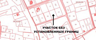
What to do if boundaries are not set?
The absence of established boundaries for a land plot imposes a lot of restrictions on actions with it . If it is necessary to determine it, the owner or other interested party must perform a number of actions in accordance with the established procedure of the Land Code of the Russian Federation and the Federal Law regulating cadastral activities.
Engineer invitation
In fact, inviting an engineer becomes the initial stage of the land surveying process, when the owner of the plot enters into an agreement to determine the boundaries of the plot.
When choosing a geodetic organization, you must pay special attention to ensuring that the engineer performing the work has permission (license) for this type of activity , otherwise the drawn up plan will not have legal force.
Coordination with neighbors
An obligatory stage in the formation of boundaries is the moment of agreement on the passing boundary with interested parties - the neighbors of the plot, whose plots are directly in contact with the one of interest along the dividing line.
All owners of adjacent plots are notified in advance by personally delivering a notice, sending a document by email or Russian post, or publishing an advertisement in a local newspaper.
Everyone appears at the appointed time at the location of the land plot and gets acquainted with information regarding the passage of the boundary. If there are no objections, the neighbors sign as a sign of consent and the boundary is considered possible for display and display on the site.
Measurement and determination of coordinates
When determining the boundaries of an allotment, an equally important procedure is the engineer’s visit to the area to determine the establishment of turning points and the passage of boundaries. This procedure is necessary in order to take into account all the features of the terrain , as well as the actual location of neighboring areas.
Appeal to the territorial chamber
After the boundaries are established and the boundary plan is officially drawn up, the owner of the plot has the opportunity to contact the cadastral chamber. Such an appeal is carried out for the purpose of entering data on the allotment into a unified state register .
In parallel with this action, the owner has the opportunity to obtain a cadastral passport, on the basis of which it is possible to obtain ownership rights.
Determining boundaries through court
There are situations when the division of territory can only be done through the courts. Typically, this happens in the following cases:
- The neighbors did not approve of the boundaries and refuse to sign the agreement;
- The land survey took place a long time ago, but the owner does not agree with its result. This situation is not uncommon. For example, the neighbors decided to seize part of the land, and the former owner of your plot agreed without looking;
- At the stage of taking measurements, it turned out that the border runs through someone else’s territory. If the measurement has not been carried out for a long time, and the neighbors have occupied part of the site;
- Land surveying and division of land took place without the participation of the owner. For example, when he did not receive notifications about measurements.
If disputes arise, land owners in garden partnerships (SNTs), for starters, can contact the chairman (to resolve the issue peacefully), and if unsuccessful, go to court.
Arbitrage practice
Here are a few examples of lawsuits and their results:
Case 1
After taking measurements, the plaintiff sent documents to the Cadastral Chamber for further registration of the land. But he was refused due to the fact that his site already intersected with a nearby one, although no intersection was identified during land surveying.
The plaintiff demanded that the mistake in the neighbor’s papers be corrected, that the measurements be remeasured and new coordinates corresponding to reality be established. This requirement was satisfied by the court.
Case 2
The cadastral chamber refused the plaintiff's application to register the plot, citing the fact that it entered someone else's territory. During the investigation, it turned out that the neighbor illegally occupied part of the land, and his land surveying procedure was carried out with errors, as it was not agreed with the plaintiff.
The court made a positive decision and satisfied the applicant's demands.
Case 3
When trying to come to an agreement with the owners of neighboring plots and the location of the boundaries, the plaintiff was faced with misunderstanding and refusal. He explained this by saying that he exchanged land allotment with a third party and is now cultivating it, but when selling the allotment, the plaintiff was told that the border is located on this land, so a dispute arose.
The court rejected the claim and sided with the defendant.
From this we can conclude that going to court is not always a losing proposition. When a controversial situation arises and you know that you are right, filing a lawsuit makes sense, and most likely the judicial authorities will take your side after considering the details of the case.
With what accuracy are they determined?
In the process of defining boundaries and placing them on the ground, turning points are established, between which contour lines are drawn.
Due to various factors such as engineer errors, weather conditions, erroneous information, outdated or uncorrected equipment, the accuracy of the boundaries may not be complete.
In such a situation, the law establishes certain standards that contain data on permissible errors in establishing site boundaries.
the following indicators
should be established :
- For those areas that are located in the zone of a populated area - 10 cm;
- For plots intended for a summer house, home, garden, vegetable garden, etc. – 20 cm;
- For agricultural plots, this error can be greater and amount to up to 2.5 meters.
How to obtain an extract from the Unified State Register of Real Estate?
There are two types of USRN extract: paper and electronic. The first version of the document will cost 350 rubles for individuals, and 950 for organizations. You can only obtain it by contacting official government bodies in person: the MFC or a branch of Rosreestr. You need to wait from 5 to 9 working days for the completed certificate.
An electronic version of the statement can be obtained in several ways. The fastest way is to use the help of the official partner of Rosreestr - the EGRN.Reestr portal. A USRN extract will cost from 200 to 350 rubles, depending on its type. After you enter the address of the site or its cadastral number, you will need to wait half an hour. An electronic extract from the Unified State Register will be sent to you by email.
The lack of precise boundaries on plots is the most common cause of disputes between neighbors. To avoid such situations, take care of entering your land plot into the Unified State Register of Real Estate. And the EGRN.Register will help you understand the reasons for the lack of borders.
Text: Ksenia Antonova
Where can I find out the boundaries of the allotment?
Many plot owners often wonder how they can obtain information regarding the boundaries of a land plot.
This information may become available after you complete the following steps :
- Obtain information on the Rosreestr website. To do this, you need to go to the portal and enter the cadastral number of the plot. The window that opens will contain all the necessary information on it, as well as data on the boundaries of the site;
- Contact the Rosreestr branch . To do this, you will need to send an official request and wait for the result. Due to the fact that this method takes quite a long time to provide information, it is no longer used so often;
- Obtaining information from cadastral documentation for the site. If you have such papers in your hands, it is enough to open the boundary plan or cadastral passport and get all the data regarding the boundaries.
When is it necessary to change the boundaries of a land plot?
There are several cases when it is necessary to carry out land surveying. These include:
- Erroneous initial change of site boundaries. This happens if the surveying company made mistakes and inaccuracies. Usually such manipulation is carried out again free of charge. The land owner only makes a second request.
- Natural blurring of boundaries. Over time, boundaries may disappear. A neighbor has moved the fence to your property a couple of centimeters, or the outdated documentation does not clearly show the area of the property.
- In connection with the statement of neighbors. If the neighbors filed a statement that they doubt the correctness of the measurement or noticed that you have taken over the area of someone else's plot. If there is an unauthorized increase in the plot by one of the neighbors, this must be proven.
- An application was received from the owner of the site. This issue is resolved if there is a need to separate or combine two adjacent areas. This is possible when buying or selling.
- In order to clarify the boundaries. If there is a discrepancy in land surveying: the documents indicate one thing, but on the ground it is actually another.
What is a contiguous boundary?
An adjacent property line is a line that is superimposed over the actual property line where lot lines follow the boundary of an adjacent property. Unlike the main boundary of the site, which is built along characteristic points, such lines are determined by the interval of overlap with the adjacent land plot .
The border of the adjacent plot on the plan is displayed outside (behind the main line) and before being displayed also requires prior approval with the direct owner of the adjacent plot .
How to fix it yourself
If you decide to personally deal with the elimination of inaccuracies, you need to understand how to independently correct the error in the location of the boundaries of the site.
All actions in several steps - filling out an application and submitting it to the government agency.
In order for the information to be corrected, you need to apply to the Federal Service for State Registration, Cadastre and Cartography. A neighbor who needs to obtain reliable data about the adjacent plot can also submit an appeal (before this, you need to order an extract from the Unified State Register of Real Estate ).
The application is submitted in writing in accordance with the procedure established by law. Experts recommend that you carefully fill out clause 3.1.2, which states where the error was made. After preparing the application, the application and package of documents are submitted to the registration authority.
If an adjacent one was superimposed on your area, you can eliminate the inaccuracies yourself. If an adjacent plot is placed on your plot, either contact the registration authority (if the neighbors are not against making adjustments) or through the court, if the neighbors refuse to make adjustments.
What to do in case of intersection?
The intersection of plot boundaries means their displacement in any direction, while the boundaries of the plot directly intersect .
Such cases may occur when errors occur in drawing up a boundary plan for one of the neighboring areas, or both at the same time.
In addition, such cases arise when the territory is squatted, unauthorized movement and displacement of the boundaries of the site under the influence of third-party factors.
If such errors are detected, the site owner must perform the following actions :
- Contact Rosreestr with an application to clarify the boundaries (if such a situation occurs after entering information on both sections into Rosreestr);
- Agree on the location of the boundaries of the site, if such a situation arose during the formation of the boundary plan. In this case, a similar action can be performed by a cadastral engineer;
- If it is impossible to solve the problem of crossing boundaries peacefully, file a claim in court to establish the actual boundaries and eliminate all inaccuracies or consequences of illegal actions of land owners.
Why does the error occur?
The causes of errors in the cadastral map are most often three factors:
- Errors of a specialist, a cadastral engineer, who entered the coordinates of the site into the plan. In this situation, errors are initially contained in the registration data entered into the Unified State Register of Real Estate.
- Error, typo of the technical employee who entered data into the cadastral map program. In this case, the coordinates indicated in the documents are correct; erroneous boundaries are displayed only on the map.
- Errors in satellite video recording are not an error, since in the original version the information about the boundaries was entered correctly.
The procedure for correcting errors in the location of boundaries on a public cadastral map depends on the specific situation. In some cases, it is enough to simply identify an error, draw up the necessary documents and, based on them, make correct changes to the USRN database and the map. In other situations, the rights of the owner or controversial issues of the owners of neighboring plots will have to be resolved in court. Changes are made accordingly by Rosreestr and the map based on a court decision. Next, we will consider several types of errors and options for correcting them.
The concept of brokenness
Fracture is understood as the specific placement of turning points of an allotment, which is formed by the existing adjacent allotments, the specifics of the existing soils, as well as the conditions of the relief and landscape of the area.
Ideally, the site should have only 4 characteristic points and, as a consequence, 4 boundaries. In practice, land plots are not always presented in this form, and the more such turning points there are, the more irregular the plot boundary becomes.
High irregularity significantly complicates geodetic, cartographic and topographical work.
In this regard, engineers, when determining the boundaries of the site, try to achieve minimal fracture (as far as possible in a particular situation).
What to do if the land is owned, but there are no boundaries
It happens that a plot of land becomes owned by inheritance or a gift agreement. This outcome is possible due to the influence of various factors: loss of documents, incorrect transfer of ownership of the territory.
The owned plot should not remain without borders; it will then be impossible to sell it Source geroj-nashego-vremeni.ru
Such a phenomenon is a reason to urgently contact a geodetic company to put the site in order. After all, without precise boundaries, it is not possible to sell it, pass it on by inheritance and do other manipulations.
Important! In such a situation, there is a risk that the land surveying procedure will take more than 6 months.
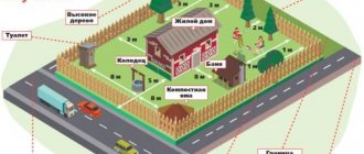
Land surveying is also carried out for the purpose of correct installation of fences Source geomergroup.ru
If a body of water is found on the site during land surveying, it must be included in the plan Source estvaind.ru