Land surveying is a process that involves clarifying and determining the boundaries of lands, their locations and areas. Without going through the land surveying procedure and without having an up-to-date land survey plan on paper and electronic media, it will be impossible to make any disposal of the property - sale, rental and even inheritance.
What to do after the site surveying procedure and how to use the survey plan will be discussed in this material.
What kind of document is this?
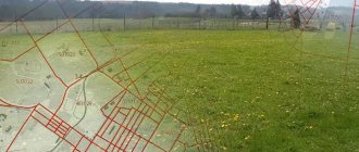
The layout of a land plot is a document, a drawing on paper, which displays the boundaries of the territory formed or redistributed according to the cadastral plan.
It must be attached to a document issued by executive authorities, which describes the characteristics of a given plot of land. The order clearly states the coordinates of the territory with an accuracy of meters, its area and shape. A civilian has every right to prepare the drawing independently, but in order to avoid mistakes, delays in the procedure and fines, you should immediately contact the specialists of the GeoStroyProekt company and entrust this process to them.
The difference between land surveying and cadastral work, geodesy and privatization
Land surveying is often confused with other procedures in the field of land management. Let's look at each of them.
Cadastral work is a type of work on the preparation and preparation of any documents on real estate. This includes drawing up a technical and boundary plan.
Geodesy is responsible for measuring, designing and processing data in the form of drawings; it is necessary to draw up a plan for the placement of objects on the site. A surveyor can determine and establish the boundaries of a site on a par with a cadastral engineer, as well as perform calculations of excavation work on a site, determine the vertical and horizontal lines for a construction site, and outline construction sites and placement of communications.
Land privatization is the transfer of state property into personal property. The owner of the plot receives documents for the right to own the land and the opportunity to dispose of it at his own discretion: sell, donate, inherit.
When do you need a land plot layout diagram?
The layout of the land plot is required:
- To form a specific plot when it is transferred without bargaining
- If the formed plot will be sold at auction or rented out
- If the territory is allocated from land that belongs to a municipality or legal entity on terms of use without a time limit
- If a land plot that belongs to the state or is given to a legal entity or individual for rent or for free exploitation is divided
- If plots are formed during the redistribution of territories that are in the possession of individuals and are intended for maintaining a garden, vegetable garden, other rural work, individual housing construction, etc., or the land that is owned by the state
- To prepare and determine a plot of land, which will then be withdrawn in favor of the municipality or the state
FAQ
Is it true that a law has been passed according to which land surveying of a summer cottage can be carried out free of charge?
According to No. 221-FZ chapter 4.1. money has been allocated to carry out comprehensive cadastral work. That is, land surveying and drawing up boundary plans are carried out not for one site, but for an entire cadastral quarter. A plan for carrying out complex work is drawn up by local authorities. You can find out in which settlements and in which areas complex work will take place from the media or on the portals of local governments. Owners of plots that belong to a certain cadastral block must only provide access to the territory of the plot, and money to pay for land surveying will be allocated from the budget.
What to do if a neighbor does not give his consent to determine the boundaries of the property?
You should double-check the documents and try to resolve disagreements peacefully. If you can’t reach an agreement, then write a complaint to the prosecutor’s office and then to the court. Then the boundaries will be determined in court and a boundary plan drawn up.
Is it possible to carry out land surveying for free under the dacha amnesty?
The dacha amnesty allows you to quickly and free of charge register the land and buildings on it as your property. But the dacha amnesty does not include the land surveying procedure, which must be ordered separately.
Is land surveying a mandatory procedure for land owners?
This legislation does not require owners to carry out mandatory land surveying. But if you intend to sell the house or pass it on by inheritance, then by law this cannot be done without a boundary plan. Also, timely land surveying will allow you to avoid conflicts with neighbors over illegally seized lands.
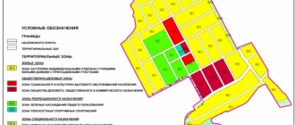
What is shown on the diagram?
The layout plan of the land plot must necessarily show:
- Conditional number.
- The area in accordance with the design of each allocated territory.
- A list of coordinates of border points of all participants in accordance with the planning organization scheme of the land plot in the system that is established for maintaining the state real estate cadastre.
- Configuration of the boundaries of newly received, already recorded and original land territories.
- Conventional signs that were used in preparing the layout of the land plot.
- All information about plan approval. If it was certified by certain authorities, it is required to indicate which ones, as well as the date, name of the document and its number.
- If the plan was approved through an agreement between various authorized bodies, then it will be necessary to indicate the names of these organizations, the name of the certificate, its number and when the agreement was concluded.
Is it possible to make it yourself? And how to do this?
In this life, you can do almost everything yourself. It would seem that what could be difficult about simple measurements and displaying them on a drawing? But in reality, there are enough difficulties. So, you will not be able to independently coordinate and correctly take measurements.
Most likely, without having the education of an engineer and the experience of a qualified cadastral engineer, you will probably make a number of mistakes , which will later become fatal for you. You will have to apply again for the production of a boundary plan.
Even if you manage to draw up a boundary plan yourself, using all the designations and all the terminology necessary for this, your plan will not have legal force.
The fact is that it is in the cadastral chamber that the seal and signatures necessary for this are placed on the plan. Of course, if you are making a land survey plan purely for yourself, you can try your luck on your own and try to draw up a land survey plan.
But if you plan to make any transactions with land in the future , then you will be disappointed. Your boundary plan, executed without certain forms intended for this purpose, will simply not take place and most likely, the buyer or another participant in the transaction will understand that the document was not created by a government agency and will prefer not to contact you.
Therefore, if you really want to save money, it is better to think ten times, lest your savings later come to you in the other direction and result in even greater financial losses.
You can download a sample boundary plan here.
How to prepare a land plot layout diagram
To prepare a diagram of the location of a land plot on a cadastral plan, today it is most convenient to use an electronic document format. But there are cases when a plan is needed by a civilian in order to transfer a plot of land without bidding. In this case, it can be made in two forms - in the form of an electronic document or a regular paper document.
In the preparation process, it is permitted to use the official website of a federal executive body that has the appropriate powers. The requirements for preparing a land plot location diagram in electronic format are officially approved by the Order of the Ministry of Economic Development of the Russian Federation dated November 27, 2014.
Conclusion
- You cannot carry out land surveying and determine the boundaries of the site yourself; for this you need to have a license for geodetic and cartographic activities.
- Land surveying is not a mandatory procedure for land owners. But if transactions involving the transfer of land ownership are planned, the boundaries of the site must be clearly defined, which means that a boundary plan will be required.
- When choosing a cadastral engineer to draw up a boundary plan, check whether he is a member of an SRO. If a specialist is not a member of a self-regulatory organization, then the documents that he draws up will be considered invalid.
What documents are required
Sample layout of a land plot
With the help of a document such as a map of the location of a land plot on the ground, in accordance with the cadastral plan, it is possible to form an allotment with which it will be possible to carry out any actions that have legal force without hindrance and in full compliance with the law.
That is why, when a package of necessary documentation is being collected, before submitting it to the cadastral engineer, special attention should be paid to those papers, certificates, decisions, etc. that could confirm the legality of the application for the execution of the land plot location plan. It is troublesome and problematic for a non-professional to independently collect a complete set of all papers and check their correctness, for this reason it is more advisable to order a similar service from the appropriate one operating in Penza and the Penza region. The cost of the service is not as high as many people believe, compared to the hassle and risks that you are guaranteed to avoid with our help.
The list of mandatory documentation for preparation includes:
- Cadastral passport for territories that were previously allocated, or for an existing plot, if it is registered. If the plot is registered with the Rosreestr authorities and is assigned the corresponding number, then it must be clearly indicated.
- A written order from the leading person of the authorized body on the preparation of the allocation or formation of an allotment.
- Any documents that could confirm the identity of the person ordering the service.
- If the territory to be transformed was registered on the right of ownership or possession, and there are documents that could confirm its official status, then you need to attach them and all existing related certificates and certificates.
- Documentation that confirms the drawing up of land layout plans or cadastral plans in the past.
Cost of the boundary plan
The price depends on many factors, each of which increases or decreases the cost of the work.
Our company has an average pricing policy. We are confident that good, high-quality work will not be cheap. When drawing up the plan, very expensive equipment is used, the engineers are very well educated. In order to properly draw up a good plan, you need specialized software, which is very expensive and installed on expensive equipment. Workers who perform these jobs are subject to both personal and criminal liability. Because of all this, such work cannot be very cheap.
Even if you decide that our company’s pricing policy does not suit you, we do not recommend turning to very inexpensive specialists. This could be a huge mistake. To ensure that your plan is accurately accepted by a government agency and that no problems arise, you should only contact good specialists who have extensive experience in drawing up such plans.
We will do all the work for you, prepare everything you need. Our engineers have been working on such plans for a very long time.
Attention!
The information on the site is more for informational purposes and provides basic knowledge on your problem.
Each individual case is individual, so you can check any information with our on-duty legal consultants 24/7 and free of charge.
For what reasons may approval of a land plot layout scheme be refused?
For approval, the layout of the land plot on the ground is sent to the executive bodies of state power. You can also contact local government organizations that have the authority to manage territories owned by the municipality. Reasons for refusal to prepare a diagram of the location of a land plot on the cadastral plan may be:
- Inconsistency between the territory plan and its actual location and configuration, with the required document format, or with the requirements for the process itself
- If, when developing a plan for the location of a plot of land, the standards specified in Article 11-9 of the Code of the Russian Federation were violated
- If the layout of the site does not coincide with the territorial planning project, regulations on territories that are especially protected or land management documentation
- If the backlog that will be formed according to the prepared plan is located on the territory of the land that is subject to demarcation
- If a complete or partial coincidence of the plot with the location of the plot that was formed taking into account the previous scheme is revealed if the document is still valid
What types of boundary plans are there?
Land survey plan
There are several types of boundary plans. There are three main subgroups of boundary plans:
- To form a plot of land. This is both a combination and division of land plots. You can combine two or more areas that have an adjacent border, but are divided into two or more parts. Also, such documents will be needed when allocating land plots, when distributing plots, as well as when forming a plot from different lands.
- A boundary plan can be created in order to clarify the boundaries of a land plot.
- To correct cadastral errors.
When forming all these plans, there are many nuances that can only be entrusted to professionals.
Where can I order a layout plan for a plot of land in Penza?
In order to minimize the likelihood of refusal and avoid possible problems with authorities in the future, it is necessary to strictly follow the procedure for preparing land plot layout plans. It is equally important to collect a complete package of documents, carefully monitoring their legal accuracy and current validity period. Therefore, it is safer and more economical to order a plan for the location of a house on a plot of land from qualified specialists in Penza and the Penza region.
in Penza offers a full range of services in everything related to the preparation of a planning organization scheme for a land plot in a cadastral territory. We guarantee a competent approach to any issue and high-quality implementation of all stages of the procedure. We draw the attention of our clients in Penza: it is not a cadastral engineer who works with us with papers, a project and a scheme, but a qualified land surveyor with extensive experience who is well versed in his business. This means that your documentation will be in good hands, and you will definitely not encounter standard difficulties due to ignorance of the laws.
Our company’s employees are ready to provide free advice and provide prices to each client - you can call us on our hotline or write to our email. All contacts available to customers are listed in the corresponding section of our website.
Procedure and instructions
It would seem that the boundary plan is a fairly important and weighty document, which means that it is not so easy to obtain. But to be honest, this is all a big misconception. The fact is that today it will not be difficult to obtain a boundary plan, but only if you fully comply with the algorithm of actions.
There are many clarifications and nuances in the procedure for obtaining a boundary plan that you should familiarize yourself with in more detail. Our next paragraphs will be devoted to this.
Let's return to the algorithm of actions. In order to quickly obtain a boundary plan you will need:
- collection of documents for land, including documents on ownership;
- contacting the cadastral chamber to obtain the services of a cadastral engineer;
- carrying out work by a cadastral engineer to measure the site for the boundary plan;
- collection of documents for submission to the cadastral chamber;
- payment of state duty;
- submission of documents;
- waiting for the result.
Agree, nothing complicated can be found in the actions we have listed.
That is why you should not delay inviting a cadastral engineer. It is he who, having carried out survey work on the site, gives you the right to further apply for a boundary plan.
Also, it is important to remember that not any cadastral engineer can carry out measurements, but only those with a certain qualification.
Where to get it?
Of course, a boundary plan cannot be obtained from a government agency not designated for this purpose. There is a specially formed organization for this purpose. In order to draw up the correct boundary plan, you need not only many years of experience and skill , but also special knowledge that only specialists in their field have.
It’s not for nothing that the boundary plan is so similar to the cadastral plan. The fact is that whoever is responsible for issuing the cadastral map is also responsible for issuing the boundary plan, a specially created chamber called the cadastral chamber.
It is in this chamber that you can obtain a boundary passport. Many people mistakenly believe that the boundary plan can be drawn up by both the Rosreestr and the land committee. This opinion is wrong, because these organizations perform slightly different work. The scope of their activities includes reviewing and entering information into state registers.
The cadastral chamber, when preparing a boundary plan for you, does not involve other bodies , which means that you simply need to contact the cadastral chamber directly.
Coordination of the boundary plan
An entire article of the land code is devoted to the coordination of the boundaries of the boundary plan, and there are also references in many regulatory legal acts.
These articles speak of the mandatory nature of approval. But with whom should we coordinate boundaries when carrying out boundary work? Of course, with the people who are directly affected by these works.
Firstly, these are, of course, the owners of your land, if any.
Also, these are the owners of adjacent plots, because if incorrect measurements are taken and erroneous data provided by you, they risk losing part of their plot and facing you in court.
In order to carry out boundary work, and then, on their basis, draw up a boundary plan, which, by the way, will entail the preparation of a cadastral plan, their full consent is necessary.
It is good if consent is given in writing. This way you can completely protect yourself from further attacks on your land shares. Be sure to ensure that all owners take part in the approval. By the way, tenants of land plots, heirs who have not yet entered into their rights to receive an inheritance are also equal to the owners and have the right to vote.
Preparation and requirements for it
The preparation of a boundary plan takes place in several stages and involves a lot of actions and documents. Of course, first of all, this is not your headache, but still, it will be useful for you to know what the stage of preparing a boundary plan includes.
First of all, employees of the cadastral chamber study the results of boundary work . They also get acquainted with the consents of other owners.
All this information is carefully analyzed. Further, you need to remember that already at the initial stage of applying to the cadastral chamber you already have a document that discloses all the information about the site. This information is included in various types of registers, and can only be obtained in the form of an extract.
Employees of the cadastral chamber get acquainted with the results of the extract , survey work carried out and consents. Based on these documents, a so-called boundary plan is created. It must be said that these are not all the documents necessary for the preparation stage and for the compilation stage. We'll talk more about this a little later.
Dates of issue
The deadline for issuing a boundary plan by the cadastral chamber may be the information specified in the law. This period is one week to fifteen days, excluding weekends and holidays. Thus, you can focus on these deadlines.
But sometimes situations arise that require a little more time . For example, you did not include some very important document, or you never received it at all.
There may be an error and you may need to wait for it to be fixed.
You can also lose a lot of time if your situation is considered non-standard to some extent.
What is the price?
The cost of carrying out such work is not too high, but it can consist of several aspects. Firstly, this is, of course, a state duty. Its size is not that big, but you should never forget about it.
The second component of the funds that will be spent on repaying the payment for the production of a cadastral plan is the services of a cadastral engineer for taking measurements and also for drawing up the plan itself.
As a rule, the cost is calculated based on the area of the plot . There is no point in giving examples of property. Municipalities and entities have taken responsibility for setting prices for such work.
That is why if you want to calculate the amount it will cost you to create a boundary passport, ask for a cost estimate directly from the cadastral chamber.
Required documents
The question of what documents are needed in order to create a boundary plan is difficult to answer unambiguously. The fact is that each case is unique in its own way, which means that it is possible that in your case the package of documents will differ from the general standards.
But there are documents that must be presented without fail . Let's look at them.
Let's start with a passport, or rather a photocopy. When submitting an application for land surveying work, you must provide copies of passports of all owners. Next, you need to remember that you will also have to make copies of numerous title documents.
Also, do not forget about the documents characterizing the land plot. You may still have a cadastral passport or some kind of cadastral extract. You should also have the results of land surveying work carried out on your site.
All these documents give you the right to apply to the cadastral chamber. Do not forget about a document that would indicate payment of the state fee. Only if it is available will your package be accepted for consideration.
Cost of preparing the scheme
Preparing a site layout plan is a labor-intensive process, consisting of several stages, therefore the final cost will be determined based on the complexity and duration of each stage. But in any case, we offer the most loyal prices in Penza, with high professionalism, decent quality and speed of work. Today, for legal entities, the cost of the service starts from 20 thousand rubles, without an engineer visiting the site (ordered and paid by agreement), for individuals - from 7.5 thousand rubles to 10 thousand rubles, a visit and consultation of a cadastral specialist will cost five thousand. Preparing a site layout plays a key role in the construction of any facility, so do not take risks and do not try to save money on this important point.
General provisions
A document called a boundary plan is part of the cadastral documentation that establishes the size of the property, its boundaries and exact location. The plan is drawn up based on the results of land surveying carried out by cadastral service specialists and is included in a package of papers called land surveying. The place where you can get this documentation is a licensed specialized land management organization.
Based on the data reflected in the document, basic information about the land is obtained for:
- Confirmation of ownership of a specific territory.
- Control and accounting of real estate by the state.
In the process of drawing up a land surveying plan, the cadastral engineer is obliged to adhere to the new legislative requirements regulating this process at the federal level: articles of laws Federal Law-221 (2007), Federal Law-171 (2014), Federal Law No. 122 (1997) (note: Document becomes invalid on January 1, 2021 due to the publication of Federal Law No. 361-FZ dated July 3, 2016. From January 1, 2017, state registration of real estate is carried out in the manner established by Federal Law dated July 13, 2015 No. 218-FZ)
A special service consisting of cadastral engineers has the competence to carry out land surveying and draw up the corresponding plan.
When intending to prepare a boundary plan, property owners should proceed from the latest legislative changes:
- When submitting a request for the preparation of a land survey plan, an individual is required to sign a document authorizing the processing of personal information about the applicant.
- The document must contain a section with general information about the cadastral work performed (a link to the contract on the basis of which the cadastral engineers worked).
- Information about the specific specialist who performed the work must also be reflected (full name, number of the cadastral specialist in the unified state register, insurance certificate, contact information and name of the organization).
- The section with information about the source data begins with the reflection of information on the Unified State Register of Real Estate.
- The format of the boundary approval act is supplemented with a column with information about the horizontal position.
Download Sample of filling out the boundary plan (.pdf) (518.4 KiB, 391 hits)
Sample design of boundary plan forms (.docx) (262.3 KiB, 375 hits)
Our services
Engineers of Smart Way LLC prepare all types of documents that are needed for cadastral registration, operation of facilities, and settlement of disputes. You can order:
- design of any types of construction work;
- coordination of design and other documentation, obtaining permits;
- support of procedures in Rosreestr, MZhI, BTI, and other departments;
- preparation of documents for real estate transactions.
Want to know more? Then call the numbers listed on the website, or leave your questions in the feedback form.
| No. | Service, document | Price |
| 1 | Preparation of a cadastral engineer's report | from 12,000 rub. |
| 2 | Support of approval procedures | from 25,000 rub. |
| 3 | Preparation of a technical plan | from 8000 rub. |
| 4 | Support of the cadastral registration procedure in Rosreestr or MFC | from 12,000 rub. |
| 5 | Representation in court to obtain a decision and cadastral registration | from 30,000 rub. |
Our cases
Case 1. In 2021, the cadastral engineer of Smart Way LLC prepared a conclusion to legitimize unauthorized construction. After confirmation of safety standards, the building was successfully registered in the cadastral register.
Case 2. This example shows an unfinished object, regarding which there was a dispute in court. According to the conclusion of the cadastral engineer of Smart Way LLC, the court refused to recognize the rights to the unfinished construction project, since he did not have confirmed the degree of readiness of the main structures.
Get an estimate of the cost of this service using our price calculator - here