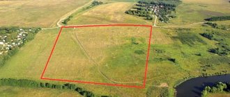
carries out topographic surveys of land plots for design, construction, gasification and utility networks. Our surveyors will help with creating a geobase or topoplan (map) of the area at the required scale: 1:100, 1:200, 1:500, 1:1000, 1:2000, 1:5000. From the company you can order topographic surveys with the application of communications on the topographic plan and other geodetic works at a competitive price in Moscow (Moscow region).
Our own equipment and the use of modern software systems allow us to make site topography for complex engineering objects with high measurement accuracy.
Topographic survey is divided according to purpose for:
- land plots;
- construction and design of buildings;
- tree-by-tree plan of the area (tree);
- topography of land plots;
- installation of utilities;
- creating topographic maps;
- carrying gas into houses;
- removal of land boundaries on the site;
- setting out points
Scales of the topographic plan and geological basis:
- 1:100 – large-scale plan for designing complex objects;
- 1:200 – construction of utility networks and communication systems in cities;
- 1:500 – drawings for residential multi-storey buildings and plots for country houses;
- 1:1000 – routes of pipelines and highways;
- 1:2000 – master plans of enterprises;
- 1:5000 – highway network projects.
We will carry out topographical survey on a turnkey basis - from the preparatory stage, carrying out field measurements in the selected coordinate system and up to desk processing of the received data on the terrain.
Why is topographic survey carried out? And what does it include?
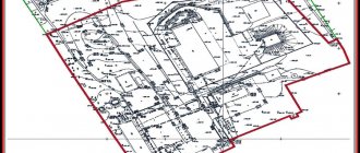
The importance of topographic surveys cannot be overestimated. Carrying out topographical work is included in the list of responsibilities of cadastral service employees. Without the necessary data characterizing the relief of a land plot, it is impossible to draw up a topographic plan. This is the name given to an image of a site taken on a reduced scale.
Topographic survey is a mandatory stage in the work of any geodetic company. Based on the results of the survey, documents are prepared, both electronic and paper. The finished plan shows the horizontal lines and elevations of the land plot.
Using topographic survey:
- establish geographical boundaries;
- prepare construction sites;
- determine the topography of the landscape.
If there is a need to carry out such work, you should use the services of surveying engineers. This is partly due to the need for special software and modern technology. Legal equipment is used only with the consent of the design services. Thanks to the well-equipped and highly professional staff, an accurate technical report will be obtained.
What is topographic survey?
Topographic survey allows you to create a detailed plan of a land plot on a certain scale, taking into account all the boundaries, structures and plantings located on it. as well as underground communications. Without completing this procedure, not a single building, engineering structure, road or any other object is erected.
Taking a topographic survey is not a whim of officials or contractors, but a legally justified basic document of all geodetic work.
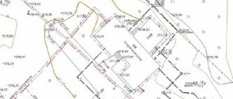
All data obtained as a result of the description of the land plot, that is, its detailed plan, is described on paper using special symbols or entered into a computer. The result of a topographic survey - a topographic plan - accurately conveys all the features of the site: above-ground (not only buildings, but also trees, roads, etc.) and underground (all communications that are out of sight). On such a map, using symbols, not only all objects are indicated, but also the distance between them and the relief features of the site itself with all existing differences.
Types of topographic survey
Topographic surveys can be of different scales (most often 1:200-1:500 is used). When determining this indicator, the goal pursued when carrying out geodetic work is taken into account. For small objects, large scales are most often chosen. This way engineers achieve higher accuracy.
The topographic plan must indicate the location of reservoirs, capital buildings, green spaces, pillars, road surfaces, underground communications and fences.
In turn, geodetic surveys are divided into subtypes. They are:
- general;
- control and executive;
- special;
- landscape;
- ground;
- large-scale;
- underground.
Each type of event differs in its methodology.
In what cases is it necessary to conduct a topographic survey of a site?
A topographic plan will be needed if:
- Construction of a residential building is about to begin on the site. Particular attention should be paid to the permitted use of the land. This information is indicated in the cadastral extract and certificate of ownership. (The dacha amnesty in the current circumstances is useless. Capital objects that were not properly recorded are considered unauthorized construction from this year);
- It is necessary to design an OKS . This abbreviation refers to capital construction projects. Topographic survey precedes obtaining a building permit. The latter is given only after the provision of project documentation;
- The owner provides communications through his plot . These include sewerage, gas, water supply and telephone. Operating central networks without the appropriate papers is illegal. The list of required documents includes a plan showing the networks of water utilities, gas services and MOEK;
- Reconstruction of communications is required . Most often this is a gasification system. Replacing parts of a gas pipeline that have exhausted their service life is the most popular service. In this case, the compiled topographic plan must meet the requirements of gas workers;
- There was a need to improve the site . Contrary to popular belief, this stage is important. Topographic survey is carried out in a complex of activities: installation of lighting sources, planting hedges, changing the landscape, laying sidewalks. Thanks to a well-thought-out plan, the use of land will become more efficient and practical;
- Registration of plot cutting and transactions for the acquisition of municipal land is underway . The administration representative must see what exactly is in a certain area. The information presented in the cadastral map may not always be reliable.
What does the owner risk when building without topographic survey?
Topographic survey is the basis of any construction. It is necessary in the vast majority of cases when it comes to land. This is an important document that represents an accurate plan of the site with all the objects on it and below it.
It is in the interests of the owner himself to have a topographical plan of the site and not to run for the last car in case of controversial issues or the need to start construction.
A topographic plan of a land plot is a very important and valuable document. Making it once and storing it in any form convenient for the owner - on electronic media or paper - will not be difficult, but it will bring a lot of benefits in practical and legislative terms.
How is topographic survey carried out?
An application for geodetic survey can be submitted during a personal visit to the cadastral service or contact these companies via the Internet.
Before starting geodetic work, the land owner must enter into an agreement with the contractor. The document signed by both parties must indicate all the conditions. Among them: cost, scope of work and deadlines.
The contract is drawn up based on the client’s wishes, as well as archival information, development plans, area maps and measurements of the territory.
We work in all districts of Moscow and the Moscow region:
Design, survey and survey work is carried out in districts (including cities in the Moscow region near Moscow) and districts.
Engineering and construction surveys on ecology, geodesy, topography and geology are carried out in areas (including cities and settlements) of the Moscow region, the city of Zelenograd, districts and regional centers of New Moscow.
What does the owner of the plot receive?
Firstly, the owner receives a ready-made cadastral plan - a digital model of the land plot, which contains a graphic and text description of the land plot. An agreement is attached to it, which, in addition to the terms of cooperation and details of the parties, contains an expert’s opinion.
The second important document: geobasis - the basic plan of the specified land plot, which is necessary for the employees of the Cadastral Service to formulate a construction project.
It is important that the resulting plan meets all the requirements that made the topographic survey necessary, otherwise the documents will not have legal force.
Stages of surveying
The specialist uses GPS navigators, tachometers, and aircraft to perform surveys on a large scale from the air. Satellite measurements can also be used. The entire process of topographic work is divided into several stages.
Filing an application
You can order a topographic survey from any company that has permission to provide such services. Measurements are taken taking into account the provisions of the Town Planning Code of the Russian Federation, Federal Law 221, orders 518, 582, SP 11-106-97.
The application is submitted at the office of the selected company or remotely on the official website. Afterwards, an agreement is concluded between the owner of the land plot and the contractor, which specifies the entire scope of work, timing and cost of completion. The wishes of the customer, data from archival documentation and existing topographic maps must be taken into account. Next, the scale of the site plan and the instruments needed for measurements are determined.
Data collection
As soon as the technical plan is approved, topographic survey of the site begins. A cadastral engineer comes to the area to begin work. The following is carried out on the site:
- determination of territory coordinates;
- geodetic measurements and fixation of coordinates on the ground;
- filming communications.
Depending on the goals, the plan can be supplemented. For example, for capital construction, a cadastral engineer is required to show the relief features on the plan, plan the verticals and horizontals of the planned construction site, etc.
Topographic survey process
During the shooting process, the information received is recorded by a specialist on electronic media. At the end, the data is transferred to the office department , which draws up a plan of the studied territory. All objects identified on the ground, linked to coordinates, are displayed on the map in accordance with the scale previously agreed upon with the customer.
The result is a digital model of the territory , which is subsequently transferred in detail to paper. This plan is included in the technical reporting in the graphic section.
Subsequently, a text is generated containing information about the land plot, as well as information about the organization that performed the work and an expert’s opinion.
Data processing
Situational plan of a land plot
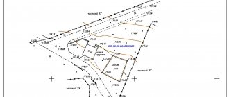
Surveying using a theodolite, which measures vertical and horizontal angles, allows you to obtain a contour map of the area. Typically, such a plan is necessary to create a situation plan on a large scale in flat terrain.
There are several known methods used when carrying out such surveys (for example, polar coordinates, angular intersection, alignments). The choice of method depends on the conditions and characteristics of the study area. The peculiarity of theodolite survey is the need to measure all objects present on the site. In this case, the relief is not taken into account. If necessary, additionally use a level.
The measurement results obtained during theodolite topography are recorded in the outline. This is a drawing (diagram) where angular and linear measurements are entered.
The created plan displays all the objects of the territory: capital structures, fences, wells, and other objects that have boundaries. They are outlined with clear contours. Fuzzy contours mark the boundaries of arable lands, forests, rivers, roads and paths.
Documents for the owner
The results of topographic surveys are valid for 2 years . But if no significant changes have occurred, it is enough to obtain an Act on the reliability of the available information from surveyors. However, the data may change as a result of a sudden change in terrain, which will require a new survey.
It is necessary to strictly observe the validity period of the drawing during the construction of apartment buildings, industrial buildings, and particularly complex structures. When it comes to private residential premises, the time frame allows the developer to use a map drawn up more than three years ago.
Large-scale construction of multi-storey buildings (residential or industrial) limits the duration of the survey in accordance with legal regulations. The developer does not have the right to use an outdated plan, otherwise he will not receive the consent of the expert commission.
To avoid refusal of permission to erect a building, the owner of the land plot must have a plan with up-to-date data on the construction site. For example, if you plan to work on an area subject to soil movement, the angle of the surface may change significantly after a few years. Therefore, it is necessary to conduct geodetic surveys and draw up a map with reliable and up-to-date information.
The need to re-study the area is discussed on an individual basis . The terms and cost of surveyor services are specified in the contract. As a result of repeated measurements, the owner receives an updated plan, allowing the project documentation to be approved without delay.