Basic Concepts
Before talking about the purpose of topographic survey, it is worth taking a closer look at its main aspects.
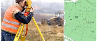
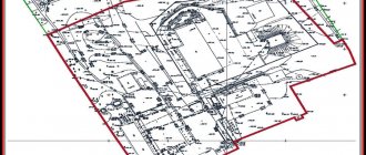
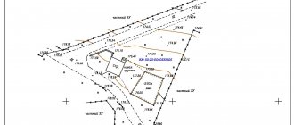
So, the result of topographic survey is a topographic plan. This is a detailed image of a site on a reduced scale. It is in great demand in the modern land market and its preparation is included in the list of services of any geodetic company. The topographic plan reflects all objects located on the site (and under communications) in a system of conventional signs indicating elevations and contour lines. Prepared in paper and electronic form.
Topographic surveys come in different scales. The choice of scale depends on the purpose of geodetic work. The smaller the scale, the larger the object of work and the less accurate and informative the plans. And vice versa - large-scale topoplans have high accuracy and a larger number of contours and objects are applied there, up to underground utilities and bushes. Accordingly, the larger the scale, the more expensive it will be to prepare a topoplan for an identical area.
In most cases, scales of 1:200-1:500 are used. They are most often needed for various construction works. Within its scale, a topographic survey of a land plot is carried out indicating permanent buildings, road networks, fences, underground utility outlets, lighting poles, green spaces, water bodies, etc.
Topographic surveys have a large number of types, which are characterized by different techniques, instruments used and accuracy. The use of each of them is dictated by the expediency of labor costs, the volume of work and the required accuracy.
Many owners or tenants of land plots ask the question, “Why do I need a topographic survey on my plot?” Or more specifically, “Do I need topographic survey for land surveying, or gas supply, for example?” The following are cases when you still need topographic survey.
Who compiles the topolans?
Answering the question of how to obtain a topographic plan of a site is quite simple if you know who draws them up. Since the document is highly specialized and requires specific information, plans of this kind are drawn up by topographic specialists, but only after geodetic surveys have been carried out on a specific piece of land. The conducted studies and their results make it possible to collect more specific information about a certain territory in order to subsequently carry out the correct design of buildings and structures, taking into account those engineering networks, communications and characteristics that already exist at certain points.
You can order such work and drawing up a plan from any company that has a state license for geodetic surveys. These same organizations carry out topographic surveys and their subsequent decoding. As a result, the applicant receives not only the necessary document, but also gets rid of the problems of registering it, which is required in a number of institutions:
- local government bodies;
- architectural departments;
- urban planning departments;
- geodetic fund;
- geodetic supervision.
Get a building permit
Not all construction requires a permit. Before you begin construction, you need to find out the permitted use established for your land plot. This is indicated, for example, in the Extract from the Unified State Register or the public cadastral map.
It is worth immediately clarifying that owners of private land plots do not need to obtain permission if you are going to build non-commercial real estate. This could be a house, barn, bathhouse, etc. In some cases, notification of the start of construction will be required.
In other cases, obtaining permission is necessary. And an integral part of the work before this will be topographic survey. It is impossible to design most objects without topography.
Registration and registration with government agencies
According to the requirements for geodetic work, the research results must be documented in the form of conclusions . They must be registered with the Architectural Bureau at the location of the shooting, before they are approved.
Scheme of work of the geodetic organization:
A company providing surveying and research services must have the appropriate license to perform such work. Only in this case can their conclusions undergo all approval procedures and be registered with the relevant authorities.
Interaction between the customer and the company is carried out on the basis of a written contract for the provision of services .
On average, the following stages :
- Conclusion of an agreement
- Departure of a team of surveyors to carry out work on the ground
- Performing surveys using special equipment
- Drawing a topographic map of the site
- Presentation of the results obtained in writing
- Payment and transfer of results to the customer
- Work on coordinating geodetic surveys
The sequence and stages can be adjusted depending on the specific conditions, goals and objectives of the customer, so the diagram is approximate.
Design capital construction facilities (CCS)
Here we will talk about buildings that require a building permit.
It's no secret that to start designing it is necessary to have data on the land plot on which construction will take place. The main source document is a topographic plan or geobase. Most often the scale is 1:500, but for large industrial facilities or facilities in sparsely populated areas it is possible to use 1:1000 and 1:2000. If you connect the design of the OKS and obtaining a construction permit, then the order is as follows: first topographic survey, then design, then obtaining a permit. The design of the future building is applied to the topographic plan and is, as it were, “tied” to the boundaries of the land plot. When planning the construction of public transport systems, the passage of various communications is almost always immediately planned.
How to do a topographic survey yourself
The area can only be assessed by a specialist who has the appropriate equipment. Only a certified plan that complies with all norms and legal requirements can be considered an official document. However, for personal needs, it is allowed to use a site plan drawn up independently . With its help, you can change the territory, for example, arrange a pond or lay paths.
What tools will you need?
To conduct a topographic survey with your own hands, you do not need a large and expensive set of tools. It is enough to have:
- weighted hammer;
- 1-2 meter wooden stakes;
- thirty-meter tape measure;
- building level;
- rope.
With such a kit, approximate measurements can be taken, so using them for capital construction is not recommended.
Carrying out work
Wooden stakes are placed in the corners of the areas - the main points. Ropes are stretched between them, which should not be too tight or sagging. The attachment point is placed a meter from the ground. You can calculate the exact distance and location using a building level.
Next, use a tape measure to measure the distance from the ground to the rope and record the results on a diagram/drawing of the area. The obtained data is then compared with the current site plan. In this case, be sure to take into account the scale of your drawing and the official map.
Bring up communications
If buildings on the site have already been built or you plan to install communications (gas, telephone, water supply, sewerage, etc.) from central networks along with the construction of the house, you again cannot do without a geological basis. Operating organizations (gas services, MOEK, water utility) will require a topographic plan with networks and other objects marked on it for the territory of the planned passage of communications from the tie-in to the entry point to the building. Often a situational plan is also needed. Topographic survey will also be needed when it is necessary to reconstruct communications on the site. Topographic survey for gasification of buildings is the most popular type of work today. Our specialists often prepare topographic plans for gas services, so they know exactly what to do and how to prepare it. It is the “gas workers” who often do not accept topographic plans from “third-party” organizations, preferring to send everyone to well-fed partners who do not hesitate to inflate prices.
What is a topographic plan
This name refers to a special-purpose graphic document. It is compiled by specialists in the field of topographic survey and geodesy. This category of land plan, just like regular terrain maps, displays certain areas of the surface. The difference is that the topographic document is done to a certain scale. The map is significantly reduced in order to accommodate as large an area as possible with minimal markings. In such an image, surface curvatures (natural differences in terrain) are not indicated in any way, but the communication networks present (passing through the site), buildings and engineering structures of any type are important. It is also mandatory to mark the boundaries of plots that are in one form or another of ownership. The document must necessarily display all technical information that affects the quality and characteristics of the site, therefore it is classified as cadastral documentation, where a detailed record of all resources within the city, district, region and country is kept.
If you compare this type of plan with a map, it is worth noting the high accuracy of the information. It displays 1 specific piece of land. Regardless of the size of the area covered, it will receive a detailed drawing with an error of no more than 10 cm.
Improve the land plot
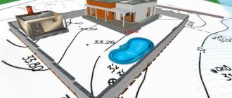
Landscaping means not only planting bushes and paving paths. This is a whole range of works, which includes the preparation of a topoplan, design and implementation of the plan. Landscaping is lighting, sidewalks and driveways, green spaces, water features, decorative fences, changing the terrain and much more, which is designed to make the use of the land more convenient and practical. For this purpose, large-scale plans of a scale of 1:200-1:500 are used. They are often called landscape topoplans. Their key feature is the indication of the location of all vegetation and an accurate reflection of the relief features. Landscape designers and design organizations use such plans. Even if you want to do a landscape project yourself, such a plan will help you avoid mistakes and inaccuracies. Even on a small plot of land, your imagination has room to roam, and a topographic plan will help with this.
Apply for an extension or buy municipal land
All these actions directly relate to the design of the layout of the land plot. Before allocating or selling a plot of land, a representative of a state or municipal body must have an idea of what is located on the property. This is why a layout diagram is required. In Moscow, the DGI prepares the diagram, and there is no talk about topographic survey there. But in the rest of Russia, as they say, some go to the forest, some go for firewood. And, although this is not provided for by law, the results of topographic surveys are often required to be applied to this diagram. That is, you can submit a scheme without it and insist that you are right, but if the administration believes that it is needed, it will not be possible to convince you. Topographic survey is necessary so as not to inadvertently allocate any driveway or pond as private property. After all, the cadastral map on which the location diagram is based does not always clearly reflect the realities of the area. As a result, we would like to advise you to ask the administration about the need for filming, so as not to waste time and extra money.
The future owner of the land should know
know that a topoplan can be useful, because there is a possibility of some communications passing through the site. This may make subsequent construction on it difficult or impossible. It turns out that the results of topographic surveys can influence the decision to purchase land.
Laws and orders
All geodetic work on the ground is carried out in strict accordance with the requirements set out in regulatory documents, the main ones being the following :
- Federal Law 122-FZ “On State Registration of Rights”
- SP 47.13330.2012 Engineering surveys for construction. Basic provisions. Updated version of SNiP 11-02-96
- SNiP 11-04-2003 “Instructions on the procedure for development, coordination, examination and approval of urban planning documentation”
- Order of the Ministry of Economic Development of the Russian Federation on approval of types of boundary signs No. 582 dated December 31, 2009; Order of the Ministry of Economic Development of the Russian Federation (Requirements) No. 518 dated August 17, 2012.
Work on land geodesy should only be carried out by specialists who have the appropriate education and work in a licensed company .
Only in this case, the results of measurements and research can be formalized in the form of documents that have full legal force.
Inventory communication networks
This type of topographic survey is more in demand by legal entities, in particular by balance holders of power lines, water pipelines, cables, etc. In essence, this is either executive shooting of new communications or shooting of old ones to clarify their quantity and location. According to the technical specifications, it is possible to indicate on the topoplan not only the communication itself with its height, but also adjacent objects with a given width from the axis.
What are the stages of creating a topoplan?
Documents with this level of accuracy and government control are not compiled in 5 minutes. The work includes several important steps:
- submitting an application for drawing up a topographic plan;
- collection of necessary documents;
- drawing up technical specifications based on the customer’s goals;
- carrying out geodetic surveys and topographic surveys;
- analysis and layout of collected information;
- translation of work results into graphic images with specialized symbols;
- state registration of the created topoplan.
Get a logging ticket
A felling ticket does not require a topographic plan as such. Because neither heights nor underground communications need to be indicated. A tree-by-tree topographic survey is required. The tree-by-tree plan will indicate all ground objects (buildings, roads, etc.) and, accordingly, trees and shrubs. All trees planned for felling or pruning are also indicated there. All this is certified by the seal of the balance holder of the territory where logging work is planned.