Why is geodetic surveying needed, and what are the parameters for it?
Geodesy of a land plot must be carried out every time it comes to:
- Reconstruction of the building.
- Construction of additional structures.
- Repair of structures or buildings.
- Construction.
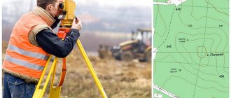
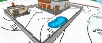
During geodetic or topographic surveys, specialists solve problems such as determining the nature of the soil of the area , assessing the landscape and calculating the exact coordinates of the future construction site. As a result, a construction or road construction organization receives a geodetic plan made on a certain scale, for example, a scale of 1:500, which will become an important basis for subsequent actions.
By the way, on our website you can find a convenient calculator for scales 1:500, 1:1000 and others.
What do pegs look like for surveying and setting out boundaries?
There are no specific requirements for pegs in the law. Surveyors use pegs made of wood or metal as boundary markers that secure boundaries on the ground. This could be a piece of reinforcement, a pipe, a wooden block, etc. Geodetic stakes are driven into the ground 30-40 cm, leaving 50-70 cm above the surface. The diameter or cross-section of the pegs is from 1 to 5 cm.
Legal basis of geodesy
The activities of surveyors, from the point of view of their compliance with legal acts, are regulated by the Constitution of the Russian Federation, the law on geodesy and cartography and some other by-laws.
Thanks to these laws, the state establishes how geodetic surveys of the area are organized, what rules should be followed during their implementation and what technical requirements must be adhered to. Most of the legal norms are approved by the state body in the field of cartography and geodesy, operating at the federal level. Subjects carrying out geodetic activities are required to comply with these standards when performing measurement work . The state supervises specialists and organizations involved in the provision of geodetic services and applies negative sanctions to violators in the form of punishments enshrined in the relevant articles and provisions of the Criminal Code and the Code of Administrative Offenses.
Cost of geodetic work
Approximate price of services provided by our company:
| for area objects | from 10,000 rub. / ha |
| for linear structures | from 30,000 rub. / ha |
| construction support | from 70,000 rub. / ha |
More detailed price list for geodetic works.
The final cost of geodetic work depends on its complexity and is agreed upon individually.
Detailed information about geodesy in Moscow and the Moscow region, our services and the specifics of the work can be obtained from specialists by calling +7-495-777-65-35, WhatsApp.
— WHY IS COOPERATION WITH US RELIABLE AND PROFITABLE? —
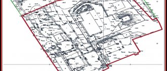
What work is performed during geodesy of a land plot?
The list below includes those works that are carried out by surveyors in the vast majority of cases, namely:
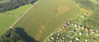
- The landscape of the area is explored and studied . In other words, it is determined whether there are hills, depressions, for example, ravines, or water bodies on the land plot.
- The area of land intended for future construction is calculated.
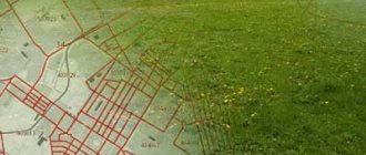
- It is determined where the site boundaries . This helps to more accurately determine the boundaries of the land intended for construction work, so as not to affect the land of others and, thus, not to violate the rights of the owners of neighboring plots of land.
- The places where the turning points .
- Surveying of objects is carried out , for example, structures or buildings already present on the site subject to geodetic survey.
- A geodesy of the utilities existing on the plot of land under study is being carried out This is done in order to take into account their location when performing further construction work, for example, in order not to cause any damage to communications.
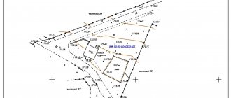
Types of filming
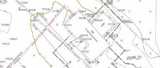
- Topographical – used to create a digital model of the site, for planning vertical buildings and designing landscape design. The heights of some points over others, the distance between them, angles are measured, the sizes of buildings, above-ground and underground networks, streets with roads and sidewalks, and green spaces are noted.
- Executive – a set of surveys aimed at comparing actual data on an object with initial information. Surveying is carried out at the time of delivery of the finished object, but this service can also be ordered during the construction process to detect violations of building codes.
- Facade – photography of the external surface of a building to determine the coordinates of the structure, the dimensions of the facade of the structure as a whole and its individual parts. Photography is in demand during the construction and reconstruction of structures, when determining the size and area of buildings, when drawing up estimates for the restoration of houses of historical significance, and when conducting construction expertise.
- Vertical - leveling, used in geodesy when considering terrain features, studies the excess of some points over others and identifying the same heights. Based on the results, the maximum and minimum height of the site, slope, and isolines with identical elevation data are determined. Vertical surveying is necessary to identify the place on the site where the building will be most stable, as well as to clarify the slope angle of the sewer or water supply route.
- Horizontal - for tracing the contours of buildings, longitudinal sections or non-standard shapes.
Price
from 12,000 rubles
Order
Tools and devices used by surveyors
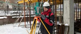
A classic device on a special tripod used by surveyors during field work, which you have probably seen more than once, is a tacheometer .
It is a tool that performs many tasks, namely: measuring heights, angles, and also the length of objects. The principle of its operation is based on optical-electronic measurement of the above parameters. Due to its versatility, it is used in most geodetic work. Another tool often used by surveyors is called a level . It is mainly used in road construction, when it is necessary to control the verticality of laid road materials, the level and height of an object, since it does an excellent job of accurately measuring the height of one object over another. There are several types of levels that differ from each other in their operating principles, for example, laser levels, optical levels, and auto-installation. An important advantage of a level over a tacheometer for some surveyors is the significantly lower purchase price of a level.
In connection with the development of communications, both satellite and fiber optic, surveyors began to apply scientific achievements to achieve the goals of precise measurement, in particular, to use satellite signals received by special GPS equipment. This allows you to achieve the highest quality measurements.
A tripod or tripod was created by geodesy specialists to perform a simple but very important function: to hold geodetic measuring instruments in a stationary state.
First, before mounting the device on a tripod, a tribrach is placed on it. This is the name of a device designed to hold a measuring instrument in a horizontal position and center it over a fulcrum. Tripods are usually made from composite materials, wood or metal. A pole is a tool to ensure correct measurements.
It looks like a rounded stick with a height of about two meters and can, like a telescopic fishing rod, extend up to six meters. The most important part of the pole is the reflector located at the top of this tool. He is engaged in returning the signal sent by the level or total station back to the measuring device. A cable and pipe detector is useful for a surveyor when he is busy searching for utilities in the area under study. Typically, this device includes a generator, the main task of which is to create sound vibrations on the visible part of the pipe or cable, so that the cable and pipe detector can calculate how the underground part of the communications passes with an accuracy of five centimeters. Then the research results are reflected on a geological basis.
Stages of geodetic work during land development in Moscow
Engineering surveys are carried out in three stages:
- Preparatory – obtaining technical specifications, concluding a contract for work, collecting and analyzing available materials from past surveys, determining the scope of work in accordance with the technical specifications, issuing permits to conduct surveys.
- Field – reconnaissance, surveying geodetic networks, carrying out the necessary measurements and calculations, preliminary processing of the results;
- Desk – compiling or updating a topographic survey, coordinating communications, drawing up a technical report and transferring it to the customer.
The cost of geodetic work is calculated individually and depends on the volume and complexity of the work. To order geodetic surveys, you can leave a request on the website, call us at +7-495-777-65-35 or request a call back - Request a call.
Geodetic survey report in pdf format
Look
What do surveyors do during a geodetic survey?
Main responsibilities
According to legislative norms, the participation of surveyors in the future construction of an object is not limited to the direct implementation of geodetic surveys. They are required to do a whole range of actions that precede the shooting, and are also carried out after it:
- Studying a construction project . At this stage, specialists read design documents, get acquainted with the features of the future building, and develop a plan for the future geodesy of the facility. To put this briefly, surveyors conduct a preliminary examination of the object of their subsequent work.
- At the second stage, the geodetic survey , during which the landscape and other features of the land plot are examined, which can have a significant impact on the construction process and lead to changes in plans. Specialists should also check the land plot for the presence of abandoned or unknown communications, for example, heating or water pipes, and check whether there are any unused structures on the site. After the survey, the construction plans are adjusted, and a control final geodetic survey is carried out, with the goal of clarifying and verifying the results obtained, on the basis of which a plan of the land plot will be developed with all the necessary coordinates necessary for the successful completion of the construction of the facility.
Additional Responsibilities
Other duties performed by surveyors include their participation in the examination of future construction sites, when they can, thanks to their experience in the field, point out errors in design, for example, the mistakes of an architect who does not take into account the nature of the soil of the area, which is very an important parameter in geodesy, and designs a building from materials that may have their performance degraded due to construction on unsuitable soil. Specialist surveyors can also accompany the construction and installation process, namely: tell workers where communications need to be laid and where it is necessary to strengthen the land slopes.
Required documents
Each stage of engineering geodesy must be accompanied by certain permitting documents. Work is possible if:
- Technical specifications, including complete information about the features and location of the survey area, the adopted coordinate system and the timing of the study.
- Contracts for carrying out engineering geodesy. Where the area of the territory to be surveyed, the scope of work, the timing and cost of the survey are determined.
- Materials of previously completed studies, if available (topographic maps, plans, results of previous geodetic surveys, etc.)
- A survey program, including a description of survey methods, diagrams for constructing a geodetic network, as well as a list of SNiP standards.