Federal laws No. 221-FZ and No. 447-FZ regulate all the nuances of cadastral activities in our country.
The first one was adopted in 2007, the latest changes were made not so long ago.
The second contains changes and additions to this law, the most significant of which is the chapter on complex cadastral works.
It was adopted in 2014 and amended in 2021.
Federal Law on Land Surveying, Dacha and Garden Plots: Basic Definitions
There is no separate regulatory legal act regulating exclusively the provisions on land surveying in the Russian Federation.
The law on land surveying in the Russian Federation can be called the Land Code; it was adopted in January 2001. The Code consists of chapters and articles. It reflects the main provisions regarding the delimitation process, the state cadastre, the rights and obligations of a separate group of persons.
Legislation on land surveying activities also includes the basic concepts that must be used in this process:
- Land surveying is the establishment and registration of boundaries on a piece of your land.
- Boundary – the boundary of land holdings.
- Ownership of land is the ability to own, use and dispose of it.
- Horticultural lands are lands not intended for individual housing construction, but adapted for growing fruit and vegetable crops.
- Interleaving is repeated surveying, which is carried out by a specially authorized person already in the demarcated area in order to clarify certain information.
- PDO – public lands.
This is not the entire list of concepts used in this procedure, but they are the main ones and are most often used.
What is land surveying under the new law?
The new federal legislation of 2021 (Federal Law 477) established that citizens have the opportunity to carry out the land surveying procedure free of charge. This applies to persons who live in certain regions. This Federal Law came into force on December 29, 2014.
The program list includes the following regions:
- Stavropol.
- Sevastopol.
- Perm region.
- Kamchatka Krai.
- Amur region, etc.
Land surveying occurs in five stages, each of which has its own distinctive features, which will be discussed later.
Cadastral number
A cadastral number is a unique numeric value that allows each individual plot of land to be identified on a public cadastral map.
In order to determine the cadastral number, you can refer to the following sources: purchase and sale agreement; land title document; cadastral passport. To determine the cadastral number, you can also refer to the data contained in the regional Rosreestr. Since today all databases are united, you can obtain information about land located in any region of the Russian Federation.
You can now get a tax deduction for your dacha
Traditionally, the new year brings with it not only children's matinees and an increase in utility tariffs, but also new rules and laws that begin to work on January 1. There are also interesting prospects that are expected to be adopted during the coming year. Real Time provides a brief overview of the most important changes coming in 2021.
Extension of the dacha amnesty with some changes
Now imagine how convenient it will be to order KKR for, for example, your SNT or DNT. Firstly, the possibility of the borders of neighboring areas “colliding” with each other will be excluded. Secondly, in the case of a collective order, the price of land surveying and cadastral work on the site will decrease, according to some experts, by up to 10 times. Thirdly, Rosreestr will also receive its “buns” from this, on the map of which the old “white spots” will disappear. In general, solid preferences.
Land surveying is an extremely important and responsible event, on which subsequent cadastral registration and state registration of land rights depend. The compliance of the finished boundary documentation with the requirements of the law depends on the qualifications and experience of the cadastral engineer.
The survey file is subject to approval after its formation, and then sent to the state archive for storage. In case of changes in information about the site, which required additional survey work, changes are also made to the survey file.
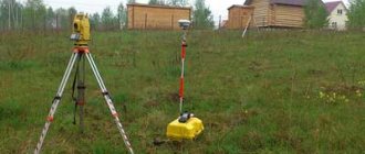
Surveying
During land surveying, the boundaries and area of the land plot are determined. It is this data that is of practical importance when making transactions with land and drawing up purchase and sale agreements, leases, etc. Having the information obtained during land surveying, the owner will always be able to distinguish his plot from neighboring ones, as well as use various ways to protect his rights.
The owner is obliged to carry out land surveying in order to be able to dispose of his land. Until December 31, 2021, this was voluntary, but has now become mandatory. At least for those owners who would like to sell their plot, or donate it, or start construction on it, or simply leave it as an inheritance to their children.
Land surveying procedure
The land surveying procedure essentially consists of several stages.
By virtue of the law, the owner must enter into an agreement with a company licensed to perform the procedure . The contract also determines the cost of the work. It is necessary to demarcate the site according to the rules provided for by Russian legislation.
This was the first stage of the procedure.
As for the second stage , here you need to collect the necessary documents. Their list includes the following acts:
- owner's passport;
- certificate of ownership;
- consent of neighbors if the site is located at the intersection with another;
- acts on the absence or presence of communications on the site.
The geodetic service has no right to require any other documents.
The third step is to notify neighbors in the area about the relevant work. Such notification must occur within a period not exceeding seven days, otherwise, neighbors have the right to demand the cessation of this type of work.
For a separate price, a surveying company can also take care of the notification issue. The concept and definition of the notification procedure in this case must be spelled out in the contract itself.
The fourth step is the arrival of employees of a geodetic company to the site to carry out the necessary measurements, determine the boundaries of land plots and sign control acts. At this moment, the price under the contract, as provided initially, cannot be increased.
It is necessary to carefully read the text of the drafted act, since it is on this basis that the boundary plan will be prepared. This applies to garden plots in SNT, and for summer cottages. The terms for land surveying established in the contract must also not be violated.
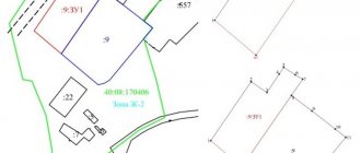
The end of this procedure is the fifth stage. After the last necessary actions have been carried out, the execution of the contract is marked by the publication of a special act - a boundary plan. It is necessary when registering land ownership and carrying out other legally significant actions with the land.
Who needs to do land surveying according to the new law
The new law obliges all those persons who occupy land plots for the corresponding purpose to carry out the land surveying procedure.
As a rule, land must be demarcated when it is subject to subsequent sale. In the absence of land surveying, many legally significant actions with the land will not be possible. Of course, if the land has already been demarcated, then there is no need to repeat this procedure. We are talking only about those areas for which there is no data in the public cadastral map. In some regions of the Russian Federation, this procedure is free, as mentioned above.
Price
Land surveying services are not cheap for the site owner. Prices vary greatly depending on :
- region;
- squares;
- outlines of the site;
- distance from the city.
On average, the price for the services of a cadastral engineer to survey a garden plot of 6 acres will cost 10 thousand rubles . If the configuration of the plot is correct, the plot is located within the city, then the price can be about 5 thousand .
But pensioners often do not have even this amount. Therefore, you need to approach the issue of land surveying rationally. If you have received a cadastral passport and registered ownership of the garden plot, then you can sell your plot without land surveying. Another question is whether it will be in demand.
However, on various Internet platforms, rumors are now persistently spreading about mandatory land surveying and the absence of deferment, as evidence of which Federal Law No. 477 is cited. This law is presented incorrectly; it refers to changes in the Tax Code, and not the state cadastre.
The news is also erroneous; there is no article in the legislation obliging the determination of the boundaries of the site.
Who does land surveying for free: new law
You can count on free surveying by contacting state geodetic companies.
Among other things, in each region a list of private firms is formed that operate on the basis of a state or municipal contract. In such organizations it is also possible to demarcate land for free.
How to order land surveying for free
In order to place an order, you must contact the state surveying company or the city administration in order to indicate your right to carry out the survey procedure free of charge.
Deadlines for land surveying according to law
As a rule, the terms of surveying procedures are prescribed in the contract with the geodetic company, however, at the legislative level there are time limits.
Thus, land surveying work must be completed within a period not exceeding five days, and completed documents must be issued within a period not exceeding two weeks. Another thing is with land registration. Here the procedure may take a month.
How to arrange land surveying
Land surveying is formalized by issuing a special act called a land survey plan. It is in it that the boundaries of the land plot, its location on the public geodetic map and other essential information are clearly stated.
What to do after land surveying
It all depends on whether the right to your land plot is registered or not. In the event that registration has not taken place, then the boundary plan will serve as the basis for registration.
Also, without a boundary plan, it is impossible to carry out the purchase and sale of land.
What lands should be surveyed?
Despite the fact that people hoped that the new law would not apply to garden areas, a similar condition is still relevant in this case.
It turns out that the procedure is recommended for owners of any type of land that is officially owned. Why does such a serious decision have official status? Initially, it is important to note that in the Russian Federation there are indeed many land plots occupied by capital structures that have not undergone official registration. That is, no one paid land tax from them. Just count that in the Moscow region over the past year there were about 600 thousand of them, and in the state the figure will be definitely higher.
Most of the land belongs to gardening partnerships, vegetable gardens, dacha cooperatives, and was issued to company representatives back in Soviet and post-Soviet times. Only those owners who have drawn up documents in the past and have the corresponding act in their hands can not worry about the need to draw the boundaries of the territory. If you do not have this document stored in the archives, or you recently purchased the land, you need to request an extract from the state register for the territory, and based on its results, make a decision whether the procedure is required or not.
Sale of land without land surveying
There were rumors in the legal community that if the land plot is not demarcated, then it is impossible to sell it.
Indeed, few buyers will agree to purchase such a plot on the condition that he will have to carry out all the legal procedures himself. However, there is no direct legal prohibition on this. It is impossible to invalidate a contract on the grounds of lack of land surveying.
But it must be borne in mind that legislators have long wanted to limit the actions of citizens in the purchase and sale of undemarcated land. Changes to legislation may come into force at any time.
Download the federal law on land surveying, summer cottages and garden plots
You can download the latest version of the law with amendments and additions right here. ⇐
So, to summarize: actions with land are legal only after the land surveying procedure. You can order a boundary plan in accordance with Federal Law No. 221 from authorized companies.
Only accredited companies or government entities can carry out the procedure for delimiting your site and make its plan. Information about whether land surveying was carried out and what cadastral number of the land is available on the Rosreestr website. The obligation to carry out this procedure is not established by law.