Establishing ownership of land involves a mandatory procedure for land surveying.
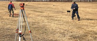
The specifics of marking boundaries are based on the use of geodetic instruments , which may provide some error.
The difficult terrain only makes the situation worse.
As a result, this can lead to serious consequences and controversial situations with the cadastral service.
The importance of defining land boundaries
Land surveying is engineering and geodetic work to establish and determine the boundaries and area of the site, followed by legal registration of the relevant documents, incl. cadastral number.
From 01.01.2021, the absence of a cadastral number from the Unified State Register of Real Estate completely excludes the possibility of selling, donating or inheriting a land plot.
The documents must accurately indicate information about the boundaries of the land plot and its geometric shape.
In the absence of clearly established boundaries, the owner may have difficulties concluding legal transactions , namely:
- Division of land if it is necessary to sell, inherit or donate one of its parts;
- Purchasing land plots, especially in densely populated areas, since there is a risk of seizing someone else’s territory;
- Using land as collateral when it is necessary to obtain a loan from a bank.
In addition, there is always a risk of disputes with neighbors or the municipality regarding the appropriation of part of the territory.
What are the coordinates of the land boundary
The main characteristic of a site is the coordinates of the site, and not the length of the boundaries.
It is the coordinates that determine the characteristics of an object in space, its position on the ground.
The coordinates provide access to the site code, its cadastral number.
The reference point for determining the coordinates of characteristic points is the reference boundary network.
To calculate the position of characteristic points and boundaries of the site, satellite, analytical, photographic, polygonometric, and cartometric methods are used.
Geodetic basis
Land surveying is carried out in accordance with accepted national, general and conventional coordinate systems.
In this case, reference boundary marks (RBS) serve as initial data for :
- To consolidate the local coordinate system and link it to the national one;
- Restoring lost boundary signs and solving other problems regarding the land cadastre.
Simply put, the geodetic basis for land surveying serves for surveyors to establish the boundaries of land ownership in relation to certain reference points of local or even national significance . It is on the basis of these measurements that the land plot is assigned a cadastral number.
Basic boundary markers are
points of varying degrees of national importance .
Based on these points, measurements are taken and the boundaries of the site are superimposed on the national coordinate system.
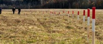
Physically, they most often look like built-in metal pipes.
The more complex the terrain of the land plot, the greater the permissible error during land surveying.
The measurement engineer's job is to accurately carry out physical calculations in accordance with the turning points marked in the digital coordinate system.
How are discrepancies reduced?
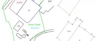
The location of the boundaries is noted in real estate documents and in the State Cadastre.
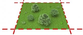
On the ground, they can be indicated by fences or natural obstacles (ravines, rivers, etc.).
If there are inaccuracies in their determination, cadastral work must be carried out.
It is necessary to specify the accuracy of determining coordinates during land surveying if the location of the site according to documents and in reality does not coincide.
Attention! Sometimes it turns out that the actual location of turning points on the ground is further from the documented ones than the error allows. Then it turns out that they actually have different coordinates.
Accuracy requirements
After designating the turning points, the boundaries of the site are drawn in the form of straight lines . Any irregularities or the presence of vegetation complicate the process of laying straight lines. The human factor and malfunction of measuring instruments cannot be ruled out.
The new calculated area and the boundaries specified on it cannot exceed the indicators specified in the cadastral document of the land plot by more than the norms established by law.
The amount of discrepancy can be reduced at the discretion of local authorities up to two times , depending on the situation in the region.
On large areas, such as agricultural land, it is quite difficult to draw the contours of the land. For this reason, there is an established permissible error rate and requirements for the accuracy of instruments.
After the study, the engineer is obliged to coordinate the boundaries with the owners of neighboring plots at a special meeting. All participants must be notified in writing. All notices are given against a personal signature.
If neighbors are absent, a notice is published in the local media. This procedure can be undertaken by the surveying company or the owner of the site.
To obtain approval, all participants in the meeting must be notified in advance that a boundary determination procedure will be carried out.
The minimum period is 30 calendar days before the measurements are taken .
The result of the work is a compiled land management file, which is transferred to the land management organization for approval of the boundary plan.
What errors can there be on the cadastral map?
This question often arises among clients when accessing a public map online. For example, how to determine whether a plot of land is located at the beginning or end of a street?
Let us clarify that the public map refers to reference resources. Accurate, up-to-date information is indicated in the USRN extract.
There are many duplicate sites on the Internet whose goal is to get money for dubious documents. There is only one official map, you can go to it from the Rosreestr website.
In life, the boundaries of the cadastral quarter do not always coincide with the boundaries of the SNT. The reason is the error of the cadastral map .
For example, our clients observed such a situation on the public cadastral map. When the background from space photographs was turned on, the area shifted by several meters.
Coordinates on paper plans or a public map may differ from the measurements of a cadastral engineer, especially when it comes to documents issued before 2010.
The reason is measurement error, the norms of which are established in legislation.
The error occurs for the following reasons:
- Features of the terrain: unevenness, ravines.
- Climatic conditions: gusts of wind, heavy precipitation, abnormal heat
- Inaccuracy of measuring instruments: untimely verification, influence of magnetic field
- Human factor: fatigue, ill health.
The error calculation is carried out on the basis of the survey justification point. It looks like this. The cadastral engineer installs the equipment at a certain point on the site. Uneven areas can cause the point to shift and increase the overall error. Therefore, in the documents this point is indicated as a survey justification point and is used for calculations.
The device, regardless of its design, distorts the readings, which may vary among different specialists.
What is error?
After taking measurements, the cadastral engineer calculates the error, which depends on :
- Characteristics of the measured territory;
- Weather conditions at the time of measurements;
- The level of training of the specialist and his work experience;
- Actual number of measurements;
- States of measuring instruments;
- Method for calculating the actual error;
- The actual distance of the site points from the OMZ.
The calculation is carried out using special formulas, one of three existing methods :
- Diagonal method;
- Permissible error method;
- Root mean square error method.
What does the law say about errors?
Issues of accuracy and error of measurements during land surveying are discussed in detail in Order of the Ministry of Economic Development No. 518 dated 08/12/12 “Requirements for accuracy and methods for determining the coordinates of characteristic points of land boundaries” and in “Methodological guidelines for land surveying” (letter of Roszemkadastre dated 04/18/03) .
Unfortunately, it happens that new provisions of the law cancel previous ones. It is sometimes very difficult to track their relevance and understand which of them apply in your case.
The state protects the rights of the owner in those contours that are reflected in cadastral registration. That is why it is so important to determine the boundaries of the allotment. If they were installed, then the documents indicate the coordinates of the points along the boundaries. In controversial situations, this is interpreted as a cartographer's error. This also happens. Therefore, we advise you to contact certified cadastral engineers. They deal with such requests every day and know the procedures for resolving such problems. For example, what to do with the practical accuracy of the boundaries in your SNT, where the zero quarter is indicated.
Any questions? Ask our specialists by phone or in the form on the website. This consultation is completely free for you.
What maximum deviations are allowed?
Land legislation establishes the maximum permissible miscalculation when surveying land plots.
Standards are mandatory for each type of settlement and purpose of the landfill.
The permissible error when surveying land plots may vary depending on the type, category and intended purpose of the land.
| Type of land | Legal norms, m |
| For lands of populated areas | 0,1 |
| For agricultural lands in the categories of individual housing construction, private plots, horticulture and truck farming | 0,2 |
| For agricultural lands of other categories | 2,5 |
| For specially protected objects | 0,5 |
| For water and forest resources, reserve lands and special purposes | 5,0 |
Allowable area method
So, calling on a surveyor for help or remembering a school geometry course, we independently determined the actual area of the land plot P(fact) and realized that it did not correspond to the cadastral P(doc) . We find the difference ∆P P(add) for your area , which is calculated by the formula:
P(add) = 3.5*Mt*√P(doc).
If ∆P is less than or equal to P(add) , then everything is in order!
For example: The cadastral area of the individual housing construction plot is 1200 square meters (12 acres). During actual measurements, it was found that the real area is 1180 square meters, that is, the difference is 20 square meters. It's a shame, but let's find out if we have grounds for legal action. Let's find the permissible deviation: P(extra) = 3.5*0.1*√1200 = 12.12 square meters. Thus, it is obvious that the actual boundaries of your site need clarification.
Calculation examples
Let's consider a situation in which the owner of a land plot clarifies the boundaries in order to check the exact footage of the area and determine the boundaries of the land plot.
He has an extract from the state cadastre, which indicates that the maximum permissible error for a land plot measuring 663 m has reached 11.6 square meters. meters. Land surveying was carried out in 2002. After which the site was registered with Rosreestr. Since the event to clarify the boundaries, the maximum permissible standards have changed.
Engineers, when visiting the site, carried out the necessary measurements.
As a result, the difference between the land plot area according to certificates and the actual area after clarification (that is, ∆Р) reached 3.4 m. The Mt indicator for agricultural land is 0.2 m.
3.4*0.20*√663=17.5 sq. m.
The obtained result does not exceed the error standards from the cadastral extract (11.6 sq. m.).
We can conclude that the information previously recorded in the state cadastre is correct and cannot be changed in 2021. The existing error is acceptable for this category of land.
Turning points
The land plot must have a certain configuration, simple or complex. The area is not always a square or rectangle with 90-degree angles - in many cases these angles can be different, which makes measurements more difficult. All places where the direction changes must be recorded - they will be called turning points.
They are easy to identify on the boundary plan, and it is by them that the position of the site is determined, and its boundaries are drawn from point to point. The cost of land surveying depends on their quantity, which means that the simpler the site is in shape, the cheaper it is to survey it. After all, to measure a simple quadrilateral, only 4 turning points are required, and if the shape of the area is more complex and it has bends, then the number of points to measure increases with each subsequent one.
Legal regulation
The issue of land surveying is regulated by Federal Law No. 218 “On State Registration of Real Estate”, and details related to measurement methods and error calculation formulas are indicated in Order No. 90 of the Ministry of Economic Development (referenced by Article 22.13 of Federal Law No. 218).
In addition to those listed, there are also other legislative acts and instructions regulating the details of the land surveying procedure in general, the use of various techniques and other nuances related to land surveying and land rights. In addition to the federal level, they can also operate at the regional level. But usually all these legislative acts are of interest to the performers of the work, who will have to take them into account, and not to the owners ordering the land survey.
Determining coordinates
It is very important to correctly set the turning points - in fact, this is a key part of the land surveying procedure, because the accuracy of measuring the site largely depends on this. To accurately determine their coordinates, various types of surveys can be used: satellite, geodetic, cartometric, photogrammetric, analytical.
Establishing the coordinates of turning points must be carried out in situ. After the required calculations have been carried out and their results have been agreed upon, the engineer sets milestones and draws lines through which boundaries can be set.