A prerequisite for the development of land allocated for the construction of objects is the correct execution of urban planning documentation. Without it, it is impossible to begin developing the territory assigned to the future object. specializes in providing a full range of services for the preparation of construction documentation, which includes the preparation of the State Construction Document.
Urban planning documentation
- materials for planning the development of an urban area, highlighting individual residential areas, microdistricts, blocks, buildings, structures and other elements of the future layout of the city, defining the boundaries of land and establishing information about their planned development. Registration of urban planning documentation includes the development of planning and land surveying projects and the preparation of state planning documents.
What is included in urban planning documentation
The package includes materials reflecting plans for the development of the urban area and providing for:
- allocation of residential areas;
- definition of neighborhoods;
- allocation of neighborhoods;
- determining the location of each building, structure and other elements of future infrastructure.
Registration of urban planning documentation also involves determining the boundaries of land for future development, as well as providing general information about the objects (functional purpose, restrictions on density and height of development, etc.) that are planned to be built.
To compile a package of documents, the following is required:
- implementation of the territory planning project;
- preparation of documentation for land surveying;
- registration of GPZU.
After drawing up these documents, customers and developers can proceed to the next stages of projects, including obtaining a construction permit.
VALIDITY
As of July 1, 2021, changes have been made to the law regarding the registration and validity of the GPZU. Now the urban development plan is valid for up to 3 years from the date of issue until the day the application is submitted to the authorized body. At the end of this period, the information specified in the GPZU cannot be used by the construction company to construct objects on the site. If construction has not started within the specified period, you will have to obtain a plan again. However, construction and design conditions may change.
Main stages and rules for preparing urban planning documents
The developer or owner of the site must follow the basic procedure for preparing town planning documents, including obtaining a town plan for the land plot. This will save significant time by getting the desired result the first time.
1. The initial stage is the preparation of territorial planning projects (PPT). Only specialized organizations can deal with this issue. The authority of the executing companies is confirmed by certificates of their presence in the SRO. Registration of urban planning documentation with the involvement of unauthorized persons is a violation.
2. The next stage is the preparation of projects for land surveying. This work can only be entrusted to private cadastral engineers registered as individual entrepreneurs, or employees of companies that have all the necessary permits and licenses. As part of land allocation measures, territories intended for new development are allocated.
3. Obtaining an urban planning plan for a land plot is the last stage of preparing urban planning documentation. Both the legal owner of the land plot and his authorized representative have the right to apply for a GPZU. Obtaining a GPZU is allowed for both empty and built-up plots. GPZU is prepared in the form approved by the Order of the Ministry of Construction and Housing and Communal Services of the Russian Federation dated June 6, 2021. No. 400/pr “On approval of the form of urban planning plan for a land plot” and is approved by the authorized executive body.
WHAT DOES THE GROUND OF LAND LOOK LIKE?
The paper is drawn up in the prescribed form (PP number 87), which indicates the current design standards, taking into account current acts and laws. The documentation is completed in paper or electronic form, in the form of text and a plan-drawing, prepared in compliance with the scale of the territory and designations adopted at the legislative level.
The text version is an explanatory note, which is also drawn up in a special form. If you know what the GPZU of a land plot looks like from the legal perspective, you can eliminate time delays and check the document after registration. It also includes acts of coordination with various authorities. In general, the structural content is divided into two components - a topographic plan and textual documentation with explanations.
Why is a GPZU required?
The presence of this document is one of the mandatory requirements when developing design documentation for the planned work. Obtaining an urban planning plan for a land plot is also required before carrying out the reconstruction of finished buildings and structures.
The presence of a GPZU is necessary at the following stages:
- preparation of project documentation;
- carrying out construction examinations;
- obtaining a construction permit;
- obtaining acts confirming the right to put a new facility into operation.
HOW TO FIND OUT THE GPZU NUMBER?
According to the law, the urban development plan must be numbered. The number is assigned after approval of the documentation by the authorized body and consists of two elements (A-B):
- A - registration number, which is individual for each municipal formation. It consists of 10 characters.
- B is the GPZU serial number, consisting of 16 characters.
To find out the GPZU number, you need to look at the certificate of entry of information about the GPZU into the state register, as well as at the stamp (entered into the electronic database).
The absence of a GPZU will be the basis for refusal to issue the necessary approvals.
It is important for the customer and developer to closely monitor the implementation of the GPZU parameters. Different characteristics in it and in the design and estimate documentation will lead to significant complications, which will result in an increase in the cost of the project and a delay in the start of work. Obtaining a building permit will be delayed until corrections are made and will incur additional costs. If a completed facility does not meet the parameters set out in the State Property Planning Plan, the developer will not be able to put it into operation. The costs of additional work may make the project unprofitable.
Obtaining a GPZU allows you to assess all financial and legal risks associated with the possible implementation of the project and make a decision on further work on the construction or reconstruction of buildings and structures.
The SEVERIN DEVELOPMENT® company assists clients in drawing up urban planning plans for land plots. The service is provided as part of comprehensive support for construction projects.
DATE FOR PREPARATION OF GPZU
Since the beginning of July 2021, changes have been made to the legislation, according to which the period for preparing a plan has decreased from 30 to 20 days from the moment the application is filled out and submitted along with documentation for consideration by the authorized authority. As a rule, it takes more time to collect the necessary package of papers. It is worth avoiding mistakes when filling out an application, which often lead to a slowdown in the process of obtaining a GPZU.
If problems arise with some categories of memory, litigation cannot be avoided, which also extends the time frame for processing paperwork. Documentation is issued free of charge.
Common reasons for refusal to provide a plan are the invalidity of the submitted documentation, the inability to read information from the application, and the absence of certain documents (for example, a passport). That is why it is recommended to check all components of the package before submitting the application and documentation.
FINAL STEPS
Once the bureaucratic red tape is over and the necessary documents are in hand, you can begin construction activities. At the initial stage, it is important to take care of such issues as installing a fence and toilet, temporary supply of water and electricity. Without solving such problems, it will not be possible to begin construction. After the building is erected, all that remains is to put it into operation. This is possible if the following simple conditions are met:
- The presence of a permanent staircase (if there are 2 or more floors). It is important that it is of a capital nature and not an added one.
- The presence of a closed-type thermal circuit. In particular, the house must have doors, a roof, a floor, windows and other permanent structural elements.
- The presence of an equipped kitchen with a sink and stove.
If the conditions discussed above are met, the house can be classified as residential. The final stage is assigning an address to the object, after which you can register and perform other actions in it.
List of documents
In addition to the application, several more papers must be submitted to receive the GPZU. An individual must attach copies of a passport and documents confirming ownership, as well as an extract from the cadastre, which can be obtained from Rosreestr. For legal entities, the list of required documents is longer.
In addition to those listed above, you may need:
- Statutory documents and changes therein;
- Certificate of property registration and registration;
- If any structures have already been built on the land, title documents and cadastral passports are needed;
- Agreements with companies organizing communications on the site;
- Power of attorney for a representative, certified by a notary;
- Copies of all listed documents.
conclusions
Thus, we can conclude that the preparation of the GPZU is a necessary procedure in the process of constructing a new building. This type of activity causes certain difficulties due to the need for a detailed analysis of the land plot, maximum clarification of its boundaries, as well as taking into account the characteristics of each structure being built. If the GPZU is drawn up in violation of urban planning regulations, then not only will the safety level of the structure be low, but it will also be difficult to properly control the construction process itself.
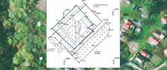
Contents of the plan
The form and content of the GPZU are strictly regulated. In its structure, the document includes a topographic plan of the site, as well as a text document. The site plan drawing must indicate:
- Boundaries of a plot of land;
- Red lines;
- Buildings for municipal and state needs (if any);
- Zoning boundaries;
- Location of engineering facilities and communication lines.
Article 44 of the Town Planning Code regulates the main provisions relating to GPZU (see link above). Thus, the legislation establishes that in order to determine the places where the construction of new structures is allowed, the owner of the site should indicate the minimum setbacks from the boundary of the land plot.
An indication of the town planning regulations is also a legal requirement. This regulation should contain information about the procedure and types of permitted land use.
If the land plot was provided to satisfy municipal or state needs, then urban planning regulations in this case will not be necessary. For plots of land, the use of which is not fixed by urban planning regulations, the GPZU indicates information about the types of permitted use of the land plot and the parameters of the structures on it.
Capital construction projects, along with cultural heritage sites, must be displayed in the plan. The text of the plan must reflect data on the engineering and technical support of the construction site.
GENERAL PROVISIONS
To avoid difficulties in design, it is important to understand a simple thing. Any action aimed at constructing a facility must begin with paperwork. If a person neglects this requirement, he will inevitably encounter difficulties. To begin with, we deal with the boundaries of the land plot (we carry out land surveying). Thanks to such procedures, it is possible to avoid difficulties with neighbors. Ideally, the site should be privatized and have a ready-made land survey plan.
Land surveying involves fixing the boundaries of the land plot, determining its “quadrature”, establishing the location of the land plot and legal registration of papers for a specific territory. The following organizations can help with resolving the land surveying issue: real estate agencies, CIS chairmen, surveying firms and BTI employees. This action is necessary if there is a risk of losing a plot of land, difficulties in registering an inheritance, or a desire to receive an abandoned plot.
Land surveying is carried out in several steps - documentation is prepared, an agreement is drawn up with the survey company, and then the papers are transferred to the cadastral chamber. Further, the documentation is used for state registration.
Many people, in order to eliminate bureaucratic difficulties, entrust the work to a construction company. A special organization independently resolves issues of a “paper” nature, charging a fee from the client. This approach is convenient and requires large financial investments, so if you want to save money, it is better to go through all the activities yourself.