Rules for the formation of land plots in 2021
In accordance with the Land Code (Article 11.2), there are several ways for new land plots to arise. This is how the general rules for the formation of land plots sound in 2021:
- Selecting one, or vice versa, combining several areas
- Redistribution of land plots
- Section (one area is divided into several)
But we will focus on the formation of land plots through redistribution. Let us clarify the procedure and procedure for redistributing land in 2021. We will also find out where to apply and what documents should be collected.
Sanctions for illegal land seizure
Cases of illegal seizure of land are established by Art. 7.1 Code of Administrative Offences. If fraudulent aspects are identified, the case may fall under the criminal code. With this option, the offense faces much more serious consequences than just a fine and seizure of the site. In the absence of fraudulent activity, the violator will most likely pay a fine. Its size depends on several factors:
- whether the plot is registered in the cadastral register;
- What is the estimated value of this plot of land?
When there is a need for redistribution of land plots
The need for redistribution of land arises for various reasons. Most often, the owner addresses this issue when a problem arises that can be conveniently solved by redistributing land plots. For example, a broken border line; wedging of adjacent areas; communications supply; inconvenient approach or entrance; a house that has already been built goes beyond the maximum permissible boundaries of the fence. After all, in essence, redistribution of the area of land plots is a procedure for combining them and then dividing them. That is, the redistribution was created for the convenience of owners in order to eliminate additional red tape with documents.
The owner of a land plot can, by redistributing land plots, add to the land plot at the expense of adjacent lands and increase its area.
Instead of a conclusion, or Putin’s opinion on the addition of a plot of land
Vladimir Putin allowed Russians to register surplus land. This benefits both the state and the ordinary citizen. By signing 150-FZ dated June 17, 2019 (the law came into force on September 16, 2019), the president thereby expressed his opinion on the appropriation of land plots and confirmed the need to simplify cadastral work, which, according to the deputy head of the cadastral chamber, Marina Semenova, will have a positive impact on land owners. The registered plots will now officially be the property of citizens - which will increase revenues to the treasury through land taxes, and citizens, in turn, will be able to own plots not only in kind, but also legally.
The main two options for redistribution of land plots
- The owners of the plots are individuals or legal entities.
In this case, interested parties need to carry out a set of cadastral works and sign an agreement among themselves on the redistribution of land plots.
- The owners, on the one hand, are an individual/legal entity, and on the other, a municipal entity.
The most common, but also more complex procedure. Includes coordination of the design redistribution scheme with the architecture department of the municipality.
Features of the redistribution of land plots from January 1, 2021
What are the features of the redistribution of land plots from January 1, 2021? According to the law, summer cottage plots cannot be redistributed. But this is only due to the fact that the concept of a summer cottage plot has been abolished since 2021 and replaced with a garden plot. Other innovations in legislation concern general changes in the cadastre system. They are associated with the entry into force of Law 150-FZ on September 16, 2019 (dated June 17, 2019), which provides for a new procedure for comprehensive cadastral work to coordinate the boundaries of SNT land plots, public areas and other areas owned by citizens. What happens as a result of the redistribution of land between owners? Everything is simple - a new section (sections) arises, with different coordinates and area. As for the cadastral number - whether it will be changed or not, this will be decided by the cadastral chamber.
New law on land acquisition 2021
Laws in the field of land management and cadastre have undergone active changes in recent years. The new law on the addition of land plots, effective in 2021, is a whole layer of rules affecting the formation of land plots. At the beginning of 2019, Federal Law 217 on horticulture came into force, changing the basic concepts and definitions of summer cottages. On June 17, 2021, a new law 150-FZ was adopted, amending the laws on cadastral activities and real estate registration (218-FZ and 221-FZ). The changes concern complex cadastral works: the procedure for carrying them out is simplified, while it remains possible to increase the land plot up to 10% of its total area if, during the complex cadastral works, it turns out that in fact the plot is larger than on paper. The State Duma is also considering a number of amendments to simplify the procedure for registering land plots and buildings (the dacha amnesty will be extended until 2022).
Only the owner can add additional acres to his plot. Tenants of land plots, as well as persons who own land plots for free use, do not have this opportunity.
Procedure for redistribution
First, we collect a set of documents. To find out exactly what documents will be needed to redistribute land plots in your particular case, you should contact your local authorities. Article 39.29 of the Land Code states that in order to redistribute land plots, an agreement must be concluded between the owners, for the purpose of which an application is submitted.
Application for redistribution of land plots
The application is standard and easy to fill out. An approximate form can be found on the Internet, but it is better to ask your local authorities what application form is accepted in your municipality, since the application form is not generally accepted. You can also submit an application through government services or by mail.
The application must indicate:
- Full name, address, passport details (for individuals)
- Name and details (for legal entities)
- Cadastral numbers of plots
An integral part of the application will be a package of documents required for redistribution between land plots:
- an extract from the Unified State Register of Real Estate, or copies of documents on ownership or other legal ownership of land
- territory surveying project
- layout of the land plot (if there is no land surveying project)
- extract from the Unified State Register of Legal Entities or Unified State Register of Individual Entrepreneurs (for legal entities).
This is not an exhaustive list of documents. When redistributing land plots that are privately owned or state-owned, some other clarifying documents may be needed, it all depends on the individual case.
Time limits for consideration of an application for redistribution of land plots
In accordance with Article 39.29 (clause 8) of the Land Code, the period for consideration of an application for redistribution of land plots is 30 working days . This period may be extended to 45 working days if additional documentation or materials are required to review the application. If the application is submitted with violations (there are not enough documents in the package, it is submitted to another authority), then it is returned within 10 days from the date of receipt. Having considered the application for concluding an agreement on land redistribution, the administration makes one of the following decisions:
- Approve the layout plan, or, based on the approved land surveying project, give a positive response to the signing of an agreement on the redistribution of land plots;
- Refuse to conclude an agreement on the redistribution of land plots, indicating legitimate reasons.
If the application is considered and the answer is positive, then the next step will be a Land Redistribution Agreement . An agreement on the redistribution of land plots must be concluded in writing - this is a voluntary desire of the parties with a detailed description of the methods and motives for the redistribution. An agreement is drawn up between interested plot owners. Owners can be private individuals, the state or a municipality.
Who formalizes the redistribution of land?
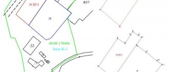
We found out that redistribution of land plots requires a number of documents. Who formalizes the redistribution of land? The procedure for the redistribution of land plots involves the participation of not only land owners, including municipal and state bodies, but other structures and individuals. Thus, as a result of redistribution, a boundary plan is prepared, the right to sign which belongs only to the registered cadastral engineer; in addition, the cadastral engineer provides advice and assistance both at the stage of preparing documents (schemes, projects) and after concluding an agreement.
In order to arrange land surveying, you should select a cadastral company or cadastral engineer in your region from the catalog of cadastral organizations. Following the link you will find a free and convenient online service - a price calculator for cadastral services, with which you can choose a cadastral work contractor.
The survey disk, as well as a package of documents for registration of newly created redistributed land plots, is transferred to the local MFC for subsequent registration with the Rosreestr authorities.
When the newly created plots are registered in the cadastral register, then the old ones will cease to exist.
Thus, due to the redistribution of land plots, it is possible to increase or decrease their area. An increase in area (addition of a land plot) can be either at the expense of state (municipal) lands or at the expense of private property. As a rule, in this situation, monetary compensation is usually specified in the agreement.
Increasing the area of land - is it free or for money?
There is an opinion that increasing the land plot can be done completely free of charge, but this is not so. It is only possible to obtain the adjacent lands for free, that is, they do not need to be purchased from the state, and the very registration of the new formation in the form of an enlarged land plot after the addition is a procedure that requires monetary costs. Indeed, in order to document newly created possessions, it is necessary to prepare a boundary plan. To do this, we enter into an agreement with a cadastral engineer, naturally on a paid basis. The newly created site must be coordinated and a ready package of documents must be submitted for registration to the MFC. All this time and money, but as a result you will receive a legally registered plot with an increased area.
You can find out the cost of cadastral works using a free service on the website - an online cadastral work calculator.
You can also find a catalog of companies in your region that provide cadastre services on the website.