Rules for the formation of land plots in 2021
In accordance with the Land Code (Article 11.2), there are several ways for new land plots to arise. This is how the general rules for the formation of land plots sound in 2021:
- Selecting one, or vice versa, combining several areas
- Redistribution of land plots
- Section (one area is divided into several)
But we will focus on the formation of land plots through redistribution. Let us clarify the procedure and procedure for redistributing land in 2021. We will also find out where to apply and what documents should be collected.
Taking into account the actual relations
On August 20, 2021, the Judicial Collegium for Civil Cases of the Supreme Court of the Russian Federation adopted determination N 127-KG19-12, in which it interpreted the provisions of the Land Code of the Russian Federation regarding the determination of the procedure for using a land plot (clause 1 of Article 35 of the Land Code of the Russian Federation) .
In this ruling, the Supreme Court of the Russian Federation reflected a number of conclusions that are interesting from a legal point of view, which very soon may become the basis for the formation of a new layer of law enforcement practice in disputes between shared owners whose common real estate is located on a land plot provided for perpetual use.
Fable of the case
At the center of the dispute is a conflict between two groups of shared owners of a homeownership located in the Republic of Crimea and consisting of residential buildings and outbuildings. The first group is represented by the owner of a share in home ownership in the amount of 34/100 (plaintiff), inherited from her husband. The second group includes two owners who own a share in the amount of 66/100 (defendants), which they had previously acquired from the plaintiff’s husband under a purchase and sale agreement.
The land plot on which the house is located was provided to the predecessor of the current owners in 1958 by the city executive authority for perpetual use for the construction of an individual residential building.
From the text of the judicial act it is clear that the parties to the conflict cannot register ownership of the disputed land plot due to disagreements regarding its use. That is, the owners of the home ownership continue to remain subjects of the right of perpetual use, and the subject of the claim is the requirement to determine the procedure for using the land plot.
At the same time, the parties independently, without legal registration, determined the procedure for using the buildings that are part of the home ownership (the houses were actually distributed between the plaintiff and defendants without any additional work to allocate shares).
The plaintiff also claims that by the time the defendants acquired shares in the right to home ownership, the established procedure for using the disputed land plot already existed. According to the plaintiff, the defendants agreed with him when purchasing the share by signing a purchase and sale agreement. In addition, a boundary fence has been installed on the disputed area for more than 15 years.
During the construction and technical examination carried out within the framework of the case, it was established that:
• the area of the land plot according to the public register (485 sq. m) is less than the area of the land plot actually used by the parties (545 sq. m)
• each of the houses is located on a separate part of the land plot, equipped with an isolated entrance and has an independent system of electricity, water, gas supply, heating and drainage
• the expert proposed an option for determining the procedure for using a land plot, according to which part of the plot with an area of 246 square meters. m is provided for use by the plaintiff, the other part with an area of 299 sq. m. m - to the defendants.
The courts of first and appellate instances dismissed the claim.
The main argument of the Zheleznodorozhny District Court of the city of Simferopol was that the procedure for using the land plot, proposed by the expert, taking into account the actual area of the land plot (545 sq. m.), does not correspond to the owners’ shares in the right of common shared ownership of the home, which, in the court’s opinion, violates para. 2 p. 1 art. 35 of the Land Code of the Russian Federation.
The Supreme Court of the Republic of Crimea, in its appeal ruling, recognized the above-mentioned argument of the trial court as illegal, but left the decision unchanged as consistent with the law, indicating that determining the procedure for using a land plot is possible only after the court has determined the procedure for using the buildings located on such a plot or simultaneously with it, as well as after registration in the manner prescribed by law of the right to use the land plot, establishing its boundaries in accordance with the requirements of the legislation of the Russian Federation .
The Judicial Collegium for Civil Cases of the Supreme Court of the Russian Federation did not agree with the legal argumentation of the lower courts, canceled the judicial acts adopted by them and sent the case for re-examination to the court of first instance.
Conclusions of the Supreme Court of the Russian Federation and their practical significance.
- The current legislation does not establish the need for exact correspondence of the part of the land plot allocated for use to the size of the share in the right of common shared ownership of the building.
According to paragraph 2 of paragraph 1 of Article 35 of the Land Code of the Russian Federation, in the event of a transfer of ownership of a building or structure to several owners, the procedure for using the land plot is determined taking into account the shares in the ownership of the building, structure or the established procedure for using the land plot.
A literal reading of this provision reveals at least two aspects taken into account by the courts when determining the procedure for using the site: a) the size of the share in the ownership of the building; b) the established procedure for using the land plot. Moreover, the presence of the conjunction “or” between them implies that both mentioned criteria cannot be used simultaneously. In addition, the very wording of the norm (the phrase “taking into account”) makes it clear that the specified criteria are a kind of legislative guideline for the courts in making a fair decision, but does not at all mean that it is impossible to deviate from such a guideline if necessary. And there is precisely a need in the case under consideration. From the text of the decision of the Judicial Collegium it follows that the part of the disputed land plot, which is in actual use of the plaintiff, has significant shortcomings. Thus, access to the site is possible through a narrow passage with a total area of 42 square meters. m, one of the sides of which is a retaining wall to the slope with a height difference of about three meters, and under the path paved with concrete slabs on the street side there is a system for draining storm water from the above-located land plot. Thus, if the court allocated to the plaintiff for use a part of the disputed land plot corresponding to his share in the ownership of the house (34/100), this would lead to the fact that the part of the plot necessary for servicing the plaintiff’s buildings would be in the use of the defendants , which would not allow the plaintiff to fully exercise his rights to own and use the buildings.
To delve deeper into the logic of the Supreme Court of the Russian Federation, one should turn to the practice of resolving a similar issue using the example of the general provisions of the Civil Code of the Russian Federation on determining the procedure for owning and using property that is in common shared ownership.
There are often cases when the share of one of the co-owners in the right to a common building is so small that it is not possible to divide such a building in kind or to separate a share from it. However, this does not mean at all that the owner will be forcibly deprived of his share with subsequent payment of compensation to him (clause 3 of Article 252 of the Civil Code of the Russian Federation). In the case where the co-owners do not set as their goal the division of common real estate, but cannot come to an agreement on the issue of ownership and use of it, each of them has the right to apply to the court with a claim to determine the order of ownership of the common property (Clause 1 of Art. 247 of the Civil Code of the Russian Federation). From the explanations of the Plenum of the Supreme Court of the Russian Federation and the Supreme Arbitration Court of the Russian Federation, contained in paragraph 37 of Resolution No. 6/8 of 07/01/1996 “On some issues related to the application of part one of the Civil Code of the Russian Federation”, it follows that the owner also has such a right , the share of which cannot be identified, including due to its insignificant size. In resolving such a requirement, the court takes into account the actual procedure for using the property, which may not exactly correspond to the shares in the right of common ownership, the need of each of the co-owners for this property and the real possibility of joint use.
It seems obvious that this position can and should be applied by analogy to the legal relations of persons arising from the joint use of a land plot transferred to such persons for perpetual use.
In the ruling under consideration, the Supreme Court of the Russian Federation indicated that the most important issues to be investigated in such cases are the question of the need of each of the users of the land plot to use one or another part of it and the established procedure for using the plot. And also that the disproportion of the part of the plot transferred to the owner to his share in the right to home ownership can be eliminated by providing monetary compensation.
Since over 15 years the parties have developed a certain procedure for using the disputed land plot (and there is even a demarcation fence), the court of first instance, when re-examining the case, will probably be forced to take this circumstance into account, as well as the shortcomings of that part of the land plot used by the plaintiff .
Thus, the Supreme Court, in its ruling, confirmed that the courts have the opportunity to exercise a certain degree of flexibility when resolving disputes regarding the determination of the procedure for using land plots, which hypothetically will facilitate the courts making fair decisions on this category of disputes, taking into account all the features of a particular plot and the existing relations of shared owners buildings.
- The shared owners of a structure do not have the obligation to determine in court the order of ownership and use of it before filing a claim in court to determine the order of use of the land plot on which such a structure is located.
In fact, the circumstances are such that the plaintiff and defendants determined the procedure for using the home ownership independently; there is no dispute between the parties on this issue. At the same time, the appellate court in its ruling came to the conclusion that it was necessary to resolve this issue in court before making a decision on the present case or simultaneously with it.
The Judicial Collegium of the Supreme Court of the Russian Federation stated the absence of such a requirement in the law. The position on the illegality of imposing on individuals the obligation to seek judicial protection of their rights and legitimate interests in a situation where there is no dispute about the right seems logical and consistent with the principle of the inadmissibility of arbitrary interference by anyone in private affairs (Clause 1 of Article 1 of the Civil Code of the Russian Federation).
They do not contain current legal acts and provisions obliging shared owners of buildings to re-register the right to use a land plot (bring documents into compliance with the legislation of the Russian Federation), as well as to establish boundaries (land surveying) of such a land plot.
A significant issue, practically not touched upon by the determination of the Judicial Collegium of the Supreme Court of the Russian Federation dated August 20, 2019 N 127-KG19-12, remains the ratio of the area actually used by the owners and the area of the land plot according to the data of title and title documents. Apparently, the Zheleznodorozhny District Court of Simferopol will have to give a legal assessment of this circumstance and determine the degree of influence on the outcome of the conflict during a new consideration of the case.
When there is a need for redistribution of land plots
The need for redistribution of land arises for various reasons. Most often, the owner addresses this issue when a problem arises that can be conveniently solved by redistributing land plots. For example, a broken border line; wedging of adjacent areas; communications supply; inconvenient approach or entrance; a house that has already been built goes beyond the maximum permissible boundaries of the fence. After all, in essence, redistribution of the area of land plots is a procedure for combining them and then dividing them. That is, the redistribution was created for the convenience of owners in order to eliminate additional red tape with documents.
The owner of a land plot can, by redistributing land plots, add to the land plot at the expense of adjacent lands and increase its area.
The main two options for redistribution of land plots
- The owners of the plots are individuals or legal entities.
In this case, interested parties need to carry out a set of cadastral works and sign an agreement among themselves on the redistribution of land plots.
- The owners, on the one hand, are an individual/legal entity, and on the other, a municipal entity.
The most common, but also more complex procedure. Includes coordination of the design redistribution scheme with the architecture department of the municipality.
Design rules
Expert opinion
Stanislav Evseev
Lawyer. Experience 12 years. Specialization: civil, family, inheritance law.
When concluding an agreement, like any other contract, the parties must first study the rules of execution. Otherwise, the document may be declared invalid or challenged in court.
The subject of an agreement on the redistribution of shares in common shared ownership can be both a land plot and a residential building. The parties can draw up a general document about two pieces of property or an individual form for each subject of the transaction.
Basic Rules:
- Voluntariness. Each of the co-owners must be notified of the upcoming procedure and have no objections. We are talking exclusively about co-owners who are going to enter into an agreement.
- Notification of co-owners. If there are several co-owners, then you need to notify them.
- Written form. A plot of land and a private house are objects, transactions with which are formalized exclusively in writing and are subject to state registration.
- Notarization. A transaction with real estate shares, including the redistribution of shares, must be certified by a notary.
- No encumbrance. The law prohibits any transactions with shares that are encumbered or under arrest. Therefore, before completing a transaction, it is advisable to obtain data from the Unified State Register of Real Estate about the absence of encumbrances.
Important! If the transaction is carried out in relation to an allotment that is part of the SNT, then notarization is not required. First, it is necessary to hold a general meeting of owners and draw up minutes of the meeting. The result is certified by the signature of the chairman of the SNT.
The agreement can be of the following types:
- paid (additional payment is provided for increasing the share);
- gratuitous (the share increases in the order of donation).
Information about the nature of the agreement must be indicated in the text of the document. Otherwise, the agreement is considered invalid.
Example. Raisa and Fedor divorced. The minor son remained to live with his mother. The family owned a private house. The object was in shared ownership. 1/2 share belonged to Fedor, ¼ share belonged to Raisa and son. Fedor was unable to pay alimony. Therefore, he entered into an agreement on the redistribution of shares, in which he transferred ¼ share of the house to his son.
Features of the redistribution of land plots from January 1, 2021
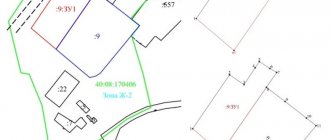
What are the features of the redistribution of land plots from January 1, 2021? According to the law, summer cottage plots cannot be redistributed. But this is only due to the fact that the concept of a summer cottage plot has been abolished since 2021 and replaced with a garden plot. Other innovations in legislation concern general changes in the cadastre system. They are associated with the entry into force of Law 150-FZ on September 16, 2019 (dated June 17, 2019), which provides for a new procedure for comprehensive cadastral work to coordinate the boundaries of SNT land plots, public areas and other areas owned by citizens. What happens as a result of the redistribution of land between owners? Everything is simple - a new section (sections) arises, with different coordinates and area. As for the cadastral number - whether it will be changed or not, this will be decided by the cadastral chamber.
Land use: legislative changes 2021
The rules by which you can own, use and dispose of your land have very often undergone changes in recent years.
To avoid all sorts of troubles, it is important for land owners to keep abreast of all the latest developments from legislators. I will present an overview of the most important innovations for landowners in recent times.
1. Owners are now responsible for the fertility of their lands.
On August 11 of this year, a Law came into force that established a new procedure for ensuring the fertility of agricultural land (Federal Law of July 31, 2021 No. 308-FZ).
Budgetary institutions subordinate to the Ministry of Agriculture of the Russian Federation will conduct scheduled inspections of agricultural lands to check their quality.
Based on the results of the research, the owner will be given a plan of mandatory measures that should be taken to restore soil fertility. He will also be provided with the necessary agrochemicals and equipment to carry out the work.
The law obliges landowners to provide access to their land for such an examination, as well as to comply with all instructions of government agencies for the reproduction of land fertility.
I would like to draw your attention to the fact that for non-compliance with the requirements for improving the quality of land, high fines are provided for owners: from 20 to 50 thousand rubles (Part 2 of Article 8.7 of the Code of Administrative Offenses of the Russian Federation).
It should be noted that the new rules do not apply to owners of land plots intended for gardening. But those who have their own plot of land from the category of agricultural land outside the SNT will now have more worries.
2. A federal highway can now be built on private land.
Recently, Rosreestr published on its official website a warning to all landowners: if land surveying has not been carried out on the land plots they own, then linear objects of federal, regional or local significance can now be laid on them (we are talking about roads, communication lines, pipelines, etc. .).
Since July 31 of this year, a new Law has been in force, which provides for a simplified procedure for issuing permits for the construction of engineering and transport infrastructure facilities: now they do not require registration of rights to land plots if they are in state or municipal ownership and are not burdened with the rights of third parties (Federal Law of July 31, 2020 No. 254-FZ).
However, such construction may also affect private land plots if their boundaries are not established (the coordinates of the characteristic points of the angles of rotation of the boundaries of land plots in the Unified State Register of Real Estate have not been determined), the developer may not know that, along with state and municipal lands, the construction will also cover his , private land.
He will receive permission, build an object - and only after that the owner can find out that, for example, a high-speed highway or a high-voltage power line now runs through his land.
Therefore, despite the fact that land surveying is now not mandatory for their owners, Rosreestr still recommends checking whether your land plot is registered with the state cadastral register (does it have a cadastral number) and whether its boundaries are displayed on the Public Cadastral Map (Official message on the Rosreestr website dated August 7, 2020).
3. New fines have been introduced for overgrown areas.
For several years now, owners of land plots of all categories have been required to promptly mow the grass on them under threat of a fine. The fact is that this is provided for by the current version of the Fire Safety Rules (approved by the RF PP dated April 25, 2012 No. 390).
And for violation of fire safety requirements, a fine of 3 to 4 thousand rubles is provided (Article 20.4 of the Code of Administrative Offenses of the Russian Federation). But now separate fines are also being introduced for a specific type of weed on the site, namely Sosnovsky’s hogweed.
In February of this year, the Federation Council called on the authorities to begin an active fight against the spread of hogweed. And the regions began to introduce fines for the owners of those land plots that were overgrown with this plant.
Instead of a conclusion:
In conclusion, I would like to say that Rosreestr has currently launched a procedure for deregistering land plots that were registered before March 1, 2008 and for which ownership has not yet been registered. If a land plot is removed from the cadastral register, then the local administration will be able to dispose of it at its own discretion.
In addition, the Government of the Russian Federation plans to involve unclaimed (not allocated) land shares of shareholders of former collective and state farms into circulation, giving municipalities the right to lease them to interested agricultural producers. It is planned to give “silent shareholders” or their heirs the opportunity to register their rights by January 1, 2025. Otherwise, from January 1, 2025, it is proposed to launch a mechanism for acquiring municipal ownership rights to such lands in the manner established for ownerless property.
In this regard, I recommend checking whether the rights to your land plot have been registered, whether it has been surveyed and its boundaries defined, in order to protect yourself from possible legal claims in the future!
Vitaly Kozyrev is a lawyer, cadastral engineer, forensic expert, member of the Public Council under the management of Rosreestr for the Pskov region, managing partner.
Procedure for redistribution
First, we collect a set of documents. To find out exactly what documents will be needed to redistribute land plots in your particular case, you should contact your local authorities. Article 39.29 of the Land Code states that in order to redistribute land plots, an agreement must be concluded between the owners, for the purpose of which an application is submitted.
Application for redistribution of land plots
The application is standard and easy to fill out. An approximate form can be found on the Internet, but it is better to ask your local authorities what application form is accepted in your municipality, since the application form is not generally accepted. You can also submit an application through government services or by mail.
The application must indicate:
- Full name, address, passport details (for individuals)
- Name and details (for legal entities)
- Cadastral numbers of plots
An integral part of the application will be a package of documents required for redistribution between land plots:
- an extract from the Unified State Register of Real Estate, or copies of documents on ownership or other legal ownership of land
- territory surveying project
- layout of the land plot (if there is no land surveying project)
- extract from the Unified State Register of Legal Entities or Unified State Register of Individual Entrepreneurs (for legal entities).
This is not an exhaustive list of documents. When redistributing land plots that are privately owned or state-owned, some other clarifying documents may be needed, it all depends on the individual case.
Agreement requirements
Before executing an agreement, the parties need to verify each other’s legal capacity. In addition, it is important to remember that it is prohibited to reduce the share owned by an incapacitated or minor owner. Even if their interests are represented by legal representatives.
The law does not specify the exact form for the agreement. However, it is subject to the general requirements for contracts.
The document must include the following items:
- Name;
- place of registration;
- date of conclusion;
- details of the parties, including gender, passport details and address;
- information about the land plot (cadastral number, address, total area, data of all owners);
- details of title documents;
- details of the extract from the Unified State Register;
- reasons for changes in the size of shares;
- compensation/free transfer of rights;
- new share options;
- a note indicating that there is no encumbrance on the rights of one of the share owners;
- rights and obligations of the parties;
- number of copies;
- signatures of co-owners.
Important! The absence in the agreement of data on the possibility of challenging the contract in court is not a prohibition on going to court. Either party has the right to protect its property interests in the event of a violation of rights, regardless of the terms of the contract.
Time limits for consideration of an application for redistribution of land plots
In accordance with Article 39.29 (clause 8) of the Land Code, the period for consideration of an application for redistribution of land plots is 30 working days . This period may be extended to 45 working days if additional documentation or materials are required to review the application. If the application is submitted with violations (there are not enough documents in the package, it is submitted to another authority), then it is returned within 10 days from the date of receipt. Having considered the application for concluding an agreement on land redistribution, the administration makes one of the following decisions:
- Approve the layout plan, or, based on the approved land surveying project, give a positive response to the signing of an agreement on the redistribution of land plots;
- Refuse to conclude an agreement on the redistribution of land plots, indicating legitimate reasons.
If the application is considered and the answer is positive, then the next step will be a Land Redistribution Agreement . An agreement on the redistribution of land plots must be concluded in writing - this is a voluntary desire of the parties with a detailed description of the methods and motives for the redistribution. An agreement is drawn up between interested plot owners. Owners can be private individuals, the state or a municipality.
We will talk about the opportunity provided by the Land Reform of 2015 (Federal Law No. 171 dated June 23, 2014), in a simplified form, to add individual housing construction and private plots to existing private plots for dacha farming or dacha construction, for gardening or truck farming.
Let’s talk about the registration of those seemingly “nobody’s” and seemingly unoccupied small territories, which, in principle, are already in fact used and were previously angrily assessed by administrative bodies as “arbitrarily seized”, for which they had to bear responsibility for their release from “seizure” should be formalized through the courts with the payment of significant fines, or those adjacent to the site, it is not clear to whom or what they belong to, which so far they have only “laid an eye on” and which are very necessary for normal suburban development.
Let us say right away that there cannot be “nobody’s plots”. Any site, even if by outward appearances it is not in use and there is nothing on it, is owned either by citizens, or companies, enterprises, or gardening, or is the property of the municipality or the state.
It is unlikely that anyone will be able to cut off a “piece” of land that is part of someone else’s private plot (someone else’s property), but the law that has come into effect allows the issue to be resolved with the municipality and the state, unless this piece to be cut does not belong to the so-called reserved lands and funds for further or existing serious tasks.
You can check the state of the situation in such cases on a public cadastral map. The advice presented here will help you to obtain the necessary information using the available information - the cadastral number or the address of the site.
Why is it possible to cut off vacant municipal and state lands?
Land reform influenced the parallel revision of the Land Code of the Russian Federation (LLC RF), to which an addition was made - a whole new chapter “Redistribution of lands and (or) land plots” (Chapter 5.4), which fully regulates the procedure for solving the problem of “additions”. You can get acquainted with it here.
All citizens of the Russian Federation can now take advantage of the “cutting” of land - those, we repeat once again, who are the owners of plots provided for individual housing construction, private plots, dacha farming or dacha construction, gardening or truck farming.
“An increase”, that is, an increase in the area of a land plot above that recorded in the title documents, in accordance with what is actually used, is now called “redistribution of land plots”.
The need for cutting may arise, for example, when the site has a broken shape, which creates great inconvenience when arranging it, when clarifying its boundaries, or in situations of “overlapping” adjacent areas, which often occur both in gardening and during a very long period of use in villages.
The unauthorized use of land that is not one’s own remains a “sword of Damocles” for any owner, who sooner or later will have to either vacate the illegally occupied territory, demolish the buildings on it, having received the appropriate instructions, or deal with the problem in a timely manner.
Let’s now look at how to solve the issue of “land cutting”.
When is it possible to trim and about restrictions on the areas to be trimmed?
It is possible to begin solving the problem of cutting into a plot only if the ownership rights to the plot are formalized and it is demarcated, that is, it has specific boundaries and area, and is registered in the cadastral register.
In addition, the land plot formed after cutting should not go beyond the boundaries of the settlement - settlement, dacha cooperative, municipality (Land Code of the Russian Federation, Article 11.9, clause 3) and should not fall into public territory; should not be outside the boundaries of the development - behind the “red lines” delimiting the zones of various linear objects (roads, communications, etc.)
It is not always possible to add as much area to an existing plot of land as you like. Since this is a fairly significant point in the planned trimming problem, let us explain it in a little more detail.
The issue can be resolved without problems if the increase in area does not exceed 10% of that entered into the state cadastre, but it is still impossible to legalize the cut-off lands of the forest fund, as well as coastal strips.
There are standards for maximum plot sizes established by the PZZ in each municipality. It is they who determine the possible minimum and maximum areas of land plots provided for individual housing construction, private plots, dacha farming or dacha construction, gardening or truck farming, and, accordingly, for cut-off plots.
In terms of area, the area obtained in total with the addition should not exceed the established limits (Clause 1, Article 39.28 of the Land Code of the Russian Federation).
If the maximum area is exceeded, you will have to decide on the formation of a new plot or plots in the sizes allowed by regulations and buy them, although not at a fabulous cost, but at the full cadastral value established in a particular settlement.
The size of the maximum areas for the types of permitted uses of land can be found in the Land Management and Development Rules (PLR) adopted in each settlement on the official website of the settlement administration or by directly contacting the land use committee or department of the district administration or settlement administration.
Before solving the problem of adding area to a plot using the PZZ maps, you need to make sure that the “addition” belongs to the same territorial functional zone (individual housing construction, private household plots, dacha farming, etc.) as the plot itself. On the maps-schemes of the PZZ, the boundaries of the territorial zones are indicated in different colors with an indication of the urban planning regulations directly in these maps (clause 7 of Article 1 of the Urban Planning Code of the Russian Federation).
Otherwise, that is, when the “extension” falls into another territorial functional zone, for example, into a public-business zone, production or another, instead of the individual housing construction zone or, for example, “for dacha farming,” the solution to the problem becomes impossible, unless, of course, you start changing the general plan of the settlement and its PZZ, making the necessary changes to them, which will be practically impossible for any private owner.
In cases where the PZZ in the settlement has not yet been adopted, the maximum size of plots for individual housing construction, private plots, dacha farming or dacha construction, gardening or truck farming is approved by separate decisions of local deputies or regional laws “On the maximum size of land plots”.
The procedure for registering an extension to a site - concluding a Redistribution Agreement
Redistribution (addition to a land plot) is formalized by concluding an Agreement on the redistribution of land plots, which is concluded between the owner of the redistributed territory (municipal administration, regional or regional government, or a representative of the Russian Federation, if the addition relates to federal property) and the owner of the land plot who intends to increase (cut) additional area (Article 39.29 of the Land Code of the Russian Federation).
To prepare for the conclusion of such an Agreement, the owner of a land plot who plans to expand it submits to the district administration or the regional government an application for redistribution of the land plot, attaching a number of documents and indicating the necessary information about the plot and about himself.
The application form is approved in each municipality and is provided for completion directly upon application.
Main documents attached to the application
- copies of the certificate of ownership or title document for the land plot, if the ownership of the land plot is not registered in the Unified State Register;
- land surveying project for the territory on which the site is located;
- if there is no project for surveying the territory within the boundaries of which it is planned to redistribute land plots, a diagram of the location of the future land plot on the cadastral plan of the territory must be attached.
Note
The owner of the plot will have to prepare a diagram of the location of the territory of the future land plot on the cadastral plan, displaying its boundaries and indicating the part to be cut off - this is what the requirement of Art. 11.10, clause 8 of the Land Code of the Russian Federation.
It is more convenient to order it from a local geodetic or land management company or from cadastral engineers working directly in a particular area. If the owner of the plot is not a surveyor or cadastral engineer, it is unlikely that he will be able to cope with the preparation of the diagram himself, because it is done on the basis of information obtained from the results of a geodetic survey (Article 11.3 of the Land Code of the Russian Federation).
When submitting applications, representatives or trustees provide documents confirming their right and authority to perform actions;
When submitting applications from a foreign legal entity that is the owner of a land plot - documents on state registration of the legal entity in accordance with the legislation of a foreign state with a certified translation into Russian.
An application with documents can be submitted in various convenient ways:
- using interdepartmental information interaction;
- in person or by post on paper;
- in the form of electronic documents using the Internet, having familiarized themselves with the requirements for their format, approved by the federal executive body authorized by the Government of the Russian Federation.
Time limits for consideration of an application for redistribution of land plots
The period established by law for consideration of an application for redistribution of land plots is 30 days (Clause 8, Article 39.27, Chapter 5.4 of Federal Law No. 171 of June 23, 2014).
During this time, the administration performs the following actions:
considers the application and makes a positive decision on approval of the layout of the land plot; sends its decision on approval of the layout with its attachment to the applicant; sends its consent to the conclusion of an agreement on the redistribution of land plots in accordance with the approved land surveying project.
Reasons for refusal to conclude a redistribution agreement
Grounds for refusal to conclude an agreement on the redistribution of land plots may be at least one of the following reasons:
- inconsistency of the submitted application with cases of redistribution of land plots, which are provided for by law (Clause 1.Article 39.27 of Chapter 5.4 of Federal Law No. 171 of June 23, 2014);
- lack of consent of third parties, stated in writing, if the cut-off area is burdened with their rights, for example, a mortgage from a bank that requires approval from it;
- on the cut-off site there is a building or structure, an object of unfinished construction, owned by the municipality or the state, or owned by citizens or legal entities;
- the cut-off area refers to municipal or state lands withdrawn from circulation or limited in circulation;
- the cut-off area refers to lands reserved for state or municipal needs;
- for the cut-off area, a decision has been prepared to hold an auction with the publication of a notice of the holding and preliminary approval for its provision has been completed and the validity period of the decision has not yet expired;
- another application for preliminary approval for its provision has already been submitted for the cut-off area, but decisions have not yet been made either in agreeing and approving the layout scheme, or in refusing (as many like to say, “whoever stood up first, got his slippers”);
- the area of the cut plot will increase the area of the one formed by its merger with the main one, exceeding by more than 10% the established sizes of the maximum areas of land plots;
- the cut section cannot be considered as an “additive” and must be formed as an independent one;
- the boundaries of the main area to which the extension is planned require clarification - that is, if the main area is not demarcated;
- inconsistency with the layout of the land plot:
- according to its form or training requirements;
- by full or partial coincidence of the location of the future land plot with the location of the main land plot,
- for violations committed during the development of the scheme,
- for non-compliance with the existing territory planning project, land management documentation, regulations on a specially protected natural area;
- for non-compliance with the boundaries of the territory for which the territory surveying project has been approved.
The lack of information on the added plot in the state real estate cadastre (GKN) about the location of the boundaries of the land plot (clause 12 of Article 39.29 of the Land Code of the Russian Federation) will not be a reason for refusal to add municipal or state land.
In this case, the applicant will need to carry out cadastral work and put an “addition” on the state cadastral register, and only after all, attach it to his plot.
Refusal to conclude an agreement on the basis of clause 9 of Article 39.27 of Chapter 5.4 of Federal Law No. 171 of June 23, 2014) must be motivated, with a detailed statement of the reasons.
A positive decision on approval of the land redistribution scheme has been received - what next?
If the decision to approve the layout of the land plot has been received from the administration, you will then need to put the plot with the cut-off on the cadastral register at your own expense, having previously completed boundary work (Clause 14, Article 39.29).
The received cadastral passport must be presented to the administration and the draft Agreement on the redistribution of land plots prepared by the administration must be signed with it. The signing of the agreement and payment for the “cut-in” must take place no later than 30 days from the date of receipt of the project, which will indicate, in particular, the cost of the cut-off area.
About the cost of “additions”
The cost of the “addition” purchased from the municipality depends on the cadastral value of the land plot, amounting to 15% of its value, if the plot belongs to federal lands and the added area does not exceed the established maximum values, and if the maximum permitted area is exceeded by more than 10%, the payment will be be calculated at the full cadastral value (Resolution of the Government of the Russian Federation No. 1308 of December 3, 2014).
For plots belonging to regional lands or demarcated lands of state property, the cost is set by the municipality, depends on the location, but, as a rule, practically does not differ from the cost of federal land, that is, 15% of the cadastral value, subject to compliance with area limits.
Knowing the area of the plot, simple arithmetic calculations can be used to estimate upcoming expenses.
The cadastral value is indicated in the cadastral passport; you can familiarize yourself with it on the public cadastral map of Rosreestr or check with the local administration.
There are no deferments or installment plans for payments for “additions” to plots. But we can confidently say that the cost of additions is significantly lower than market values for the purchase of plots of similar areas.
Who formalizes the redistribution of land?
We found out that redistribution of land plots requires a number of documents. Who formalizes the redistribution of land? The procedure for the redistribution of land plots involves the participation of not only land owners, including municipal and state bodies, but other structures and individuals. Thus, as a result of redistribution, a boundary plan is prepared, the right to sign which belongs only to the registered cadastral engineer; in addition, the cadastral engineer provides advice and assistance both at the stage of preparing documents (schemes, projects) and after concluding an agreement.
In order to arrange land surveying, you should select a cadastral company or cadastral engineer in your region from the catalog of cadastral organizations. Following the link you will find a free and convenient online service - a price calculator for cadastral services, with which you can choose a cadastral work contractor.
The survey disk, as well as a package of documents for registration of newly created redistributed land plots, is transferred to the local MFC for subsequent registration with the Rosreestr authorities.
When the newly created plots are registered in the cadastral register, then the old ones will cease to exist.
Thus, due to the redistribution of land plots, it is possible to increase or decrease their area. An increase in area (addition of a land plot) can be either at the expense of state (municipal) lands or at the expense of private property. As a rule, in this situation, monetary compensation is usually specified in the agreement.