Rules for the formation of land plots in 2021
In accordance with the Land Code (Article 11.2), there are several ways for new land plots to arise. This is how the general rules for the formation of land plots sound in 2021:
- Selecting one, or vice versa, combining several areas
- Redistribution of land plots
- Section (one area is divided into several)
But we will focus on the formation of land plots through redistribution. Let us clarify the procedure and procedure for redistributing land in 2021. We will also find out where to apply and what documents should be collected.
The formation of a land plot is a unique form of disposal of one’s property, primarily by the owner of the land plot, which is provided for by land legislation. The specificity of the legal regime of a land plot as real estate and an object of nature led to the consolidation in legislation of this concept and special ways of disposing of land property. Such methods are division, allocation of land, consolidation, redistribution of land. As a result, a new land plot (land plots) is created, and the previous plot (plots) ceases to exist or is changed.
According to Art. 11.4 of the Land Code of the Russian Federation, the division of a land plot is the formation of several plots from one. In this case, the original site ceases to exist. The following conditions are established for the division and allocation of land plots:
preservation of land category;
compliance with the minimum plot size. Yes, Art. 33 of the Land Code of the Russian Federation determines the procedure for establishing the maximum and minimum sizes for the provision of plots. The specific sizes of plots are determined by local governments, and are also established in accordance with the approved norms for land allocation for specific types of activities or in accordance with the rules of land use and development, land management, urban planning and design documentation;
compliance with urban planning regulations. For example, if there is one piece of real estate on a plot, the division of which in kind is impossible without the formation of parts of the object firmly connected to the plot, then such a plot is indivisible. In such cases, rules are applied to regulate legal relations regarding an indivisible land plot between the owners of premises in a building (apartment building, industrial and administrative buildings, etc.);
the absence of a legal ban on the division of land. So, for example, in accordance with Art. 9 of the Federal Law of June 11, 2003 N 74-FZ “On Peasant (Farm) Farming”, when one of the members of the holding leaves, the land plot is not subject to division.
In all cases of formation of land plots, their intended purpose and permitted use are recognized as the intended purpose and permitted use of the land plots from which they were formed by division, merger, redistribution or allotment.
The formation of land plots is permitted with the written consent of land users, landowners, tenants, mortgagees of land plots, from which land plots are formed during division, merger, redistribution or allocation.
No consent is required for the formation of land plots from land plots that are in state or municipal ownership and provided to state or municipal unitary enterprises, state or municipal institutions. The formation of land plots from land plots that are privately owned and owned by several owners is carried out by agreement between them on the formation of a land plot, with the exception of the allocation of land plots on account of the share in the common ownership of land plots from agricultural lands in the manner prescribed by the Federal Law of July 24, 2002 N 101-FZ “On the turnover of agricultural land”.
The formation of land plots can be carried out on the basis of a court decision without fail, regardless of the consent of the owners, land users, landowners, tenants, mortgagees of land plots, from which land plots are formed during division, merger, redistribution or allocation. The formation of land plots from land plots located within the boundaries of a built-up area, in respect of which, in accordance with the Town Planning Code of the Russian Federation, a decision has been made on its development and an agreement on the development of the built-up area has been concluded, is carried out by the person with whom such an agreement has been concluded, in accordance with the documentation for planning of the territory, approved in the manner established by the legislation on urban planning activities. Disputes regarding the formation of land plots are considered in court.
Features of the state registration of rights to land plots formed during the division, merger, redistribution of land plots or allocation from land plots are provided for in Article 22.2 of the Federal Law of July 21, 1997 N 122-FZ “On state registration of rights to real estate and transactions with it " In particular, paragraph 1 of this article establishes the grounds for state registration of the above land plots:
1) a decision on the division or consolidation of state or municipally owned land plots;
2) an agreement on division, on consolidation, on redistribution of land plots or on allocation from land plots;
3) another document on the basis of which, in accordance with this Federal Law and other federal laws, the formation of land plots is carried out.
State registration of rights to land plots formed during the division or merger of land plots owned by one person is carried out on the basis of an application from such a person. State registration of rights to land plots formed during the division, consolidation or redistribution of land plots in state or municipal ownership is carried out on the basis of an application from an executive body of state power, a local government body or a person acting on their behalf, or on the basis of an application from persons to whom such land plots are provided in accordance with the Land Code of the Russian Federation.
Mandatory attachments to documents submitted in accordance with paragraphs 1 and this article are:
1) a title document for the land plot from which the land plots are formed (hereinafter referred to as the original land plot). Submission of a title document is not required if the right to the corresponding land plot was previously registered in the manner established by this Federal Law;
2) consent in writing of persons to the formation of land plots if the need for such consent is provided for by the Land Code of the Russian Federation.
State registration of rights is carried out simultaneously in relation to all land plots formed during the division, redistribution of land plots or allocation from land plots.
If the land plot from which land plots are formed during division, merger, redistribution or allotment has not been registered in the prescribed manner, this is not an obstacle to the state registration of rights to the newly formed land plots.
It should be noted that in accordance with Art. 13 of the Law of the Krasnodar Territory dated November 5, 2002 No. 532-KZ “On the fundamentals of regulation of land relations in the Krasnodar Territory” (as amended by the Law of the Krasnodar Territory dated July 19, 2011 No. 2317-KZ), unless otherwise provided by the legislation of the Russian Federation, when committing transactions with land plots, as well as in other cases in which their division occurs (except for the case of merger with a neighboring land plot), the formation of land plots whose area is less than:
400 square meters, with a plot width of at least 8 meters - for land plots provided for gardening;
600 square meters, with a plot width of at least 12 meters - for land plots provided for individual housing construction or personal farming.
This provision of the law came into force in our region from the date of official publication in the official periodical that publishes regulatory legal acts of the Krasnodar region - the newspaper “Kuban News” No. 127 dated 08/02/2011.
Chief specialist expert, state registrar Plotnikova E.Yu.
When there is a need for redistribution of land plots
The need for redistribution of land arises for various reasons. Most often, the owner addresses this issue when a problem arises that can be conveniently solved by redistributing land plots. For example, a broken border line; wedging of adjacent areas; communications supply; inconvenient approach or entrance; a house that has already been built goes beyond the maximum permissible boundaries of the fence. After all, in essence, redistribution of the area of land plots is a procedure for combining them and then dividing them. That is, the redistribution was created for the convenience of owners in order to eliminate additional red tape with documents.
The owner of a land plot can, by redistributing land plots, add to the land plot at the expense of adjacent lands and increase its area.
REAL ESTATE CADASTRE AND MONITORING OF NATURAL RESOURCES
UDC 347.214.2Klyueva E.N., student
Scientific supervisor: Slipets A.A., Ph.D.
Kaluga branch of the Russian State Agrarian University - Moscow Agricultural Academy named after K.A. Timiryazev, Russia
Describes the preparation of a boundary plan for the formation of a land plot through division while maintaining the original land plot within the changed boundaries.
Since there is currently a constant change in legislation in the field of land management and cadastres, specialists in this area must clearly understand the structure of preparing a boundary plan depending on the type of cadastral work.
The formation of land plots can occur through division, consolidation, redistribution of land plots or allocation from land plots, as well as from lands in state or municipal ownership [1, 2].
There are two types of division of land [1] (hereinafter referred to as ZU):
1) Division of a land plot, as a result of which several land plots are formed. In this case, the original land plot from which new plots are formed ceases to exist.
2) Division of a land plot, as a result of which several new land plots may be formed, but the original land plot does not cease to exist, but remains within the changed boundaries.
During the division procedure, it is important to consider the following conditions:
1) The land plot to be divided must be on the state cadastral register (hereinafter referred to as the GCU).
2) Absence of a ban on the implementation of the division. Plots for farming are not subject to division.
3) The land plots being formed must have independent entrances or approaches.
4) The formed land plots must be within the boundaries of one territorial zone.
5) Each resulting land plot must comply with the size limits established by local governments [4].
Let us analyze the preparation of the boundary plan in connection with the formation of land plots by dividing the land plot while maintaining the original land plot with cadastral number 40:08:170406:9 within the changed boundaries.
In order to carry out the division of a land plot while preserving the original one, the owner of the land plot turns to the cadastral engineer with a request to prepare a boundary plan. Since the division of a land plot while preserving the original one was carried out on state or municipally owned lands, the local government body acts as the owner of such a plot.
The boundary plan for the division, preserving the original one, was formed on the basis of a resolution approving the layout of the land plot on the cadastral plan of the territory (hereinafter referred to as the CPT) and the approved layout of the land plot on the CPT, which were prepared in advance by the cadastral engineer and approved by the head of the administration of the municipality.
The land plot with cadastral number 40:08:170406:9 is located on the territory of the Iznoskovsky district, village. Wear and tear. The category of land for this site is land of settlements with the type of permitted use “for production needs.”
To prepare the boundary plan, the cadastral engineer needed the following documents: an extract from the Unified State Register of Real Estate, resolutions on approval of the layout of the land plot on the KPT and the layout itself, cadastral plan of the territory, land use and development rules of the municipality and the decision on the appointment of the head of the administration of the municipality. Based on them, the cadastral engineer fills in and generates the text and graphic parts of the boundary plan.
The text part of the boundary plan contains sections strictly established by Order of the Ministry of Economic Development of Russia dated December 8, 2015 N 921 [3].
The graphic part of the boundary plan is displayed by a diagram of the location of land plots (Fig. 1a) and drawings of land plots and their parts (Fig. 1b).
Fig. 1 - Graphic part of the boundary plan
Note that the boundary plan must be accompanied by a diagram of the location of the charger at the KPT. In this case, the type of permitted use of the formed land plot must strictly correspond to the type of permitted use of the original land plot.
The boundary plan for the section, preserving the original land plot, is prepared in electronic form in the form of an XML document, as well as on paper for the owner of the land plot in one copy.
To enter information into the Unified State Register of Real Estate, the owner of the land plot provides a boundary plan on electronic media (CD disk) to Rosreestr. After registering the rights with the Civil Code of Ukraine, the owner of the land plots receives extracts from the Unified State Register of Real Estate, which contain new and changed information about the land plots. The resulting land plot is assigned a new cadastral number, and the original plot retains its cadastral number within the changed boundaries.
Bibliography
- “Land Code of the Russian Federation” dated October 25, 2001 N 136-FZ (as amended on October 15, 2020) - [Electronic resource] - access mode: https://www.consultant.ru/document/cons_doc_LAW_33773/
- Federal Law of July 13, 2015 N 218-FZ (as amended on July 13, 2020) “On State Registration of Real Estate” [Electronic resource]/ access mode: https://www.consultant.ru/document/cons_doc_LAW_182661/
- Order of the Ministry of Economic Development of Russia dated December 8, 2015 N 921 (as amended on December 14, 2018) “On approval of the form and composition of land survey plan information, requirements for its preparation” (Registered with the Ministry of Justice of Russia on January 20, 2016 N 40651) [Electronic resource]/ access mode : https://docs.cntd.ru/document/420325639
- Musina E.F., Tairova G.K., Ishbulatov M.G. // Cadastral work on the formation of land by dividing a land plot. Collection of articles based on materials from the international scientific and technical Internet conference. – 2021 – [Electronic resource]/access mode: https://kadastr.org/conf/2019/pub/kadastr/kadastrovye-raboty-po-obrazovaniyu-zemel-putem-raz.htm
The main two options for redistribution of land plots
- The owners of the plots are individuals or legal entities.
In this case, interested parties need to carry out a set of cadastral works and sign an agreement among themselves on the redistribution of land plots.
- The owners, on the one hand, are an individual/legal entity, and on the other, a municipal entity.
The most common, but also more complex procedure. Includes coordination of the design redistribution scheme with the architecture department of the municipality.
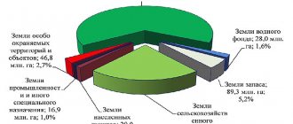
Land fund
The land fund is the entire territory of the state, including water expanses within the fixed state borders. Depending on their intended purpose, Russian lands are divided into the following categories:
- Agricultural grounds.
- Land for settlements.
- Industrial, transport, energy, security and defense areas plus land supporting space activities.
- Forest and water resources.
- Reserve lands.
- Objects and territories with a special protection regime.
Features of the redistribution of land plots from January 1, 2021
What are the features of the redistribution of land plots from January 1, 2021? According to the law, summer cottage plots cannot be redistributed. But this is only due to the fact that the concept of a summer cottage plot has been abolished since 2021 and replaced with a garden plot. Other innovations in legislation concern general changes in the cadastre system. They are associated with the entry into force of Law 150-FZ on September 16, 2019 (dated June 17, 2019), which provides for a new procedure for comprehensive cadastral work to coordinate the boundaries of SNT land plots, public areas and other areas owned by citizens. What happens as a result of the redistribution of land between owners? Everything is simple - a new section (sections) arises, with different coordinates and area. As for the cadastral number - whether it will be changed or not, this will be decided by the cadastral chamber.
The art of cutting and living
This happens when receiving an inheritance, during divorces and in other similar cases.
Few people know that in such operations, the size of the future sections that will be obtained after division is extremely important.
The fact is that, according to the law, it is possible to give a person his share only if all the plots formed after the division correspond to the minimum permitted size for the intended use of the land.
That is, if initially the plot was provided for gardening, then it must be divided so that each part can continue to be engaged in this gardening.
Similar clarifications were given when the Judicial Collegium for Civil Cases of the RF Armed Forces reviewed the results of a trial of a land dispute in the Volgograd region. There, a citizen came to court and asked to be allocated part of a house and a plot of land, which were owned by several owners on the basis of common shared ownership.
In court, the plaintiff explained that he owned a two-thirds share of the house and land. According to the BTI passport, the total area of the house is 70.1 square meters. m., and the plot is 506 sq.m. One third of the share was owned by the woman, and after her death - by the heir.
If the plot is intended for gardening, then it must be divided so as not to interfere with gardening
This heir did not agree with the neighbor’s demand and brought a counterclaim to court - to divide the house and land according to the option that he proposes.
The local court sided with the plaintiff and divided the house and land. The plaintiff got 337.3 sq. m, and the defendant - 167.7 sq. m. m.
The appeal agreed with this decision.
The local Volgograd court, when making this decision, followed the simplest path - it divided the house and land according to the historical use order there - without deviating from the size of the shares in the parties' ownership of the house and land.
The Supreme Court did not agree with this decision and explained why.
The Land Code (Article 1) states that plots owned by citizens are formed in different ways. Plots are redistributed from existing plots, allocated from existing plots, plots from state or municipal property are given away or sold. According to the same Land Code, the allocation of a share from a plot of land is the same as the allocation of a plot. And the one from which a part was “cut off” will continue to be considered a site, but within new boundaries. The person who had the share, after the allocation, becomes the real owner of the received plot, and the remaining owners of the shares remain the owners of the parts in a single plot.
Another important point is that the Land Code states that no matter how parts of the whole plot are changed, cut or separated, all its shares must correspond to the original intended purpose and permitted use. According to the law, plots, depending on their intended purpose and permitted use, have maximum minimum and maximum sizes.
In 1996, a general plenum of the Supreme and Supreme Arbitration Courts was held (N6/8 of July 1, 1996). At this plenum there was talk about the Civil Code. It contains Article 252, which states that the court has every right to refuse the claim of a participant in shared ownership who has asked to allocate a share in kind. Refusal is possible if the allocation of a share would entail “disproportionate damage to property in common ownership.” That is, if after allocating a piece of land, the remaining plot cannot be used for its intended purpose. In this case, the concept of “damage” must be understood as a serious deterioration in the technical condition, the inability to use the thing for its intended purpose, inconvenience in use, a decrease in the cultural or artistic value of the thing. In the latter case, we are no longer talking about land, but about collections of paintings, objects, or libraries.
These clarifications, the Supreme Court emphasized, comply with the Law “On the State Real Estate Cadastre”. According to it, the cadastral authority decides to refuse to register a plot if the new plot or the remaining old one does not comply with the minimum and maximum dimensions prescribed by law.
From all that has been said, the Judicial Collegium for Civil Cases of the Supreme Court concludes that the allocation of a share in kind to one of the owners of a land plot is possible only if this plot and the plots remaining after division have an area not less than the minimum permitted and corresponding to the intended purpose.
The Land Code states that maximum and minimum sizes are established by urban planning regulations. The Town Planning Code states that land use rules and sizes are written by local authorities.
In our situation, there is a resolution of the Volga City Duma of the Volgograd region. According to it, the maximum minimum plot is 0.02 hectares, and the maximum maximum is 0.2 hectares. Therefore, in our dispute, the newly formed plot, which the court allocated for the ownership of the defendant - 168.7 square meters - does not meet the requirements of the law. The Supreme Court of the Russian Federation ordered the land dispute to be reconsidered.
Procedure for redistribution
First, we collect a set of documents. To find out exactly what documents will be needed to redistribute land plots in your particular case, you should contact your local authorities. Article 39.29 of the Land Code states that in order to redistribute land plots, an agreement must be concluded between the owners, for the purpose of which an application is submitted.
Application for redistribution of land plots
The application is standard and easy to fill out. An approximate form can be found on the Internet, but it is better to ask your local authorities what application form is accepted in your municipality, since the application form is not generally accepted. You can also submit an application through government services or by mail.
The application must indicate:
- Full name, address, passport details (for individuals)
- Name and details (for legal entities)
- Cadastral numbers of plots
An integral part of the application will be a package of documents required for redistribution between land plots:
- an extract from the Unified State Register of Real Estate, or copies of documents on ownership or other legal ownership of land
- territory surveying project
- layout of the land plot (if there is no land surveying project)
- extract from the Unified State Register of Legal Entities or Unified State Register of Individual Entrepreneurs (for legal entities).
This is not an exhaustive list of documents. When redistributing land plots that are privately owned or state-owned, some other clarifying documents may be needed, it all depends on the individual case.
Commentary on Article 11.3 of the Land Code of the Russian Federation
From the structure of Chapter I.1 of the Land Code of the Russian Federation, it is clear that the legislator considered it necessary to highlight the issues of formation of land plots in public ownership in a separate article, thereby determining that the process of formation of such land plots is characterized by some features in comparison with the general rules on the formation of land plots. plots.
These features are contained in a certain list of documents in accordance with which such land plots can be formed. These include a territory surveying project approved in accordance with the Civil Code of the Russian Federation, project documentation on the location, boundaries, area and other quantitative and qualitative characteristics of forest areas, as well as a diagram of the location of the land plot on the cadastral plan of the territory. At the same time, the formation of land plots in accordance with the layout of the land plot on the cadastral plan of the territory is allowed only in the absence of an approved land surveying project.
Thus, as a matter of priority, the formation of land plots in state or municipal ownership is carried out on the basis of a territory surveying project. This approach allows for the most rational organization of the process of formation of land plots, including for the purpose of further provision to citizens and legal entities, since it fully complies with the principles of sustainable development of territories and the implementation of construction on the basis of territory planning documentation, on which the legislation on urban planning is based (Clause 4, Article 2 of the Civil Code of the Russian Federation). According to Art. 43 of the Civil Code of the Russian Federation, the text part of the territory surveying project includes: a list and information about the area of land plots to be formed, including possible methods of their formation; a list and information on the area of land plots being formed that will be classified as public areas or public property, including in respect of which reservation and (or) withdrawal for state or municipal needs is expected; type of permitted use of the resulting land plots in accordance with the territory planning project in cases provided for by the Civil Code of the Russian Federation. The territory survey drawings display: the boundaries of the planned (if the preparation of the territory survey project is carried out as part of the territory planning project) and existing elements of the planning structure; red lines approved as part of the territory planning project, or red lines approved or changed by the territory surveying project; indentation lines from the red lines in order to determine the locations of permissible placement of buildings, structures, and structures; the boundaries of the land plots being formed and (or) being changed, the conventional numbers of the land plots being formed, including in relation to which they are expected to be reserved and (or) withdrawn for state or municipal needs; boundaries of public easement zones.
According to Part 5 of Art. 43 of the Civil Code of the Russian Federation, the territory surveying project includes drawings of the territory surveying, which display the red lines approved as part of the territory planning project; indentation lines from the red lines in order to determine the location of the permissible placement of buildings, structures, structures; the boundaries of built-up land plots, including the boundaries of land plots on which linear objects are located; boundaries of land plots being formed, planned to be provided to individuals and legal entities for construction; boundaries of land plots intended for the placement of capital construction projects of federal, regional or local significance; boundaries of territories of cultural heritage sites; boundaries of zones with special conditions for the use of territories; boundaries of public easement areas.
According to Art. 46 of the Civil Code of the Russian Federation, the preparation and approval of documentation for the planning of the territory, developed on the basis of a decision of the local government body of a settlement or urban district, is carried out taking into account the results of public hearings. In this regard, the population can express their own opinion regarding the approved documentation on the planning of the territory in terms of the projected boundaries of future land plots, formed for further provision to citizens and legal entities. This is fully consistent with the legal nature of such an institution as public hearings. Preparation of the territory planning project and the territory surveying project is carried out in accordance with the coordinate system used for maintaining the state real estate cadastre (Part 6 of Article 41 of the Civil Code of the Russian Federation). ——————————— As noted in the Determination of the Constitutional Court of the Russian Federation of July 15, 2010 N 931-О-О (Bulletin of the Constitutional Court of the Russian Federation. 2011. N 2), being a public law institution designed to ensure open, independent and free discussion of socially significant problems (issues) that are of significant importance for citizens living in the territory of the relevant public entity, public hearings, within the meaning of Article 3 of the Constitution of the Russian Federation and the federal legislation that regulates their conduct, are not a form of exercise of power by the population . However, they provide everyone who may be affected by a proposed decision, the authority of which lies with the competent authorities and officials, the opportunity to participate in its discussion, regardless of the presence of special knowledge or affiliation with certain organizations and associations. The ultimate goal of such a discussion is to develop recommendations on socially significant issues or to obtain a public assessment of a legal act. Accordingly, the process of making management decisions becomes more open to citizens, and this openness is ensured by the coercive force of the law, obliging authorities to hold public hearings on certain issues.
Thus, the formation of land plots on the basis of a territory surveying project makes it possible to take into account all the features of the development of the corresponding territory, including planned and existing public areas, land plots intended for the placement of infrastructure facilities, as well as established restrictions on the use of real estate.
The legislator considered it expedient to preserve the possibility of forming land plots on the basis of the layout of the land plot, since, firstly, in relation to not all territories, land surveying projects have currently been developed and approved, allowing the formation of land plots in accordance with such projects, and secondly secondly, due to the fact that the preparation of a land surveying project is carried out in relation to the territory located within the boundaries of one or several adjacent elements of the planning structure, the boundaries of the territorial zone defined by the rules of land use and development and (or) the boundaries of the established territorial planning scheme of the municipal district, the general plan settlement, urban district of a functional zone (Part 1 of Article 43 of the Civil Code of the Russian Federation), which makes it impossible and inappropriate to prepare and approve a survey project for the formation of individual land plots (for example, in areas with low building density and low demand for land plots) or is prohibited (for example, the formation of land plots for grazing livestock, running personal subsidiary plots outside the boundaries of a populated area, gardening).
The development and approval of a territory surveying project is an integral stage in the development of built-up territories (Article 46.3 of the Civil Code of the Russian Federation), the integrated development of the territory (Article 46.4 of the Civil Code of the Russian Federation), the development of land plots provided to legal entities for gardening, truck farming and dacha farming (Clause 5 of Art. 39.8, clauses 4 and 5 of Article 39.10 of the Land Code of the Russian Federation), establishing the boundaries of land plots occupied by apartment buildings (Part 2 of Article 6 of the Federal Law of December 29, 2004 N 191-FZ “On the introduction into force of the Town Planning Code of the Russian Federation”), construction and reconstruction of linear facilities of federal, regional or local significance (Part 1 of Article 51 of the Civil Code of the Russian Federation). ——————————— NW RF. 2005. N 1. Art. 17; 2011. N 13. Art. 1688.
Regarding the formation of land plots occupied by apartment buildings, let us draw attention to the conclusion of the RF Armed Forces made in the Determination of February 8, 2021 N 303-KG15-18725, indicating that, in the opinion of the RF Armed Forces, the absence of measures taken for public hearings, and also approved projects for surveying a built-up area and a territory planning project, cannot deprive the owners of premises in an apartment building of their legal right to form a land plot under their residential building, and therefore, in court, the public authority was obliged to approve the layout of the land plot on the cadastral plan of the territory.
It is necessary to take into account that the provisions of sub. Paragraph 3 of the commented article establishes the need to form, on the basis of a land surveying project, not only land plots occupied by apartment buildings, but also any land plots located within the boundaries of an element of the planning structure built up with such houses. As provided for in paragraph 35 of Art. 1 of the Civil Code of the Russian Federation, an element of a planning structure is a part of the territory of a settlement, urban district or inter-settlement territory of a municipal district (block, microdistrict, district and other similar elements). The types of elements of the planning structure are established by the federal executive body authorized by the Government of the Russian Federation.
In relation to the formation of land plots for linear objects of federal, regional or local significance, it should be noted that in accordance with the Federal Law of July 13, 2015 N 252-FZ “On Amendments to the Land Code of the Russian Federation and certain legislative acts of the Russian Federation” the provisions The commented articles were amended by eliminating the need to approve a territory surveying project for the purposes of operating an existing linear facility of federal, regional or local significance, since previously sub-clause. 5, paragraph 3 of the commented article provided for the need to approve a land surveying project for the placement, that is, including for the operation (subparagraph 7, paragraph 5, article 27 of the Land Code of the Russian Federation) of linear objects of federal, regional or local significance.
The need to distinguish project documentation on the location, boundaries, area and other quantitative and qualitative characteristics of forest areas as a separate type of documents on the basis of which the formation of land plots in state or municipal ownership is carried out is explained by the rules for designing forest areas enshrined in Art. 70.1 LC RF. The design documentation of forest plots indicates the area of the designed forest plot, a description of its location and boundaries, the intended purpose and type of permitted use of forests, as well as other quantitative and qualitative characteristics of forest plots. Such documentation is approved by state authorities and local governments exercising the authority to provide forest plots.
Federal Law of May 1, 2021 N 119-FZ “On the specifics of providing citizens with land plots that are in state or municipal ownership and located on the territories of the constituent entities of the Russian Federation that are part of the Far Eastern Federal District, and on amendments to certain legislative acts of the Russian Federation” Federation”, the commented article was supplemented by clause 4, providing for the possibility of creating land plots that are in state or municipal ownership, in accordance with the special rules provided for by this Law. In particular, its provisions provide for the possibility of creating land plots based on the layout of the land plot on a public cadastral map or cadastral plan of the territory. The conceptual feature of this scheme is that it is the direct basis for registering a land plot with the state cadastral register in the absence of a boundary plan for the land plot (Part 5 of Article 6 of this Law).
Based on the provisions of this article, the location, boundaries and area of forest plots are determined accordingly by forest blocks and (or) forest taxation units, their boundaries and area. The design of forest areas is carried out within the boundaries of forest districts and forest parks, respectively.
Time limits for consideration of an application for redistribution of land plots
In accordance with Article 39.29 (clause 8) of the Land Code, the period for consideration of an application for redistribution of land plots is 30 working days . This period may be extended to 45 working days if additional documentation or materials are required to review the application. If the application is submitted with violations (there are not enough documents in the package, it is submitted to another authority), then it is returned within 10 days from the date of receipt. Having considered the application for concluding an agreement on land redistribution, the administration makes one of the following decisions:
- Approve the layout plan, or, based on the approved land surveying project, give a positive response to the signing of an agreement on the redistribution of land plots;
- Refuse to conclude an agreement on the redistribution of land plots, indicating legitimate reasons.
If the application is considered and the answer is positive, then the next step will be a Land Redistribution Agreement . An agreement on the redistribution of land plots must be concluded in writing - this is a voluntary desire of the parties with a detailed description of the methods and motives for the redistribution. An agreement is drawn up between interested plot owners. Owners can be private individuals, the state or a municipality.
Who formalizes the redistribution of land?
We found out that redistribution of land plots requires a number of documents. Who formalizes the redistribution of land? The procedure for the redistribution of land plots involves the participation of not only land owners, including municipal and state bodies, but other structures and individuals. Thus, as a result of redistribution, a boundary plan is prepared, the right to sign which belongs only to the registered cadastral engineer; in addition, the cadastral engineer provides advice and assistance both at the stage of preparing documents (schemes, projects) and after concluding an agreement.
In order to arrange land surveying, you should select a cadastral company or cadastral engineer in your region from the catalog of cadastral organizations. Following the link you will find a free and convenient online service - a price calculator for cadastral services, with which you can choose a cadastral work contractor.
The survey disk, as well as a package of documents for registration of newly created redistributed land plots, is transferred to the local MFC for subsequent registration with the Rosreestr authorities.
When the newly created plots are registered in the cadastral register, then the old ones will cease to exist.
Thus, due to the redistribution of land plots, it is possible to increase or decrease their area. An increase in area (addition of a land plot) can be either at the expense of state (municipal) lands or at the expense of private property. As a rule, in this situation, monetary compensation is usually specified in the agreement.
Formation of a part (parts) of a land plot
Part of the land plot in accordance with Article 6 of the Land Code (Land Code of the Russian Federation) is classified as an object of land relations . In what cases is part (parts) of a land plot formed and for what purposes? In the Land Code of the Russian Federation and federal laws (on the cadastre1 and on registration of rights2), we are talking about part of a land plot in the following cases:
- a person who acquires ownership of a building, structure, or structure located on someone else’s land plot also acquires the right to use the corresponding part of the land plot occupied by this object and necessary for its use on the same terms and to the same extent as the previous owner ( paragraph 1 of Article 35 of the Land Code of the Russian Federation);
- if part of a land plot is leased, then a cadastral passport of the land plot indicating the part of it that is leased (clause 2 of Article 26 of the Registration Law)3 is attached to the lease agreement submitted for state registration of rights;
- if the easement relates to part of the land plot, then the documents indicating the content and scope of the easement are accompanied by a cadastral passport of such land plot, on which the scope of the easement is noted or a cadastral extract containing information about the part included in the state real estate cadastre land plot covered by the scope of the easement (clause 2 of Article 27 of the Registration Law)
- the information of the state real estate cadastre (GKN) includes information about restrictions (encumbrances) of real rights to a real estate property, including a description of part of the real estate object, if such restrictions (encumbrances) apply to part of the real estate object, to the extent of information determined by the procedure for maintaining the State Real Estate Cadastre (clause 9 of part 2 of article 7 of the Cadastre Law);
- in addition, until 01/01/2013 (that is, before the transition to state cadastral registration of capital construction projects), it was allowed to enter into the State Property Committee information about the location of buildings, structures and unfinished construction objects on a land plot, in the manner established by the Cadastre Law for the implementation of state cadastral registration part of a land plot (part 9 of article 47 of the Cadastre Law)
In accordance with the requirements of paragraph 2 of part 1 of Article 22 of the Cadastre Law, in order to register part of a land plot, it is necessary to submit a boundary plan. Thus, in order to realize the intention to form part (parts) of a land plot, land surveying is required, which is a whole complex of works, including the visit of specialists from Cadastral Land Survey LLC to you. Based on the results of land surveying, a land survey plan is formed in accordance with the requirements of Order No. 412 of the Ministry of Economic Development of Russia dated November 24, 2008. Information on the requirements for the form of a land survey plan can be found in more detail in the section of our website “Land Survey”. An example of a boundary plan for the formation of part (parts) of a land plot from state or municipal lands (and not only) can be found in the corresponding section of our website.
After completing cadastral work and forming a boundary plan, the necessary stage of legal registration of the formation of part (parts) of the land plot is registration with the state cadastral register4. The documents to be submitted to the registration authority include a copy of a document confirming the established or established restriction (encumbrance) of real rights to a land plot in favor of the applicant (clause 7 of part 1 of Article 22 of the Cadastre Law). Based on the results of the state cadastral registration of a part of the property, the registration authority issues to the applicant (or his representative) a cadastral extract about the property containing information entered into the state cadastre of real estate during cadastral registration about the part of such a property that is subject to a restriction (encumbrance) of real rights ( clause 3 of part 2 of article 23 of the Cadastre Law). In this case, it is necessary to take into account the provisions of the Cadastre Law, according to which information entered into the state real estate cadastre (GKN) about the formation of part (parts) of a land plot will be of a temporary nature.5 Specialists of Don Cadastral Center LLC will create the part (parts) for you ) land plot of any complexity in the Rostov region 6 and the Republic of Crimea in optimal terms .
________________________ 1 Federal Law of July 24, 2007 N 221-FZ “On the State Real Estate Cadastre” 2 Federal Law of July 21, 1997 N 122-FZ “On State Registration of Rights to Real Estate and Transactions with It” 3 In the event of the formation of part of a land plot with for the purpose of transferring it for rent, the column “Characteristics of the part” of the sections of the text part of the boundary plan is filled out on the basis of a document confirming the established restriction (encumbrance) of real rights (for example, a document containing the signs of a preliminary agreement provided for in Article 429 of the Civil Code of the Russian Federation), a copy of which is included in the annex to the boundary plan (letter of the Ministry of Economic Development of Russia dated 02/09/2013 N OG-D23-460 “On consideration of the appeal”) 4 The cadastral registration body is currently the Federal State Budgetary Institution “Federal Cadastral Chamber of Rosreestr”, in whose branch (in the subject of location of the land plot) and cadastral registration is carried out 5 In accordance with paragraph 4 of Article 24 of the Cadastre Law, the only exception is information about objects, the right to which is considered to have arisen by virtue of federal law, regardless of its state registration. In all other cases, the information loses its temporary nature after the state registration of rights, or restrictions (encumbrances) of rights to the formed part (parts) of land plots in the Unified State Register of Rights to Real Estate and Transactions with It (USRP) 6 We mainly carry out cadastral work in Rostov -on-Don, Novocherkassk, Bataysk, Azov, Aksai, Chaltyr, Taganrog and adjacent areas, however, it is possible to carry out work in other areas of the Rostov region, taking into account additional transportation costs. Carrying out cadastral work in other constituent entities of the Russian Federation is possible if there is sufficient volume and is subject to agreement on an individual basis