Ownership of a land plot is one of the rights of a property owner. Its full implementation is possible only with a clear identification of a plot of land by establishing territorial boundaries.
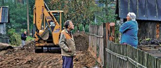
A dispute over the boundaries of a land plot is a fairly common situation that arises between owners of adjacent plots. Often neighbors cannot agree on where the boundaries of their plots lie and who owns specific land. The procedure for resolving conflicts over the boundaries of adjacent plots of land has certain rules and features, which should be considered in more detail.
Basic concepts and regulations
According to paragraph 3 of Article 6 of the Land Code of Russia (hereinafter referred to as the Land Code of the Russian Federation), part 7 of Article 38 of the Federal Law of the Russian Federation dated July 24, 2017 No. 221-FZ “On Cadastral Activities” (hereinafter referred to as Law No. 221-FZ), a plot of land is determined by part of the land surface having certain individual characteristics. The legislation establishes that, as the main identifying feature, a land plot must have precise boundaries determined during the land surveying process.
Land boundaries are the lines or edges that define the territorial location of a property. There are boundaries:
- Actual - currently available (fences, ravines, enclosures, other artificial barriers).
- Cadastral - taken into account during cadastral registration.
- Legal - determined as a result of the land surveying procedure, but before the site is registered.
- Historical - determined at the initial location of the plot.
- Decorative - taken into account by the state before land surveying.
In accordance with the above laws, land surveying is a mandatory procedure carried out when agreeing on the exact boundaries between adjacent land plots. Article 39.3 of Law No. 221-FZ states that the owner of a neighboring plot of land does not have the right to object to land surveying and prevent the establishment of clear territorial boundaries of the property. The procedure does not require additional costs from land owners and is carried out free of charge.
As a result of the process of delimiting nearby areas, an act is drawn up, signed by all interested parties. The document drawn up is the basis for entering information about border land plots into the Unified State Register of Real Estate (USRN).
Important: if the neighbors could not come to an agreement regarding the boundaries of their lands, further resolution of the conflict will require litigation.
Problem resolution algorithm
The algorithm for resolving disputes that arise regarding the boundaries of land plots consists of initially contacting a cadastral engineer, initiating the procedure for re-coordination of boundaries, preparing an application to the court, participating in a court hearing and making changes to official documents.
Contacting an engineer to draw up a report
The procedure for approving the boundaries of the plot of interest should be carried out exclusively through the participation of a cadastral engineer in such an action .
The owner of the site or another interested party contacts a geodetic company to carry out such a procedure, and a separately authorized engineer becomes responsible for drawing up a boundary approval act.
Renegotiation
In the event of a change in the existing boundaries of the allotment, even in situations where the existing errors have been corrected, it is necessary to initiate a re-coordination of the passing boundaries.
The scheme for carrying out such actions is standard - notifying all interested parties, holding a meeting and drawing up an official document .
Preparing a statement of claim to challenge
If it is necessary to go to court to protect their interests, the owner or user of the site must correctly draw up a statement of claim, according to the sample, which includes the following points :
- Name of the organization to which the statement of claim is sent;
- Indication of the plaintiff - the one who is filing the claim;
- Reflection of the essence of the problem - violation of property rights;
- A link to documentary evidence that confirms the need to resolve the dispute and, in fact, the very presence of inaccuracies in the documents;
- A reference to regulations and laws, according to which it is possible to resolve the problem in favor of the plaintiff.
In addition to the statement of claim itself, in order to challenge it, you will need to attach to it a list of necessary documentation :
- A copy of the completed application;
- Power of attorney (if the application is not submitted by the owner or user of the site);
- Receipt for payment of the state fee for filing a claim;
- Documents on the right of ownership or use of the site;
- Applicant's passport;
- Documents confirming an attempt to resolve the dispute out of court.
Court hearing
After filing a claim and providing the necessary documentation, an open meeting is scheduled , in which both the plaintiff who filed the application and the defendant in the existing land dispute can participate.
The submitted papers are reviewed, the testimony of all parties and additional invited witnesses in the case is heard.
After a debate between the parties, the court makes a decision, which, if the plaintiff or defendant disagrees with it, can be appealed .
Court decision and appeal to the rights registration authority for redistribution
After the applicant receives a court decision, according to which it is possible to revise incorrectly established boundaries or areas violated during operation, he has the opportunity to contact Rosreestr to make changes to the registration documents .
If the interested party is repeatedly denied, he has the opportunity to file a second claim again, although in judicial practice this happens quite rarely.
Causes of disputes over land boundaries
A dispute between owners of border land plots can arise not only in the process of determining the territorial lines of a plot (land survey), but also during its use.
The most common reason for disputes between neighbors is the discrepancy between the boundaries indicated in official documents and those that actually exist. In such cases, the boundary lot lines may:
- cross;
- overlap each other (overlapping the edges of the area);
- partially absent.
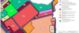
Table. Frequent cases of disagreements regarding the boundaries of land plots:
Why are there gaps between buildings?
The minimum permissible distances between houses are determined by the following circumstances:
- when residential buildings are in close proximity to one another, window openings are unprotected from prying eyes, which creates discomfort for residents;
- if the houses are located nearby, then in the event of a fire in one there is a real danger of fire in the neighboring house;
- when snow melts or heavy rains, sewage water will flood not only the neighboring area, but will also cause flooding of a residential building;
- the location of houses nearby creates dark areas where the quarantine weed grows. In addition, insufficient sunlight negatively affects living conditions in this part of the residential building;
- the excessive proximity of neighboring buildings makes it impossible to install a fence on the border of adjacent plots, since this will not allow free movement around the site.
Types of disputes and features of their consideration
The main types of conflicts arising over the boundaries of land plots are:
- Contradictions in the original documents are quite common, since the previous methods used in the land management process were not highly accurate, and their result was the determination of only approximate boundaries. In this case, new surveying will be required to establish precise boundaries, which often changes the actual lines of the site.
- An error made by a cadastral engineer when determining the initial edges of the plot. The situation arises due to incorrect measurements or erroneous entry of data into documents. As a result, there is a violation of the rights of the owner and the emergence of various disagreements between neighbors of adjacent lands.
- The most common type of dispute regarding borders is the seizure of land by the owner of the border plot, which can be expressed in the illegal transfer of a fence or fence, as well as part of the building, to a nearby land plot.
There are nuances when considering various types of disputes over land boundaries. Land surveying must be carried out with the participation of all persons interested in the process, or the fact of written notification of the date. If the procedure prescribed by law is not followed, the neighbors’ chance of resolving the dispute in their favor is significantly reduced.
Previously, before registering an allotment with the state, it was necessary to obtain consent from all owners of border plots. Now the procedure has been significantly simplified - in the absence of disagreements or the neighbor’s silence, the plot is put on cadastral registration. As a result, there is a possibility that the State Register will contain erroneous data. If the registration authority refuses to make changes to the Unified State Register, this can be appealed in court. You can challenge an error when registering a land plot for cadastral registration within three months from the date of refusal by the authorized body to eliminate it.
Possible reasons for disagreement
Disputes regarding existing boundaries of land plots can arise for a number of reasons. Depending on this reason the method of solving the problem , the possibility of revising the established boundaries, as well as the need to eliminate violations and bring to justice, if such action is provided, are determined.
Non-compliance with regulations
Separately, violations of norms that arise in the process of direct exploitation of land , these include:
- Violation of existing fire safety . Such points, as a rule, apply to objects erected for any purpose on a site, during the construction of which the current rules were not taken into account;
- Violation of building codes . When constructing objects on the site, it is necessary to take into account the currently valid rules and regulations regarding the parameters of the real estate. If they are violated, the boundaries of the plots may be partially affected, as a result of which there is a need to revise or clarify the boundaries;
- Violation of sanitary and hygienic standards . Such norms and rules may be ignored in the process of conducting communications or supplying certain resources to an object being built on the site.
Location objection
One of the most common moments of border violation is the seizure of neighboring land.
This action means that neighbors arbitrarily move the established boundaries and thus illegally use someone else’s territory.
In such a situation, on the basis of the provisions of Article 60 of the Land Code of the Russian Federation, a claim is filed and, in the course of the proceedings, the following facts are included as evidence of violation of property rights:
- The location of the border and the location before the seizure of foreign territory;
- Description of the essence of self-capture - determination of the area and related factors;
- The need to eliminate unauthorized seizure.
It is in the interests of land owners whose rights have been violated, upon discovering the fact of squatting, to immediately contact a notary to arrange a “notarial inspection of evidence” while the old boundary lines are still visible from the traces of the fence and other dividing elements.
Impossibility of mutual agreement
In the process of establishing boundaries, there must be a procedure for their approval.
It consists of notifying all interested parties about the place and date of the general meeting , at which the neighbors of the site, whose boundaries are being determined, get acquainted with the place where they will directly pass and, if there are no complaints, sign a special act as a sign of consent.
In certain cases, neighbors may have claims that cannot be resolved on the spot; in such a situation, the owner of the plot can initiate legal proceedings aimed at eliminating the problem of the impossibility of mutual agreement on boundaries and resolving a dispute between neighbors.
Construction on “free” land
The construction of real estate on so-called “free” land in almost all cases entails the need to resolve a dispute regarding the boundaries of the territory, which may be the property of a legal entity or individual.
First of all, the issue of the legality of such a building and the possibility of its further existence and operation is resolved, and subsequently the dispute over the boundaries of property is resolved.
Contradictions in documents
From time to time, in the process of accessing documents containing information regarding land plots, it turns out that they contain data that does not correspond to reality.
If it is necessary to change the information contained in such documents, the interested person must contact Rosreestr , and in case of refusal to revise and clarify the data, contact the court located at the location of the allotment.
Registry errors
One of the reasons for the emergence of disputes regarding the location of a site may be an error made by a cadastral engineer , due to which disagreements arise.
The essence of such an error may lie in incorrectly defined turning points, an error when setting out boundaries in nature, or incorrectly entered data on established boundary points.
The procedure for resolving such disputes consists in identifying the error itself , collecting the necessary documentation confirming the fact of inaccuracy and applying to initiate a procedure for revising the data on the boundary of the site or carrying out work to eliminate incorrect data and enter valid data into the documentation.
Which court should I go to with a land dispute on the boundary of a plot?
If a dispute arises regarding the determination of the territorial lines of a land plot and it is impossible to resolve the conflict peacefully, you must go to court. The jurisdiction of land disputes along the boundaries of plots is determined by law - such cases are considered by the district court.
The purpose of the trial is to determine and establish the exact boundaries of the land for its subsequent state registration with Rosreestr. To initiate the process of resolving a land dispute in court, it is necessary to file a claim and attach the available evidence. Upon acceptance of the application, the judge issues a ruling on preparation for trial. The owners of border areas and all interested parties must be involved in the process of considering the case in court.
Who sets the boundaries of lands adjacent to neighbors
The establishment of borders adjacent to neighbors is carried out by contacting a state or commercial organization that has the authority to determine the boundaries of allocated or only allocated land plots.
The direct work is performed by an engineer from a geodetic company or municipal cadastre department , while the owner can independently determine which commercial organization to contact.
The determination of boundaries on a free basis is carried out as part of complex cadastral works planned until 2021.
In the process of determining the boundaries of a plot, the engineer first familiarizes himself with the documentation provided by the owner or holder,, if necessary, sends inquiries about the location of the plots and subsequently travels to the location of the plot.
A visit to the site is carried out in order
to establish turning points , between which lines will be drawn, acting as boundaries.
During the process of establishing boundaries, errors may be made, which will cause incorrect data to be entered into the register.
In addition, in the process of using the site, other problems and issues may arise that provoke the emergence of disputes regarding existing boundaries.
The procedure for resolving disputes over the boundaries of a land plot
The main facts that must be proven when resolving a dispute over land boundaries are:
- determining the ownership of land plots by each of the parties to the dispute;
- contiguity of plots;
- actual change in land lines compared to those previously established and indicated in the documents;
- circumstances and reasons that served as the basis for changing the boundaries.
Important: in court, the plaintiff is obliged to prove the ownership of specific land to each of the participants in the process, while the defendant, for his part, must prove the absence of signs of illegal behavior in his actions.
During judicial consideration of land disputes along the edges of the earth, the following can be presented as evidence:
- title documentation;
- expert opinions;
- plans for border areas;
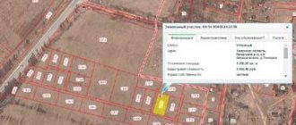
- general cadastral plan of the site with an appendix showing adjacent lands;
- other evidence (archival documents, witness statements, plans for the location of buildings, assessment of soil differences in areas).
To resolve a conflict regarding the territorial lines of adjacent land plots, special knowledge is required, therefore the most accurate evidence in court is the result of a land management examination.
When resolving a dispute, the court takes into account the boundaries that have actually developed and have been demarcated for more than 10–15 years before disagreements arose between neighbors. In most cases, such territorial lines are fixed by natural or artificial objects and have existed for more than one year, and sometimes even several decades. Such situations are common when land surveying methods were not quite accurate.
What is the limitation period?
If a citizen owned a plot of land, but did not use it for various reasons, this does not mean that someone is allowed to encroach on his plot. You can lose the right to own real estate or lose the right to a part of it only as a result of alienation or by a court decision that has entered into legal force.
The situation is different if the old-style certificate of ownership contains erroneous or inaccurate information. This is often why disagreements arise regarding the definition of exact boundaries.
It does not matter when the owner of the land became aware of the illegal use by another person of his land or part of it. If such information becomes known to the legal owner, he can go to court to demand clarification of the boundaries.
Regardless of how long ago the violation is, the true owner can try to resolve the dispute out of court. If the parties do not have a desire for a peaceful resolution of the conflict, the owner must go to court. To apply to the court, you need a basis - a document indicating the plaintiff’s right to the land plot.
The nuances of drawing up a statement of claim
When drawing up a statement of claim yourself, you should keep in mind the following nuances:
- the document must contain detailed information about the parties to the conflict. That is, personal data is indicated in full, and not in abbreviated form;
- before going to court, it is necessary to file complaints with local authorities and receive official responses;
- all written evidence is attached to the statement of claim in copies, however, you must have the original documents with you, since the court will definitely require them to be presented;
If experts confirm that due to the proximity of a neighboring house, cracks have appeared on yours, fungus and mold have formed, then you can demand the demolition of the problematic house.
Judicial practice on land disputes related to land surveying
The established judicial practice on land disputes is systematized by the Plenum of the Supreme Court of the Russian Federation. The most common mistake made by judges when resolving land disputes related to land surveying is violation of the procedure established by law:
- non-involvement of owners of adjacent lands as parties, which prevents a comprehensive and complete, thorough analysis of all available evidence;
- not assigning a land management examination.
For example, the district court heard a case in which the plaintiff’s demand was to invalidate the land surveying of a neighboring plot of land and the demolition of a self-built building in the form of a barn located on the applicant’s land.
Initially, the judge granted the plaintiff's demands, but later the decision was overturned by a panel of judges due to the lack of expert results in the case. A land survey carried out at the request of the defendant showed other territorial lines that did not affect the constructed structure. The claims were denied.
In another case, during the initial consideration, the co-owners of the disputed property were not involved in the case. The panel, overturning the decision of the district court, took into account that the land plot is in common ownership of several persons. During the re-examination, the court brought all co-owners on the side of the defendants.