The cadastral number of a property is a number that identifies a property. It is assigned by the rights registration authority when registering real estate for cadastral registration or entering information about a previously registered object into the Unified State Register of Real Estate.
To obtain information about the cadastral number of a property, it is enough to know the address of the property. Enter the city, street, house and apartment into the search bar, within a few seconds you will receive the general characteristics of the object, including its cadastral number.
Cadastral number: what is it and how to find it out?
To get complete information about an apartment, house or land plot, order an extract from the Unified State Register of Real Estate. The document will be sent by email within 30-60 minutes.
Order an extract from the Unified State Register of Real Estate!
Is it possible to find out the borders and coordinates of a storage unit only by its license plate number?
Plots of land that are located within the Russian Federation are subject to state cadastral registration. Each plot is assigned a cadastral number. It is presented in the format:
01:01:1000001:1, Where:
- 01 – code designation of the region;
- 01 - area;
- 1000001 – quarter;
- 1 – plot.
During the accounting process, the boundaries of the territory and its coordinates are determined. All interested parties, regardless of ownership, can obtain this information by cadastral number.
Coordinates from the USRN extract x and y
If you order an extended EGRN extract for a land plot, then in section 3.2 of the extract we will see information about the characteristic points of the boundaries of the land plot in the form of a set of numbers.
The coordinates in the Unified State Register are contained in the local system (in our example, the coordinate system is Moscow).
Is it possible to find the boundaries of the site yourself, knowing these coordinates and how to do it?
What is this data for?
The lack of information about the territory in the cadastre makes it impossible to register ownership of it, as well as to carry out civil transactions. Clarification of the boundaries of the memory may also be required in the following cases :
- dividing a large plot into several small ones or vice versa, combining territories into one;
- registration of the land plot for cadastral registration;
- the need to allocate the share of each owner when dividing property or entering into an inheritance (how to find out who the owner of a land plot is by its cadastral number?);
- resolution of disputes with neighbors regarding the delimitation of adjacent lands;
- collecting information about the land plot before its sale (about whether it is possible to sell land at cadastral value or lower and what the procedure and consequences of the transaction are, read here)
- detection of inaccuracies or erroneous information in documentation.
What do you need to know the layout?
To obtain a cadastral plan you must:
- Have information about the apartment. Either its full address or cadastral number is required.
- Check whether the property is registered in the cadastral register.
- If it is, order an extended extract from the Unified State Register. If you are not a member, register it, and only after that you can order.
The installation can be carried out either by the owner or by a long-term user.
How to check boundaries?
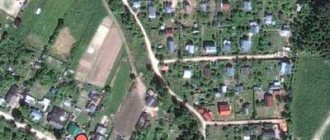
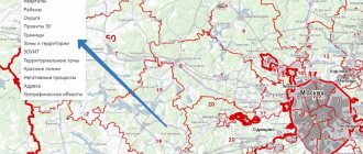
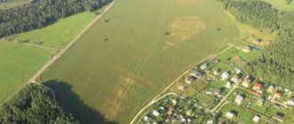
The boundaries of land plots are usually considered to be the lines of contact of the plot with other territories. The easiest way to determine boundaries is using the Public Cadastral Map (PCC) .
Its creation and updating is carried out by Rosreestr specialists, which guarantees that you receive up-to-date information. If necessary, you can save the found data in Excel. Users can see what the area they are interested in looks like, with the boundaries highlighted on one of the proposed maps:
- Google Maps.
Allows you not only to study a satellite map, plan or diagram on which the boundaries of the land plot are marked, but also to see a panoramic view of the area (read about what a cadastral plan of a land plot looks like here, about what a cadastral plan of a land plot is, where and how get it, find out here). The main advantage of Google Maps is the ability to take a virtual trip through the territory of any region. - Initially, this service stored information about city organizations and the buildings in which they are located. Later, 2GIS connected to the Rosreestr program and began to provide a schematic map of territories. This resource is created by users who upload photographs of sites into it. You won't be able to find cadastral markers here, but you can see photographs of the plots. This is especially useful for those who are thinking about buying land plots (read about who can buy land at cadastral value from the administration and the state and how to do it here).
- Yandex maps. They differ from PKK in a more comfortable scaling tool and the presence of not only diagrams of territories, including borders, but also their satellite images.
All of the services listed above allow you to find out the boundaries of the memory. The difference between them is only in the display of information, so everyone can independently choose which card to use.
To determine the boundaries of the allotment according to the PKK, you need to perform the following steps:
- Follow the link https://egrp365.ru/map/. The most current data is displayed here.
- In the upper right corner of the page there is a window where the user can select the desired card.
- In the menu, you can check the box next to the item “Show cadastral boundaries of plots”. In this case, a grid of territories will be immediately superimposed on the PKK.
- Oh, the user can select the criteria for displaying information:
- by cadastral value (find out about determining the cadastral value of a land plot in this material);
- by form of ownership;
- by category;
- on territorial zoning, etc.
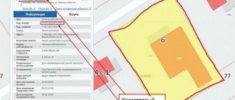
- After setting the parameters, you need to enter the cadastral number in the empty line and click the “Search” button.
- The requested area will appear on the map. If you click on it with the left mouse button, you can find out such data as the area of the plot, its form of ownership, etc.
Where to find?
First of all, it is necessary to clarify what a cadastral plan is. This is a collection of technical information relating to the apartment. The plan includes:
- full address where the property is located;
- number of storeys (both general for the house and the location of the apartment on a specific floor);
- the plan and footage of the apartment as a whole and each room in it, both residential and non-residential;
- designations of load-bearing walls and unloaded partitions, layout (both original and changes made after the housing was put into operation).
Read more about how to find out the layout of an apartment by address here.
Like other cadastral information, cadastral plans were previously part of the EKN. However, after the Federal Law “On State Registration of Real Estate” came into force, all information relating to real estate objects was included in the general state database - the Unified State Register of Real Estate (USRN).
How to view geographic coordinates?
Having become familiar with the boundaries of the territory, you can proceed to determining its coordinates, showing the exact location of the storage facility. It is recommended to do this on the official Rosreestr portal.
Through PKK Rosreestr
To calculate the coordinates of the memory yourself, you must proceed as follows:
- Go to the Rosreestr website https://rosreestr.ru and go to the PKK section.
- In the upper left corner there is a toolbar. You need to click on the “Magnifying Glass” icon. A search bar will appear designed to determine the location of registered plots. You need to enter the cadastral number there and click “Search”.
- The desired area will appear on the map. The borders of which will be highlighted in yellow.
- To zoom in, you need to find the “+” icon in the lower right corner and click on it the required number of times.
- By clicking on the corner of the plot, you will notice that the digital values in the search line have changed. These are the coordinates of the allotment. To obtain information about each of the turning points of the earth, you need to repeat this operation three more times.
Important! The data obtained at this stage is not suitable for determining the geography of the territory. Therefore, they need to be converted to another format.
According to Google maps
You can quickly convert the information received through the PAC into the required format using Google maps. To do this, you need to transfer the existing coordinates there and replace the commas with dots. After clicking on “Search” the user will see the result:
- You can once again examine the site itself, as well as the buildings and plantings on it. This will eliminate the possibility of error.
- The exact geographic coordinates specified during the search will be displayed on the left side of the screen on a blue background.
When determining coordinates, the error can reach 1 m . Its value depends on the device used. For example. You can get more accurate data via a PC than via a smartphone.
Rosreestr allows interested individuals and organizations to find and view information about the boundaries and coordinates of lands in any convenient way. If errors are found during the data verification process, it is necessary to re-survey the site and then make adjustments to the documentation.
Cadastral maps of the Russian Federation
Regions
- Amur region
- Arhangelsk region
- Astrakhan region
- Belgorod region
- Bryansk region
- Vladimir region
- Volgograd region
- Vologda Region
- Voronezh region
- Ivanovo region
- Irkutsk region
- Kaliningrad region
- Kaluga region
- Kemerovo region
- Kirov region
- Kostroma region
- Kurgan region
- Kursk region
- Leningrad region
- Lipetsk region
- Magadan Region
- Moscow region
- Murmansk region
- Nizhny Novgorod Region
- Novgorod region
- Novosibirsk region
- Omsk region
- Orenburg region
- Oryol Region
- Penza region
- Pskov region
- Rostov region
- Ryazan Oblast
- Samara Region
- Saratov region
- Sakhalin region
- Sverdlovsk region
- Smolensk region
- Tambov Region
- Tver region
- Tomsk region
- Tula region
- Tyumen region
- Ulyanovsk region
- Chelyabinsk region
- Yaroslavl region
Federal cities
- Moscow
- Saint Petersburg
- Sevastopol
Republic
- Republic of Adygea
- Altai Republic
- Republic of Bashkortostan
- The Republic of Buryatia
- The Republic of Dagestan
- The Republic of Ingushetia
- Republic of Kabardino-Balkaria
- Republic of Kalmykia
- Republic of Karachay-Cherkessia
- Republic of Karelia
- Komi Republic
- Republic of Crimea
- Mari El Republic
- The Republic of Mordovia
- The Republic of Sakha (Yakutia)
- Republic of North Ossetia-Alania
- Republic of Tatarstan
- Tyva Republic
- Republic of Udmurtia
- The Republic of Khakassia
- Chechen Republic
- Chuvash Republic
The edges
- Altai region
- Transbaikal region
- Kamchatka Krai
- Krasnodar region
- Krasnoyarsk region
- Perm region
- Primorsky Krai
- Stavropol region
- Khabarovsk region
Autonomous okrugs
- Nenets Autonomous Okrug
- Khanty-Mansiysk Autonomous Okrug
- Chukotka Autonomous Okrug
- Yamalo-Nenets Autonomous Okrug
Autonomous regions
- Jewish Autonomous Region
How to determine the coordinates of a plot of land using a smartphone
We have all been using GPS navigation for a long time. However, it is worth understanding that telephones operate on a simplified system and do not always reflect the area as it really is. Surely you have encountered at least once the fact that the navigator periodically “goes stupid” and gets lost on the road. The same thing happens when you try to find the desired coordinate on the ground.
In phones, cell towers are usually used to improve accuracy; in fact, this leads to an error of several meters. Of course, if the plot measures tens of hectares, then this deviation is negligible, but if you want to know the area or boundaries of a plot of 5-6 acres, then the difference in fact will be colossal.
If you still decide to use your phone and use it to determine the coordinates, then use a navigation program - save or write down the geographic coordinates of each point on the ground, and then using these coordinates, find the location of the site on the public cadastral map and make sure whether the actual boundaries coincide with borders of the map.