The cadastral number for each property is unique and is assigned only once. Without it, it is impossible to carry out various legal actions: buying and selling, donating, inheriting, etc. It contains a maximum of information; some differences exist between the cadastral number of an apartment (house) and a land plot.
The procedure for assigning and requirements for real estate numbers is prescribed in the Law on Real Estate Registration No. 218-F3. With its help, all real estate objects located on the territory of the Russian Federation are identified; it is necessarily indicated in all information databases of the relevant government structures and organizations. Depending on the region and location of the object, a certain division is applied (Order of the Ministry of Economic Development No. 877 of November 24, 2015):
• cadastral district of the Russian Federation; • cadastral district of the district; • cadastral quarter of the district.
Each unit is assigned its own unique number. If during an inventory or other actions changes are discovered in the boundaries or sizes of land plots, technical characteristics of permanent buildings, then appropriate adjustments are made to the new number in accordance with the decision of the special commission. Changes affect only those values that require updating; all others remain the same.
If several objects are combined, the cadastral number changes completely. Those numbers that previously belonged to separate objects are liquidated, and the newly formed one undergoes new registration in accordance with current legislation. Outdated conventional numbers were assigned before 2005; they are distinguished from the cadastral number by dividing marks. In the cadastral part, the numbers are separated by colons, and in the conditional part by hyphens.
Features of number assignment
Cadastral number is a unique digital sequence that is assigned to a real estate property when registering with the state. Unlike an address, such a code allows you to accurately identify a property and avoid confusion when conducting legal transactions.
The rules for assigning cadastral numbers are established by Order of the Ministry of Economic Development of the Russian Federation (Ministry of Economic Development of Russia) dated November 24, 2015 N 877 Moscow “On approval of the procedure for cadastral division of the territory of the Russian Federation, the procedure for assigning cadastral numbers, registration numbers, and register border numbers to real estate objects” . According to the Order, the entire territory of Russia is divided into cadastral units: districts, districts and blocks. The assignment of numbers in the cadastre occurs in accordance with this division.
The number assigned to a plot of land includes four parts, each of which is a cadastral division unit code. For example, the digital sequence 66:41:0313009:1669 carries information that the plot of land numbered 1669 is located within the block 66:41:0313009, where 0313009 is the block code, 41 is the district code, and 66 is the subject code Russian Federation (districts).
The cadastral number is valid until the plot ceases to exist: for example, as a result of division or merger with another plot.
How to use the public cadastral map
By default, the cadastral map has an appearance and background similar to the usual Yandex.Maps. At his discretion, the user can choose the type of display, among which are the following options: Yandex Maps, Google Maps, Yandex Sputnik, Google Sputnik and OSM. Basic cadastral map tools:
- Search bar;
- Card management;
- Measurement;
- Additional information;
- Reference;
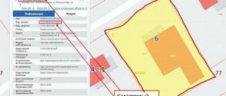
By searching for an object by cadastral number or exact address (or by pointing the cursor at the desired point on the map), the user will receive basic information about the found object, located in a drop-down window on the left side of the screen. The information will contain information about the cadastral units available on the desired site - buildings, structures, internal plots, their form of ownership and ownership of the land (the possibility of their intended use for certain types of activities).
Switching between substrates, modes and map layers will allow you to create your own map with areas belonging, for example, to one category of land or being the property of a specific legal entity.
A situation is allowed when the size of the area on the topographic map differs from the image from space. The reason for this discrepancy is different image generation algorithms for satellite images and the “flat” coordinate system used on cadastral maps. Such an error in the size of the area can range from several meters to several tens of meters. If fundamental differences are found, you should report the problem to Rosreestr specialists using the feedback form posted on the website.
Approaching the found area and switching to satellite image mode will make it possible to examine objects in detail, and also, if necessary, measure the required distances and plot them on your own map for later saving or printing.
A cadastral map is a multifunctional tool, the capabilities of which must be studied in practice. The main task of the cadastral map is to determine the presence of an object in the Unified State Register of Real Estate and check the compliance of the available data with the real state of affairs. For the modern real estate market, a cadastral map is a universal and indispensable tool for all categories of its participants, providing the opportunity to study a property before the official conclusion of a transaction. The cadastral map is available to users 24/7; its functionality is constantly supplemented and modernized taking into account market requirements and user wishes.
How to find a site by number
The cadastral number allows you to determine the exact location of the property.
To find a plot of land by number, just use an online service for checking real estate or a standard search on the portal www.rosreestr.ru.
For this:
- Enter the number in the search bar;
- Go to the property page.
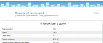
The page will provide general information about the site: full address, area, registration date and data update date, cost, as well as the number of owners and details of the registration certificate.
Please note that starting from 2021, all information about real estate, including state cadastre information, is stored in the Unified State Register of Real Estate (USRN).
Detailed information about the land plot can be obtained from the extract from the Unified State Register of Real Estate.
What is a cadastral territorial plan (CTP)
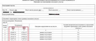
A cadastral territorial plan (CTP) is an extract from the state real estate cadastre, which displays all land plots and their coordinates within one cadastral quarter of your choice.
In other words, KPT duplicates the data of the public cadastral map of RosReestr, but indicating the exact coordinates of each object. In addition to the boundaries and coordinates of land plots, the CPT contains:
- Data on all capital construction projects (CCF) located in the quarter and their: cadastral numbers, address, category of land, permitted use, area and cadastral value;
- Graphic drawings of linear structures and their security lines;
- List of coordinates of all land plots and OKS with indication of boundary signs and the accuracy of their determination;
- List of coordinates of security zones of linear structures. In addition, it indicates exactly what restrictions are imposed within the security zones, which is important for owners of land plots with encumbrances.
Apart from the removal of encumbrances, the cadastral plan of the territory is unlikely to be useful to ordinary owners of land plots. However, you cannot do without a document when carrying out cadastral work. For example, KPT is ordered for land surveying.
I am ready to advise you free of charge by phone (24 hours a day, 7 days a week)
The call is free for all regions of the Russian Federation
How to remove encumbrances on a land plot
What is it and when is it necessary?
Geodetic surveys and data synthesis for drawing up a topographic plan must strictly comply with the established regulations .
In particular, the preparation of cadastral documentation must comply with the rules contained in such regulations as, “Instructions for topographic survey”, “Conventional signs for topographic plans”.
A topographic plan of a land plot is developed mainly for the correct calculation and successful preparation of design documentation for the construction of residential real estate and premises intended for production facilities.
Thus, a topographic plan
is required in the following cases :
- when developing a landscape project for a land plot;
- when developing communication lines;
- when legally registering ownership of land plots;
- when carrying out reconstruction of the facility;
- to obtain permits for housing construction, etc.
Smallest unit of division
The cadastral quarter of a land plot is the initial unit of land registration. Its identification is not conditional, but is based on the natural landscape of the area or is determined by man-made objects. Often the borders of the CC coincide with the boundaries of small settlements.
Each such territory is assigned its own cadastral quarter identification number, which will subsequently be included in the list of plots indicated in the Unified State Register of Real Estate (USRN).
Some data can be found at. In addition, a detailed map with the boundaries of objects has been published on this resource.
What to do if the apartment is not registered in the cadastral register?
If it turns out that the apartment is not registered in the cadastral register, then it is worth going through this procedure. To do this, you need to familiarize yourself with the list of required documents on the Rosreestr website and register the apartment using one of the convenient methods. This can be done online on the department’s website, at the MFC, the offices of Rosreestr and the Cadastral Chamber, as well as using on-site service or by post. The service will be provided within 5-12 business days. Its cost for individuals is 2,000 rubles.
What is copying?
A plot outline is a plan or diagram of a plot of land.
This paper summarizes in its contents all information about geodetic work carried out on a land plot, and also displays a wide range of geographical and technical information.
The copy is printed on A4 format in color or black ink; the contents include a site plan on a scale of 1:2000 or 1:5000.
A transcript of all pictograms and symbols on the diagram must be attached to the document. The document is intended for coordination of the design of capital or residential construction and is the basis for issuing permits or prohibitory documentation for construction. Also, the information in the boildown may be useful to the buyer of a land plot in terms of assessing the possibilities of carrying out agricultural work on it or understanding potential restrictions in the exploitation of the land.
Direct use of the document is made during planning:
- works on gasification, electrification;
- laying water pipes on the territory.
How to find out OKTMO
There are several options for correctly determining the current OKTMO code.
The simplest one: We go to the service of the official website of the Federal Tax Service, for which we click HERE. There you can enter your OKATO, click “Find” and the system will immediately display the required code. However, often, a person looking for OKTMO also has no idea about his OKATO. Personally, I am one of those. If you do too, go below.
In the field “Subject of the Russian Federation” we find ours. The example is the Republic of Tatarstan. The easiest way to navigate is by the region number (most likely it is marked on your car next to the Russian flag). To start selecting a region, you need to click on this nice button, pointed to by the red arrow:
Have you chosen? Great. Now in the “Municipal entity” field we enter not your registration or residence address! A city or place of settlement. Our example is Naberezhnye Chelny. We just start typing and the service itself will offer to choose from the list.
Attention! Selecting from the list provided is a necessity in this case! If you enter your locality and the system does not offer you a choice in the automatic list, you will not recognize OKTMO, or you will recognize it incorrectly.
Next, click the “Find” button and get your OKTMO:
We won’t talk about how you can make a request to local territorial authorities to provide information about your OKTMO. According to the scheme outlined above, this information is obtained a hundred times easier than working with any official requests to different departments.
What kind of error will it be?
If the OKTMO code is indicated with an error in the payment order (OKATO is entered instead or there are inaccuracies in the numbers), this will not lead to taxes not falling into the required budget. After all, there are also fields “KBK”, “Purpose of payment”, “Account number”, etc. with duplicate information. Therefore, an error in specifying OKTMO will not lead to the taxpayer’s obligation being unfulfilled, and therefore no fine will follow.
However, if an error was noticed, in order to avoid misunderstandings with the transfer of payments, you should submit an application to the tax office to clarify the details. You will have to go through the procedure of clarification and joint reconciliation of contributions. In this case, there will be no late fees or they will be written off, since the tax is considered paid on the day of its actual transfer, and not the payment confirmation.
But a declaration with an incorrect OKTMO will certainly require clarification: it will be considered erroneous.
Why is there no plot on the cadastral map?
- no surveying was done at all
- surveying was done a long time ago (before 2006)
- surveying was done recently (1-2 months ago)
- technical errors of the cadastral map
Print the map
The map shows only areas for which land surveying has been done (that is, the exact coordinates of the corners have been measured).
It must be indicated with colons and contain 4 groups of numbers.
For example, 77:08:0009005:8
land surveying was done recently 1-2 months ago.
It must be indicated with colons and contain 4 groups of numbers. For example, 77:08:0009005:8
Provide us with the number that contains the cadastral passport of your property, and we will make a quick request to the authorized authorities. Information will be given to us in a short time, thanks to direct access technologies. This opportunity was provided to us by the Federal Law of the Russian Federation.
Territorial land division
KK is part of the district, which in turn is included in the district. All these objects belong to territorial units of land division. Each one is assigned an individual number.
The cadastral region consists of land plots of administrative-territorial units of the state, which, as a rule, do not include water resources.
The district is a part of the territory of Russia with water bodies adjacent to it. Since it is the largest unit, its borders often coincide with the territory of the subject of the country.
How to obtain a territory plan from the MFC?
You can order boiling at any Multifunctional Center, for this you will need:
- come to the center in person and take a ticket to the queue;
- at the reception window, fill out applications based on documents (owner’s passport, cadastral number of the plot, land ownership certificate);
- receive an application for admission indicating the time of receipt of the scheme;
- come get the diagram.
This procedure is provided to citizens free of charge; the issued paper can be used by the owner in official real estate transactions, during design and construction on the site.