When the need arises to find out the owner of a property, you can get the necessary information online. It is enough to know the address or cadastral number of the property. A situation where you need to identify the owner of a house, apartment or plot may be necessary for the sale or purchase of real estate. The owner's data is needed when annexing a land plot or compensating for damage.
Check the owner of the apartment before purchasing
You can find the owner of a home or commercial property by address. It is enough to know the exact location of the house or registered plot of land to use the following methods:
- Apply for an extract from the Unified State Register of Real Estate online on the official website of Rosreestr. This method is the most reliable, but the speed of obtaining information can take several days.
- Contact the housing maintenance office. In this organization, the applicant is provided with archival documents with all the necessary information on the residential property. The data reflects all homeowners since 1998.
- Legal representative. If the applicant (potential buyer) cannot access information about the owner of the property, he has the right to authorize a notary.
- At the MFC. To obtain a certificate about the owners of the property, it is necessary to prepare documents confirming the identity of the applicant. You also need to pay a fee of 400 rubles. The response to the application comes within a few days. To obtain help, you can contact your local “My Documents” office, or create a request on the department’s website.
If the subject who wishes to obtain a certificate of homeowners is himself the owner of the property according to documents, he can obtain the data from the BTI (Technical Inventory Bureau). This right also applies to citizens registered in the same area as the owner of the property. Before contacting the Bureau, you need to pay a tax fee of 200 rubles. Application processing takes from 3 to 5 business days.
Method No. 3 - find the owner of a land plot on Avito
When the owner of a plot of land wants to sell it, the first thing he does is place an ad on the most popular website in the Russian Federation, Avito. As a rule, sellers indicate the cadastral number in the text, therefore, in order to contact the owner of the land plot you are interested in, just enter its cadastral number in the search line on the website avito.ru.
If there are no advertisements by cadastral number, then you can search for the desired site on the Avito advertisement map:
Open any advert for sale near the plot of land you are interested in and view the properties around it
How to find out the owner through Rosreestr - instructions
- Go to the single portal of Rosreestr and find the section “Reference information on real estate objects online.” This page presents different ways to obtain a certificate - by cadastral or conditional number, by restrictions and rights, by exact address.
- Enter the available data in the search field, click “Generate request”.
- In the window that appears, click on the address of the property highlighted in blue.
- In the field that appears, click “rights and restrictions.”
As a result, the applicant receives background information. It indicates whether the property title is actually registered. This can be understood from the information in the “Eligibility” field. If there is an owner, it contains a number and date.
Once ownership has been confirmed, you can order an extract from the Unified State Register of Real Estate to obtain detailed information about the owner.
You won’t be able to get an extract from the Unified State Register for free. Its cost is 250-400 rubles, depending on the type of certificate and the required data. From the moment you submit your application until you receive the document, it can take from several hours to several days. The period depends on the speed of request processing on Rosreestr servers.
From the USRN extract received online you can find out:
- Full name of the owner;
- Date of registration of the right to own real estate.
- The term of the mortgage loan, if any.
By the cadastral number or the exact address of the property, you can find out the owner of any real estate - an apartment, house, plot of land or building.
How to find out the cadastral number of a house by conditional number online
A conditional object number was assigned to buildings before 2000. It was indicated on the Certificate of Title. Popularly this document was called “greenback”.
Then the “greenbacks” were cancelled. Today, buildings are assigned a cadastral number, and the main document confirming ownership is an entry from the Unified State Register of Real Estate (USRN).
You can find out the cadastral number by conditional number only through the branches of Rosreestr. Today the easiest way to find out the cadastral number of an object is by address. This can be done for free online on the EGRN.Reestr website, but there are exceptions.
What is GKN?
The State Real Estate Cadastre is an information base containing data on all objects on the territory of the Russian Federation - plots and real estate objects.
GKN is a division of Rosreestr.
Main goals:
- Keep records of objects;
- Monitor borders;
- Carry out land surveying;
- Conduct an assessment of the value of objects.
In the process of accounting and registration of objects, an individual plot number is assigned, which contains data about the object, including its size and the material from which it is made, or the type of land on which it stands, as well as its value.
The specified number is called cadastral, since the basis for its formation is cadastral data on the location of real estate.
- The number is the basis for calculating the cost of the object and its justification.
- The number is confirmed by the fact of its registration.
- The number allows you to find out additional information about it.
Basically, cadastral numbers are of interest to potential real estate buyers, since with their help you can obtain comprehensive information about the property, including its official value.
Once every 5 years, the State Property Committee re-evaluates objects and re-evaluates their value. However, documents issued by the State Property Committee have an unlimited status, except in cases where the data of the object have been changed: redevelopment, division of the site, increase in the site, etc.
Submission rules
The procedure and rules for entering information into the state real estate cadastre are established by Government Decree No. 71 of February 3, 2914 “On approval of the Rules...”
There is one small but important subtlety in our legislation.
Citizens and individuals, when taking possession of real estate, register in the register not the property itself, the property belonging to them, but the rights to it.
The state manages the property of the country, including real estate. government agencies are engaged in registration (cadastral) and removal from it . The rules, first of all, regulate their actions.
The Rules clearly define who submits what information to the Cadastre. In relation to federal facilities - the responsibility of federal authorities . In relation to regional and local authorities .
The composition of the State Property Committee information about a real estate property, its structure, is determined by the Federal Law “On Cadastre”.
The procedure for establishing rights is determined by the general rules for their registration, other regulations, and the above-mentioned law.
Structure
The cadastre consists of several parts (sections):
- Register . It contains a description of all objects. Attention! Only electronic form of this document is provided.
- Cases (cadastral). These are documents on the basis of which property is entered into the register. Cases are divided into categories and types. For example, about the state border, its sections, territorial zones or real estate objects, etc.
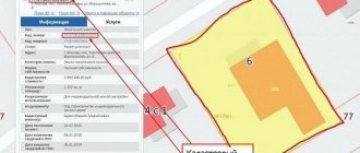
- Maps (cadastral). These are graphic images. For example, land plots, their boundaries, buildings, structures, etc. They contain, in addition to images, a text description (read about using a public cadastral map).
The cadastre contains information that describes real estate , its characteristics, changes, and movement of property rights to it.
The structure and composition of GKN is generally described above. Now let's take a closer look at the objects themselves.
In what form can I obtain information from the State Property Committee?
Depending on the situation: buying a house or selling it, resolving disputes with neighbors regarding the boundaries of a plot, etc., you may need certain data about the object. In this regard, the GKN provides the opportunity to obtain information in several forms, each of which differs in the volume of data and its privacy.
Cadastral passport
It is the main document reflecting data about the object. The legal significance of a passport is that in its absence it is impossible to conduct real estate transactions. Those. a passport is one of the required documents provided to register the transfer of ownership of an object.
Contains data on forms B1-B4:
- Cadastral number of the object . The number is unique and it contains the basic and main information about the site, house or apartment. The basis for generating the number is cadastral data: region, district and quarter of the location of the real estate (address).
- Information about dimensions (area);
- Material from which the building/apartment is made;
- Year of construction;
- Cadastral value.
Having structured the data according to forms, you can present it in the form of a table:
| No. | Form number | Content |
| 1 | 2 | 3 |
| 2 | IN 1 | Data about the object contained in its number - address and category of land, as well as information about the owner, cost, area, etc. |
| 3 | AT 2 | Site plan with a diagram, if land surveying was carried out. Otherwise, data in form B.2. will not be. |
| 4 | AT 3 | Information about the restrictions associated with the use of the object. For example, for land plots, there are restrictions related to the location of the object in a protected area, water protection zone, etc. |
| 5 | AT 4 |
- It is worth noting that only those objects that have been registered with the state registration authority - in the Rosreestr branch at the location of the object - have a passport. Otherwise, when applying, the object is first registered, and then its cadastral passport is drawn up.
Amendments to the legislation provide for the mandatory inclusion of data on the boundaries of the territory for plots in the passport. Without this information, it will be impossible to carry out any manipulations with the site related to its sale. This amendment will come into force in 2021. For this purpose, since 2015, Rosreestr has been conducting a total revision of borders.
Cadastral extract
It is formed on the basis of the data specified in the information base of the State Tax Committee. Roughly speaking, it duplicates the information specified in the passport. However, the extract contains complete data about the object. The list of information required to be provided is compiled by the customer independently.
- Information from the extract is necessary for carrying out land surveying work, as well as for clarifying the boundaries of the site in case of disputes.
The information in the extract is provided using forms KV.1-KV.6.
Having structured the data according to forms, you can present it in the form of a table:
| No. | Form number | Content |
| 1 | 2 | 3 |
| 2 | KV.1 | Data B.1 of the passport |
| 3 | KV.2 | Data B.2 of the passport |
| 4 | KV.3 | Data on the internal boundaries of the site, if it is divided. To be filled in if land surveying has been carried out. Otherwise - data in the form KV.3 - KV. will not be. |
| 5 | KV.4 | |
| 6 | KV.5 | Data on the boundaries of the site, as well as basic information about the neighbors: numbers, information about the owners, etc. |
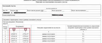
| 7 | KV.6 | Data on border turning points using a dual coordinate system. |
The main purpose of the extract is informative.
- Available for receipt even for those categories of objects that are not registered with Rosreestr. However, in this case, the extract will contain information only about the location of the site and its boundaries, as well as the fact that the object is not registered.
Cadastral plan of the territory
Contains information about the site, as well as objects located on it. Those. these are forms B.2. and KV.2. passports and statements.
It is mainly used by engineers to carry out cadastral and land surveying work; therefore, it is not particularly significant for other categories of persons.
- The legal significance of the territory plan lies in the fact that without it it is impossible to formalize ownership of land or an object, as well as to register it in the cadastral register.
The plan reflects to the smallest detail all the objects located in the described territory. The required attribute is an image with a clearly reflected boundary of the site.
The information in the extract is provided using forms KV.1-KV.6.
Having structured the data according to forms, you can present it in the form of a table:
| No. | Form number | Content |
| 1 | 2 | 3 |
| 2 | KV.1 | Data B.1 of the passport |
| 3 | KV.2 | Data B.2 of the passport |
| 4 | KV.3 | Data B.2-B.4 passport |
| 5 | KV.4 | Detailed close-up diagram of each part of the site. |
| 6 | KV.5 | KV.5 extract data |
| 7 | KV.6 | KV.6 extract data |
Cadastral certificate about the cadastral value of the property
A document drawn up according to the sample, reflecting the cost of the object.
- First of all, the cadastral number contains the value of the object. Since the number reflects information about the region, district and quarter, the territory on which the property is located. This is extremely important information when purchasing a plot of land or a country house, since the fertility of the soil directly depends on its location.
The certificate is issued for each of the objects separately. Those. if there is a house on the plot, then a certificate for the plot itself and the house located on it will be drawn up separately.
Data on the value of the object is updated every 5 years. However, in legal transactions, certificates whose validity does not exceed 1 year are accepted.
Copies of documents on the basis of which the information was entered into the State Property Committee
These could be:
- technical or boundary plan,
- administrative resolution on the basis of which a change in the permitted type of use of the land plot was made
- a document confirming the legality of changing the purpose of the premises or building,
- a document with information about the owner or address of the property, etc.
Payment for information from the State Tax Committee
Depending on the type of customer - legal entity or individual, the cost varies:
| No. | Name of service | F | YU | F | YU |
| Paper form | Electronic form | ||||
| 1 | 2 | 3 | 4 | 5 | 6 |
| 2 | Passport | 200 | 600 | 150 | 300 |
| 3 | Extract | 400 | 1200 | 150 | 300 |
| 4 | Plan | 800 | 2400 | 150 | 300 |
| 5 | Technical plan | 800 | 2400 | 250 | 500 |
| 6 | Others | 200 | 600 | 50 | 100 |
Nature of information
State cadastre data entered into the register can be recorded and temporary. Recorded information is real estate objects entered into the State Property Committee for which property rights have been established (state registration of ownership or lease rights has been carried out).
The information has temporary status - what does this mean? Information about objects for which rights are not set. They are kept in the register for one year, and on land for two.
If during this period property rights are not established (with the issuance of a certificate of ownership), then the information is excluded from the state cadastre (Cadastre Law, part 4, articles 24 and 25, part 5, article 24).