As a general rule, a public cadastral map of a particular region, region or locality should be in the public domain. Previously, such maps were available in the buildings of the cadastral service, and anyone could familiarize themselves with their contents. Today you can do this on the Rosreestr website. However, understanding the use of an electronic card is not so easy. You need to have a minimum of information about how to search for objects, what indicators mean, etc. So how do you use a public cadastral map to find the information you are looking for?
Search for objects on the map
You can use the card completely free of charge. First you need to go to the Rosreestr website, to the “Public cadastral map” tab. A complete map of objects subject to the cadastral register on the territory of Russia will open. On the left there will be a search line, where you need to enter the known data of the desired object. To find an object you can enter:
- cadastral number of the object (example: 47:25:109064:15);
- coordinates (example: 55.755768; 37.617671);
- address (subject of the Russian Federation, region (district), city (village)).
An important point is that the search is possible only by topographic coordinates. If you only have geographic coordinates, then they need to be converted into the appropriate system.
The site does not provide the ability to find objects by address down to the street or house.
So you'll have to scroll around the map a little to find the exact location of the object you're looking for. The resource contains a fairly large amount of information, so there are a lot of distractions.
For example, in addition to street designations, there are a lot of numerical values indicating blocks, houses, etc. If you notice that there is too much information on the map, for convenience, in the “Map Management” tab, you can limit the display of certain information.
How to order documents
As already indicated, in order to be 100% sure of the information, you need to issue an extract from the Unified State Register. order directly in the resource window. When ordering an application, you must pay the state fee on-line, provide the cadastral number of the plot and your e-mail for feedback, a link to the document will be sent to you. There is another possibility - to receive a paper version at the nearest branch of Rosreestr or State Public Property Committee or by mail. The application is completed within 15 minutes. The supporting document should arrive to the applicant within 2 to 5 days.
The amount of the state fee is determined by the type of document requested and the status of the customer. For individuals it is less than for legal entities.
For information on the rules for using the PPK, see the following video instructions:
What information does the card contain?
From this card you can get the following information:
- About the addresses of cadastre departments and their operating modes.
- About land plots.
- About structures, buildings, etc.
- On the territorial boundaries of various objects.
- General information about administrative units (region, city, etc.).
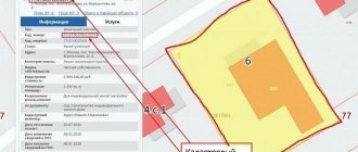
To find out information about a specific object, you need to find it and click on it with the left mouse button. All available information will appear in a pop-up window.
So, for land plots you can find out the following:
- cadastral number;
- value according to cadastral valuation;
- dimensions (area);
- category;
- type of use;
- address;
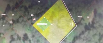
- plan (if there was land surveying);
- plan against the backdrop of all neighboring plots.
In turn, you can obtain the following information about buildings and structures:
We recommend that you read:
How to work with a topographic map correctly
- number in the cadastre;
- cost according to the cadastre;
- building area;
- legal status;
- address;
- technical inventory information;
- information about the type of property;
- number of floors.
It is worth keeping in mind that the data will be displayed depending on the availability of information about the property in the cadastre. If any data is missing, then either it does not exist at all, or it has not yet been entered into the database. In this case, you will have to order a cadastral extract.
Even if the data is available, you should not completely trust it. After all, the status of objects or other information on them can change at any day, and data on changes will be entered gradually.
Users have the option to save search results. To do this, you need to add the found object to your favorites list and save them on your computer. To do this, just click on the file upload icons. The file saved on your computer will be in “csv” format. This will allow you to later load this object onto the resource to update the saved file or for further work.
What is the cadastral number of a land plot?
The cadastral number (CN) of a land plot (LP) is a special unique code that does not repeat over time , consisting of several multi-digit numbers separated by a “:” sign and written in the format “XX: XX: XXXXXXXX: XX”.
Each of these numbers is not random and has its own meaning and interpretation.
A cadastral number is assigned when registering a land plot in Rosreestr.
In what documents is it indicated?
If you need your cadastral number, then it will not be superfluous to know in which documents it is indicated.
- Cadastral passport of the land plot;
- Any documents defining ownership of land.
If any legal transactions were carried out in relation to your site , for example:
- Purchase and sale;
- Rent;
- Registration of inheritance;
- Alienation of property, in this case a land plot;
- Donation, etc.
These transactions could not be carried out without registration, which means the cadastral number is already available and is registered in any of the documents drawn up for these transactions.
In some cases it may also be indicated:
- In cadastral terms;
- In terms of boundaries.
Color indicators
The “Map Management” tab has functions for color identification of objects.
In general, you can find out the following information from the color indicator:
- category of land and permitted type of use;
- price.
To switch between color themes and information that colors mean, in the “Map Management” tab, you need to check the corresponding “Land Category” or “Cadastral Value” box.
You need to keep an eye on the scale. If the scale is not large, then the necessary information and outline will not be reflected. Instead, the general outline of the area will be shown.
This is a very convenient function that allows you to more fully analyze the location of an object. For example, if there is a need to buy land in a particular area, having learned the data of neighboring plots, you can draw a conclusion about the prospects of the entire area as a whole. Or, having learned the category of a neighboring plot, you can guess about its future. It is possible that a high-rise building will rise next to your site, which, of course, you want to avoid.
Determining the meaning of the red lines on the cadastral plan
Receipt of documentation for the construction of a capital structure is accompanied by the issuance of a GPZU, the standards of which regulate the use of the allotment for construction. Based on it, the owner can accurately determine the location of each object, since the required indents are made from the red lines, according to established standards.
The design red line on the cadastral plan is used only to transfer the configuration of the site on the extract from the urban planning plan, within the limits authorized for use by the owner. Indicates to the owner the boundaries of his property from which to make indents and not to extend the fence beyond the marked red marks.
Operational card management
So, how to use public cadastral maps of Russia? First of all, it is worth noting that the public cadastral map has a wide range of functions not only as a source of information, but also as an Internet application. So, using normal actions you can:
We recommend that you read:
Symbols on topographic maps
- Lay out the map. To do this, you need to hold down the left mouse button and drag the map in the desired direction.
- Change the map size. This is done by pressing the Ctrl key and using the mouse wheel.
- When changing the scale, you can select a zoom point by double-clicking the left mouse button on the desired location on the map.
- Change the size of a specific map area. To do this, just use the mouse to select the required area of the map while simultaneously pressing the Shift key.
- View history.
Since the public cadastral map is updated almost daily, the previous version with outdated information on real estate is stored in the database. By looking at the history of the map, you can find out what category the site belonged to or who owned the building, etc.
In addition, the resource allows you to get acquainted not only with topographical information, but also with geographical data of the territory of the Russian Federation. This can be done both from satellite images and from academic information.
The ability to use an overview map allows you to use mutually exclusive tools without disabling the information display options you've already entered. Such a map opens in the form of an additional trimmed window that can be expanded to the width of the entire screen.
Cases of non-compliance
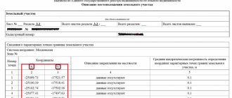
Inaccuracies in cadastral boundaries may be detected when viewing public online maps and extracts from the Unified State Register of Real Estate.
Inconsistencies are detected when compared with the cadastral map or cadastral passport issued when the property was included in the register.
The reasons may be both qualitative factors (actual shift of boundaries) and technical ones .
The latter are expressed in various types of errors and are classified on several grounds:
- On the content side:
- Technical errors. They are a consequence of an inaccuracy or failure of the electronic registration system made by an employee of the MFC, FKP or a cadastral engineer.
- Cadastral errors. They arise as a result of inaccuracies contained in the documentation submitted during state cadastral registration.
- By responsibility:
- Errors that caused damage to land owners. They entail civil liability for the person who committed it.
- Errors that did not lead to negative consequences.
- By source:
- Mistakes of officials of Rosreestr, employees of the Federal State Budgetary Institution "FPK", MFC.
- Problems with conversion when transferring data to electronic databases.
- Inaccuracies resulting from improper processing of information.
Methods of clarification
There are two areas of work for the owner to bring the boundaries back to normal: changing turning points with movement and clarifying without it.
The choice of course of action depends on the problem that caused it, as well as on its actual content regarding the area of the site.
With changing area
Moving characteristic points is often associated with a change in the actual area of the land plot.
The situation may be a consequence of several factors:
- Consolidation of land plots (parts thereof). The land must be a single integral piece of real estate used for one purpose. It can be formed as a result of civil transactions, as well as when part of municipal lands is annexed to private ones.
- Allocation of shares . Allowed if the common owner remains or when the secondary plot is transferred to a new owner.
The merger is accompanied by exclusion from the register of information about the absorbed land (if the entire plot was annexed). The allocation of a share, in addition to changing the boundaries of the main part, requires state cadastral registration of the newly formed object.
No area adjustment
Changes in boundaries not related to changes in area are carried out if errors associated with human or technical factors are detected.
The clarification proceeds in the general manner with the participation of a cadastral engineer and the drawing up of a boundary plan , but the area of the land plot does not change, since the position of turning points and boundary lines should not affect the integrity of the site.