A diagram of the situational plan with reference to the area is ordered along with a copy to provide information about the site in the event of its sale, as well as for connecting electrical and gas networks.
For a plot of up to 15 acres
Price from: 12,000 rub.
The price is valid until December 31
Call me back Calculate cost
What is a situation plan for the location of an object?
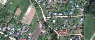
The designation on a map of the area of a land plot with highlighted boundaries, buildings located on it, communications, and adjacent neighboring territory is called a “situational plan.” According to the rules, all construction projects on it are accompanied by information about the date of construction, number of storeys, street names, and house numbering are indicated.
Wikipedia states that a situational plan is a contour plan that does not contain information about the terrain of the territory. In other words, it uses horizontal surveying to create it, as opposed to a topographic geobase, which includes displaying elevations. In addition, the application of various objects is carried out using conventional signs that are understandable to users without an engineering education.
Ready turnkey situation plan
Order
Reasons for obtaining SPZU
The document is prepared on the basis of the submitted application, with mandatory compliance with the following requirements:
- Legal capacity of the customer , which is confirmed by a certificate of ownership (another type of right) obtained from Rosreestr.
- The legal capacity of a plot for which the appropriate documentation has been drawn up, certifying that it is registered in the cadastral register and belongs to the copyright holder.
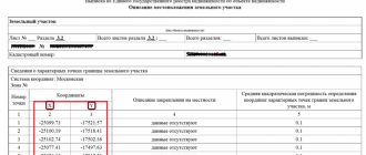
- Mandatory land surveying , with the registration of a land survey document containing a plan of the boundaries of the land plot and its coordinates.
If the site has not been demarcated, then it is necessary to first establish the boundaries of the land plot. To do this, you should know: What is land surveying and how much does the service cost? - What documents are needed for land surveying and what is the procedure for establishing boundaries?
And after that, if, when establishing boundaries, you did not have any disputes with your neighbors, the cadastral engineer will issue you a boundary plan, and the neighbors will issue an act of approval of the boundaries of the land plot.
Let's learn more about the boundary plan:
- What kind of document is this?
- What types of boundary plans are there?
- How to get it?
The decision to prepare the document is made by the authorized commission.
Application for connection of power receiving devices with maximum power:
- up to 15 kW: form, sample;
- up to 150 kW: form, sample;
- over 150 kW: form, sample.
When is it necessary?
To conduct a transaction of purchase/sale or lease of a property from the legal side, the situation plan is not a mandatory document.
Its presence is necessary to provide complete information about the boundaries of the site, the adjacent territory, nearby favorable and unfavorable areas, security zones, etc.
You will also need to order a situation plan in the following cases:
- obtaining permission to design and build a new facility;
- carrying out reconstruction of historical buildings, monuments;
- gasification, electrification of the site.
Legend
The correctness and accuracy of applying conventional images and abbreviations to the situation plan is regulated accordingly by GOST 2.854-75. For convenience, all symbols in the diagrams can be divided into the following categories:
Linear legends
They are used to indicate utility networks and communications.
They look like straight, dotted and curved lines of different colors and with different letter designations. For example, a blue (blue) dotted line with the letter “B” indicates a water supply system. Linear symbols indicate: roads, oil and gas pipelines, sewer and sewage mains, communication lines, power lines, etc.
Outline legends
Schematically depict scalable objects that occupy a certain area. And the contours are indicated by thin lines, repeating the configuration of objects. The drawn outline is filled with symbols. For example, dots of different sizes indicate bushes.
The following objects are depicted with contour symbols: forests and isolated trees, forested areas, meadows, swamps, cemeteries, continuous buildings, and the like.
Preparation of a boundary plan and everything related to it in our material. What is collective shared ownership and how is the size of shares determined in this case? Find out about this by reading our article.
When providing a plot of land for rent, an agreement must be concluded between the parties. You will find a step-by-step algorithm for handing over a land plot here.
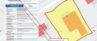
Situation plan by cadastral number online
After cadastral numbers began to be assigned to all real estate objects in 2007, transactions with them are only possible if this identifier is available. The number is issued once and is assigned to the site, regardless of the change of owner.
All information is stored in the Rosreestr database and is freely available to users, which, in turn, makes it possible to obtain a situational plan of a land plot using the cadastral number.
The package of documents for issuing a site situation plan at the MFC branch includes:
- application on a standard form;
- real estate documents confirming ownership, or an extract from the Unified State Register of Real Estate;
- identification documents.
Refusal
Cases of a negative decision are rare. There are three possible reasons for refusal:
- the information provided by the applicant has not been verified for authenticity;
- the area for which the situation plan was requested is located in the jurisdiction of another region;
- the package of required documents is incomplete.
The reason for the refusal will be stated. The missing papers should be collected, everything should be double-checked, and you should apply again. In case of refusal without specifying reasons, a person has the right to go with a complaint to higher authorities.
Plan for gasification
When agreeing with the operational services for connecting the site to the gas network, a mandatory package of documents is drawn up, which includes a situation plan with reference to local coordinates, drawn up on an A4 sheet. Information on the possibility of preparing a situational plan for gasification is provided by the local municipality.
To obtain a situational plan of a land plot by address, it is enough to indicate the exact coordinates of the location of the object.
In the absence of such information, it is necessary to contact a specialized organization that will produce a situational plan of the land plot on a scale of 1:2000 after performing a topographic survey for gas.
It is also possible to prepare the document yourself. The basis is taken from high-resolution maps from open sources. Before this, it is necessary to notify the operational services in advance about independently drawing up a situational plan for the land plot for gasification.
Methods for obtaining a document
Individuals or legal entities can obtain the document in 2 ways - from the municipal authorities of the region (in the administration, MFC, through State Services, in a geodetic organization) or by ordering it from a design company with the appropriate license.
The most convenient way to obtain a situational plan is to contact. Here they will tell you in detail what documents you need to collect, make copies of them, and in addition, they will help you fill out the application and suggest further steps.
Despite the fact that municipal authorities will provide it free of charge (for individuals), unfortunately, not every region provides such a service. You can check this opportunity in your region on the State Services website or during a personal visit to a government agency, if such information is not noted on the portal.
If you choose this option, you will need to submit your application in one of the following ways:
- Upon personal appearance at the institution.
- By power of attorney or through a legal representative.
- Through the postal service.
- By calling or writing by email.
It should be understood that regardless of the method of submitting the application, you will have to provide documents in person. Or it’s worth clarifying this point during a phone call.
You can also receive results on the readiness of the plan or refusal to prepare it in person, through a representative of the municipality.
The State Services portal provides detailed information regarding the collection of documents, the procedure and rules for submitting them for the issuance of a situational plan. And also, only possible violations in the collection of documents are indicated as justifications for refusal, so there should be no problems with registration
Upon receipt of the application, its registration is carried out within 1 business day. The period during which the result of the request appears is, as a rule, 10 calendar working days; the situational plan of the land plot will be completely ready within 30 days.
You can see what the situational plan for gasification looks like here.
Of course, the document is not simply issued. To do this, you must provide the municipal authorities with:
- Passport - original and 1 copy (often photocopies are made by the administration employees themselves, but this point needs to be clarified). Under no circumstances should it be sent by mail or left with administration employees. After viewing information about the applicant or making copies, the passport is returned to the owner. At the same time, when submitting documents remotely, first clarify the possibility of sending only copies.
- Application in original and 1 copy.
- Power of attorney, if the application is submitted by a guarantor.
- TIN (if you are a legal entity) in the original and 1 copy.
- Title documents for the land plot or registration certificate from the BTI.
- Extract from the land surveying plan.
- Plan of the future house, if it has not yet been built, as well as a building permit.
It is better to check the detailed list for your region in advance by calling the municipality.
To submit an application online through the State Services portal, you must first register on the site, if you do not yet have an account; if you do, log into your account using your password and login.
Check to see if you have already been registered on the State Services portal during previous visits to the MFC or other institutions. Usually the link is to a phone number or email
Next, you need to find a form to fill out an application and send scans of documents. Don’t forget to indicate how you will receive a response—email, personal visit, or regular post office.
At the MFC, the service is provided during a personal visit. To do this, make an appointment in advance for a convenient time or simply take a coupon and stand in the “live” queue.
For some reason, you may be denied the development of a document. This can happen if you have not provided all the documents or they are damaged, you are not authorized to represent the interests of the owner of the site, or the application is filled out incorrectly.
The application itself is filled out according to the approximate template issued to you by the organization. It indicates the personal data of the applicant - full name, series and number of the passport, who and when issued this document, address and contact telephone number, address of the land plot, its area, cadastral number. The purpose is also indicated - for individual housing construction, private household plots, and so on. Don’t be afraid to ask a specialist if you doubt whether you have filled out any part of the form correctly.
This is what an application for a situational plan looks like.
In case of refusal, you will be given or sent by mail a written notice indicating the reasons for the refusal, the institution’s seal and signatures. If you do not agree with the refusal, you can appeal it in court, but, as a rule, there are no special problems with this.
Registration in a private company
If for some reason you do not have the opportunity to contact a town planning organization or your municipality does not provide such services as a way out, you can contact any private company specializing in geodesy and licensed for such work.
As a rule, private companies provide a situational plan of a land plot within a maximum of 14 days, with light load - up to 3 days. It is worth noting that the municipality develops a document free of charge only for individuals; legal entities should compare the prices in both options.
On average, the cost of a turnkey drawing ranges from 5 to 20 thousand rubles, depending on its complexity and the organization’s prices.
Be careful, very often when contacting a company for turnkey gasification, the cost and procedure for drawing up a situation plan is included in the list of services. You should carefully read the price list for the concluded contract so as not to overpay for an extra document that they will prepare for you anyway
Before contacting a private company, be sure to check all the company’s documents and licenses.
The procedure for drawing up a situational plan in a private organization is approximately as follows:
- analysis of the land plot and customer needs;
- calculating the cost of performing services and drawing up a contract;
- specialists visiting the site for reconnaissance, topographic survey, and so on;
- drawing up graphic documentation and its copies.
After this, the company issues the finished document to the person who ordered it.
Independent drawing up of a situational plan
Many people are interested in the question of whether it is possible to develop a situational plan for gasification on their own, using a sample, and then simply approve it.
This desire is not entirely clear, because these are complex engineering calculations, the need to know exactly the location of communications, and have drawing skills. However, many are trying to do this and even post master classes on how to create them on the Internet.
Using samples and drawing programs, you can make a situational plan yourself. However, this requires complex engineering calculations and surveys. Moreover, such a paper will not be accepted for consideration.
Let us immediately note that solely for personal needs or a rough idea, you can draw up a situational plan. There are even special programs, samples from the Internet. But it will not be legally certified by any authority.
This issue is regulated by the Town Planning Code, Article 48, paragraph 4. It states that all such work can only be carried out by specialists in architectural and construction design. Which is quite logical and understandable, because according to this plan, technical conditions will be developed for you and, in general, a gas supply project will be developed.
Ground plan for electrical grid
An application to connect a site to the electrical network must be accompanied by a plan for the location of power receiving devices. The document contains two parts: text and graphic. The latter is a map-scheme M1:500 on an A4 sheet.
When drawing up a situational plan for electrical networks, you must indicate:
- clear boundaries of the site;
- main and secondary buildings;
- ground and hidden utility lines;
- power lines with external power supply;
- cable markings, protective equipment, grounding points.
You can obtain a plan for the location of energy receiving devices by cadastral number from the Rosreestr database.
Turnkey electrical plan
Order
Step by step guide:
- To do this, you need to register on the site and send the appropriate request.
- Next, the resulting situational diagram must be scaled to 1:500 and saved electronically or printed.
- Then find a sample situational plan for connecting electricity and, using a graphic editor, identify nodes and power lines on the site.
But it is worth noting that municipal energy service workers may not accept such an EPU plan for connecting power grids.
You can order the production of a document from organizations providing geodetic services. Specialists will take measurements, draw a diagram of the location of the control unit and compile a descriptive section.
What information is displayed in the EPROM?
This document reflects topographical information in the form of a diagram of the land plot and the surrounding context of the development area, with previously installed power lines . The source of electricity from which electricity is transmitted and where it is planned to branch off the electrical wires is also indicated here. In this case, the following conditions are met :
- lack of boundaries between the territory of the site and the external context;
- schematic design of adjacent sidewalks, transport lines, residential and public buildings;
- some elements of engineering infrastructure related to the electrification of the site.
The listed conditions create a connection with the development zone and are called connection to the territory.
Where can I download it for free?
Sometimes the legislation of local municipalities allows for the independent preparation of a situational plan according to the cadastral number. You can download the document from the Rosreestr database or compile it using maps from Yandex and Google services. Certain requirements are put forward for such a situational plan:
- presence of all necessary symbols;
- compliance with a given scale;
- supporting the data shown in the diagram with an explanatory note.
The difference between a situational plan and a general plan is that it contains relevant information at the time of preparation. In addition, the diagram is drawn up on a scale of 1:500, 1:2000, 1:5000. The master plan is prepared on a scale of 1:200, 1:500.
Where can I order a situation plan by address?
The architectural department is preparing a situational plan for a site in the Moscow region. In Moscow, issuance is carried out by Mosgorgeotrest.
You are required to print out a land plot plan by cadastral number free of charge within 3 days after applying.
It is worth considering that information in government databases may be outdated, and you will have to independently enter current information into the document.
In particular, this applies to real estate in the Moscow region. The situational plan of the site in Moscow may contain more up-to-date information due to frequent database updates.