Sometimes landowners need to search for certain data about a plot of land or other real estate.
One of the modern and convenient ways to do this is to view the necessary information on a satellite cadastral map.
The purpose of its use is to obtain various register data and the ability to view the appearance of a land plot or other property.
What is a public cadastral map of the Russian Federation
On this map, the user can clarify current information, as well as the exact number of real estate objects at the moment. There is also information on types of property. The public cadastral map helps to find out all the general information. It is enough to enter the cadastral number, and each object has its own. Such important data will open as: cadastral number, registered area, year of construction, as well as location coordinates accurate to degrees. Tracking on the territory of the Russian Federation is carried out from satellite. He evaluates the surrounding infrastructure, as well as adjacent lands and objects.
Below the map there is also a list of all regions and the city so you can narrow down your search area. You can also order a report on the property or see what rights are available to transfer it to another person and calculate the cadastral value. An extract is also issued.
More details about the public cadastral map can be seen in this video:
How can you find out the cadastral value of a land plot or real estate?
The cadastral value of real estate is necessary when you need to calculate taxes, divide property, or make a transaction with another person regarding real estate. The cadastral value is the amount below which, in theory, you cannot sell your land.
To find out in detail how to find out the cadastral value of a land plot or real estate, you should go to our official website and see the latest information and do a few steps:
- It is necessary to enter the cadastral number or address of the property in the search line on the map. You must enter information on the service itself, in the “Public cadastral map of plots” item;
- Next, you need to click on the “Find” button, after which a window will open. It contains a brief description of the object, including the cadastral number, full address of the object, type, area, and so on;
- To find out the cadastral value, you need to issue a certificate. On the server itself, you can send a request, which will represent the document. The cost of the certificate is 219 rubles, and the execution time is only 3 working days. It is possible to order a cost document for the desired date;
- The completed certificate of cadastral value of land or real estate will be automatically sent to the user’s email.
Is it possible to find out the purpose of the land plot?
The purpose of a land plot must be determined when the user needs knowledge about the type of property or territory. The steps are simple:
- First you need to search using the cadastral number or by entering the address. All relevant information will appear on the search bar;
- Next, tap on “More details”. This line contains information about what kind of land it is, what types it has, and so on.
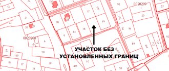
Lack of allotment boundaries
Cadastral boundaries of land plots may not be in the register; accordingly, they are not present when viewed on the map.
There are several objective reasons why this situation arises:
- The land survey was completed before 2001. The current procedure for carrying out geodetic work and land surveying appeared in 2001. Plots to which a cadastral number was assigned before the new accounting system was put into effect are registered, and information about them was not entered into the Unified State Register of Real Estate.
- The entry in the register does not contain clear boundaries of the allotment. Recognition of the boundary plan as invalid entails exclusion of information about turning points from the register.
- The land plot is not in the Unified State Register of Real Estate.
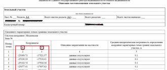
How to correctly find out the coordinates of a land plot by its cadastral number
Using the cadastral map you can easily find out the exact coordinates. Exact boundaries are set using land surveying. Situations often arise when the user needs certain clarifications. To resolve the issue, you need to use the public cadastral map on the website. To find out the coordinates, you should:
- Find the area on the map whose coordinates you would like to know;
- After clicking on the “Details” button, all coordinates of the site are displayed.
How to Check the Size of a Plot with a Cadastral Size
After submitting the entire package of documentation, the citizen receives a receipt, which will need to be presented to receive a cadastral passport. By clicking the “Find” button, the user will see that the map in auto mode will find and show the boundaries of the storage area in yellow, and in the adjacent window that appears, information about the object will appear, including the area defined in square meters.
The map shows only areas for which land surveying has been done (that is, the exact coordinates of the corners have been measured).
By clicking on a section of the official map, you will find out the cadastral number of the object, area, purpose, year of construction (for the house) and can go to view all available electronic extracts from the Unified State Register of Real Estate.
Is it possible to see the location of a plot by cadastral number?
Yes, the user can view the location of the plot using the cadastral number. To do this, you need to look at the information on the map, and you can see both the shape and the infrastructure that is located nearby, see the location relative to other objects, and so on. To do this you need:
- Find the plot of land that is needed, and enter the cadastral number into the search bar on the website;
- Next, use the navigation buttons to set up the required object. You can zoom out and see its location relative to other infrastructures and objects;
- Next, it’s worth looking at what zone the site is located in. To do this, you need to follow the diagram on the left. We select the “Thematic map” items, after which we find areas with special conditions for use.
This way you can easily and quickly see where the site is located. This way you can simply use the cadastral number.
How to find a land plot by cadastral number
A unified cadastral map can find a land plot even using its number. In order to easily find a plot of land, a person will need a cadastral map and cadastral number. The cadastral number can be found using the USRN server. To find it costs:
- Click on the top search bar. In it you need to enter the coordinates of the land plot by cadastral number;
- Tap on “Search”. The system will automatically display the location of the object on the map. Full information will be provided. Including legal status, category, location address, area and much more;
- If the user needs information, he can click on the “View available documents” item and ask for the necessary ones. On the site you can find many options for documents, including various reports and certificates.
Basic methods
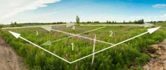
There are three main ways to determine areas:
- analytical;
- graphic;
- mechanical.
When using the analytical method, the area is determined based on the results of field angular and linear measurements (or coordinates) of characteristic points.
For the graphical method, measurement data on the plan and map are used.
This method is most often used in the absence of field measurement information.
With the mechanical method, the area is determined according to the plan using a special device - a planimeter.
Sometimes a combined method of determining area is used. For example, the total area of a site is determined by the coordinates of characteristic points in an analytical way, and the areas of internal sections are determined according to a plan using graphical or mechanical methods.
These three methods have different accuracy rates.
The most accurate is the analytical method. The accuracy of this method is affected only by field measurement errors.
The accuracy of other methods that use topographic information from plans also depends on instrument errors, plan quality, scale, and paper deformation.
Analytical method
The analytical method allows us to determine its area using the coordinates of the characteristic points of the boundaries of the site. In this case, formulas of analytical geometry are used.
In accordance with them, the area of the polygon S can be determined by the formula:
S= 0.5*∑(Xi*(Yi+1-Yi-1), where:
- Xi and Yi are the coordinates of the i-th characteristic point of the area, which has the form of a polygon;
- i is the serial number of the characteristic point of the memory. This parameter varies from 1 to n;
- n is the number of characteristic points.
If the site has a quadrangular shape, then, in general, the area for it is calculated using the above formula, taking into account the fact that n=4.
If a plot has the shape of a trapezoid and its sides are known, then the area of such a plot can be determined by the formula:
St=0.5*(a+b)*h, where:
- a and b are the bases of the figure;
- h – height of the trapezoid.
When calculating an irregularly shaped quadrilateral, when the dimensions of its sides are known, first determine the value of the semi-perimeter p:
p=0.5(a+B+c+d), where:
a,b,c,d—side sizes.
Then the area of the plot Su will be equal to:
Sy=√(pa)(pb)(pc)(pd).
In some cases where there are many turning points, an analytical calculation of the area of the site is made using azimuth angle data.
In this case, the azimuth of each characteristic point is measured along the contour of the site boundaries. The distance from one characteristic point to the next point after it is also determined. All this information is subsequently entered into a computer, which, using a special program, calculates the storage area.
Graphical method
When calculating the area of a plot using a graphical method, most often a plot of complex shape shown on the plan is divided into sections of an elementary form (triangles, rectangles, trapezoids), then the areas of these figures are calculated and summed up.
The accuracy of the graphical method depends on the accuracy of the graphical measurement on the plan. It is known that the accuracy of measurement using a compass is constant and equal to 0.1 mm. Therefore, the relative error when measuring short lines is greater than when measuring long lines. In this regard, it is desirable that simple figures be large in size and with bases and heights that are similar in size.
This method is convenient when there are a small number of characteristic points. Otherwise, it is more expedient to determine the area of the site by the coordinates of the points measured on the plan.
In some cases, areas have a curved shape that is difficult to approximate with simple figures. In such cases, palettes can be used.
The palette is a transparent sheet on which divisions are applied. This sheet is superimposed on the site plan. By counting the number of divisions included in the contour of the site and determining the area of one division taking into account the scale, you can estimate the area of the site.
The disadvantage of this graphical method is that the number of incomplete squares has to be estimated by eye. As a result, the accuracy of this method deteriorates.
Mechanical method
The mechanical method is used in cases where, according to the plan, it is necessary to estimate the area of a large area with complex boundaries. To implement this method, planimeters are used.
A planimeter is a device that allows you to determine the area of a flat figure by tracing its outline. It consists of two levers and a carriage with a counting mechanism. The pole arm has a needle that sticks into the plan and is the pole. A bypass spire moves around the pole along the contour of the site. The accuracy of the method depends on the size of the site and the properties of the plan.
Is it possible to see the free area on the map?
Using the cadastral map you can easily find out where this or that vacant plot is located. To do this, you need to perform a couple of steps. In the future, knowledge of the vacant territory will help a person understand where it is easier to build a plot or certain real estate, what is the cadastral value of the territory, and so on. There are a few steps to follow to find out:
- To begin with, you should select the area within which the search for land will take place;
- Use the checkbox on the right to mark “Thematic map”. A list will open in which you should select the item “Form of ownership of the site”;
- Next, the areas will take on a certain color. For example, pink is a private territory, and purple is a territory occupied by public legal entities;
- Those areas that are not painted at all are free areas that can be useful to the user for their future buildings.
Thus, you can quickly and easily find an area that is not occupied in any way. An open cadastral map will help with this.
Offset boundaries
Checking characteristic points of land plots often leads to the discovery of inaccuracies. There are several types of inconsistencies, each of which must be eliminated in the manner prescribed by laws and regulations.
Changing cadastral boundaries allows for two procedures: pre-trial and judicial . The first situation involves clarification, carried out through geodetic work, by mutual agreement of the owners of adjacent plots.
To carry out these activities, a qualified cadastral engineer is required, who can be found using a special search form on the Rosreestr website.
Having completed geodetic work, the engineer draws up a boundary plan. You need to contact the territorial division of the Federal State Budgetary Institution "FKP" or the MFC by filling out an application for making changes to the Unified State Register.
The court procedure is the only correct solution if one of the owners does not admit the mistake.
Depending on the situation, the owner of a plot with incorrectly established boundaries has the right to make the following demands :
- on making corrections made when registering land;
- about the need to oblige the other owner to make changes to the Unified State Register;
- on invalidating the results of geodetic work.
As evidence, it is necessary to provide a boundary plan , as well as documentation that contains information corresponding to the actual state of affairs. If a positive decision is made, Rosreestr independently makes changes to the cadastre, notifying the second owner.
How to check or find out the cadastral number using the address
For such manipulations, there is a fairly convenient server that helps you find the cadastral number only by entering the address. To get complete information about the cadastral number, you should follow this algorithm:
- We go to the desired page of our website and fill out all the fields that are proposed in the forum, namely: region, locality, address. All parameters must be selected in the list that opens. By entering the first letters, the user will find exactly the address that is needed and indicated in the directory. The street and house are indicated, and information about the apartment is also available. You should also fill in her number to provide all the necessary user data;
- We click on the “Find” button, after which the service compares the Rosreestr data with the results that the search produces. The People's Map helps with this;
- If the user needs to fill out a report, then just click on the “Select object” item, read the data and click on the list of documents that the user needs for further use.
This is a fairly simple algorithm, thanks to which you can find out the cadastral number using the address. There is nothing difficult if you use the right servers. Some people do not understand how to use the “Rosreestr” of the Russian Federation, however, for such cases there are online services that are convenient and provide the necessary information quickly and easily. The land cadastral map is designed to solve such problems.
Entering information about missing boundaries into the Unified State Register of Real Estate
The procedure for placing information about cadastral boundaries in the register is determined depending on the reason for the absence.
The list of such reasons was given above in this article.
To include in the Unified State Register of Information about the turning points of a site registered before 2001, it is necessary to carry out standard registration in the divisions of the Federal Cadastral Chamber with the attachment of existing documents without carrying out new work.
The presence of information about a site without cadastral boundaries entails the need to repeat geodetic work.
The new boundary plan is attached to the application and title documents. In a situation where there is a complete lack of information in the register, it is necessary to complete the entire range of cadastral work and carry out registration in the general manner.