A cadastral passport is information about an object displayed in an extract from the state real estate cadastre.
A passport is an additional document confirming property rights, and from January 2021 it is provided in a single form in the form of an extract from the Unified State Register of Real Estate.
Cadastral passports do not expire, and after the innovation, those who have a document of a canceled type in their hands do not need to receive new ones.
A cadastral passport is required when surveying a land plot, making any transactions with land, registering property rights insurance, and construction.
Based on the document, you can check the accuracy of the land tax calculation; thanks to the extract, you can see information about the encumbrances applied.
The document is regulated at the federal level and is drawn up in accordance with regulatory standards.
Components of the document
The cadastral passport has four numbered sections in A4 format.
- Information about the main characteristics of the property;
- Information about registered rights;
- Description of the location of the property;
- Description of the location of the property.
The cadastral plan is a mandatory component of the cadastral passport. After studying this application, no questions arise about the description of the property and the characteristics of the cadastral quarter.
The certificate is a display of an expanded format of public information about property rights .
The document contains information:
- by land area,
- copyright holders,
- cadastral value,
- detailed, onerous or prohibitive information,
- cadastral plans of territories,
- exact coordinate points.
You can receive a passport in electronic form or on paper by contacting the Rosreestr authorities in person or by submitting a request through the portal.
Composition and contents of the passport
The structure of the document is drawn up in accordance with the forms of which it consists, and looks like this:
1. Cadastral number. Depending on the date of registration, it may be written as follows:
- separated by a colon - for a modern document sample;
- with a hyphen - for the old style.
It is worth considering that this characteristic is individual, so each plot has its own number.
2. Sheet number. It is indicated if all the information on one form does not fit on one sheet.
3. The total number of sheets of the form.
4. Previous cadastral number. For example, it could have been changed as a result of some transformation that occurred with the site (its merger or division). Indicated only if available.
5. Date of entry of the new number into the state register.
6. Address of the site (or its location, if the exact address is not available).
7. Land category. This characteristic is very important, since many of the owner’s capabilities depend on it, for example:
- the ability to register in a house located on the site;
- cadastral value;
- the amount of property tax.
This paragraph also does not always contain any information, but only if the category of land has been established.
Otherwise there will be a dash.
8. Permitted Use. This clause is needed so that the owner knows for what purposes he can use his allotment (for example, only for gardening or housing construction). Moreover, these goals must be adhered to, because certain liability may be applied for the inappropriate use of land.
9. Actual use. It is logical that this section should be filled out in accordance with the previous one (or at least within the framework of the purposes indicated there).
10. Area. The accuracy of its indication depends on whether land surveying was carried out in relation to the allotment or not. In the latter case, the area is indicated exactly, and in the second - within certain limits (for example, 50 m2 ± 2 m2).
11. Cadastral value. In fact, this is exactly the price at which the plot is valued. In particular, real estate tax is charged on it. It can also be taken into account if land is used as authorized capital or collateral. In practice, it is almost equal to the market one, but may differ significantly from it.
12. Price per m2. It is calculated by dividing the previous value by the area of the plot.
13. Coordinate system. It contains data that is understandable only to specialists in the geodetic field.
14. Information about rights to the site. This paragraph indicates the owner’s details (his full name), the type of right under which he owns the property, as well as documents confirming this.
15. Special marks. For example, it is noted here whether the land was
land surveying, as well as in which cadastral quarter it is located.
16. History of the site (for example, the fact of its division or merger).
17. Site plan (if available).
18. Information about restrictions or encumbrances (also entered only if available).
After specifying all the data, under each passport form is the position of the employee responsible for issuing this document, his last name and initials, signature, as well as the blue seal of the government agency.
All this data is duplicated at the bottom of each page of the passport.
You can download a blank land cadastral passport form here.
Find out in detail about the procedure for purchasing land from the owner. Do you need to draw up a deposit agreement when purchasing land? Our article has the correct example. Some land purchase and sale agreements are subject to mandatory notarization. Read more about this here.
What it looks like: sample and photos of sections
Before the signing of the Federal Law, the cadastral passport for a land plot was provided on three sheets, where the second was mandatory and contained a plan (drawing, diagram).
A sample of what it looked like is shown below.
The document recorded the control points of the site, including those considered controversial (squatting of the plot). The absence of a leaf indicated an unidentified boundary of the plots and often led to disputes.
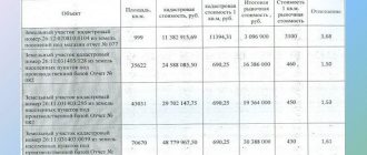
These extract data contain an expanded information base, and each section of the document indicates clear indicators (examples in the photo).
№1
Provides basic land parcel identification or technical specifications. These include:
- Current and previous number of the cadastre and cadastral quarter;
- Description of location;
- Land category;
- Permitted use;
- Square;
- Cadastral value;
- Information about the rights of current and previous copyright holders;
- Purpose.
№2
Contains information about registered rights . This application provides the full name of the copyright holder(s), type of ownership and document details confirming this fact.
Possible encumbrances are indicated in the current form.
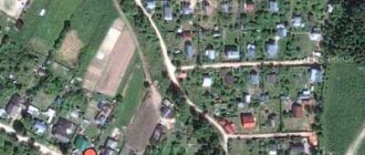
№3
Corresponds to the description of the location of the land plot, including cadastral number and plan.
No. 4 and No. 5
It has a description of the location of the property, including a schematic image of the property, a plan for the location of the premises and a cadastral number.
The authenticity of each sheet is confirmed by a signature, transcript of the signature and the seal of the authorized body.
How to receive and apply?
There are several ways to obtain a cadastral passport for a land plot.
The first method is traditional and involves independently collecting the necessary documents.
To do this, you first need to pay the state fee, then collect documents (this must be a civilian’s passport and a title document for the relevant land property), come to the cadastral chamber unit at the place of registration, take a coupon with the queue number, when it arrives - order the required number of copies documents that you can pick up yourself from the place of issue or receive by mail .
The minimum preparation period (if all the documents necessary for the cadastral passport are available) is 5 working days , the maximum is 20 working days (taking into account the additional preparation of the necessary documentation).
Before applying for a cadastral passport, it is recommended to first make sure for yourself whether all the necessary documents are in the hands of the owner.
List of documents and certificates that are needed to obtain a cadastral passport:
- Owner's passport;
- Document confirming ownership;
- A copy of the title document;
- Cadastral number assigned to the land plot (it is not necessary, but its presence can significantly speed up the preparation of a cadastral passport of land ownership);
- Making changes to the cadastral passport.
The second way to obtain a cadastral passport of a land plot is to order documents via the Internet (online) .
The rapid development of information technology has fully affected the sphere of public administration, making it possible to significantly simplify numerous procedures for obtaining documents and filing necessary requests.
So, issuing any cadastral passport through electronic services no longer seems like something fantastic, but, on the contrary, allows you to save your precious time, avoid long queues and bureaucratic delays.
To do this, you need to send all the necessary documentation (the list is the same as for a personal order) by email, the response and the finished passport will be ready in the same time frame as when ordering at the place of registration.
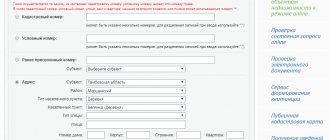
Using the capabilities of the government services portal.
First of all, you will need to prepare all the documents , an exhaustive list of which is presented in detail on the portal .
This includes:
- Application in the prescribed form;
- Applicant's passport details;
- If the application is submitted through a representative, a power of attorney in his name;
- A document assigning ownership of the plot to you or the person whose interests you represent;
- Receipt of payment of the appropriate amount of duty.
If you are not yet registered on the government services portal, you will need to go through a simple registration procedure. If you are already registered, you need to log in to the portal and enter your personal account.
Next, from the list of government bodies, you select the Federal Service for State Registration , Cadastre and Cartography. To begin filling out the application, you must select the “Obtaining information included in the state real estate cadastre” tab.
A standard form will open on the screen, in the appropriate fields of which you must enter all the necessary information . After this, the system will check the information and send your application to Rosreestr, which will make the final decision on issuing or refusing to provide you with a cadastral passport.
You can monitor all stages of your application through the authorities in your personal account, for which there is a special section “My Applications”.
Through the services of the Rosreestr portal.
For some time now, the official Internet portal of Rosreestr has also made it possible to submit an application for the required passport.
Registration on this online resource, as well as digital signatures, will not be required . All you need is free access to the Internet and 20-30 minutes of free time.
The simple and intuitive interface of the site will make it easy to understand the application procedure even for a person who is very far from computer technology.
Find the “Electronic Services” section and select the “Submit a request for State Tax Committee information” tab. After this, the system will prompt you to select the type of document requested and the type of object.
Here you will need to indicate either its actual address or the exact cadastral number.
The last step is to select the desired method of receiving the document:
- paper version of the document. Issued by the relevant department of Rosreestr;
- providing a link to the electronic version of the passport;
- sending the document by mail to the address specified by the applicant.
After filling in all significant fields, you will be asked to enter a security verification code and proceed to the stage of filling out the required information about the applicant. Here you will indicate your passport details, full name and consent to the processing of the provided personal data.
After this, a notification is sent to your email , which will contain the information necessary to pay the state duty . You can make payment using QIWI payment terminals or using any bank card.
After 5 working days after confirmation of payment, you will be able to receive the document you ordered .
Is it possible to receive a refusal of registration?
According to the norms of current legislation, you may be denied the provision of such a public service only in two cases :
- If data about the desired object is not available in the state cadastre databases;
- If it turns out that the provision of information about the object specified in the application is limited in accordance with the provisions of federal legislation.
By the way, the decision to refuse to issue a cadastral passport will also be sent to you within a period not exceeding 5 working days after submitting the application.
Registration cost
The amount of the state fee for issuing any cadastral passport is the same for all applicants and is 200 rubles in the case of an individual and 600 rubles for organizations.
An individual who wishes to receive the service electronically must pay 150 rubles , a legal entity - 300 rubles .
Nuances when filling out a land document form
Each item on the certificate contains basic information about the allotment.
Filling out sections of the document complies with legal requirements:
- The cadastral number is written after adding a colon, while when filling out old forms a hyphen was used.
- If all the data does not fit on one sheet, numbering is used.
- Indicating the total number of pages of the document is a mandatory requirement.
- The recording of the date of registration of the site with the state is strictly checked.
- A note about previous cadastral numbers must be included in this paper.
- Full verification of the accuracy of the entered data at the location of the object.
- Particular attention is paid to the category of the site and permitted use.
- Surveyors rely on a point with a coordinate system.
- Individual paragraphs disclose information about land surveying, division, merger, creation and liquidation.
In addition, the passport is filled out in a certain order and adheres to the established rules.
The information provided to the state real estate cadastre is identically displayed in the cadastral passport, without any corrections, erasures or errors.
The presence of these deviations gives the right to consider the document invalid .
Based on the results of the owner’s request, the finished version is issued on paper, with fixed data on modern printing technology.
You can obtain a land cadastral passport at the territorial office of Rosreestr, at the MFC (provided that the request was generated in the center) or on a PC via email.
Each section is important and cannot be excluded from the document . All data is necessary when making transactions with the site.
What is
This document confirms the owner's right to own the land. If for some reason it is missing from the documentation, then this gap must be filled without fail. Otherwise, no manipulations with real estate will be possible. It is necessary when drawing up a purchase and sale agreement, for transferring land by inheritance, when planning construction work, when leasing and taking out insurance. The form is an extract from the Unified State Register of Real Estate and includes all important information about land ownership:
- exact address, unique cadastral number and cost, total area, type of permitted use, survey boundaries and date of entering the number in the State Cadastre;
- diagram;
- information about the encumbrance, if any;
- a description of the land holding, taking into account all its boundaries, with an exact indication of the size and angles.
Validity
Legislative acts do not specify the validity period of a passport . The reason for obtaining a new document may be construction work carried out to expand or reduce the boundaries of the property.
Data on objects is updated every five years, and if adjustments are made to the plots, it is necessary to notify the BTI about the planned work, and then apply for a new passport.
The state seeks to reduce the time it takes for the population to obtain the necessary certificates, so the system for obtaining data online will be improved.
Procedure and methods of obtaining
Methods for applying for a document:
- in the form of an application submitted in paper form, by personal application;
- in the form of an application submitted in person in paper form, by sending by mail;
- in the form of an electronic form in XML document format sent by email.
Required documents:
- statement;
- certificate of land title (copy);
- applicant's identity card (copy);
- cadastral number (if the plot is already registered).
You will receive the paper within a month.
Cost and terms of receipt
Information entered into the state register, with the exception of cadastral certificates and cadastral plans of territories, is provided within five days, excluding weekends and holidays, from the moment the cadastral registration authority receives the corresponding request (Clause 8 of Article 14 of Law of the Russian Federation No. 221 dated 24. 07. 2007 “On the state cadastre...”).
Based on the provisions of the Law on the Cadastre of the Russian Federation, paragraph 11 of Art. 14 from January 2013, a cadastral passport for any property became paid.
Cost (state fee) for receiving electronically:
- for individuals for 1 copy - 150 rubles,
- for legal entities for 1 copy – 300 rubles.
- Payment method – cashless payment.
Cost (state fee) for receipt in original paper form:
- for individuals for 1 copy - 200 rubles,
- for legal entities for 1 copy – 600 rubles.
- Payment method – cash.
In the event that your data is not yet in the state register, accordingly there is no assigned individual cadastral number, you have not performed land surveying services, then you simply need to contact qualified specialists to carry out all this work and subsequently receive the document. The duration of the entire complex of work will be up to six months, the cost will be from 15 thousand for individuals, from 50 thousand rubles for legal entities.
Validity
The validity period of a cadastral passport is not established by law, and therefore is unlimited. The document contains only the date of issue. If there are inscriptions limiting the validity period of the document, then you should know that this is illegal, arbitrary and punishable. A cadastral passport for a plot is provided to the Federal Reserve Service only in such a case if it was never initially provided to this body, that is, one-time during the initial registration (based on Article 33, paragraph 10 of the Federal Law “On State Registration of Rights...”).
What are there
Previously, a cadastral passport was considered the main document of the land owner. It was required when performing transactions with the allotment. The cadastral chamber was in charge of paperwork. Today its functions have been transferred to the Unified State Register of Real Estate. The form contained unique information regarding the plot owned by the citizen. If the paper was missing, it was impossible to issue a loan using land as collateral, or make a donation, purchase or sale. It was required both during legal proceedings and when changing boundaries.
There were several types of cadastral documentation that was provided for land:
- territory plan;
- passport of a plot of land;
- extract about the territory.
Where can I order a cadastral passport?
You can order a cadastral passport using the following options:
- sending a request via stationary mail.
Minuses:- for a long time;
you will have to spend money on a notary, since the papers must be notarized;
- paid mail services.
- Sending a request online via the website https://www.gosuslugi.ru/. Minuses:
- an electronic signature will be required;
you need a computer with internet;
- Copies must be notarized.
- very fast;
- no need to go anywhere, especially convenient if the nearest registry office is not close;
- It is possible to print an unlimited number of copies.
- Contact the nearest territorial office of the registry authority. One drawback is that you need to attend in person.
Pros:- the received documents will not require notarization;
You will have the originals of all papers at your disposal;
- relatively short method.
The only advantage is the proximity of the post office. This is good if the nearest registry office is far away.
Pros:
How to read a document?
The information in the document is divided into 5 sections . Knowing the structure of the content, you can obtain the required information yourself. The first section (B1) contains general information :
- cadastral number;
- location;
- storage area;
- land category;
- permitted use;
- type of law;
- date of issue of the document, and date of registration of the land plot in Rosreestr.
To receive the entered data, you need to go to the appropriate section by selecting the information you are interested in. The information is given in a table; each column contains an information section with information about the site. For example, columns 7 and 14 contain information about the location of the memory:
- location address;
- coordinate system used;
- site boundaries.
Here, in columns 12 and 13, the most commonly used information on the cadastral value of land is given, taking into account the total area of the plot and the unit cost of one square meter in the massif.
Column 18 indicates the registration numbers previously assigned to the site - conditional, old or assigned before its reorganization.
The second section (B2) provides a diagram of the memory configuration in the form of a solid line , reflecting the location of the boundaries in the surrounding context. The plan and its legend correspond to the scale indicated on the plan page. Sections B4 and B5 give the coordinates of the boundary boundaries of the site, and the turning points along which the boundaries were established.
The third section (B3) contains information about encumbrances with a pledge or easement . If there are no encumbrances, this information is not available.
What does a cadastral passport of a land plot look like?
Cadastral passport of a land plot: completed sample.