Article updated: December 21, 2021
Devyatkin Alexander Land lawyer. Experience working with land plots since 2005.
Hello. In this article I will describe how to establish the boundaries of a land plot, which, although it is registered in the cadastral register (how to find out), its boundaries are not recorded in the cadastre. The instructions are suitable for any site - individual housing construction, private plots, country houses, gardens, etc.
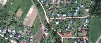
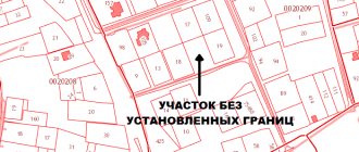
First, find out whether the boundaries of the desired area are on the cadastral map - online. After all, if the site has clear boundaries in cadastral registration, then they do not need to be established, but they can be clarified on the ground.
(click on the pictures to enlarge them)
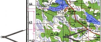
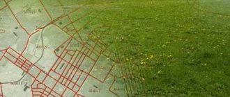
The area is not displayed on the map
Its boundaries are not established
A small digression - if you need a free consultation, write online to the lawyer on the right or call (24 hours a day, 7 days a week): 8 (499) 938-45-78 (Moscow and region); (St. Petersburg and region); (all regions of the Russian Federation).
To establish boundaries, you need to: 1) collect documents for the land; 2) order land surveying and receive a land survey plan; 3) submit an application to the MFC or URFS for state cadastral registration of changes to the property.
We start with stage No. 1 - collecting documents.
Briefly about boundaries, turning points and coordinates
The boundaries of a land plot are determined using geodetic equipment. Each point has its own coordinate, which is calculated by measurements on the ground and subsequent processing of the device data.
Thus, all turning points of a land plot, whether there are 4, 5 or 10 of them, have their own digital designation and are contained in the Unified State Register of Real Estate extract.
In order to quickly find out where the boundaries of the desired area are located by coordinates, you need to order the service: “Placement of boundaries in nature” - this service is provided by geodetic and cadastral companies for a fee.
Let's consider several ways to search for the boundaries of a site by coordinates yourself, using the available data and tools.
Boundary determination procedure
The process of determining the boundaries of a land plot consists of several sequentially performed stages, among which are preparatory actions, geodetic work, drawing up a plan and transferring data on the site to Rosreestr.
Preparatory stage
At the preparatory stage, the owner of the plot must first take care of collecting the necessary documentation .
It will be required to be submitted to the geodetic organization so that the cadastral engineer can begin to determine the coordinates of the site and use the available information to facilitate calculations.
In particular, you will need a document confirming the customer’s ownership , identification, and a certificate of ownership of the site.
If there are erected buildings or structures, you will also need information on them - a technical passport , which contains drawings and dimensions of real estate objects. If available, a cadastral passport of the plot of land is also provided.
After collecting documents and selecting a cadastral organization that will carry out work to establish the coordinates of boundaries, the next step is concluding a contract for the provision of services .
The contract specifies all aspects of the relationship between the parties, as well as their rights and obligations, which, in the event of controversial issues, help resolve the issue peacefully.
After signing the contract, the cadastral engineer authorized to work with a specific site begins processing the documentation and subsequently visits the area to make adjustments if necessary.
Before final approval of the designed boundary plan, the cadastral engineer initiates a general meeting of all interested parties, for which a month before implementation he must notify by any of the methods permitted by law.
Geodetic works
Geodetic work in the process of determining the coordinates of the boundaries of the site is the main stage in the process of drawing up a boundary plan and consists of the following :
- The cadastral engineer goes to the land plot at the appointed time;
- The parameters of the site are measured and the boundaries are drawn;
- Boundary signs are fixed and it is prohibited to change or rearrange them without permission. If they are moved by someone, such an action is defined as a violation of the law, for which they can be held accountable;
- Providing information to all interested parties regarding exactly how the boundaries of the site will be drawn, listening to claims or objections if they are present;
- Placing the signatures of persons on the act of approval of boundaries - such a document is necessary to give legitimacy to the drawn up boundary plan.
Transfer of data to Rosreestr
After the coordinates of the boundaries of the site have been determined and the consent of all interested parties has been obtained, information regarding land surveying must be transferred to the authority for registering data on plots - Rosreestr.
This procedure is carried out by a cadastral engineer at the final stage of work to establish the coordinates of boundaries and does not require additional outside control.
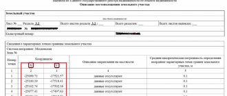
Coordinates from the USRN extract x and y
If you order an extended EGRN extract for a land plot, then in section 3.2 of the extract we will see information about the characteristic points of the boundaries of the land plot in the form of a set of numbers.
The coordinates in the Unified State Register are contained in the local system (in our example, the coordinate system is Moscow).
Is it possible to find the boundaries of the site yourself, knowing these coordinates and how to do it?
Independent search
Since the services of a cadastral engineer must be paid for, many land owners are wondering about the possibility of independently determining the coordinates of the boundaries. Any land owner who wants to carry out a similar procedure and has knowledge in the field of cadastre and cartography is able to determine the boundary independently.
The important point is that the boundaries of the site are accordingly entered into the boundary plan, which will have legal force only if it is drawn up by a cadastral engineer licensed for this type of activity .
Thus, the owner of the plot will not even be able to apply the independently determined boundaries in any way, except to compare their accuracy with those established by the cadastral engineer.
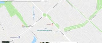
How to find a site by xy coordinates on a map
If you have data from a local coordinate system, then most likely you received it from an extract, which means you have a cadastral number for the land plot. Using the cadastral number, it is easy to determine where exactly the plot is located - you just need to enter it into the search engine of the public cadastral map and you will see not only the location of the land plot, but also its description (address, category of land, cadastral value, area, etc.)
But, if you only have coordinates, then the situation is more complicated.
To find a site using X, Y coordinates, they should be converted to geographic coordinates. To do this, there are a lot of free and paid services for converting coordinates from one system to another on the Internet.
However, keep in mind that the recalculation (especially the free one) will be approximate and the data of such coordinates may have a range of plus or minus a couple of meters, or even more.
If you have the cadastral number of the plot, then you can find its geographical coordinates on the same public page - we wrote detailed instructions on how to do this in a separate article.
In short, move the cursor over the corner of the land plot of interest and click the mouse - the search engine will display the geographical coordinates. See photo below.
How to resolve the error
An appeal to correct the error must be preceded by a lot of work to study the real and nominal boundaries of adjacent land plots with the involvement of competent lawyers and cadastral engineers who would help find the optimal and least expensive algorithm for solving the problem.
Thus, a shift in the coordinate system of the boundaries of one land plot may lead to its overlap with the boundaries of an adjacent one, as a result of which the coordinates of the latter will also have to be clarified, and so on. That is, the initiative of one land user often affects the interests of all neighbors and problems grow like a snowball. Thus, as a result of recalculation of coordinates in the Novosibirsk region, a citizen’s land plot turned out to be located within the boundaries of different municipalities, which is unacceptable in accordance with paragraph 2 of Article 83 of the Land Code. This problem created obstacles for the local government in exercising its powers to establish the boundaries of the settlement. To get out of the situation, it was necessary to obtain the consent of the owner to correct the registry error, and subsequently to divide the land plot owned by him into two new ones with their boundaries located on the territory of different municipalities, to which the owner objected. The division was achieved only on the basis of a court decision.
Obviously, the work of making changes to information about the coordinates of several adjacent land plots is lengthy and costly: in addition to the cadastral work already carried out by the applicant, a forensic land survey, legal assistance, payment of state fees, and so on may be required. The question arises, who bears these costs?
How to determine the coordinates of a plot of land using a smartphone
We have all been using GPS navigation for a long time. However, it is worth understanding that telephones operate on a simplified system and do not always reflect the area as it really is. Surely you have encountered at least once the fact that the navigator periodically “goes stupid” and gets lost on the road. The same thing happens when you try to find the desired coordinate on the ground.
In phones, cell towers are usually used to improve accuracy; in fact, this leads to an error of several meters. Of course, if the plot measures tens of hectares, then this deviation is negligible, but if you want to know the area or boundaries of a plot of 5-6 acres, then the difference in fact will be colossal.
If you still decide to use your phone and use it to determine the coordinates, then use a navigation program - save or write down the geographic coordinates of each point on the ground, and then using these coordinates, find the location of the site on the public cadastral map and make sure whether the actual boundaries coincide with borders of the map.
What it is?
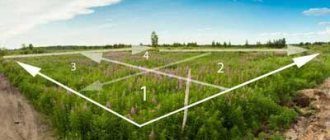
Each plot of land has its own characteristic configuration , and it is not always a clear rectangle with four lines and an angle between them of 90 degrees, as many who are not closely familiar with geodesy and cartography believe.
Even the forming lines themselves, which determine the shape of the site, may not be 4, as is commonly believed, but much more.
At the end of any of the lines forming the boundary, another begins and between them there is a point, which is characterized as a turning (characteristic) point of the land plot.
By imagining a boundary plan or looking at an example of it, anyone can easily determine the location of such turning points between the drawn lines.
Actually, the construction of site boundaries is primarily based on such established points - first, such turning points are determined using various methods, and then the boundaries are designated by simply drawing straight lines between the characteristic designations.
Accuracy and error
Possible errors during land surveying depend on the category of land area and its purpose.
Forest plots, for example, may contain greater error than summer cottages, the boundaries of which must be more accurately determined. Exact requirements for land surveying are reflected in legislation, instructions and documents. According to such documents as “Letter of the Ministry of Economic Development No. 582 dated December 31, 2009.” Errors in land surveying are distributed as follows:
- land plots located within populated areas - from 5 to 10 cm;
- land for agricultural purposes (personal subsidiary plot, individual housing construction, summer house, vegetable garden, garden, garage) - up to 20 cm;
- land plots of the defense industry, special purposes, other industrial purposes, those on which transport lines are located, on which energy facilities are located - up to 50 cm;
- land for agricultural purposes (not including the previously mentioned, more massive areas in the calculation) - up to 2.5 m;
- territories included in the forest reserve, water fund, as well as lands withdrawn from circulation - up to 5 m.
If the standards are not met and the error turns out to be larger, the resulting cadastral error requires correction.