Signature on the fence
It is hardly possible to find a district court in the vastness of the country that would not consider the claims of neighbors who did not divide the hundred square meters. Some people are dissatisfied that a neighbor has taken literally centimeters of someone else’s land, while others have to be indignant at the neighbor’s fence being moved meters deep into their own territory. In any case, almost none of the parties to such a dispute is able to come to an amicable agreement and citizens go to the courts. But even there they do not always find the right articles to resolve land conflicts. Therefore, the determination of the Judicial Collegium for Civil Cases of the Supreme Court of the Russian Federation, which reviewed such a dispute, may be very useful to citizens who find themselves in a similar situation.
So, one citizen filed a lawsuit against his neighbor in his summer cottage. He was outraged that the “invader” moved his fence deeper into his property, seizing 4.8 meters of his territory. The plaintiff also asked the court to oblige the neighbor to dismantle his fence and move it back.
The district court, considering this dispute, proceeded from the fact that the plaintiff and defendant are the owners of neighboring plots of land, and the boundary between their plots was determined by the conclusion of a cadastral engineer.
So there are no violations.
The court also refused to oblige the neighbor to dismantle and move the fence, because this fence is located correctly - on the border indicated by the cadastral engineer. The appeal fully agreed with the decision of colleagues from the district court. So the case reached the Supreme Court. There they studied the verdict of the local courts and said that the decision was incorrect - the norms of the law were violated. These are the rules of law, as explained by the Supreme Court, that should be applied in such disputes.
According to the cadastral law, an interested person does not have the right to raise objections regarding the boundaries of a neighbor’s plot, if these are not common boundaries
There is a Federal Law “On the State Real Estate Cadastre” (N 221 of July 24, 2007). This law states that the “location” of the boundaries of land plots must be agreed upon with the so-called interested parties. This is done in cases where “as a result of cadastral work, the location of the boundaries of a land plot is clarified or the boundaries of adjacent plots, information about which is included in the state real estate cadastre, are clarified.”
The Supreme Court emphasizes that the subject of approval under the cadastre law is the determination of the boundaries of one plot, which are also the boundaries of neighboring acres and belong to someone whom the law calls an interested party. At the same time, the Supreme Court reminds, according to the same cadastral law, this interested person does not have the right to express his objections to the boundaries of his neighbor’s plot, if these are not their common boundaries.
Article 39 of the Cadastre Law states that the approval of boundaries is carried out with citizens who own adjacent plots of land. There are exceptions to this rule - they do not require approval of the boundaries of adjacent plots if the acres are in state or municipal ownership and are provided to citizens for lifelong, inheritable possession or permanent (indefinite) use. Land allocated to legal entities that are neither state nor municipal organizations is also not coordinated with neighbors. Also, no approval is required if state or municipal land is provided for indefinite use to a state-owned enterprise.
In our case, the district court established the fact that the dispute was about adjacent plots of the owners. The Law “On the State Cadastre” says that the approval of boundaries at the choice of a cadastral engineer can be carried out by inviting interested citizens to a meeting, or the boundaries can be agreed upon with each individual individually.
The Supreme Court reminded that the places where the boundaries will be drawn are usually agreed upon at a meeting of interested citizens, if we are talking about the territory of a settlement and its borders. But in this case, boundaries are not drawn within the village or town itself.
In our situation, the land survey was carried out by a cadastral engineer, and the customer for the work was one of the neighbors. They both knew very well that there was another one - an adjacent owner. But they did not agree on the border with him. And one more important point - the cadastral engineer established the customer’s border along the actual border, that is, he drew the land where the neighbor’s fence already stood. The Supreme Court emphasized that the cadastral engineer, having drawn the boundary between the plots along the fence, that is, according to the actual land use, could not help but know that this boundary did not coincide with the boundary in the documents.
From this, the Supreme Court concludes that the lack of agreement on the boundaries of the site may indicate the invalidity of the land survey. And he adds that in such disputes about the establishment of boundaries, the local court has the right to evaluate the actions of the cadastral engineer, even without a request from one of the parties. The demands made by the neighbor against the invader fall under Article 60 of the Land Code.
This article of the Land Code talks about such a way to protect one’s interests as restoring the situation that existed before a citizen’s rights to a land plot were violated.
As a result, the Supreme Court overturned all decisions and ordered the case to be reconsidered, but taking into account its clarifications.
By the way
A lawsuit over land could end in big problems. Thus, in Lipetsk, a dispute between neighbors over seized acres resulted in a criminal case against the plaintiff’s son, since the deputy chairman of the regional court was a party to this dispute. The matter turned out to be extremely scandalous. After the indignation of the country's president, he is now being dealt with by the Prosecutor General's Office.
The procedure for establishing actual boundaries
Occurs in several stages:
- Stage 1. An agreement is concluded with a special geodetic, licensed company.
- Stage 2. Land surveying is being carried out.
- Stage 3. A boundary plan is drawn up.
- Stage 4. The information received is sent and entered into the state real estate cadastre.
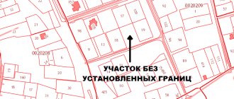
A site without boundary coordinates: what does this mean?
Such a plot is a property that does not have extreme points, so it is impossible to separate it from common or neighboring ones.
It is impossible to sell or rent or build a house on it. This may lead to lawsuits and will not allow you to obtain a cadastral number.
Statute of limitations
For each conflict concerning plots of land, the general provisions regarding the limitation period apply - it is three years. It begins to be calculated from the moment the applicant learns about the occurrence of circumstances when his rights began to be violated.
In judicial practice and consideration of cases concerning land disputes on adjacent plots, it is difficult to determine the exact date of violation of the applicant’s rights. In this case, the time for consideration of the claim is increased only by decision of the judicial authorities.
How to write an appeal to the owner
An appeal may be filed if a party to civil proceedings does not agree with the essence of the decision made by the court or the reasons for its adoption, but is convinced that it is right .
In general, the form of the appeal is in many ways similar to the form of the statement of claim filed in the court of first instance. Thus, its header indicates the name of the court and provides similar information about the party filing the complaint, the other party, third parties and the representative (if any).
Below in the middle of the line is written “Appeal”, then the text itself is located.
The content of the appeal states:
- what decision the court of first instance made;
- grounds confirming the illegality of the decision;
- links to provisions of regulations;
- results of examinations (if they were carried out).
The pleading part of the appeal must contain a request to cancel the previous court decision.
Below is a list of attachments to the appeal . At the end of the document, the date of its preparation and the signature of the person on whose behalf the complaint is being filed (or a representative) are indicated.
A sample appeal can be downloaded from this link.
1 month from the date of the court decision and bringing it to the attention of the participants in the trial to file an appeal
Documents that are the results of land surveying
After the completion of the land surveying procedure, the owner of the plot is given a land survey plan . It shows the boundaries of land ownership, the location of which was clarified by the cadastral engineer after carrying out the necessary procedures.
The boundary plan consists not only of a graphical part, it also includes a text description, which includes information about the site and information about the work carried out by the engineer.
The boundary plan is approved on the basis of a boundary approval act, which must be signed by all persons interested in the results of the survey (primarily neighbors on the site). The act is attached to the text part of the boundary plan.
If someone has objections, they are drawn up in writing and certified by the signature of the person having the claims .
More detailed information about the boundary plan can be obtained from a separate thematic article.
Land management examination
If the evidence base does not fully confirm the validity of the plaintiff’s claims, a land survey examination is appointed. It is usually carried out within the framework of court proceedings, in accordance with the determination of the judge. The definition states:
- the exact location of the land plot in relation to which the dispute arose;
- terms of examination - the time interval during which the procedures are carried out or the date by which the expert submits a conclusion;
- questions answered by the expert during the investigation;
- the cost of services of a specialist in land management expertise.
Liability and fines
The listed cases are defined as squatting , violation of the boundaries of a land plot (Article 7.1 of the Code of Administrative Offenses of the Russian Federation) and are subject to sanctions and a fine, the amount of which determines the status of the violator:
- for individuals – from 5 to 10 thousand rubles;
- for legal entities – from 100 to 200 thousand.
The court has the right to impose a penalty based on the cadastral value of the illegally used plot or part thereof. In this case the penalty is:
- for individuals : 1-1.5% of the cadastral value of the occupied land plot;
- for legal entities : 2-3% of the same amount.
A fixed fine is imposed if the cadastral value of the land plot is not established.
After payment of the fine, the responsibility for conscientious observance of boundaries remains in force. Land surveying will help resolve such controversial issues (you can find out what it is here).
Causes of disputes
Disputes related to the results of surveying may arise due to the fact that :
- the cadastral engineer made mistakes;
- there are other problems on the part of the cadastral service (for example, loss of a license);
- one of the land owners (or both) made attempts to unauthorizedly increase the area of their territory at the expense of the adjacent plot;
- Due to the demarcation of the neighboring area, a situation arose with the overlapping boundaries of adjacent lands.
Disagreements regarding the location of boundaries may arise for other reasons. They are discussed in detail in the article, which can be read by following the link.