Home / Real estate / Land plot / Land survey / Cadastral passport / Cadastral plan / Boundary plan
Back
Published: March 22, 2017
Reading time: 10 min
0
614
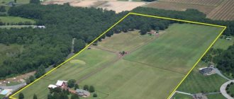
Land surveying is an important event that allows you to resolve land management issues, both nationwide and in private disputes between owners of neighboring land plots.
The results of land surveying carried out by a cadastral engineer (CI) are displayed in a special document - a land survey plan (MP). Registration of MP must be carried out in accordance with regulatory documents.
- Legislation
- MP form
- General requirements for MP preparation
- Requirements for preparing MP when clarifying boundaries
- Requirements for preparing MPs during redistribution
Legislation
The definition of MP is given in Law No. 218-FZ “On Real Estate Registration”.
In accordance with it, the MP is formed on the basis of data on the memory from the Unified State Register and other information about the formed or already existing memory and their parts. That is, the MP must indicate:
- information about newly formed storage facilities and parts of storage facilities;
- new information about the memory or parts thereof, which must be entered into the Unified State Register of Real Estate;
- information about changed areas.
Appendix 1 to Order of the Ministry of Economic Development No. 921-FZ provides the form and composition of information, and Appendix 2 contains the basic requirements for the preparation and execution of MP. This order came into effect at the beginning of this year.
This order contains references to some provisions of Law No. 221 - Federal Law. For example, a link to Art. 40, related to the preparation of the Act on the approval of the boundaries of the land plot.
MP form
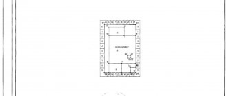
In form, the MP consists of a text part in the form of tables and a graphic part, including drawings and diagrams.
These parts have several sections. At the same time, there are sections that must be present in any MP, and sections, the presence of which depends on the type of cadastral work being carried out.
The text part of the MP may include sections:
- general information;
- source data;
- information about measuring work and calculations;
- information about newly formed, amended and updated memory and their parts;
- information on providing access to created and modified memories; clinical trial conclusion;
- act of approval of the boundaries of the land plot.
The graphic part may contain diagrams of geodetic constructions and the location of the site, as well as a drawing of the site and outlines of the nodal points of the land plot.
In this case, any MP must contain the first three sections of the text part, as well as a diagram of the location of the memory and its drawing.
The MP for the memory obtained by combining must include sections:
- general information;
- background information;
- information about the formed memory;
- information about access to storage;
- memory drawing.
The section describing the scheme of geodetic constructions is not included in the MP if these constructions are made using a cartographic or analytical method.
All entries in MP are made in Russian and using Arabic numerals.
By order of the Ministry of Economic Development of the Russian Federation dated December 8, 2015. No. 921 “On approval of the form and composition of information on the boundary plan, requirements for its preparation” defines the form of the boundary plan in the form of a table and establishes the rules for drawing up the document.
A boundary plan is a document that is drawn up on the basis of a cadastral plan of the relevant territory or an extract from the Unified State Register of Real Estate about the corresponding land plot and in which certain information entered in the Unified State Register of Real Estate is reproduced and information about the land plot or land plots being formed is indicated, or about a part or parts of a land plot, or new information about a land plot or land plots necessary for entering into the Unified State Register of Real Estate.
The boundary plan indicates:
1) information about the land plot or land plots being formed in the case of cadastral work, which results in the preparation of documents for submission to the rights registration authority of an application for state cadastral registration of the land plot or land plots;
2) information about a part or parts of a land plot in the case of cadastral work, which results in the preparation of documents for submission to the registration authority of rights of an application for state cadastral registration of a part or parts of a land plot;
3) new information about a land plot or land plots necessary for entering into the Unified State Register of Real Estate in the case of cadastral work, which results in the preparation of documents for submission to the rights registration authority of an application for state cadastral registration of a land plot or land plots.
If, in accordance with federal law, the location of the boundaries of land plots is subject to mandatory approval, the boundary plan must contain information about such approval.
The boundary plan consists of graphic and text parts.
The graphic part of the boundary plan reproduces information from the cadastral plan of the corresponding territory or an extract from the Unified State Register of Real Estate about the corresponding land plot, and also indicates the location of the boundaries of the land plot or land plots being formed, or the boundaries of a part or parts of the land plot, or the specified boundaries of land plots, access to newly formed or modified land plots (passage or passage from public land plots), including through the establishment of an easement.
The text part of the boundary plan indicates the information about the land plot or land plots necessary for entering into the Unified State Register of Real Estate, including information about the geodetic basis used in preparing the boundary plan, including points of state geodetic networks or reference boundary networks, as well as information about coordination of the location of the boundaries of land plots in the form of an act of approval of the location of such boundaries.
The location of the boundaries of the land plot is established by determining the coordinates of the characteristic points of such boundaries, that is, the points of change in the description of the boundaries of the land plot and dividing them into parts.
The area of a land plot, determined taking into account the requirements established in accordance with this Federal Law, is the area of a geometric figure formed by the projection of the boundaries of the land plot onto a horizontal plane.
When clarifying the boundaries of a land plot, their location is determined based on the information contained in the document confirming the right to the land plot, or in the absence of such a document, based on the information contained in the documents that determined the location of the boundaries of the land plot when it was formed. If there is no information in the documents about the location of the boundaries of the land plot, their location is determined in accordance with the territory surveying project approved in the manner established by the legislation on urban planning activities. If there is no information about such a land plot in the approved land surveying project, its boundaries are the boundaries that have existed on the ground for fifteen years or more and are fixed using natural objects or objects of artificial origin that make it possible to determine the location of the boundaries of the land plot.
The boundaries of a land plot should not cross the boundaries of a municipal entity, except if an error reproduced in the Unified State Register of Real Estate is identified in determining the location of the boundaries of such a municipal entity in the document on the basis of which information was entered into the Unified State Register of Real Estate. The boundaries of the land plot should also not cross the boundaries of a populated area, except if an error reproduced in the Unified State Register of Real Estate is identified in determining the location of the boundaries of such a populated area in the document on the basis of which information was entered into the Unified State Register of Real Estate. The boundaries of the land plot should also not cross the boundaries of territorial zones, forest districts, forest parks, with the exception of the case of the formation of a land plot for geological exploration of subsoil, development of mineral deposits, placement of linear objects, hydraulic structures, as well as placement of reservoirs and other artificial water bodies or a case of detection of an error reproduced in the Unified State Register of Real Estate in determining the location of the boundaries of the territorial zone. At the same time, the intersection of the boundaries of a land plot with the boundaries of municipalities, settlements, territorial zones, forest districts, forest parks means:
1) the presence of a common point or points of the boundaries of the land plot and the boundaries of the municipality, settlement, territorial zone, forestry, forest park, which are formed as a result of the location of one or more characteristic points of the boundaries of the land plot outside the range of the mean square error in determining the characteristic points of the boundaries of the municipality , settlement, territorial zone, forestry, forest park;
2) the location of at least one of the contours of the boundaries of a multi-contour land plot outside the boundaries of the corresponding municipality and (or) settlement or territorial zone.
The boundary plan is prepared in the form of an electronic document and signed with an enhanced qualified electronic signature of the cadastral engineer who prepared such a plan. The boundary plan, if provided for in the contract, is also prepared in the form of a paper document, certified by the signature and seal of the cadastral engineer who prepared such a plan, for transfer to the customer under the contract.
The form and composition of information on the boundary plan, requirements for its preparation, as well as requirements for accuracy and methods for determining the coordinates of characteristic points of the boundaries of a land plot are established by the regulatory authority.
General requirements for MP preparation
Requirements for the preparation of MP are the rules for its execution (Order of the Ministry of Economic Development No. 921-FZ).
The MP is issued in electronic form (XML document). The electronic version of the MP must correspond to its paper version on a scale of 1:1. It is certified by the enhanced electronic signature of its executor - CI.
In this case, the means for obtaining an electronic signature must have an appropriate certificate.
The MP is considered to be put into effect 2 months after it was posted on the official website of Rosreestr (https://www.rosreestr.ru).
Sections of the graphic part, the Certificate of Approval, as well as additional documents are executed in PDF format. Documents must be scanned with a resolution of at least 300 dbi. These documents are certified by the electronic signature of the CI.
If the Appendix to the MP includes a document issued by authorities, then its electronic copy must be certified by the electronic signature of a representative of the authorities.
If necessary, MP can be performed on paper. In this case, the paper version of the MP and the Certificate of Approval must have the signature and seal of the performer.
When developing MP, information about land plots located in the Unified State Register of Real Estate is used and, in addition, data from the cartographic and geodetic fund or other funds containing land management information can be used. For example, approved projects of gardening or dacha associations.
Various documents confirming the rights to the land plot can also be used. For example, decisions of government authorities to provide a citizen with a loan.
The developed law must reflect court decisions that have entered into force on this law.
ATTENTION! Recommendations for drawing up the geodetic part of the boundary and technical plan.
1) The scheme of geodetic constructions is included in the boundary or technical plan in the case of using the geodetic method, the method of satellite geodetic measurements. The geodetic construction scheme is not included in the boundary or technical plan in the case of using an analytical or cartometric method for determining coordinates. The geodetic construction diagram is not included in the boundary or technical plan in the case of using the photogrammetric method. When applying the photogrammetric method, the conclusion of the cadastral engineer indicates that the geodetic construction scheme is not included in the boundary plan, since measurements were not required to determine the coordinates of the characteristic points of the boundaries of the land plot, which is provided for by the requirements of paragraph 14 of Order No. 921 of the Ministry of Economic Development "On approval of the form and composition of information on the boundary plan, requirements for its preparation.”
2) We recommend that outlines of the nodal points of the boundaries of land plots be included in the boundary plan in order to describe the location of the boundaries, regardless of the geodetic basis used and the results of the measurements taken. It is recommended to draw up outlines of nodal points in the presence of interested parties when agreeing on the boundaries of land plots. The inclusion of outlines in the boundary plan allows one to avoid accusations from land owners that the location of the boundaries was not clearly indicated to them. The presence of Outlines allows you to restore the boundaries of a land plot on the ground without using coordinates. The following can serve as long-term and clearly identifiable terrain objects: corners of building foundations, power line supports, underground utility hatches, transformer booths, fixed drain grates, corners of permanent fences.
3) When using a cartographic basis obtained from the state cartographic and geodetic fund or the state fund of land management documentation to prepare a boundary plan, the details of the received document and other information provided for by the order are indicated in the boundary plan. When using cartographic material obtained from other sources, the name of the organization that produced the material, the inventory number, number or nomenclature, and the date of its creation are indicated. If there is no information about updating the cartographic material, indicate “not updated”. The cartographic materials themselves are not included in the annexes; fragments of these materials are used in the boundary plan. It is recommended to combine the specified or defined boundaries of land plots on one drawing with the used cartographic materials in the Layout Scheme or Drawing.
4) The boundary or technical plan must include information on the name and details of the document on the provision of data from the cartographic and geodetic fund or land management documentation fund on the coordinates of points of the state geodetic network or reference boundary network. The received documents with coordinates themselves are not included in the appendices of boundary or technical plans. It is allowed to include in the appendices of the boundary or technical plan an extract from the received catalog of coordinates, certified by the signatures of two persons - the one who compiled the extract and the one who certified the extract.
5) Particular attention should be paid to the indication in the information of the boundary or technical plan of current information about the condition of the points used. If Rosreestr has information that a geodetic point has been lost (obtained from boundary or technical plans drawn up by other cadastral engineers and from materials of its own surveys, and the cadastral engineer indicates that the point has been preserved, then information about such facts can be transferred to Rosreestr to the authorities Prosecutor's office to initiate a case on the inclusion of knowingly false information in the boundary or technical plan.The boundary or technical plan should indicate information about at least three points of the state geodetic network or reference boundary network that have been surveyed and preserved.
6) In boundary or technical terms, indicate information about the approval of the type of measuring instruments, which are taken from the official website of Rosstandart fundmetrology.ru. The name of the measuring instrument should be exactly copied from the official website in order to avoid questions from Rosreestr. In addition to the name of the device, indicate the number of the means of change in the State Register and the period of the certificate. Devices produced during the period of validity of the type hardening certificate can be used after the expiration of its validity period without restrictions, subject to periodic verification.
7) The Geodetic Construction Scheme reflects a schematic image of the cadastral work object, the location of the points of the geodetic basis used, the location of survey justification points (when using the geodetic method of determining coordinates), the location of the base station that provides RTK corrections or is used for joint processing of measurements (when working with satellite receiver in RTK, fast static, kinematic modes). It should be noted that the coordinates of permanently used, fixed base stations must be determined from the geodetic points used. To resolve possible disputes, it is strongly recommended to draw up and store a report on the engineering and geodetic surveys to determine the coordinates of the base station. In addition, to perform geodetic work with satellite measurements, you can use permanently assigned base stations, for which a report on the creation of a special-purpose network and the coordinates of which have been transferred to the federal spatial data fund. In the case of using such stations, there is no need to provide information about the geodetic points used in the survey or technical plan, but details of documents confirming the compliance of the base station used with the established requirements should be provided.
Cadastral engineers are recommended to prepare and store reports on engineering surveys when performing cadastral work. Such reports allow you to prove the correctness of the measurements taken and resolve controversial situations. Cadastral engineers who do not carry out surveying work themselves are advised to obtain similar reports from the surveyors who carried out the work. The report must be signed by the contractor. From such a report for a boundary or technical plan, information is taken about the geodetic basis used and its condition, a diagram of geodetic constructions, and information about the instruments used.
9) The requirement that the boundary or technical plan “must contain information about at least three points of the state geodetic network or reference boundary network” should be understood as follows. It is necessary to perform one-time measurements at points of the geodetic network, the coordinates of which are obtained from official sources, and create a survey justification that will be used repeatedly. The measurement results must be processed using accessible methods and the discrepancy value in coordinate values must be obtained, which must be within acceptable limits. To determine the coordinates of a land plot or the contour of a building, the adjusted value of the coordinates of the original geodetic points should be used. It is recommended to document the results of measurements performed on the original geodetic surveys in a technical report on the production of engineering and geodetic surveys. The report data allows you to have an evidence base when resolving conflict situations and respond to unfounded claims of incorrect determination of coordinates during cadastral work.
10) The diagram of geodetic constructions should show, among other things, how the coordinates of the original geodetic points were adjusted by displaying the directions of the corresponding measurements on the diagram. Examples of geodetic construction schemes are attached. Also attached are examples of Schemes that should not be used as examples.
Examples of drawing up Schemes of geodetic constructions:
Examples of drawing up Schemes that should NOT be used
Requirements for preparing MP when clarifying boundaries
When preparing a MP for work to clarify the boundaries of the land plot, the following should be additionally included in the MP:
- documents related to compliance with the procedure for notifying the necessary persons about a meeting to agree on the boundaries of the land plot. This clause of the law concerns the case when interested parties did not sign the Agreement and did not submit their objections regarding these boundaries in writing. In this case, the MP must be accompanied by documents confirming that the notification of neighbors in the land plot took place in accordance with the procedure specified in the law;
- copies of powers of attorney certified by a notary for representatives of owners of adjacent land plots;
- if there are objections regarding the boundaries of the land plot, written objections from neighbors or their proxies;
- if there is a land dispute, documents indicating the resolution of such a dispute.
In the absence of agreement on disputes regarding the boundaries of the land plot, the MP is transferred to the customer for work to coordinate the boundaries of the land plot.
In this case, the MP, carried out during cadastral work (K-+R) to clarify the boundaries of the land plot, must contain information:
- about the existing and refined coordinates of characteristic points and the mean square errors of the location of these points (Mt);
- about parts of the boundary of the land plot from one characteristic point to another;
- about the size of the storage area obtained as a result of calculations using measured coordinates (P), and the accuracy of determining this area (ΔP);
- on the size of the storage area indicated in the Unified State Register of Real Estate (RKAD);
- about the discrepancy between the calculated and indicated in the Unified State Register of Land Use areas (R-Rcad).
The MP must contain information about the parts of the memory (if any).
In addition, the MP must contain data on adjacent memory units.
If the plot is suitable for the landlord, then he will be interested in learning how to register ownership of the land if it is leased. What is an apartment card and where can I get it? Find out about it here.
Are you planning to buy an apartment? You can find out in detail all the information about this type of real estate in our article.