For each land management object, a specific package of documents is formed, called a land management file.
When buying and selling a plot, when seizing land, conducting an inventory, and in a number of other cases, it is important to collect all the documents in order to correctly register the plot with the cadastral register.
What is land management and why is this concept not used in 2021?
Obtaining an archival copy of the land management file
The procedure for storing and providing archival documentation is regulated by Law No. 78-FZ of 2001, Order of the Ministry of Economic Development No. 376 of 2006 and other regulations. If Rosreestr employees violate the established procedure for issuing papers or illegally refuse to provide an archival copy of the land management file, then this violation or refusal can be appealed to a higher order - by sending a complaint to the management of Rosreestr, or in court by filing a corresponding claim in court.
- Information from geodetic and cartographic works.
- Information about soil, geobotanical and other surveys and surveys.
- Land quality assessment data.
- Information about the inventory of sites.
- Thematic maps of lands.
- Atlases of the state and use of lands.
- Land management schemes for municipalities.
- Information on surveying land management objects.
- Maps of land management objects.
- On-farm land management projects.
- Land management files of land surveying data created before January 1, 2009.
Rosreestr organizes methodological support and coordination of the activities of territorial bodies of the department in the constituent entities of the Russian Federation and subordinate organizations for maintaining the state fund of data obtained as a result of land management, and carries out interdepartmental interaction with federal executive authorities authorized to maintain archives and state data funds.
- implementation of a clear and intelligible result in the field of solving various problems of a geodetic nature, as well as correct technical support indicating all turning points and additions in the compiled site plan;
- priority and the opportunity in the future to quickly and efficiently conduct an inventory of all land plots.
A land plot plan is a legal document containing all the information regarding the parameters of a land plot. The land survey plan is produced with one single purpose - to transfer it to the cadastral chamber so that the land can be registered with the state. Registration begins with calling an engineer to the site.
Many citizens do not know what the difference is between land management and boundary plan . In essence, these are two documents that are identical in structure, but the concept of “land management” existed until 2008, and later it was replaced by a boundary plan.
So, a plot of land has been purchased. From a moral point of view, a citizen feels like the master and owner of real estate, but from a legal point of view, the right to ownership also needs to be “secured” in documents, and this is where the turn of land surveying comes.
Answers to questions on the topic
Where can I get a land survey document if I lose it?
Where is the land management file for a land plot kept and is it possible to obtain documentation for an allotment without going through a repeated land surveying procedure and completing all the documentation?
Since land management today means a boundary file (landmark plan), in order to obtain it in case of loss, the owner of the plot should contact Rosreestr or the MFC, pay the state fee and receive a copy of the plan.
Land survey work will not have to be done again only if the boundaries of the site have not been changed. Otherwise, you will have to re-issue the allotment documentation.
What is the difference between land surveying and boundary planning?
Many citizens do not know what the difference is between land management and boundary plan . In essence, these are two documents that are identical in structure, but the concept of “land management” existed until 2008, and later it was replaced by a boundary plan.
But there is one significant difference in these documents - the land management deed could only be signed by the head of the topographic and geodetic company, while the boundary plan can only be endorsed by a cadastral engineer.
Is it necessary to do land surveying if there is a land management business?
Many citizens are interested in: “Is it necessary to carry out land surveying if there is a land management document, but this document is no longer used in 2021?”
If the site has already been registered with the state and no changes have occurred regarding the boundaries, then the land surveying procedure does not need to be done . If the parameters of land ownership have changed, then it is worth ordering a boundary plan of the territory.
What is the validity period of a land survey document?
This document has an indefinite validity period. In the same way, the boundary plan of the site currently has no statute of limitations.
Until 2008, a land management file was registered for each plot of land that became the property of a new owner. This is a set of ordered documents that recorded information about the owner of the plot, data about the land plot, etc.
Based on the land management file, information about the site was entered into the state real estate cadastre . As of 2021, the concept of land management has been abolished. It was replaced by another concept - a boundary plan.
Where is the land survey file kept?
The boundaries specified in the documentation are highlighted on the ground in any available way: with the help of special signs, a fence, and so on. If the territory of the plots overlaps, it is important to obtain approval from the neighbors. If the latter do not want to sign the agreement, you need to contact higher authorities that resolve controversial issues, or the court. Thanks to the boundary plan, you can easily resolve controversial issues with neighbors on the site.
We recommend reading: List of Medicines for Federal Beneficiaries for 2021
1) if there is no information about the land in the Unified State Register of Real Estate, although the owner’s right was formalized according to old laws (before 1998), when a modern registration authority was created. For example, real estate was registered according to the old rules by the BTI authorities (Bureau of Technical Inventory);
- Documentation . You need to find all the paper documents for the site (see above). They should contain the survey results in the form of drawings, the name of the cadastral engineer, and the date of survey.
- At the local branch of Rosreestr . In order to obtain information, you need to go to the office with your passport. To obtain information, you must write an application and, depending on the completeness of the information, pay a state fee.
- You can contact Rosreestr through the MFC (Multifunctional Center).
- You can obtain information online through the official website of Rosreestr. To do this, you need to find the “Individuals” section and select the desired service in “electronic services.” Information can be obtained both in paper form (through the Rosreestr office) and electronically. The second one is preferable, especially when you have little time. Simply fill out the application form and pay for the service. As a rule, a response to the specified email arrives half an hour to an hour after payment.
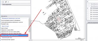
- On the public cadastral map . Basic information can be found here.
- The fact of surveying is entered into the database . At first it was a state cadastre, which is now part of the federal Rosreestr system.
- The land survey could have taken place a long time ago, and the paper documents could have gotten lost. But, if the site is demarcated, data about this can be found and renewed in Rosreestr .
- Information may be incorrect . If you suspect that this is the case, you need to contact the cadastral chamber with paper documents.
- The human factor cannot be excluded when, when transferring information, not all of it was included. Thus, the electronic version of the survey may not have been preserved.
- Brief information about the land plot (including on the issue of land surveying) is available to all citizens of Russia, that is, it is public .
Judicial land management examination
Forensic land management examination is one of the types of forensic examinations and belongs to the list of types (types) of forensic examinations 27.1 “Investigation of land management objects, including the determination of their boundaries on the ground” of Order of the Ministry of Justice of Russia dated December 27, 2012 N 237 (as amended on September 13. 2018). In order to conduct a forensic land management examination, an expert must have a basic expert higher or secondary vocational education or undergo professional retraining and receive an expert diploma with the right to conduct professional activities.
Having a specialized education is the main qualification of an expert to conduct a forensic examination. According to the procedure for conducting and processing the examination, each expert report indicates the education of the expert and files a copy of the diploma.
The Academy of Advanced Training and Professional Retraining provides training for experts in the Forensic Land Management program, taking into account all the requirements for modern experts.
The retraining program for forensic experts contains a module on the study of current land legislation, on the procedure and methods of conducting land management examinations, and also pays special attention to the preparation and execution of expert opinions. Contents Relevance of the program Types of forensic land management examination Regulatory framework of land management examination List of documents for conducting a judicial land management examination The purpose of a judicial land management examination The main stages of a land management examination Appealing a judicial land management examination Curriculum Distance learning format Diploma of professional retraining Obtaining a diploma of professional retraining Tuition fees Discounts for training Publication of scientific works Electronic library
Types of forensic land management examination
Modern Russian civil legislation distinguishes five types of examinations:
- The main examination is carried out, as a rule, by decision of the judicial authorities, but can be carried out without it.
- Additional examination – this examination is carried out in the case when the previously generated expert opinion is unclear or incomplete. An additional examination has the right to be carried out by a new expert or the same one previously appointed (clause 1 of Article 87 of the Code of Civil Procedure of the Russian Federation).
- Re-examination – this re-examination is carried out only if the judge has doubts about the validity or correctness of this expert opinion. Only a new expert or expert group has the right to conduct a repeat study (clause 2 of Article 87 of the Code of Civil Procedure of the Russian Federation).
- Comprehensive examination - this examination contains several types of work that are performed by several experts or expert groups at the same time (clause 1 of Article 82 of the Code of Civil Procedure of the Russian Federation).
- Commission examination – this examination is usually carried out by several forensic experts. A commission examination is carried out if it is necessary to resolve an issue that goes beyond the scope of one area (clause 1 of Article 83 of the Code of Civil Procedure of the Russian Federation).
The professional retraining program for experts contains a section on studying the stages and methods of all types of forensic land management examination. During practical classes, Academy teachers and students jointly conduct an examination of drawing out the boundaries of land plots, an examination of the division of a land plot, an examination for boundary work, an examination of construction geodesy services, and also compile a review of the conclusion of experts on land management examination. Based on the results of the training, each student develops his own portfolio of expert land management examinations of various types.
Regulatory and legal framework for land management expertise
When conducting a forensic land management examination, a forensic expert or expert group must be guided by the following regulations:
- Civil Code of the Russian Federation (Part 3) dated November 26, 2001 No. 146-FZ;
- Land Code of the Russian Federation dated October 25, 2001 No. 136-FZ;
- Arbitration Procedural Code of July 24, 2002 No. 95-FZ;
- Criminal Code of the Russian Federation of June 13, 1996 No. 63-FZ;
- Town Planning Code of the Russian Federation dated December 29, 2004 No. 190-FZ;
- Housing Code of the Russian Federation dated December 29, 2004 No. 188-FZ;
- Order of the Ministry of Economic Development of the Russian Federation No. 412 of November 24, 2008 “On approval of the form of the boundary plan”;
- Federal Law of July 24, 2007 No. 221-FZ “On the State Real Estate Cadastre”;
- Federal Law of July 21, 1997 No. 122-FZ “On state registration of rights to real estate and transactions with it”;
- Federal Law of June 18, 2001 No. 78-FZ “Land Management”;
- “Methodological recommendations for carrying out surveying of land management objects” approved by Roszemkadastr on February 17, 2003.
The professional retraining program for experts contains a module on the study of regulations for conducting forensic land management examinations.
Each act is discussed in detail during lecture classes. Academy teachers help students correctly determine the legislative basis for conducting an examination, based on their type of forensic land management examination.
List of documents for conducting a forensic land management examination
The documentation package for forensic land management examination includes:
- Statement of claim.
- Personal documents of the applicant or personal documents of the legal representative (passport, power of attorney).
- Legal documents. Legal documents include: purchase and sale agreement, certificate, gift agreement, extract from the Unified State Register, will, extract from the cadastral chamber, etc. An extract from the cadastral chamber is the main title document, since registration certificates are currently not issued.
- Cadastral passport of the object.
- Technical plan, with marks of all buildings on a given land plot.
A citizen must prepare this documentation package for conducting a land management examination through the court. And also during the forensic examination, the court or the expert himself has the right to request many other documents that are necessary for the examination.
The purpose of forensic land management examination
Each land management examination is carried out for a specific purpose, which is set before the expert or expert group. Land management examination is carried out for the purpose of:
- Establishing the location of real estate on the land.
- Determination of options for the actual division of the land plot.
- Determining whether there are boundaries on earth.
- Determining the possibility of erecting any construction project on the site under study with already prepared, given parameters.
- Establishing the fact that the property of another owner is located within the boundaries of a land plot owned by one person.
- Determining the correspondence between the actual area of the site and its area according to the title documents.
- Establishing boundaries on a site in accordance with title documents or if there is a court decision with an established land use procedure.
Professional retraining of experts includes the study and training of land management examinations for various purposes. During practical classes, Academy teachers examine each goal in detail and, together with students, draw up an expert opinion, adding to the portfolio.
Main stages of land management examination
The procedure for conducting the examination is fixed in the Decree of the Government of the Russian Federation of April 4, 2002 N 214 “On approval of the Regulations on the state examination of land management documentation.”
Land management examination is carried out in three stages. The first stage is preparatory, at which the coordination of future work takes place: determining the purpose of the examination, composition, deadlines.
The second stage of land management examination is field. At this stage, work is carried out directly on the land plot, measurements are taken, the coordinates of points, the boundaries of the site, the definition of buildings, etc. are determined.
The last stage is desk or office. At the last stage, the expert processes the results obtained during the field stage, prepares documentation, draws up and officially confirms the expert land management assessment and examination.
Appeal against judicial land management examination
After conducting a judicial land management examination in accordance with Art. 86 of the Code of Civil Procedure of the Russian Federation, a forensic expert or a judicial commission draws up a written expert opinion, which must contain a detailed description of the research conducted, the conclusions drawn as a result and answers to the questions posed by the court.
Both the court itself and the participants in the case may disagree with the results of the examination. If the court disagrees with the results of the expert opinion, the court has the right to order a repeat or additional examination. This court decision must be motivated and justified.
If the participants in the case do not agree with the expert opinion, an objection is filed, which is drawn up according to the petition algorithm. You can also appeal the examination by filing an objection to the expert.
Land surveying
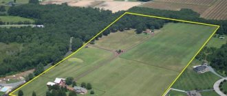
A land survey deed is a document of title that contains all the information about this plot and its boundaries. If there is no land survey, then it will not be possible to register ownership of the land, and accordingly, the owner will not be able to conclude any transactions in relation to this land.
The results obtained are necessarily documented in writing in the prescribed form and as a result, a land surveying file is formed. In no case should it violate the legitimate interests of the owners of adjacent territories, otherwise all the work will have to be done anew by one and the other party.
Land management (land survey) of a land plot; what is it and where to get it
So, a plot of land has been purchased. From a moral point of view, a citizen feels like the master and owner of real estate, but from a legal point of view, the right to ownership also needs to be “secured” in documents, and this is where the turn of land surveying comes.
Since these concepts are directly related to the preparation of papers that are needed to own land and land plots, and are also a mandatory item in all land transactions (construction, purchase and sale, lease). Therefore, it is worth familiarizing yourself with this terminology, understanding the essence, in order to avoid fatal mistakes.
We recommend reading: Allowance for 3 children in 2021 Krasnoyarsk
The legislator adopted an act that directly regulates land management, where the details of measuring and establishing boundaries, indicators and coordinates of the site are indicated. Moreover, there are rules and restrictions in this regard. This law assumes that the area of the territory, which is the main indicator of the site, should not be less than the limits provided for by the regulations. That is, all measurements must be as accurate as possible and contain a minimum error.
When preparing documents to register a land plot, it is necessary to hire private specialists accredited to carry out cadastral work. This condition also applies to government bodies when accounting for plots of public property. Particular attention must be paid to filling out documents. Documents in which corrections or additions are found will be considered invalid, and cadastral work will need to be carried out again.
Land surveying of a land plot - what is it, who prepares it, sample
Since these concepts are directly related to the preparation of papers that are needed to own land and land plots, and are also a mandatory item in all land transactions (construction, purchase and sale, lease). Therefore, it is worth familiarizing yourself with this terminology, understanding the essence, in order to avoid fatal mistakes.
- owner information,
- information about the owner of the plot indicated in his passport,
- postal address where the study site is located,
- indicators recorded based on the results of previously carried out geodetic activities,
- other important factors.
With the adoption of Federal Law No. 218-FZ, the title document for property is an extract from the Unified State Register of Real Estate. It is issued when registering rights to a new object, as well as when transferring rights as a result of real estate transactions. In terms of legal significance, this extract is equivalent to a certificate of ownership, which was issued before July 2021.
- Documentation . You need to find all the paper documents for the site (see above). They should contain the survey results in the form of drawings, the name of the cadastral engineer, and the date of survey.
- At the local branch of Rosreestr . In order to obtain information, you need to go to the office with your passport. To obtain information, you must write an application and, depending on the completeness of the information, pay a state fee.
- You can contact Rosreestr through the MFC (Multifunctional Center).
- You can obtain information online through the official website of Rosreestr. To do this, you need to find the “Individuals” section and select the desired service in “electronic services.” Information can be obtained both in paper form (through the Rosreestr office) and electronically. The second one is preferable, especially when you have little time. Simply fill out the application form and pay for the service. As a rule, a response to the specified email arrives half an hour to an hour after payment.
- On the public cadastral map . Basic information can be found here.
- The fact of surveying is entered into the database . At first it was a state cadastre, which is now part of the federal Rosreestr system.
- The land survey could have taken place a long time ago, and the paper documents could have gotten lost. But, if the site is demarcated, data about this can be found and renewed in Rosreestr .
- Information may be incorrect . If you suspect that this is the case, you need to contact the cadastral chamber with paper documents.
- The human factor cannot be excluded when, when transferring information, not all of it was included. Thus, the electronic version of the survey may not have been preserved.
- Brief information about the land plot (including on the issue of land surveying) is available to all citizens of Russia, that is, it is public .
So, after registration, you can order a cadastral extract and make sure how much it coincides with the information about the site indicated in the boundary plan. Land management is a general list of all documentation prepared and collected for a given land plot.
Surveying process
The entire land surveying procedure can be reduced to the following steps:
1. Preparation. This stage includes the search for a specialist who will take care of the process, as well as the work he has done on his own preparation.
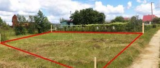
2. Research and inspection of the boundaries of a plot of land conducted by a specialist.
3. Development and “sketching” of a site plan for which land development work is being carried out. It is carried out by a cadastral engineer with the direct participation of a citizen - the owner of the land.
4. Notification of neighbors and owners of plots whose boundaries are in contact with the plot where boundary work will be carried out. This is necessary to ensure that conflict situations do not arise on this basis in the future.
This is important: during the land surveying procedure, the rights of owners of adjacent plots of land must not be violated.
5. Geodetic survey.
6. Processing of all results, their analysis and approval of a plan based on them.
7. Documentary preparation.
8. All received documents are submitted to the Cadastral Chamber for registration of a passport.
How to request a land survey in the Rosreestr of adjacent areas
- Prepare documents - civil passport, document confirming ownership of the plot.
- Submit the documents to the BTI and invite specialists to the site. Experts will inspect the territory and draw up a plan for carrying out the land surveying procedure.
- If neither the owner of the plot nor the neighbors are against the plan with boundaries, then specialists come to the site on the appointed day and take a photograph of the object, record, analyze and process the data.
- With the results of the work carried out, surveyors generate documentation, which is subsequently sent to Rosreestr.
- The documents are registered in Rosreestr and after some time the customer receives a cadastral passport.
- Information from geodetic and cartographic works.
- Information about soil, geobotanical and other surveys and surveys.
- Land quality assessment data.
- Information about the inventory of sites.
- Thematic maps of lands.
- Atlases of the state and use of lands.
- Land management schemes for municipalities.
- Information on surveying land management objects.
- Maps of land management objects.
- On-farm land management projects.
- Land management files of land surveying data created before January 1, 2009.
The delineation of a land plot establishes the location of the plot in relation to neighboring territories, which eliminates the emergence of controversial situations. Creating a land survey involves carrying out various works on the site, in particular, establishing boundaries and coordinates, measuring the area, etc.
A land survey deed is a document of title that contains all the information about this plot and its boundaries. If there is no land survey, then it will not be possible to register ownership of the land, and accordingly, the owner will not be able to conclude any transactions in relation to this land.
What information is generated in land management?
The land management file contains the following information:
- detailed information about the allotment - location address, area, intended purpose of the land;
- information about the owner - full name, residential address, contact phone number;
- a document on the basis of which the land was transferred to the owner - a purchase and sale agreement, donation, exchange, etc.;
- date of the survey procedure, results of the event;
- if there are buildings on the site, then you need to indicate detailed information about them - area, purpose, type, exact boundaries;
- information about the design organization that carried out the delimitation of the land plot - name, full name of the head, address of the organization;
- date of registration of the site for cadastral registration.
What documents are included in land management?
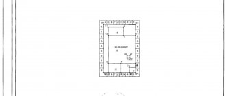
Land management has a clear structure. So, this set of data for the site includes:
- Title page.
- Table of contents.
- Explanatory note.
- Situation plan with information about the location of the work site.
- Act on the approval of the boundaries of a land plot.
- Catalog of coordinates.
- Plan of land boundaries.
- Technical passport.
- A copy of the document confirming the right to the land plot.
- Power of attorney – if the land surveying process takes place with the participation of a trusted person.
- Outlines for boundary signs.
- Sheets for calculating the area of land.
- State acceptance (inspection) certificate.
Where can I order land management work, or rather, land surveying work? Cadastral engineers deal with the issue of registration of land documentation.
How to get old land documents
In most cases, owners begin to deal with documents when the question arises of either selling property or entering into an inheritance. For example, grandfathers lived their whole lives in the village and had an agricultural share. And here the question arises: what documents should there be? What kind of pile of papers does grandma have? what should I go to the notary or the MFC with?!
In the 90s of the last century, land privatization was carried out during the “land” reform. The state issued a huge number of land documents to the population. At first, land committees carried out boundary work, then local administrations issued decisions on the provision of a land plot on a specific right. According to these resolutions, the following have already been formalized:
18 Apr 2021 klasterlaw 264
Share this post
- Related Posts
- Give a Positive Assessment to the Characteristics of Grandparents Raising a Grandson in Custody
- City of Yaroslavl Oktyabrsky Village Lights turned off Where to call
- Procedure for purchasing and selling an apartment in 2021
- Sample Apartment Building Management Agreement 2021