Cadastral registration
10
Each piece of land must be defined by boundaries. The formation of an allotment must be carried out on the basis of the layout of the land plot on the cadastral plan of the territory (hereinafter referred to as SRZU), approved by the local government body. This data is stored in the state register and is open to every citizen who accesses the official website of Rosreestr.
What is the layout of a land plot on the cadastral plan of the territory?
SRZU is an image with the boundaries of the formed plot or plots on the cadastral plan of the territory. This scheme is formed by cadastral engineers based on the results of land surveying.
The diagram must contain the area of each of the formed sections. If two or more plots are involved in the formation process, then their conditional numbers are present in the document. The scheme should complement the boundary work.
The preparation of the document is regulated by Article 11.10 of the Land Code. The requirements for its formation and form were approved by Order of the Ministry of Economic Development dated November 27, 2014 No. 762.
What it is?
The layout of a land plot or several (SRZU) is a graphic display of the boundaries of a newly formed plot (plots) of land on the official cadastral plan of the territory (KPT). It is designed to determine the actual location and size of the projected site for alienation, referenced on the ground.
The document is drawn up based on the results of geodetic measurements and taking into account the following materials:
- adoption of regional planning documents;
- development and land use standards established by legislative acts;
- territorial planning projects;
- the presence of specially protected areas;
- provisions on public land plots and established “red lines”;
- previously approved boundaries of other areas;
- location of existing and planned structures, unfinished construction;
- state and investment programs for the development and development of the territory.
Basic information is obtained from the state cadastre for a given specific territory.
Why do you need a layout diagram of a land plot at KPT?
The scheme itself is not a legal document. It is technical in nature and requires:
- to form a land plot from lands or other plots that are in state or municipal ownership, i.e. not privately owned;
- in the case of redistribution of land plots that are privately owned with state or municipally owned lands, the so-called addition.
The most common cases when preparing a memory layout diagram is required:
- required by a cadastral engineer to prepare a boundary plan in order to register it with the cadastral register and obtain the cadastral number of the plot;
- you own a state-owned plot on lease and want to divide it. In this case, approval of the scheme for dividing such a plot is required;
- want to register an empty plot of land that does not belong to anyone, receive it for rent or ownership (purchase) in accordance with the land code.
- may be required if a building permit is obtained.
In other cases, land is allocated by local authorities in accordance with the land surveying and planning project.
The scheme is approved for a certain period of time; according to the law, the period is 2 years .
How to make a site plan based on polar photography?
This method of shooting is used to plan open spaces limited by curved contours.
- We fix a sheet of checkered paper on plywood or a tablet. We fix the compass in the upper left corner, orienting the letter C (North) up (towards the top edge of the sheet).
- We select a point (pole) - the place from which we will film the area. The panorama is best viewed from an elevated position. The point should be in the center of the area being photographed, from where it is clearly visible. That is why such terrain survey is called polar - it is carried out from one point.
- Select the scale of the plan. We measure the distance on the ground that we will need to put on the sheet. Let it be maximum 300 m. Let’s measure our sheet - 10 cm x 10 cm? To choose the right scale, divide 300 by 10, we get 30. Our scale is 1 cm 30 m. We sign the scale at the bottom of a sheet of paper and draw a linear scale.
- We orient the tablet to the north, draw an upward arrow in the upper corner of the plan and sign north-south. When working, we constantly make sure that the compass needle points north. After orientation, we put a point on a sheet of paper, indicating the place from where we will shoot (we chose it at the beginning).
- We make a sighting on the main landmarks using a sighting ruler - we determine the direction and draw a thin line with a pencil on paper.
- We determine and sign the azimuths for these objects (the angles between the direction to the north and the object, measured clockwise) and plot the distance to them. How? First, we measure them on the ground - with a tape measure, field compass or steps, take the average step length of 60 cm. To calculate the distance, first multiply the number of steps by 60, let our distance be 10 steps, then we get 600 cm or 6 m. We transfer the distance to the plan, for this we divide 600 by the scale value: 600:30 = 20 cm (something turned out to be greater than the length and width of our sheet). We designate them (landmarks and objects) using conventional signs. The distance to an object whose height is known is easily determined. To do this, holding a pencil vertically in an outstretched hand, mark a segment on it that covers the observed object, and then this segment is measured. The required distance (S) is determined from the similarity of two triangles.
In order not to confuse where the azimuths are labeled and where the distances are, azimuths can be indicated by degrees, and distances in steps or meters.
Outlines of polar and route surveys
- After all the work completed, we received the so-called outline, but this is not a finished plan yet. The plan is drawn up in office conditions. On a blank sheet of paper, sign the scale again and draw a north-south arrow. Using a ruler and a protractor, transfer the entire drawing to this sheet at the selected scale. At the end of the work, draw a frame and sign the name of the plan inside it.
- On the plan itself, the names of objects are signed and designated by symbols. At the bottom of the sheet they write a legend of the plan - symbols with interpretation. There we already have a scale designation, and we also put the author’s initials there.
Determination of azimuths on the ground
Contents of the SRZU
The structure of the document must contain all the necessary information about the allotment in accordance with Art. 11.10 Land Code of the Russian Federation. The plot location diagram reflects the following information about the allotment being formed:
- conditional number;
- square;
- location;
- coordinates of boundary turning points;
- red lines;
- boundaries of territorial zones with established special conditions of use;
- position of permanent buildings;
- planning projects;
- boundaries of adjacent areas;
- drawing of the allotment being prepared;
- cadastral quarter number;
- description of the coordinate system;
- symbols;
- category of land.
It is preferable to conduct a topographic survey of the site and its surroundings. This entails additional costs, but will have a positive effect on an accurate reflection of the actual characteristics of the site. For example, it will show which communications run under the land plot, which will help avoid problems with its subsequent development.
Methods of working with the PAC resource
Using the example of one of the plots, we will analyze what information the numbers in the cadastral number hide. How to use the public cadastral map
Duplicates of information in the Unified State Register of Real Estate
Important! If the cadastral map, after entering the number, displays a plot marked “without border coordinates”, this plot is without land surveying, or there are errors in the USRN information about it.
You can connect the necessary conditions for displaying information in the “Layers” tab: OKS, land plots, zones with a special regime of use, thematic maps.
Using the example of one of the plots, we will analyze what information the numbers in the cadastral number hide.
·Information on OKS (capital construction projects) – buildings, structures, structures;
Stages of preparing the storage layout diagram
To obtain a diagram of its location, the initiator of the formation of a land plot must act in the following order:
The interested party prepares a statement about the need to prepare a layout plan for a plot of land. The basis for this is a document confirming the authority of the applicant regarding this plot.
A package of documents is being prepared that must be attached to the application. It includes:
- applicant's passport;
- title document for a plot of land (certificate of ownership, act of allotment of land, etc.);
- cadastral passport for land (if available) or extract from the Unified State Register of Real Estate;
- a certificate from the BTI, if there are buildings on the site, or a cadastral extract, if there are none.
The application with documents is sent to the cadastral engineer. Before starting work, a contract for the provision of services for the production of the circuit is drawn up.
The received documents are analyzed by a specialist for the presence or absence of grounds for refusal to approve the layout of the storage unit. To do this, he requests the registration data of the site in the form of a cadastral extract.
The diagram can be prepared in one of the following ways:
- Analytical.
- With a specialist visiting the site.
In the first case, preparation is carried out office-wise. The boundaries of the storage area are roughly designed and a layout diagram is prepared. In this case, there is a risk that after approval and registration of the right to the plot, you will receive an allotment that is not within the boundaries that you want. This is especially dangerous if there are some other real estate objects around the site you have chosen (other people’s sites, buildings, etc.). If there are risks of crossing the boundaries of someone else's property, it makes sense to prepare a diagram with a surveyor visiting. It's a little more expensive, but well worth the money if the land overlaps with neighbors.
Upon departure, the surveyor will determine the exact coordinates of the boundaries of this site and a diagram will be prepared based on them.
Receiving an official document. Its preparation usually takes from two to four weeks.
After approval, the cadastral engineer can prepare a boundary plan and conduct cadastral registration of this newly formed plot. At the exit, you will receive a registered plot with a cadastral number, and an extract from the Unified State Register will be issued.
After this procedure, you can begin the process of registering the right to a piece of land and you will have a property. Before cadastral registration, there can be no talk about a real estate object, since in accordance with Russian legislation, a real estate object arises after its cadastral registration and the appearance of a cadastral number.
A citizen can independently prepare this scheme using the Rosreestr portal. But not everyone has all the necessary information to check compliance with all regulations. This is a fairly large amount of information that a cadastral engineer usually has. Therefore, it is recommended not to waste time and contact qualified specialists.
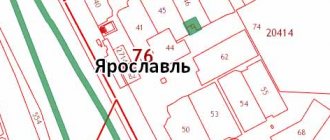
Sample SRZU for KPT 2021 :
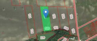
How to use the public cadastral map
The next tool is “Map Management”. It allows you to obtain a variety of materials, build thematic maps by land category or type of ownership, and include satellite imagery or other backgrounds. The primary information for obtaining information about a plot is the cadastral number. After clicking the “Find” button, the public cadastral map will display the information for you. The hint field will provide additional links for a more detailed study of the object if the standard data is not enough.
Plot owners often ask questions: has my plot been demarcated, has my neighbors been demarcated, the boundaries of the plot, etc.
What is a public cadastral map and why is it so useful for chairmen and individual owners of plots (read more...)
Important! The content of the search results area depends on the type of objects in question, on the presence or absence of information about them in the State Property Committee; if there is no information, the public cadastral map will display the error “Nothing found” when requested.
Registration of SRZU by the administration
In most cases, the initiator of the preparation of the scheme is an interested person: an organization or a citizen. The territorial administration is only obligated to formalize it in the event of the sale of a plot through an auction. The applicant bears all costs associated with the production and receipt of the SRZU.
The body allocating land sends an electronic scheme to Rosreestr. This is necessary so that no other plot is formed on this site until the rights to it are registered or in the next two years (the period of validity of the scheme).
A violation on the part of the administration is the requirement for the applicant to submit the scheme in electronic form. This requirement is illegal!
Who is responsible for preparing the SRZU?
According to current legislation, the following may draw up a layout diagram:
- cadastral engineer;
authority that has the authority to manage land.
Previous rules left this right exclusively to the district administration.
Is it possible to independently develop (prepare) SRZU?
Yes, this is allowed if:
- the land plot is located outside the residential area;
- when renting a storage unit, if no bidding is held for its issuance;
- if there is only one applicant participating in the auction;
- the citizen is the successor of the seized plot.
Let us consider the features of the preparation of SRZU by different performers in more detail.
Preparation of a site diagram by a cadastral engineer
Depending on the complexity of the project, cad. the engineer decides to draw up the SRZU either on-site or office-wise.
In the first case, the need for personal presence on site is dictated by the impossibility of determining the location of the object, the exact boundaries of the site, and controversial issues. The cost of the study will be higher, but the data obtained as a result of the visit can be used in the boundary plan.
If the cadastral specialist has all the necessary information on the land property, and topographic survey is not required, then the project is carried out directly in the office. At the same time, both the time and cost of work become noticeably less.
Registration of a site plan by the district administration
Local administrative authorities are responsible for drawing up the SRZU if the sale of land is planned to be carried out through an auction.
The remaining cases involve the registration of a SRZU by a citizen or legal entity interested in the acquisition. In this case, all costs are borne by the applicant.
Independent registration of SRZU
The law allows that the layout of a land plot can be completed independently by a citizen or organization. Provided that all documentation will be prepared in accordance with the requirements of the law, and the accuracy of the boundaries and corners of the land plot will be maintained.
When independently preparing SRZU, it is important to be able to use a geoinformation program and navigate graphic editors.
Independent compilation occurs according to the following algorithm:
- An electronic card of the storage unit of interest can be ordered on the Rosreestr website;
- Then it is transferred to a graphic editor (in this case, it is necessary to strictly observe its format and the accuracy of the symbols applied to the plan).
Important: Experts advise preparing the SRZU immediately in electronic format. Schemes drawn on paper are now a thing of the past, and with a high probability they will not be accepted by authorized bodies.
Based on the presented scheme, the administration makes a decision on issuing or rejecting the application for the allocation of land plots. A number of factors influence decision making:
- whether the submitted scheme complies with legal requirements;
- are there any important strategic or government facilities, agricultural fields, or nature reserves nearby;
- whether the land will be used to build residential buildings.
It may not be possible to pass the package the first time - it is difficult to take into account all the requirements at once. Just consult with a cadastral engineer or people who have previously received similar permits
. The scheme can be submitted as a new one after you correct the errors and redo the inconsistencies.
Reasons for refusal
In order for the scheme to be approved, it must comply with the requirements of the land code and, accordingly, should not meet the points that constitute grounds for refusal of approval. If the document meets all the requirements of urban planning regulations and legislation, then local government authorities are required to approve it.
According to clause 16. Art. 11.10 LC, reasons for refusal may be if the circuit:
- does not comply with the format or requirements for its preparation;
- has violations of the requirements of land legislation for the created plots;
- does not comply with the approved territory planning project, as well as the regulations on specially protected natural zones, urban planning standards;
- has other violations of land legislation.
They will also refuse if the boundaries of the area being created are:
- cross another plot already registered in the cadastral register;
- cross the boundaries of a land plot for which a scheme has been approved with a valid period;
- do not comply with the territory planning project or land management standards;
- within the approved survey project. In this case, it will become a problem to obtain the desired plot of land for rent or ownership. The solution here would be to include it in the project.
What to do if you receive a refusal?
Further actions of the person interested in receiving the scheme depend on the grounds on which the refusal was received.
In case of refusal due to a discrepancy between the data and the Rosreestr databases (cadastral error), you must submit a request to correct them. An option could be making changes and receiving an extract or refusal. Refusal must be submitted in writing, indicating the reason. Then with this document you can go to court, which, by its decision, will oblige the Rosreestr body to make changes.
If the administration refused to approve the layout of a plot of land due to non-compliance with the legal format or violation of preparation rules, then the applicant has the right to start the procedure again. This can be done again with the same cadastral engineer or contact another.
FacebookVKontakte
Grounds for refusal to prepare
Sometimes it is allowed to refuse to prepare the specified documentation and carry out the land surveying procedure.
A refusal can also be received at the registration stage, after transferring the documentation to the MFC. It may be associated with disorders:
- An application for the preparation of documentation or its registration was submitted by an inappropriate person who is not the legal owner of the land.
- The documentation package does not include all required documentation.
- One of the documents (several) has an invalid appearance - it has been damaged, worn out, etc. Provided that the recording made in it is blurred, erased or otherwise destroyed.
- The MFC registrar or cadastral engineer had doubts about the authenticity of the document (several documents).
- A cadastral error was identified in the form of a discrepancy between the accounting information and the real state of affairs. Read more about the imposition of boundaries here.
- Other shortcomings.
Route (contour) shooting
It is carried out along the line of a road, river, edge of a forest, along the shore of a lake and other more or less rectangular areas. The path is divided into points, between which distances are measured, and from each point azimuths are determined and distances to reference objects are calculated. In this case, the shooting is done in a mixed way. Order:
- at each point the tablet is oriented to the north;
- using polar photography or the method of perpendiculars, the main objects are plotted on the plan, then a line is drawn to the next point;
- measure the distance between points and plot it to scale on the plan;
- shooting from the second point.