Home / Real estate / Land / Cadastral registration / Cadastral number / Information about land by cadastral number
Back
Published: 07/03/2017
Reading time: 3 min
0
579
Copying a land plot is not one of the mandatory documents that the owner must have. But it may be needed when designing construction work on the ground.
- What is copying of a land plot?
- What information about a land plot can be obtained on the Rosreestr website using a public cadastral map?
- What information about a land plot can be obtained from the Unified State Register of Real Estate?
What is copying from the master plan of a land plot?
Copying a land plot is the traditional name of a document that is the logical conclusion of all geodetic work that has ever been carried out on the lands of a given territory. It contains information of a technical and geographical nature, plus all the necessary information about the state of the area and its significant objects. It comes in both color and black and white.
In other words, a copy of a land plot is a site plan made on the topographical basis of the territory of a municipality or other territorial division unit. Its maintenance will help you better understand what copying a plot of land is.
The legislative framework
The regulatory framework of the land plot scheme establishes a number of acts, decrees, orders and regulations directly related to the justification of this activity. The clarification points regulating the activities when obtaining a copy of a site are specified in the legal laws. The basis for all laws and acts is the Constitution of the Russian Federation.
The following in the hierarchy are international treaties ratified by the government, federal laws, regulations, presidential decrees and other acts. There are also regulations for the provision of municipal services. It regulates and establishes the rules of relations between the activities of the state and the citizen. Naturally, obtaining the required copying document is also regulated by the regulations of the legislation of the Russian Federation.
What does a copy of a land plot contain?
The copy should contain information about all adjacent land plots, nearby settlements, objects of resource significance (reservoirs, quarries, etc.), power lines (for connecting light), pipelines, etc.
I am ready to advise you free of charge by phone (24 hours a day, 7 days a week)
The call is free for all regions of the Russian Federation
If there are potentially dangerous natural or man-made objects nearby, they are also subject to mandatory registration and drawing on a plan map. In addition, places of concentration of groundwater and communications running underground are recorded.
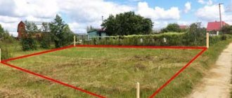
Sample copy of a land plot
What is site clearing, where to get it?
- application for a copy, where you must clearly indicate the cadastre number;
- ID card or similar document;
- certificate of municipal registration of building rights.
- documents confirming the right to own a land plot or a certificate from the Unified State Register;
To obtain a copy from the general plan, you need to prepare documents confirming your identity, as well as evidence of rights to the land plot under study (extract from the cadastre, ownership).
Where to get and how to get a copy of a land plot
To obtain a copy of a land plot by cadastral number or address, you need to prepare the following documents and then submit them to the territorial department of architecture:
- Application for the creation of a copy;
- A copy of the identity card, for legal entities - an enterprise card;
- Receipt of payment of the duty (check the amount of the duty on site);
- An extract from the Unified State Register of Real Estate for a land plot, to order which you will need a cadastral number or address.
Please note that Rosreestr sends extracts from the Unified State Register within 3 days (there may be delays). If you want to get information faster, I recommend ordering statements directly through the Rosreestr API - this way you will receive the document within a day. The cost is the same - 250 rubles, the official data is from the Unified State Register of Rosreestr and is confirmed by the registrar’s electronic digital signature (EDS).
Extract from the Unified State Register of Real Estate, which I recently ordered through the Rosreestr API
In order to inform state authorities, local governments, legal entities and citizens about the condition and use of lands, ensure the rational use of lands and their protection, as well as disseminate information on describing the location and (or) establishing the boundaries of land management objects on the ground, a state data fund is being created obtained as a result of land management.
What is the State Land Management Data Fund (hereinafter referred to as the SFDF)?
This is an archive of land management documentation, geodetic and cartographic products, which are produced during land management.
Land management represents one of the essential types of land relations, based on the need for a systematic organization of land use in the state, as well as the implementation of the formation of land management objects in accordance with the law.
The objects of land management currently are the territories of the constituent entities of the Russian Federation, the territories of municipalities, the territories of settlements, territorial zones, as well as parts of these zones.
SFRD is formed on the basis of collection, processing, accounting, storage and dissemination of documented information on land management.
How is such a fund formed?
Persons carrying out land management transfer free of charge one copy of the land management documentation prepared by them to the SFRD. This procedure is established by Federal Law No. 78-FZ of June 18, 2001 “On Land Management” (hereinafter referred to as the Law on Land Management). Land management documentation included in the SFRD is federal property.
What materials are contained in the SFRD?
In land legislation, agricultural lands have priority over lands of other intended purposes, as a result of which the SFRS materials are mainly aimed at protecting lands and increasing soil fertility, in particular, these are materials of soil, geobotanical and other surveys and surveys of state farms, materials for assessing land quality, materials for land inventory, materials describing the location of the boundaries of municipalities, settlements, territorial zones and zones with special conditions for the use of territories, on-farm land management projects, projects for the reclamation of disturbed lands, materials of state land monitoring, including reports “On the availability of lands and their distribution by type of ownership, categories, lands and users” by district.
Also in the SFRD, land management cases on land surveying of land plots, which were used to register land plots for cadastral registration (2002 - 2008), until new requirements for documents on land surveying were established (before the order of the Ministry of Economic Development of the Russian Federation came into force 24.11 2008 No. 412 “On approval of the form of the boundary plan and requirements for its preparation, an approximate form of notice of a meeting to agree on the location of the boundaries of land plots”).
What are the conditions for providing SFRS materials?
The provision of SFRD materials is carried out in accordance with the administrative regulations for the provision of state information, approved by order of the Ministry of Economic Development of the Russian Federation dated November 14, 2006 No. 376 (hereinafter referred to as the administrative regulations).
Who can use the SFRD materials, and what documents must the applicant submit for this?
SFRD documents can be used by any interested parties who request land management documentation in an application form. To do this, you need to contact the Rosreestr Office in the Krasnodar Territory in person or by mail. Depending on the access classification, land management documentation is divided into “O” - open, “DSP” - for official use, “S” - secret and “SS” - top secret.
When applying in person, an application in the established form is provided, as well as a document certifying the identity of the interested person or his authorized representative, if the applicant is acting by proxy on behalf of the interested person - a power of attorney.
When applying by mail, interested parties submit only an application. The application must indicate the address of the recipient of copies of the SFRD materials if the land management materials are open and publicly available. To obtain restricted access information, interested parties submit an application and the original document (or a notarized copy thereof) entitling them to receive restricted access documents from the SFRS.
The documents that give the right to receive SFRS documents classified as information to which access is limited are:
- original or copy of the title document for the land plot, upon application by the copyright holder;
— the original power of attorney issued by a notary, or its copy issued by the copyright holder or his legal representative to receive information and confirming the authority of the person who received such a power of attorney from the copyright holder or his legal representative;
- the original document (letter, certificate, etc.) issued by a notary, including certified by him with his signature and personal seal, and confirming the right of the person who made the corresponding request to inherit the land plot of the copyright holder by will or by law;
— a license to carry out work using information constituting a state secret.
The originals of the SFRD materials are provided to interested persons without the right to remove them from the premises of the SFRD Office. An interested person cannot request more than ten storage units at a time - documents with an inventory number (tablet, map, land management file, etc.). During the working day, the time for working with original SFRD materials is not limited.
Extracts and copies from SFRD materials, if equipped workstations are available, are made by users independently.
How long does it take to provide SFRD materials, and is there a fee?
The deadlines for providing SFRD materials for use by interested parties (in person), or a reasoned refusal to provide them, as well as a notice of absence from the SFRD are prepared within a period not exceeding 3 business days from the date of receipt of the application.
If you apply for SFRD materials by mail, the provision of copies of materials, a reasoned refusal to provide them, or notification of absence in the SFRD is made within 15 days from the date of receipt of the application.
SFRS materials are provided to all interested parties free of charge.
To obtain information about the availability and procedure for providing SFRD materials in the Slavyansk region, you can contact the Intermunicipal Department for the Kalininsky, Krasnoarmeysky and Slavyansky districts of the Rosreestr Office for the Krasnodar Territory in person, by phone 8 (86146) 4-11-90, by mail in Slavyansk- on-Kuban, Protochnaya St., 136/2, by email This e-mail address is being protected from spambots. You need JavaScript enabled to view it.
Copying from or from a plan
In my work profile I often come across this phrase. I wish I could write it correctly. Copying from the plan confuses me (from something). And copying from the plan confuses others. Although we are copying from a paper source (document). Please help me figure it out. With reference to the source
1) Look at the synonym copy . We say: a copy of a painting - without any pretext at all, the analogy here requires “copying a plan”; the pretext can only be brought into the process - to make a copy from the painting - “to make a copy from the general plan.”
Copying an apartment
In his life, a person often has to deal with various documents that he learns about for the first time. One of such documents is a copy of the apartment. What is this document and when might you need it? Let's try to figure it out within the framework of this article.
In order to check whether there was a redevelopment, you need to study the copy of the apartment in detail. Everything that is marked on it according to the results of the last inventory must be in its place in the apartment. If some element is missing (a wall, an opening, a built-in niche), it means that the apartment has been remodeled since the last inventory.
What is a technical passport of a real estate property?
If a copy is required for connection to electrical networks, gas supply, or water supply, then it must indicate the exact position of the points where this connection can be made. To carry out legal operations with the site, a copy is made from the cadastral plan, which precisely indicates the coordinates of the turning points of the site, its boundaries and area.
The main thing to remember about the technical passport
Our readers, who shared their experience of obtaining a copy from government agencies, were very disappointed by the length of this seemingly simple process. Despite the fact that copying from the finished master plan is done in one working day with the payment of a small amount of state duty, their attempts to save money resulted in long walks along the corridors and collection of unnecessary certificates. As a result of bureaucratic troubles, they lost not only precious time, but also significant funds, since their financial, construction or business plans were disrupted.
This is interesting: What will happen in the place of coupons for travel in city transport for Labor Veterans in Michurinsk, Tambov Region
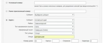
To obtain official confirmation of the cost of a plot, you need to obtain a certificate of the established form from Rosreestr. You can order it here. When filling out the application, you must pay the state fee online, indicate the cadastral number of the plot, and an email address for feedback; the document will be delivered to this address. It will take no more than fifteen minutes to complete the application. The applicant will be able to receive the supporting document within two days.
Topographic survey (Topography) of a land plot
It is also necessary to order a topographic survey of a land plot to update existing documentation when conducting legal transactions with real estate (purchase and sale, registration of inheritance, leasing, donation). In such cases, the topographic survey we perform, the price of which is a small fraction of your total costs, makes it possible to obtain high-quality, updated documentation for the financial transaction.
has been working for its clients for over ten years. The topography of Moscow and the Moscow region has been thoroughly studied by our specialists. Therefore, we can say with complete confidence that any task will be completed on time and at a price acceptable to the customer. For many of our regular partners, the question is: where to order topographic survey? – has long lost its relevance. They are confident that our company will cope with any assigned task in the best possible way. They were repeatedly convinced of this:
Sample application for copying from the general plan
- The applicant applies to the town planning department with an application for a copy and the necessary documents.
- The application is registered within 24 hours if there are no grounds for refusal of registration.
- After reviewing the application, the head of the department makes a decision on providing the requested documents.
- Department employees check the package of documents for compliance with the regulations.
- Administration specialists prepare a copy and inform the applicant of its readiness.
- The applicant receives the requested documents. The waiting period cannot exceed 20-30 days.
The list of what should be indicated in the master plan and the rules for its execution are regulated by DBN B.1.1-15:2012. The meaning, procedure for development and structure of the master plan are described in Article 17 of the Law “On Urban Planning Activities”. Based on it, a zoning plan and a detailed plan are developed.
A citizen of the Russian Federation can receive a copy by applying personally with an application or requesting information by Russian post at the administration of a municipal entity (city, settlement, etc.) or at the Committee for Architecture and Urban Planning (in Moscow - Moskomarkhitektura, in the Moscow region - Mosoblarkhitektura, in St. -Petersburg - Committee on Urban Planning and Architecture of the City of St. Petersburg).
A copy is a fragment of the general plan of a settlement, urban or rural district, reflecting basic information about the external characteristics of a site or several sites (a group of neighboring sites). The copy can also be called a “reference plan”, since surveyors or the owner himself rely on it when carrying out cadastral and geodetic work, topographic surveys, construction, and study of the area.
The meaning of the word "copy"
- planning and carrying out any types of work on a plot of land;
- clarification of information about the allotment that may be needed in connection with the implementation of economic and other activities;
- provision of complete information to the buyer or interested party.
Sample copy from the master plan of a land plot
It is not mandatory when carrying out various transactions and work, but may be required to be submitted to Rosreestr and other authorities when planning construction work on a site, as well as for its zoning.
All this data is necessary to clarify the possibility of connecting various communications to existing or planned objects. In addition, it is very important to display all the infrastructure near the site in order to have an idea of the presence of potentially dangerous objects.
The copy contains geographical and technical information regarding a specific land area. In addition, the document includes characteristics of the state of the area and various objects.
- a free-form application from the owner of the plot indicating all the necessary details of the applicant and the cadastral number of the plot;
- an extract from the Unified State Register of Real Estate - you can order it here;
- title document for a plot of land;
- applicant's identity card. If a trusted representative acts on behalf of a legal entity, then a power of attorney, his passport and an organization card indicating its full details (extract from the Unified State Register of Legal Entities) will be required.
- a copy of a passport or other identity document;
- cadastral plan of the site;
- cadastral passport for the plot;
- certificate of state registration / extract from the Unified State Register of Real Estate, other title documents;
- registration certificate for buildings located on the land plot.
It represents a diagram of a certain segment of the territory. Done on A4 sheet in color or black and white. It is acceptable to use two options for the scale ratio (1:5000 or 1:2000) depending on where the plan will be provided. The drawing is drawn up in accordance with the standards of the Town Planning Code of 2004. It must contain all the information about the declared plot with a detailed drawing of the surrounding space. The following are shown graphically:
A copy is an exact fragment of a general, situational, topographical or other plan, so it should look the same as this plan. It can be color or black and white, have different scales and symbols, different functional zones and composition, but will always be made in the form of a topographic map of the area depicting land plots, their boundaries and objects located around them.