To carry out purchase and sale transactions and other real estate transactions, you must know the cadastral number of the property. If this numerical code is recorded, then this indicates that the plot or premises is registered by the cadastral chamber. The responsibilities of the administrative body include determining the boundaries of land plots, conducting land surveying, as well as the entire range of cadastral operations. The importance of having a cadastral number is determined by the provisions on real estate transactions, which may become impossible in the absence of personal registration.
What it is
When completing transactions with real estate, its owners often have the question of what exactly a cadastral or individual number is by legal designation. According to the law, during cadastral and technical registration, each object belonging to the category of real estate is assigned an individual number, which is considered to be a cadastral number. The personal code is entered into the register and is confirmation of the right to property. Entering a digital or alphanumeric code into the cadastre is necessary to identify the object. Using the number code, you can determine the exact location of the site.
Basic Concepts
To study the structure of the cadastral number, we will need concepts such as: cadastre, cadastral district, quarter, district. The number is directly associated with them. We will expand on other terms as needed.
Cadastre – state accounting, register, real estate objects. In this case, we are only interested in the land cadastre. It is divided into three levels:
- federal. The entire land of Russia;
- subjective. Land of the subjects of the Federation, republics. Regions, territories, etc.
- local government. Land is managed by municipalities, village councils and the like.
The entire territory of Russia is divided into cadastral districts. Cadastral district is the territory of a subject within its administrative boundaries.
The district is divided into cadastral districts. These are the territories of the subject's districts within the administrative boundaries.
The districts are accordingly divided into cadastral quarters . These are the territories of entities on which land plots are located. Each plot is assigned a unique identification code, called a cadastral number.
How to decipher the site number
When deciphering a digital record entered into the state cadastre, the groups of numbers present in it are considered. The total numerical value is distributed into 4 groups, often separated by signs. Each category of numbers carries its own information load. In this case, the rule of absolute uniqueness of the code is observed. The number assigned to the property is deciphered as follows:
- the first digits determine the regional affiliation of the object;
- the next digital group indicates the territorial district, which is the location of the object;
- the third block gives information about the quarter;
- the final fourth digital combination stores information about the object itself, this is the personal number of the site.
In order to correctly decipher the information hidden in the individual code, you need to know which territorial units are designated by different digital combinations. An electronic map can help with this.
What does the number look like?
To understand what the cadastral number looks like, you need to review the existing documentation that relates to the land plot. This unique code is assigned to a territorial object after registration in the Federal Cadastre with the help of independent specialists.
The cadastral number allows you to carry out various property transactions with a land plot. Without it, no transactions can be carried out even with the full consent of the parties
. A regular number consists of at least twelve digits.
The identifier that is assigned to buildings and land plots is located at the top of the cadastral document containing all the information relating to the mentioned objects. It should be noted that the number consists not only of numbers, but also of characters
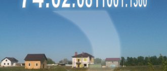
. For example - 46: 56: 03 07 11: 008.
There are numbers that are written without spaces. This option is provided for by the nomenclature acts of Rosreestr
. It is used in specific regions of the country, which is determined by the department dealing with land management of the region.
What does it consist of?
If we consider the number by numerical values up to the “:” sign, we can distinguish the following data:
- cadastral district;
- area;
- quarter;
- land plot number (all digital values).
The cadastral number is a complex code that is formed using numerical groups separated by problems and colons. It should be noted that the first two digits coincide with the license plate values of vehicles that are registered in the same region as the land plot.
The expansion of the cadastral number is relevant for large cities, in which the internal administrative division significantly exceeds the territorial division in small localities. Therefore, there may be differences between the regions for which individual cadastral codes are generated.
Structure of the cadastral number of a land plot
All numbered designations of objects must be subject to the general rule. According to the established structural format, what the numeric or alphanumeric inventory combination looks like is important. The first two digits indicate the cadastral district, the next two indicate the cadastral district, the four- or six-digit combination that follows indicates the quarterly location of the site. The last four digits contain information about the object itself. In total, an individual number can have from 10 to 16 digits. The standard option is 13 digits.
Decoding
The first two digits of the number, as mentioned above, coincide with the code that determines the region of the country. Such a solution allows you not to get confused about the territorial relation of a specific land plot, immediately attributing it to a certain part of Russia.
The first numerical value, therefore, never changes, since the position of the land plot cannot be changed by moving it from one part of the Russian Federation to another. Based on this, we can judge why the remaining digital parts of the code change.
For example, the administrative division of the city changed, new districts appeared or several old ones were merged, existing internal boundaries shifted. For each of the mentioned situations, you have to change one numerical value, which can consist of either two digits or more.
The second pair of numbers indicates the regional ratio of the land plot. If we are talking about the internal administrative division of the city into districts, this numerical value is different, since two different areas located in two parts of the city do not belong to the same group territorially.
The third group of number values denotes the so-called cadastral zone. It is divided into three categories:
- zone;
- array;
- quarter.
The third group is divided into paired values. If the number increases, then the new number is added to the last pair of the group. Eg:
- 46: 56: 03 07 11: 008;
- 46: 56: 03 07 111: 008.
The fourth number group indicates the individual registration number of the property. The meaning may change depending on its composition. There are three groups:
- land plot without buildings;
- ZU with erected buildings for various purposes;
- the number value of the residential premises (apartment) located in the building.
It should be noted that large cities that experience overpopulation add one digital value to the last group when the need arises.
Assignment of cadastral number:
- The number serves as a unique identifier, which allows you to systematize the available Rosreestr information according to established categories.
- The number allows the property owner and other interested parties to find out all available information about the site, which includes the postal and cadastral address, the area of the land plot and its borders with adjacent land, the established technical characteristics of the land plot, the value of the taxable object (specific and total).
- Admission to various financial transactions with land (sale, lease, purchase, inheritance, etc.)
Example of a cadastral number
An example of what such a number looks like will help you more accurately understand how to correctly decipher it. Symbols of territorial units are transmitted by digital code.
Examples:
| 68:20:2101007:44 | Tambov Region | Tambov district | Streltsy village | St. South, house number |
| 47:23:1203001:810 | Leningrad region | Gatchina district | Gatchina | Coordinates of the site in the register - street, house number with fraction |
You can find out what the digital combination means in online resources. Typically, the first block of the cadastral cipher is equivalent to the number combinations of vehicles in the region. The third block of the cadastral code contains the largest amount of information. It contains the coordinates of the zone, array and quarter.
Why do they change the cadastral identifier?
Its change is necessary if changes have occurred in the memory parameters. Changes include the following:
- change of location address;
- changing the boundaries of the territory as a result of land surveying;
- consolidation, division of land plots with other plots.
In these situations, the old cadastral number is liquidated. It is no longer valid: you will not find the site using it online on the Public Map. In addition, the local administration has the right to remove cadastral N on its own initiative. This occurs in a situation if, after five years from the date of registration of the plot with the registering authority, assignment of an identifier, the plot was not legally registered. To change the cadastral number or obtain a new decoding, the land user contacts the branch of the registration authority. This is Rosreestr, operating at the applicant’s place of residence. Also - to the MFC, but the period for consideration of his application will be extended due to the fact that the MFC does not directly resolve legal issues.
Obtaining information via the Internet
You can find out detailed information about the site using online sources. If you have a cadastral number, this is not difficult to do. A schematic representation of any registered plot can be found on a special cadastral map. The electronic version of the state register is available around the clock and contains complete information about all real estate objects that have an individual state registration code. There is no charge for submitting a site plan electronically.
Important! The disadvantage of this method of obtaining information about the desired object is possible errors in the information due to the provision of outdated information.
A more reliable option for cadastral research is to go to the Rosreestr website. After submitting an official application, the application will be reviewed within 5–10 days.
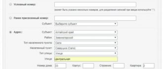
The sequence of actions when submitting a request to Rosreestr is as follows:
- Log in to the official website of the company.
- In the Electronic Services category, find the Go to Sections button.
- Next, find Help information in the services.
- Fill out the feedback form, indicating the exact postal address of the object.
- Next, you need to type Create a request.
In response to the request, information on the site will be provided. An extract can be obtained by applying online and by visiting territorial departments. To obtain an extract on the Rosreestr website you will need to do the following:
- Determine personal status in a special category - individual or legal entity.
- In the Electronic Services section, select Receiving data from the Unified State Register of Real Estate with the ability to draw up a cadastral plan.
- Enter the required data into the form.
- Determine the option for receiving an extract.
- Provide an email address to send documentation electronically.
- At the final stage, you need to make sure that all data is entered correctly.
What does it consist of?
The structure of the cadastral number of a land plot consists of twelve or more digits , connected in pairs and groups, separated by colons. Spaces are allowed in the third sector. Twelve digits is the standard into which real estate in small regions located in central Russia fits.
The East, North-Eastern zone of the country, the middle and northern Urals are distinguished by large cities, in which not only vast land masses, but also numerous buildings that require registration and accounting.
Accordingly, the cipher here is much more complex and has more characters in the third and fourth sectors. Numbers are also arranged in groups, separated by colons, allowing spaces.
The same can be said about such major centers of federal significance as Moscow and St. Petersburg . The city of Sochi, which has been upset in recent years, belongs to the same category of centers whose cadastral numbers allow for going beyond the regulations established in 2007.
In the capital and other centers there are also standard twelve-digit numbers that characterize the initial registration of real estate, starting in 2007. Subsequently, with the filling of the original structure of the codes, the need arose to expand it.
It is noteworthy that the structure of the cadastral number of a real estate property always assumes the first digits in the amount of 2 pieces. They completely coincide with the number of the region where the land plot or building is located. These signs are completely identical to those indicated on vehicles registered in a particular county.
Knowing your cadastral number you can:
- determine the cadastral value of the property;
- find the owner's details and area of the plot.
If you only know the address, then you can use it to find out the cadastral number of the apartment, house or land plot.
Other ways to find out the cadastral number of a property
In addition to obtaining information from Internet sources about an individual number in the cadastre, you can use other available methods to resolve this issue. The most acceptable option is to contact the cadastral chamber, which is located in the city or district administration at the place of registration of the site. This option eliminates the possibility of error, since all information is carefully checked.
To apply, you only need a passport. You will also need to indicate the exact address of the facility. Based on the information provided, an employee of the administrative unit will search for information using the available coordinates. Contacting an official institution allows you to obtain the necessary document based on reliable information.
Private companies also provide information about sites. This type of service is provided on a paid basis. The cost may vary and range from 600 to 2000 rubles. The advantage of this method of obtaining information about a land plot is the possibility of providing express services. Specialized companies provide the following information:
- site plan;
- location of permanent and non-permanent buildings;
- exact cadastral code;
- number of storeys of buildings;
- date of registration of the object with state registration;
- area parameters;
- property type.
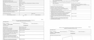
Some information can be obtained independently using the available data in the cadastral passport. Typically, column No. 1 contains information about the registration number. Column No. 11 establishes the cadastral value of the property. For greater reliability, when obtaining information independently, you should use at least two sources - the object’s passport and an online map.