Home / Real estate / Land / Cadastral registration / Cadastral number
Back
Published: 06/25/2017
Reading time: 5 min
0
804
Documented cadastral registration in Rosreestr is ensured through nomenclature numbers assigned to each property upon its registration. These numbers are used to perform registration actions and keep records of transactions carried out with the object.
The cadastral number of a land plot is a unique code that allows you to obtain the most detailed information about the property.
- What does the cadastral number of a land plot consist of?
- Decoding the cadastral number
Features of number assignment
Cadastral number is a unique digital sequence that is assigned to a real estate property when registering with the state. Unlike an address, such a code allows you to accurately identify a property and avoid confusion when conducting legal transactions.
The rules for assigning cadastral numbers are established by Order of the Ministry of Economic Development of the Russian Federation (Ministry of Economic Development of Russia) dated November 24, 2015 N 877 Moscow “On approval of the procedure for cadastral division of the territory of the Russian Federation, the procedure for assigning cadastral numbers, registration numbers, and register border numbers to real estate objects” . According to the Order, the entire territory of Russia is divided into cadastral units: districts, districts and blocks. The assignment of numbers in the cadastre occurs in accordance with this division.
The number assigned to a plot of land includes four parts, each of which is a cadastral division unit code. For example, the digital sequence 66:41:0313009:1669 carries information that the plot of land numbered 1669 is located within the block 66:41:0313009, where 0313009 is the block code, 41 is the district code, and 66 is the subject code Russian Federation (districts).
The cadastral number is valid until the plot ceases to exist: for example, as a result of division or merger with another plot.
What does the cadastral number of a land plot consist of?
The structure of the cadastral number is represented by twelve digits, combined into groups, which are separated from each other by a colon. In addition, the cadastral number may contain spaces.
The structure of the cadastral number is hierarchical and consists of four levels. It is presented in the following format: AA:BB:SSRPLL:KK.
The following information is hidden behind the letter designations:
- AA – cadastral district. In the first place, numbers are always put down that coincide with the number of the region of the Russian Federation, within whose borders the state cadastral registration of land is carried out.
- BB - cadastral region. These numbers indicate part of the cadastral district (an administrative unit of a subject, for example, a district of a particular region).
- ССРЛЛ – designates part of the territory of the cadastral region - cadastral quarter. Usually these are small settlements, microdistricts (neighbourhoods) of the city, etc. These numbers indicate the smallest territorial unit of the cadastral district, which is recorded on the duty cadastral map and recorded in a separate section of the state register. This level can be designated by no more than 7 digits, which indicate the code of the zone, area and quarter.
- КК - number of the land plot. This code often does not have the same meaning as the number of a gardening plot or other association. For example, garden plot No. 3 may have cadastral plot number 647.
The most common cadastral number consists of 13 digits (typical). But in practice, a different number of numbers is often encountered.
Thus, twelve digits contain the numbers of real estate located in small regions. The central part of the country fits into this number of symbols. In large cities, which are characterized by large areas of land occupied by real estate, registration actions are carried out using more complex ciphers (with the exception of objects registered for the first time, which are assigned standard 12-digit cadastral numbers).
Due to the large number of objects requiring registration, the number of symbols indicating cadastral blocks and numbering of land plots will be greater. Therefore, the cadastral number will consist of more than 13 digits. The maximum number of digits is 16.
It is worth noting that increasing the number of characters designating a cadastral district is unacceptable, since its designation is always identical to the region code.
Often in documents you can find a cadastral number in which there are no spaces between the values of the third sector. Such an entry does not lose its meaning, and a similar format is acceptable by the nomenclature acts of Rosreestr, approved by the departments responsible for land use and land management on the basis of the legislation on the state cadastre.
A donation agreement for a summer cottage between relatives is one of the simplest documents in legal terms. What is the result of land surveying and what does the survey document look like? You can find out by reading our article. The cadastral extract can be ordered online. You will learn how to do this here.
How to find a site by number
The cadastral number allows you to determine the exact location of the property.
To find a plot of land by number, just use an online service for checking real estate or a standard search on the portal www.rosreestr.ru.
For this:
- Enter the number in the search bar;
- Go to the property page.
The page will provide general information about the site: full address, area, registration date and data update date, cost, as well as the number of owners and details of the registration certificate.
Please note that starting from 2021, all information about real estate, including state cadastre information, is stored in the Unified State Register of Real Estate (USRN).
Detailed information about the land plot can be obtained from the extract from the Unified State Register of Real Estate.
Department of Property and Land Relations
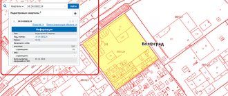
Each piece of real estate, information about which is included in the state real estate cadastre, has an unchangeable, non-repeating state registration number - a cadastral number. Cadastral numbers are assigned to real estate objects by the cadastral registration authority (in the Belgorod region, the branch of the Federal State Budgetary Institution "Cadastral Chamber of Rosreestr" for the Belgorod region).
Keeping records of capital construction projects in the state real estate cadastre has been carried out relatively recently - in the Belgorod region since 2012. Previously, real estate accounting was carried out by technical inventory organizations (BTI), which, during such accounting, also assigned numbers to real estate objects, which were called registration, conditional or cadastral numbers.
When previously registered real estate objects were entered into the State Property Register, they were all assigned new cadastral numbers, formed according to the rules for maintaining the State Property Register.
The cadastral number assigned by the cadastral registration authority is as follows: 31:XX:XXXXXXX:X. For example, 31:16:0123029:163. Cadastral (conditional, registration) numbers previously assigned by the BTI look different. For example, 31:16:0:0034:043679-00/003:0001/A2/0079.
In order to find out the cadastral value, you need to know exactly the “new” cadastral number in the format 31:XX:XXXXXXXX:X. However, in your title documents for real estate, if they were drawn up before the start of maintaining the State Property Committee in relation to capital construction projects, the “old” BTI number will be indicated. You can easily find out the “new” number for your property by using the “Reference Information on Real Estate Objects Online” service of the official website of Rosreestr https://rosreestr.ru.
To do this, just enter the old cadastral (conditional) number in the “Outdated number” column of the “Reference information on real estate online” service (in our example 31:16:0:0034:043679-00/003:0001/A2/0079 ). Next, you need to click the “Generate request” button. As a result, we receive information about the new number of the property.
Please note that re-issuance of certificates of registration of rights in connection with the assignment of a new cadastral number is not required, your documents are valid, information about the correspondence of old and new numbers is stored in the data of the state information systems of the State Property Committee and the Unified State Register.
If you do not have the opportunity to use the Internet service to find out the new cadastral number of your property and its cadastral value, or for some reason you were unable to obtain the necessary information on the Rosreestr portal, then you can request a cadastral certificate about the cadastral value from the State Property Committee. To do this, you need to contact a branch of the Federal Cadastral Chamber of Rosreestr or a multifunctional center (in person or send a request by mail). The cadastral certificate will be provided free of charge no later than 5 working days from the date of receipt of the request. When submitting a request, you must indicate the method of receiving the finished document: during a personal visit to a branch of the Federal Cadastral Chamber of Rosreestr, at the MFC or by mail.
What do the numbers on the Cadastral Map mean?
In the modern version of the cadastral number, buildings on a land plot are not taken into account , since a separate numerical identifier is now provided for them.
- the site has changed its physical address;
- the boundaries of the allotment were changed during land surveying;
- The land plot was combined with other plots;
- the land plot was divided into several smaller plots.
·Information on OKS (capital construction projects) – buildings, structures, structures;
Deciphering the “cadastral code”
The land plot number according to the cadastre is unique, which means it is a non-repeating code. Deciphering the cadastral number will help determine the characteristics of the territory of interest to users. Each of the digits included in the number has its own purpose. The numbers show the interested party which region and district the land plot belongs to, and also supplement other necessary information about the territory.
Cadastral number structure
Structurally, the identifier consists of 4 sections: digital blocks arranged in strict order. Each section is useful because it contains certain information.
For example, let's take an arbitrary area. It can be found in the Public Cadastral Map at number 13:19:0202001:53. The identifier consists of 4 blocks:
- 13 – 1st. This is a digital code assigned to the cadastral district. In this case – Moldova. The numbers of the cadastral district do not change and correspond to the code of the territory’s balance holder.
- 19 – 2nd. This is the N of the cadastral region, which is defined for a given district. In this case, 19 is the code of the Temnikovsky district.
- The 3rd block, consisting of 7 digits, indicates the cadastral quarter.
- 4 – 53 is the identifier of the land plot itself.
There are 13 digits in N. What are they needed for? In order to be aware of the characteristics of the memory. By cadastral number, the land plot can be found on the Public Cadastral Map online.
Conditional cadastral identifier
If a land plot is not listed in Rosreestr, it is not assigned a cadastral number, it only has a conditional identifier. For example, it could be a number that existed for the site earlier, before the introduction of new identifier samples, before 2007.
Why do they change the cadastral identifier?
Its change is necessary if changes have occurred in the memory parameters. Changes include the following:
- change of location address;
- changing the boundaries of the territory as a result of land surveying;
- consolidation, division of land plots with other plots.
In these situations, the old cadastral number is liquidated. It is no longer valid: you will not find the site using it online on the Public Map. In addition, the local administration has the right to remove cadastral N on its own initiative. This occurs in a situation if, after five years from the date of registration of the plot with the registering authority, assignment of an identifier, the plot was not legally registered. To change the cadastral number or obtain a new decoding, the land user contacts the branch of the registration authority. This is Rosreestr, operating at the applicant’s place of residence. Also - to the MFC, but the period for consideration of his application will be extended due to the fact that the MFC does not directly resolve legal issues.
Documents for changing the cadastral number
Any legal process is accompanied by the collection and preparation of documents, with their subsequent submission to the authorized bodies. The list is as follows:
- identification document;
- extract from the Unified State Register of Real Estate;
- plan: boundary, cadastral;
- passport (cadastral);
- a document that confirms that the local administration agrees to the owner changing the cadastral number.
What is a change of cadastral number? These are the actions of the owner of the land plot to replace the unique identifier. The action of the copyright holder is of a declarative nature. You need to fill out the application, having the form in hand in advance.
Cadastral number is an identifier of a land plot, which gives an understanding of what the plot is.
Take advantage of free legal advice!
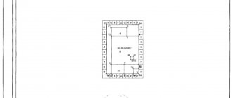
Document structure
From the extract generated on the basis of the cadastral file, you can also find out: What it looks like externally
Receiving the information
- no buildings;
- with buildings having different purposes;
- assigned to an apartment (premises) located in a building located on the site.
Proving your right to land in court, which is exactly what owners, including municipalities, have to do, can only be done if they have technical documents.
What is a real estate cadastral number
Each property registered in the Unified State Register of Real Estate (USRN) on the territory of Russia is assigned a unique number, which allows you to accurately determine and identify land plots, houses, bathhouses, apartments, parking spaces, etc.
This number does not change when any changes are made to the characteristics of the object, and when the property is removed from the state cadastral register, it cannot be reused for a newly created object.
How to obtain an extract from the Unified State Register of Real Estate for a plot of land, house or apartment
You can order an extract from the Unified State Register through the MFC by filling out an application. You must take your passport with you, provide the registrar with data about the object (cadastral number or address) and pay the state fee for obtaining information from the Unified State Register of Real Estate.
It should be noted that there are 2 types of statements: in electronic form, then it will come to you by mail, or in printed form, then to receive it, you will have to visit the MFC again.
The fee for an extract from the Unified State Register varies depending on the type, so the price of a paper certificate at the MFC is 750 rubles for an individual, 2,200 rubles. For the company. The electronic version costs 300 rubles. and 600 rub. respectively.
It is noteworthy that the paper and electronic versions of the document are no different legally. A paper document is certified with a manual signature, an electronic document is certified with a digital signature of Rosreestr. Both methods of document certification are equally legal.