The territorial division of areas into simple units is akin to gradation of length. For ease of measurement, the meter is divided into small and large parts. A millimeter is the smallest segment, and the largest is a decimeter, containing 10 millimeters in the template.
In a nutshell: the land cadastre is divided in the same way into individual plots, blocks, districts and districts.
In this article we will talk in detail about what a cadastral quarter, district, district is. What does the plot number on the cadastral map mean, how is it assigned and what is it used for.
Land zoning
In accordance with (hereinafter referred to as the Land Code of the Russian Federation), the lands of the Russian Federation are divided according to their intended purpose into seven categories:
- water fund;
- forest fund;
- settlements;
- agricultural purposes;
- specially protected areas and objects;
- stock;
- special purpose.
This makes it possible to determine the legal regimes of areas and zoning them to establish the order of use. For example, such non-targeted exploitation as the construction of residential buildings on the territory of military installations in populated areas is not permitted.
Zoning occurs according to the territory development plan. The decision to allocate different zones of a settlement is made by territorial bodies of state power or local government.
Dividing lands into zones allows for the subsequent formation of their territorial units. Thus, the entire area of the country is divided into land units called blocks, districts and districts. Thanks to this, the accounting of real estate objects is systematized.
Learn more about how land zoning works.
What is it needed for
A cadastral number is a unique set of numbers in all databases of the Russian Federation. It is assigned separately to each property when it is registered with the state. The latter is implemented in strict accordance with the procedure regulated by the Russian legislative framework, namely the Federal Law “On state registration of rights to real estate and transactions with it”
.
The cadastral number is assigned to the object as long as it exists in the form of a single legal object
. It allows you to quickly obtain comprehensive information about the site or building to which it has been assigned.
The cadastral number is retained for the entire period of existence of the land plot as such. It must be entered into the electronic databases of the local administration. There can be no grounds for changing the cadastral number
. Even a change in the owner of a land plot or its intended purpose is not considered a sufficient reason for changing its number value.
The cadastral quarter of a land plot is the boundary of the building lines within each base quarter. This is the minimum territorial division into which cadastral districts are divided after the authorized bodies determine and adopt the cadastral zoning scheme for a separate subject of the federation.
Cadastral zoning is done by districts and blocks. On our website you can get acquainted with the most popular sites in the Moscow region for the construction of a country house. In the filters you can set the desired direction, the presence of gas, water, electricity and other communications.
Base and cadastral blocks always have the same numbers. The procedure for maintaining records of all cadastral numbers that have ceased to exist or have only recently been formed is regulated by regulations of the Federal Land Cadastre Service of Russia
. But the procedure for assigning numbers is established by another body - the Government of the Russian Federation.
The cadastral number by default implies the structuring of territories. In this case, structuring is a division into separate structural objects - zones, blocks, etc.
. When creating a structural division of territories, land plots should not intersect with each other in any way, and there should be no breaks. The entire process takes place on the basis of an up-to-date and truthful cartographic image of the territory.
The land cadastre itself is divided into three levels:
- federal, which covers the entire territory of the Russian Federation;
- subjective, which divides lands into edges, regions and other entities;
- local within local government.
Cadastral quarter is a unit of division of cadastral districts. This is a limited area in which land plots are located
. Each land plot has its own unique number, which is necessary for its identification in cadastral registration databases.
To see how to obtain a cadastral number, watch the video:
Smallest unit of division
The cadastral quarter of a land plot is the initial unit of land registration. Its identification is not conditional, but is based on the natural landscape of the area or is determined by man-made objects. Often the borders of the CC coincide with the boundaries of small settlements.
Each such territory is assigned its own cadastral quarter identification number, which will subsequently be included in the list of plots indicated in the Unified State Register of Real Estate (USRN).
Some data can be found at. In addition, a detailed map with the boundaries of objects has been published on this resource.
Purpose of cadastral blocks
Cadastral quarters were defined with the following purposes:
- so that each site is assigned unique, personal identifiers within the same district;
- to make it easier to find a certain plot of land within the boundaries of one block;
- to form a certain number of state property objects that are not assigned to certain individuals or legal entities.
Also, the cadastral quarter is a guarantor of accounting for complex areas with several contours, which consist of several autonomous territorial units.
Territorial land division
KK is part of the district, which in turn is included in the district. All these objects belong to territorial units of land division. Each one is assigned an individual number.
The cadastral region consists of land plots of administrative-territorial units of the state, which, as a rule, do not include water resources.
The district is a part of the territory of Russia with water bodies adjacent to it. Since it is the largest unit, its borders often coincide with the territory of the subject of the country.
More about zero numbers
Objects located on conventional boundaries or two blocks at once are called zero. Examples of objects with a zero cadastral district value:
- object of natural education;
- forest paths created artificially by man;
- unfinished objects or at any stage of construction;
- road signs, asphalt streets, alleys and similar formations.
Objects that are already considered built-up must be registered with a final code assigned. This may mean that the registration procedure may take several years.
The concept and purpose of the cadastral plan of the territory
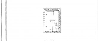
Data about each piece of land, as well as its location, are reflected in the general plan of the territory. It is a text document accompanied by an image of a map of the area with designated boundaries and neighboring objects.
In turn, the plan of the cadastral quarter contains aggregate information about the plots included in its composition, as well as their boundaries. This plan consists of text and graphic parts, which include:
- number, area, composition of the block and zones located on its territory;
- brief information about each site;
- a diagram indicating the location of the plan sheets;
- diagram, plans, drawings of sites.
A similar QC plan may be needed when changing the boundaries of plots, as well as when preparing and conducting land surveying. It can be obtained online. To do this you need:
- Go to the Rosreestr website.
- Open the tab “State class=”aligncenter” width=”1337″ height=”524″[/img]
- Select “Get cadastral plan of the territory.”
- Fill out the form and send a request.
- Get documents.
More about why mapping of land plots is necessary.
Registration
To get a unique set of numbers and find out all the necessary information about the district, you need to register your property.
For this you will need a package of documents:
- A completed application is a request to be included in the plan.
- Technical passport of real estate.
- Land survey plan of the facility.
A sample land survey plan can be found on the Internet.
There are also several additional documents proving ownership. More details can be found in Law No. 221.
The entered information about the site is presented in the following form:
- A registered cadastral passport with the possibility of obtaining an extract from it.
- A document containing an accounting plan (depicted graphically).
Purpose and procedure for assigning a site number
All land plots, the rights to which must be registered in the Unified State Register of Real Estate, are assigned individual cadastral numbers. The allotment number is usually understood as the serial number of the subsection in which information about the plot is recorded in the section of the state register of the district.
Numbers are assigned in accordance with the Rules approved by. This event is held only after:
- analysis and verification of documents submitted by the applicant on land surveying of a previously registered site;
- formation of newly formed plots.
To assign a number and register a plot, you must provide a boundary plan signed by a cadastral engineer. This can be done by contacting the Rosreestr office or submitting an application electronically on the official website. To do this you should:
- Visit the Rosreestr website.
- Open the “Individuals” tab.
- On the right, select “State cadastral registration”.
- Fill out the “Submit an application for the Civil Code” form and attach documents.
Briefly about the main thing
The cadastral number is a kind of address of a land plot on the territory of the Russian Federation.
Using the cadastral number it is possible to obtain almost all information about a land plot.
The cadastral block plan is used to formulate a boundary plan and helps in taking into account complex areas.
| A little more attention! Write in the comments what you think - is there an urgent need to record cadastral districts or is this just an unnecessary complication when recording land? |
Ratings 0
Read later
What is encrypted in the site number
A number in the cadastre is necessary for any legal action performed with land: inheritance, donation, lease, change of boundaries, and so on. Conventionally, it looks like this: ХХ:ХХ:ХХХХХХ:ХХХ. The first two digits indicate the number of the district, the third and fourth - the district, the next six - the quarters, and the last three - the number of the individual plot of land.
Operations to change the owner of real estate do not lead to a change in the cadastre number. The reason for its update is the change:
- boundaries of the site itself;
- other units of land;
- district and district data.
What does a cadastral number consist of and its interpretation?
Cadastral number is a combination that consists of a set of 12 digits or more. The first two digits are used to designate the cadastral district, then two more for the cadastral district. The remaining numbers (there may be six or more) identify the cadastral quarter, and the latter determine the land plot itself.
From this description we can conclude that the cadastral number of a plot provides complete information about its location on the territory of the Russian Federation.
An identifier can only be assigned after the site has been fully formed. Formation involves carrying out a land surveying procedure, a detailed description of the allotment, as well as drawing up and issuing documents confirming the right to own a particular land plot.
In some cases, the cadastre records areas that are located simultaneously in two or more districts, districts, or blocks. For such plots, a special concept of zero quarter is used
. In fact, it is written as zeros.
Quarter zero belongs to different districts at the same time. This may be interesting!
In the article at the following link, read about what to look for when choosing a plot of land.
How boundaries change
Changing boundaries is the introduction of additions and adjustments to official documents on a land plot in connection with a decrease or increase in its size. There are the following reasons for changing the boundaries of the quarter:
- Error. In this case, the work is carried out anew, the boundary line is updated and a new cadastral plan is drawn up.
- When the boundaries of towns and cities increase, the merging or division of plots occurs at the initiative of local governments or government agencies.
The procedure for changing the boundaries of a block is labor-intensive and time-consuming. Its registration is completed in the cadastral chamber.
The chamber's work on changing boundaries begins with the submission of an appropriate application.
Features of changing boundaries
In legal practice, there are many examples where erroneous information about real estate objects is presented. That is why we have to change boundaries by turning to governing bodies.
The Cadastral Chamber is the body responsible for changing the boundaries of register areas.
To be able to change the boundaries of the cadastral plot, you will have to write a statement requesting a revision. It is also necessary to indicate the basis for the argument.
After this, a package of documents is collected for re-measurement.
Cases of boundary changes are most often possible when the property is located in two cadastral blocks at the same time. Then the land plot is assigned a conditional number or zero. That is, in the line where six digits are located, zeros will be written.
Also, according to the All-Russian law, the land registration district automatically assigns zero numbers for land plots.
Previously, many agricultural plots with a zero number were called an object of general land use. Since the entry into force of the new law, these are multi-level unique land plots bordering two cadastral areas at once.
The requirements for changing the boundaries of plots are presented below:
- the shared object must not contain breaks (cuts) or unfilled areas;
- the boundary of the block must be closed, where all information about the site is accurately written;
- If an account number is removed from the register (due to demolition or another), then it is prohibited to use the same account number.
Previous information about real estate can be preserved when donating, selling or renting property.
Approximate deadlines for changing borders are given in Federal Law No. 221. Typically, this can last several months depending on the applicant's situation.
Cadastral registration of plots
All formed plots must be registered as real estate. It is during the registration procedure that the plot is assigned the number mentioned above.
If the land is not registered in the state cadastre, the owner will not be able to use it for its intended purpose or dispose of it.
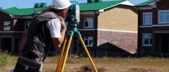
It should be noted that for state registration it is necessary to carry out land management work by inviting a cadastral engineer, who is included in. He will determine the boundaries of the site, draw up boundary and cadastral plans. On their basis, an allotment is formed, which, at the request of the owner, will be registered in the Unified State Register of Real Estate.
The quarter is also registered in the same way.
More about what cadastral registration of land plots is.
Everything remains the same, but you need to be vigilant
First of all, Rosreestr explained that land surveying from January 1, 2022 will be carried out on a voluntary basis, as before, and no one will take away a land plot, even if you did not have time to go through this procedure before December 31, 2021. The second sign of excitement was most likely caused by the fact that cadastral engineers decided to interpret the law on land plots and the new law on cadastral real estate in their own way
. The third sign is banal greed; cadastral engineers still wanted to make money from the legal illiteracy of the population.
Land surveying from January 1, 2022
Further, Rosreestr says that the new Federal Law-18 does not indicate anywhere about the timing of land surveying, which means that everything remains as before, but still, there is a certain recommendation on what needs to be done with the land plot after this period. An official representative of Rosreestr even pointed out the fact that Rosreestr does not speak anywhere on the website or in public statements about mandatory land surveying.
If your extract contains no information about actual land surveying, then you can easily go through this procedure after January 1, 2022, and the state will not apply sanctions to land owners.
Payment for CPT extract
The cost of an electronic extract of a cadastral plan of a territory in the form of an xml document is 350 rubles, excluding payment system fees. At the time of changing the article, payment can be made in several ways (they are available in the form for checking the execution of the request, when entering the payment code):
- QIWI Bank offers such opportunities as QIWI Wallet, QIWI payment terminals, payment cards of this payment system;
- Ural Bank for Reconstruction and Development;
- Payment through the government services portal;
- Bank Platinum;
- Bank "Tavrichesky" through payment by cards and from a mobile phone account.
After paying for the request, a letter will be sent to your mailbox stating that the application has been “Accepted for work”. After completing the application, Rosreestrom will receive a third letter, in which there will be a message that a document has been received during the processing of your application. To download it, follow the attached link and enter the access code provided in the letter.
Let's consider the 2 most popular methods of payment for extracting a cadastral land plot for a territory.
Qiwi wallet
When paying via QIWI wallet, follow the necessary instructions. Enter the wallet number, enter your phone number (the wallet number is linked to the phone number), full name, check the box that you agree with the terms of the offer and click on the “Next” button. An invoice will be issued in your Qiwi wallet. Go to the Qiwi website, enter your username and password. As a result, the “Pay” window of the QIWI wallet will display the invoice, which in our case is the amount of 350 rubles, the commission is 0 percent for the period of the QIWI “Payment for government services without commission” promotion.
Next, click the “Pay” button. Then you check the information in the summary information and select the “Confirm” button. An SMS message will be sent to your phone with a one-time code to confirm payment, by entering which you will again press the “Confirm” button and pay for the fulfillment of your request to receive an extract from Rosreestr. The next day, before 12:00, a message will be sent to your mailbox informing you that your application has been accepted for processing and indicating the planned completion date for processing your application.
State Services Portal
When paying through State Services, follow the necessary instructions. Enter your full name, select the region, enter the address and click the “Proceed to payment” button. Check the box that you agree with the terms of the offer and click on the “Next” button. In the next step, you must confirm the payment details, which indicate the details of the organization and the payment amount of 350 or 385 rubles (if ordering a bank receipt). We accept the terms of the offer and click on the “Yes, that’s right” button.
Cadastral value of the property
If you want to establish ownership of property, you are interested in cadastral valuation (cadastral value), you need a cadastral map of the Moscow region in 2021 - all data can be obtained via the Internet.
Cadastral valuation is a task that is solved by the cadastral chamber. Each region of Russia has its own calculation coefficients, determined by Rosreestr specialists. The cadastral value is determined taking into account factors such as:
- Material for the production of building walls;
- Market prices for real estate;
- Purpose and characteristics of the land;
- Environmental situation in the region;
- Date of construction of the building;
- Infrastructure features in the area in which the facility is located, etc.
It is necessary to maintain cadastral records competently and accurately. Please note that the market price of the object and its cadastral value, which affects the tax deduction and other settlement actions with the land, are different (on average by 25-30%).