The boundaries of a land plot can be established, as well as its area and coordinates determined using the land surveying procedure.
The concept was used back in the days of Kievan Rus; with the help of such work, the boundaries of the possessions of feudal lords were established.
Also, with the help of boundary work, areas allocated for various purposes were measured: arable land, forest and hayfield.
And now such work is the main part of land cadastral relations, allowing for more rational use of available land resources.
The essence of boundary work
Land surveying, in its essence, is an opportunity to officially establish the boundaries of a site in the form of turning points, determine the size of the plot, and also document this. In addition, having the results of such work in hand, it is possible to restore violated boundaries and protect the land plot from encroachment by other persons.
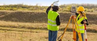
It is impossible to carry out the work . Determining the extreme points, even on a site of the correct shape, can only be done by a specialist from a licensed organization who has the necessary equipment at his disposal.
After all measurements have been taken and the results have been processed, the owner of the land is issued a boundary map , which will be needed in the future for transactions with property, as well as when dividing, forming or merging several land plots.
The document contains the following information :
- Scaled diagram of the measured territory;
- Exact coordinates of end points. On the ground they are marked with special milestones;
- Distance between milestones;
- Storage area.
Carrying out demarcation will allow you to assign the site its own cadastral number and enter it into the real estate register. Such actions are mandatory for completing a transaction for the sale of land, as well as for performing other significant actions with the land plot.
Pros and cons of land surveying
The main positive point in land surveying is that it is possible to carry out any legally significant transactions with a land plot. Also, thanks to this procedure, it is possible to avoid the occurrence of property disputes with the owners of adjacent plots and the administration.
Any cadastral work has its disadvantages. In the case of land surveying there are 3 of them:
- high costs, since in some cases land surveying is carried out by private companies;
- loss of time;
- Until the end of the land surveying procedure, it is impossible to carry out any transactions with the land.
However, these disadvantages at one time will not be as significant as legal costs or payment of property taxes. For example, in most regions of the country the tax is calculated from the cadastral value of the property. And if, in the owner’s opinion, the tax is too high, then a land survey can be carried out and the state assessment of the site can be challenged, thereby reducing the financial burden in the future.
In order not to overpay money and waste time, you can independently check online whether land surveying has been carried out. To do this, on the official website of Rosreestr you need to select the “Public cadastral map” section and enter the cadastral number of the plot in the search bar. In the results you can see the status of the site. If the site is “registered” and opposite the cadastral engineer there is the full name of the specialist, then land surveying has been carried out.
Difference between procedure and other concepts
Cadastral works
Land surveying allows you to establish the boundary points of an allotment by taking the necessary measurements.
To indicate the extreme points on the territory of land ownership, special signs are installed, the coordinates of which are used when drawing up a diagram of the allotment.
Then cadastral work is carried out, during which the information obtained is recorded.
Cadastral work is, in fact, part of the land surveying procedure , this is the difference between them.
During their implementation, the information obtained during measurement is structured, documentation on the land plot is studied, and measurements obtained using a satellite or special geodetic work are processed. Then a plan is drawn up, which is the final result of the cadastral work.
Based on such a document, a cadastre passport is subsequently issued.
Privatization
Determining the boundaries of an allotment during boundary work does not transfer the allotment to the category of private property of a particular citizen. To obtain ownership rights, it is necessary to carry out privatization.
Land surveying is only one of the stages in registering land ownership.
Moreover, it is necessary to take measurements and assign a cadastral number to the plot before initiating the privatization procedure , since such information must be present in the citizen’s application, as indicated by Art. 39.15 Land Code of the Russian Federation.
Geodesy of the territory
To carry out a set of procedures, united by the concept of “surveying,” engineers must first perform a series of actions that allow them to accurately determine the coordinates of the object under study .
Measurements carried out directly on the ground are called geodesy or geodetic work. One of the goals of such an event, in accordance with Article 10 of Federal Law No. 78-FZ, adopted on June 18, 2001, is to establish land ownership boundaries.
Without accurately establishing the extreme points and exploring the territory, it is impossible to obtain the information necessary for carrying out cadastral work. Therefore, geodetic survey is considered an important stage of the entire land surveying procedure.
Land management
Article 1 of the Federal Law No. 78 of the Federal Law, adopted on June 18, 2001, defines the essence of the concept of “land management”.
The procedure is a set of activities related to the study of land , which includes the determination of the boundary points of the allotment.
However, surveying is not part of the land development process .
The object of such work - a land plot - does not fall under the Law “On Land Use”, as it was before the entry into force of Federal Law No. 66-FZ, adopted on May 13, 2008. These concepts and meanings are not related to each other.
History of the development of land surveying in Russia
Let's dive into history a little. The development of land surveying in Rus' dates back to the 16th century, when the lands belonged to feudal lords, and their main features were recorded in the so-called scribe books. Subsequently, with the development of science and technology, the study of land surveying is gaining momentum, a land surveying school is created, which develops into the first higher education institution in land surveying - the Imperial Konstantinovsky Land Survey Institute (named after the grandson of Catherine II, Constantine). In 1918, the institute was renamed “Landing Institute of the People’s Commissariat of Education of the RSFSR”, and in 1930 it was divided into two higher educational institutions: geodetic (now the Moscow State University of Geodesy and Cartography) and the land management department (now the State University of Land Management). Today, there are hundreds of geodetic and land management universities throughout Russia, which indicates the demand for the profession.
Changes in Land Legislation
The mandatory carrying out of boundary work on land owned by the owner is not established by law .
Previously, it was necessary to take measurements on the site, but since 2007, such a procedure is carried out only at the request of the owners.
However, since 2021, there has been a tightening of land legislation, which has also affected the land surveying procedure. Preparations for it began back in 2012 with the approval of a special “Road Map” by Decree of the Government of the Russian Federation No. 2236-r.
Clause 21.4 states that entry into the Unified Register of land plots will not be carried out without first determining the boundaries and providing the relevant documentation. To consolidate the situation, Federal Law No. 447-FZ, approved on December 22, 2014, was put into effect.
who plan to take legal actions with their landholdings will have to take measurements . To sell, donate or inherit an object, you will have to worry about identifying the extreme points and entering information about them into the Unified State Register of Real Estate.
Such actions can be carried out not only before 2021, but also later. However, it is better to worry about land surveying in advance, since the procedure takes quite a long time, and the transaction will have to be postponed until its completion and the official entry of the property into the cadastre register.
The Boundary Setting Process
- Before surveying begins, information about the land allotment is studied in detail and systematized.
- After this, the surveyor goes to your site with the following purposes:
- determine the condition of the boundary signs;
- explore points of the boundary network;
- determine the exact boundaries of the plot.
- After this, a meeting of neighbors is held to agree on the established boundaries.
It is imperative to notify the owners of neighboring plots a month in advance.This task is performed by a cadastral engineer. His task is to find out information about neighbors in order to be able to contact them to notify them about the upcoming meeting. Sometimes information is even published in newspapers for these purposes (if contact cannot be reached by other means).
But this happens rarely and in most cases is pointless, since few people read these publications.
- Next, boundary signs are fixed, the size of the land and the supporting boundary network are determined, and data on the boundaries is obtained.
From all this, a land survey plan is drawn up, containing all the systematic information about the land survey:- result of a neighborhood meeting;
size of the plot, its boundaries;
- the presence of an easement;
- other information.
Read below for comments from land surveying experts:
Where to go?
As we found out, in most cases this is done by an organization that specializes in geodesy, and it is mandatory to have a license to conduct land surveying.
Reference! To be more specific, all actions are performed by a cadastral engineer; he most often works in such an organization. Sometimes there is a collaboration between the engineer and the surveying organization.
The main thing is to take your choice seriously. It happens that a cadastral engineer is not an excellent specialist , works for a long time and makes many mistakes.
This is precisely what can lead to disastrous consequences, in the form of the inability to register the plot of land for cadastral registration (most often due to incorrectly established boundaries).
Required documents
- Passport;
- cadastral passport;
- document confirming land ownership;
- other documentation regarding the site (for example, cadastral plan of the territory).
In terms of timing, everything is quite short if you choose a good organization or a private cadastral engineer. The deadline for completing the work is 2 weeks.
If we take into account the fact that it is necessary to hold a meeting with neighbors to agree on the boundaries of the site, warning them a month in advance, then in general it will take about 1.5 months.
Why is the work being carried out?
Determining the boundary lines of the territory belonging to a citizen is carried out not only in order to find out the area of the plot or register it with the cadastral registration authorities. Land surveying significantly expands the possibilities of using the territory , and also allows you to protect the rights of the owner.
Similar work is carried out to easily perform the following actions :
- Conclude a lease or sale agreement;
- Bequeath land by inheritance;
- Build legally buildings on the allotment;
- Resolve conflicts with neighbors in case of violation of boundary lines of property in court and during pre-trial settlement of the issue;
- To cut land, combine plots, or split the property into several parts.
The results of survey work are endowed with legal force .
If you have an ownership plan drawn up by specialists, you can easily prove that a particular territory belongs to a specific land ownership, and also protect yourself from the claims of unscrupulous neighbors.
Notes
- What documents are needed for land surveying (unspecified)
. - Federal Law of the Russian Federation of November 23, 2007 N 268-FZ “On amendments to certain legislative acts of the Russian Federation on the issue of registration in a simplified manner of the rights of heirs, as well as other citizens to land plots”
- List of works when buying and selling a land plot (Russian).
- Letter of the Real Estate Department of the Ministry of Economic Development of Russia No. D23-1290 dated April 12, 2010)
pros
Land tenure on which land surveying was carried out has a number of advantages over land ownership with unknown coordinates:
- Realtors and buyers prefer to enter into transactions with plot owners who have identified the extreme points in advance and completed the appropriate documentation. The presence of a boundary map and the entry of land ownership into the cadastral register allows one to subsequently avoid a number of difficulties associated with proving ownership ;
- sell demarcated property much faster , since you do not have to wait for the completion of boundary work and carry out the property registration procedure;
- When surveying, the list of actions that can be carried out with land ownership expands significantly.
If a number of conditions are met, the procedure can be carried out free of charge . The services of specialists are paid for from the local or federal budget.
Excerpt characterizing Land Survey
“Cossack,” she said threateningly. Most of the guests looked at the elders, not knowing how to take this trick. - Here I am! - said the countess. - Mother! what kind of cake will there be? - Natasha shouted now boldly and capriciously cheerfully, confident in advance that her prank would be well received. Sonya and fat Petya were hiding from laughter. “That’s why I asked,” Natasha whispered to her little brother and Pierre, whom she looked at again. “Ice cream, but they won’t give it to you,” said Marya Dmitrievna. Natasha saw that there was nothing to be afraid of, and therefore she was not afraid of Marya Dmitrievna. - Marya Dmitrievna? what ice cream! I don't like cream. - Carrot. - No, which one? Marya Dmitrievna, which one? – she almost screamed. - I want to know! Marya Dmitrievna and the Countess laughed, and all the guests followed them. Everyone laughed not at Marya Dmitrievna’s answer, but at the incomprehensible courage and dexterity of this girl, who knew how and dared to treat Marya Dmitrievna like that. Natasha fell behind only when she was told that there would be pineapple. Champagne was served before the ice cream. The music started playing again, the count kissed the countess, and the guests stood up and congratulated the countess, clinking glasses across the table with the count, the children, and each other. Waiters ran in again, chairs rattled, and in the same order, but with redder faces, the guests returned to the drawing room and the count’s office. The Boston tables were moved apart, the parties were drawn up, and the Count's guests settled in two living rooms, a sofa room and a library. The Count, fanning out his cards, could hardly resist the habit of an afternoon nap and laughed at everything. The youth, incited by the countess, gathered around the clavichord and harp. Julie was the first, at the request of everyone, to play a piece with variations on the harp and, together with other girls, began to ask Natasha and Nikolai, known for their musicality, to sing something. Natasha, who was addressed as a big girl, was apparently very proud of this, but at the same time she was timid. - What are we going to sing? – she asked. “The key,” answered Nikolai. - Well, let's hurry up. Boris, come here,” Natasha said. - Where is Sonya? She looked around and, seeing that her friend was not in the room, ran after her. Running into Sonya’s room and not finding her friend there, Natasha ran into the nursery - and Sonya was not there. Natasha realized that Sonya was in the corridor on the chest. The chest in the corridor was the place of sorrow for the younger female generation of the Rostov house. Indeed, Sonya in her airy pink dress, crushing it, lay face down on her nanny’s dirty striped feather bed, on the chest and, covering her face with her fingers, cried bitterly, shaking her bare shoulders. Natasha's face, animated, having had a birthday all day, suddenly changed: her eyes stopped, then her wide neck shuddered, the corners of her lips drooped.
Flaws
Despite all the advantages of the described procedure, land owners are in no hurry to order boundary work. This is due to the difficulties that the procedure entails.
The disadvantages of land surveying are:
- Long preparation for the procedure;
- The need for the presence of the owner when taking measurements and completing documentation: owners living in other regions cannot allocate enough time to carry out the work;
- The high cost of professional services, which are forced to turn to citizens who do not have the right to establish boundary lines for free or who do not trust specialists from the municipality;
- The need to obtain permission from the owners of nearby plots, which are impossible to find;
- Constant changes in the regulatory framework describing the procedure.
However, there is no point in delaying the determination of boundary lines.
Registration of a number of transactions, as well as the construction of objects on the territory without a boundary plan and in the absence of a mark on cadastral registration is considered illegal .
Relevance of the procedure if you have a passport
There is no mandatory procedure for land surveying yet.
Exceptions include cases where there is a need :
- registration of registration documents for the object;
- sale, lease, donation of an object;
- selection (delimitation) of an object from the array of neighboring territories;
- organization of capital construction at the site;
- combining several objects into one/dividing one object into several separate sections;
- enter into disputes over the ownership of objects.
Documentation
Before starting work, a specialist from a geodetic company may require you to provide a number of documents. Typically the list includes:
A document confirming the right to own the plot . It could be:
- Purchase agreement.
- Certificate of inheritance.
- Act of donation.
Technical documentation:
- Cadastre passport.
- Papers issued by BTI.
Identity card of the customer of services:
- For organizations - constituent papers.
- For citizens - Russian passport.
Some necessary information may be requested by the cadastral specialist directly from the Unified State Register or State Property Committee .
Registration in the MFC and on the State Services portal
For the convenience of citizens, a special multifunctional center has been developed, by contacting which you can receive services provided by government agencies. In this case, a person only needs to submit one application to the MFC, the data from which is then transferred to the Rosreestr service. The procedure usually takes no more than 10 days, provided that the person has collected all the necessary documentation.
The package of documents that will need to be provided to the specialist is listed above. After their transfer, the applicant is given a receipt indicating when it is necessary to re-visit the MFC and receive the completed papers.
Also, the State Services portal is now widely used. To use it, you need to go through the registration procedure, after which you can start working.
Coordination of the land plot boundary plan on the State Services portal
To find out whether it is possible to use the portal for land surveying purposes, you need to log into your personal account and clarify whether this service is provided by the competent authority via the Internet. It is worth noting that the list of services provided varies by region. For example, in the following cities it is impossible to obtain services via the Internet:
Lack of a way to receive services via the Internet
What stages does it include?
Carrying out boundary work includes several stages. The sequence of actions is reflected in the Instructions approved on April 8, 1996 by the Russian Federation Committee on Land Resources and Land Management.
from all companies that have received a license to carry out work to determine property boundary lines are required to follow the provisions of the act
Conclusion of an agreement
to take measurements independently, even if the necessary equipment is available, and the owner does not have the right . The determination of boundary lines is carried out only by a cadastral engineer who works in a licensed organization, or is provided to the citizen by the municipality.
Before carrying out, an agreement must be concluded between the customer of the services and the contractor. Before signing the agreement, you should definitely find out about the cost of the work, and also make sure that the employees who will perform them have qualification certificates.
At least 2 specialists from a geodetic company must participate in the process .
Land demarcation procedure
The actions that the land owner needs to perform are limited to the following list:
- Providing the documents requested by the specialist;
- Notifying neighbors about the procedure;
- Indication of the territory where land surveying is required;
- Payment of the cost of engineer services specified in the contract.
The remaining actions related to measurement and paperwork fall on the shoulders of the employees of the geodetic organization :
- Studying the documents confirming the right of ownership, as well as extracting the information about the allotment indicated in them;
- Development of a project for boundary work;
- Setting boundaries;
- Conducting surveys of the territory and installing special signs at the extreme points;
- Determination of land ownership area;
- Preparation of draft maps of the territory specified in the agreement.
Issuing a plan
Receiving a document with a diagram is the final result of the work.
It should contain not only a graphical layout of the object indicating the boundaries, but also a text part consisting of a table of measurements, acts of settlement of disputes and information necessary for registering land ownership in the cadastral register.
Entering information into the state cadastre
Registration of the information received in a special real estate register and registration of a cadastral passport for subsequent registration of property is the main purpose of conducting land surveying .
To enter an object into the state cadastre,
the owner is obliged to provide Rosreestr employees with the following papers :
- Boundary plan;
- Identity document;
- Completed and signed application.
When transferring documentation, a representative will need a power of attorney.
The period for registering land ownership is established by law and cannot exceed 10 days . After completing the procedure, the owner is provided with a cadastre passport containing data on the land plot.
Registration of ownership
With a cadastral passport, you can easily register land ownership as private property. attached to the papers on the ground before going to Rosreestr or MFC :
- Applicant's passport;
- Insurance certificate;
- Title paper on the memory;
- Receipt for payment of state duty.
Entering data into the Unified State Register takes 10 days . The applicant is then issued a certificate confirming that the property is his sole property.
Information in the cadastral passport
The cadastral passport is issued by employees of the state real estate cadastre and contains the main characteristics of the land plot.
The passport reflects the following information :
- who is the owner of the property;
- dimensions, location, area;
- category of land;
- special purpose;
- date of registration in Rosreestr;
- cadastral value;
- coordinates on the map;
- diagram and satellite view;
- presence of encumbrances (easements);
- data of title documents;
- boundary lines and turning points.
The specified information is contained in the new sample document . In the “old” CP only some points are included.
Information about the contents of the document is described in detail here.
Structurally, the CP consists of 5 sections :
- B1 (general data: cadastral number, owner, date of registration in the Unified State Register of Real Estate);
- B2 (graphic component: diagram (plan) of the facility, drawings of structures and buildings located on the land plot);
- B3 (information about encumbrances);
- B4 (borders indicating dimensions and angles);
- B5 (detailing of turning points within the boundaries of the object).
Price
Until March 1, 2021, regional authorities, through the introduction of local regulations, can establish a maximum threshold for the cost of boundary work. This is stated in Part 3 of Article 47 of Federal Law No. 221-FZ, approved on July 24, 2007.
After the expiration of the specified period, price regulation will not be carried out.
Each geodetic organization sets the amount of remuneration for each type of work independently .
The price
is determined taking into account many factors :
- Regional affiliation of land ownership;
- Established land use category;
- Allotment dimensions;
- Configuration;
- Distance from the city limits.
The national average price for land surveying is 2-15 thousand , depending on the specific set of required services and the above factors.
The technical diagram costs approximately 4 thousand , and the survey costs 1000 rubles .
Modern legal norms
Today, the Russian Federation has developed a clear legislative framework regulating land relations. At the federal level, issues are regulated by the Land Code of the Russian Federation and Federal Law No. 221 “On the State Real Estate Cadastre”.
This document clearly outlines the procedure for land surveying.
Significant amendments were made to the law in 2015, when the law on dacha amnesty came into force in the Russian Federation, which introduced changes to the conditions for the provision of land and new ways of registering rights to them.
Goals and types of procedure
What does land surveying provide? This procedure is carried out at the initiative of the owner or by court decision. The owner needs to carry out the work for the following reasons:
- registration of own rights to land;
- obtaining a land certificate for subsequent transactions with it;
- division of a plot or its combination with an adjacent one;
- land privatization;
- registration of territory for rent.
The procedure can be carried out by court order to resolve land disputes. In this case, the court appoints a land management examination.
Depending on the goals, the following types of land surveying are distinguished:
- Division of a plot is carried out by agreement of the owners who own the plot jointly. With this type of land surveying, one common territory is divided into equal shares to determine new boundaries for each.
This type of land surveying is necessary when buildings belonging to different owners are located on the same land. One of the types of dividing land survey is the allocation of part of the land from a common plot that remains indivisible.In this case, the boundaries of the original land ownership remain the same, and the allocated parts are registered in the cadastral register as separate objects.
- Clarification of boundaries is a type of land survey when the boundaries of previously registered land are expanded by the norm established by law. Such surveying is necessary for the subsequent unification or division of the site.
Registration of a land management file is necessary for citizens in the following cases:
- If a dispute arises with neighbors.
- When you receive a plot as an inheritance and a dispute arises with other heirs.
- During general development of the territory on which the land is located.
- If you plan to build an expensive building.
- If the site has a complex configuration.
Pros and cons of the procedure
When considering whether or not to carry out land surveying work on 2 plots of land, you should take into account the following positive aspects of the process:
- allows you to increase the size of the existing plot by 10%;
- protect the borders of the land from encroachment by unauthorized persons;
- establish clear boundaries of your own territory;
- resolve disputes with neighbors.
The disadvantages include the need to spend money on registration, the possibility of disputes and even litigation with neighbors, the impossibility of re-registering the land to another person until the survey work is completed.
How to make it for free
In 2021, a new pilot project is in effect, which allows residents of 13 regions to carry out free land surveying of their land holdings. The list includes regions of the Far North, as well as Crimea.
According to the law, land surveying can be carried out free of charge in the following cases:
- Rent or purchase of municipal unsurveyed land through an auction;
- The work covers a large area. During their course, each plot is separated separately.
In other situations, you will have to pay for the services of the geodetic company’s employees.
Geodetic surveying - what is it?
Modern construction is impossible without accurate terrain measurements. This is precisely what geodesy is for: marking out the site for design, setting coordinates and determining all heights. Geodesy is the science of “dividing” the earth.
In a technical sense, this is a science that provides branches of human activity , such as construction, cartography, mining, and cadastre with accurate location coordinates. With the help of this science we can obtain measurements on the surface of the earth, images on topographic plans and maps.
In this article we will pay attention to engineering geodesy, which serves to solve engineering problems. It arose relatively recently (in the 19th century) during the industrial revolution. Due to the increasing pace of construction of buildings and structures, there is a need to plot these objects on plans.
Engineering geodesy is a set of works aimed at studying the characteristics of the terrain, site, its natural features and building materials. The availability of water supply in the territory is also determined. This science is applied, since its main objectives are:
- (Engineering and geodetic surveys) of various areas and types of terrain to collect accurate characteristics.
- Engineering and geodetic design - changing the terrain, transforming the territory for carrying out all types of construction work.
- Applying the project to a given area. Breakdown of precise axes.
- Alignment of structures and construction equipment on site (all heights are taken into account, vertical markings are made.
- Measurements of deformations of structures.
The basis of a geodetic map is a grid of base points defined in a single system of geodetic coordinates. Such networks are divided into planned and high-altitude, which are built by the method of trigonometric leveling (determining excesses using a pair of graduated slats).
This process is called leveling - the creation of reference points of the high-altitude levels of the terrain. For areas with steep slopes, a theodolite is used for this task. Thanks to it, reference height points are also determined, but this device requires accurate measurements of the distances between 2 points.
Planned points are also found using a theodolite. In this case, directions, distances and angles between plan points are indicated. The network of planned reference points is determined by the triangulation method (a system of adjacent triangles with 1 base side and precisely measured angles).
Read where to order a plan for the planning organization of a land plot here.
Coordination with owners of neighboring plots
Carrying out boundary work on garden plots and individual housing construction is possible only after obtaining the consent of the owners of nearby plots . The intention should be notified in advance. It is best to use the services of the Russian Post and send a registered letter to each owner.
If conflicts arise in the future and it is stated that the neighbors were not notified, the delivery notice can be used as evidence that the owner is right.
Plots registered in SNT or a dacha cooperative can be surveyed only after the issuance of permission from the Chairman of the association.
After the test, a special act is drawn up recording the neighbors’ agreement with the results. Without it, the plan map received from the company is considered invalid, and ownership cannot be registered on its basis.
Grounds for determining territorial boundaries
As a rule, the establishment of boundaries occurs due to how they are actually used, but it is worth noting that the primary role in this case is played by existing acts:
- through which the right regarding the use of land is confirmed;
- geodetic data;
- information with a cadastral focus;
- acts that confirm the approval procedure with persons living in the neighborhood.
Stages of land surveying
After the land surveying plan is received, it is necessary to undergo additional verification procedures, which are carried out by the authorities of Rosnedvizhimost. To form a land plot, it is necessary to comply with the rules established in this direction in land legislation.
The Land Code stipulates how work with a boundary focus is carried out. These rules apply to territories in which property rights belong to the municipality, state, private individuals, and organizations.
When is the best time to do land surveying?
It is recommended to carry out land surveying if there are already disputes with neighbors over the boundaries between properties or if they are possible in the future.
Since previously, when identifying areas, precise measurements on the ground were not made, overlapping boundaries are possible. In this case, the one who is the first to accurately determine them receives an advantage.
Some areas turned out to be larger or smaller in reality than “on paper”. A larger size, if it was formed due to unused land, can be officially recorded.
If a new area is formed, precise fixation of its boundaries is mandatory. At the same time, it can be allocated from unused lands, as well as by dividing or merging existing ones.
Who provides land surveying services?
This type of service is provided by specialized companies that employ specialists - cadastral engineers and groups of surveyors. Such services are of a paid nature and are provided based on the application of the interested party and the documents provided by him for the site.
Application for land surveying.
Cadastral activities in general are regulated by special Federal Law No. 221-FZ of July 24, 2007. Article 29 of this law defines a cadastral engineer as an individual who is a member of the SRO of cadastral engineers and has appropriate education in the field of geodesy and cartography.
It is the cadastral engineer who forms the work plan on a specific land plot, and then the boundary work.
Important: these specialists must have the appropriate licenses and permits to conduct geodetic activities, otherwise the boundary plan of a plot of land issued by such an organization will be an invalid document.