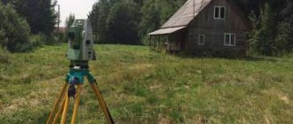
Land surveying is carried out according to certain rules. The law determines the procedure in accordance with which land surveying is carried out. We discussed in detail what land surveying is in the article: “Line surveying – what is it.” You can find out which organizations carry out surveying in your region from the catalog of contractors, and find out how much it costs to carry out surveying using a calculator for calculating prices for surveying. Now let’s look at whether a neighbor’s consent is needed to survey a land plot, how and with whom the boundaries of a land plot need to be coordinated in 2021, and what documents are signed and provided by neighbors of adjacent plots during surveying.
How to coordinate the boundaries of a land plot with neighbors according to the 2021 law
In order to understand how to correctly coordinate boundaries with neighbors during land surveying in 2021, let’s turn to the current legislation. Law 221-FZ “On Cadastral Activities” describes the procedure for land surveying from the point of view of the consent of the owners of adjacent plots. Coordination can occur in several ways:
- By convening a general meeting;
- on an individual basis.
The cadastral engineer decides how to coordinate land surveying. It is important to follow the approval procedure in terms of the established deadlines and the inclusion of the necessary information in the approval act. Otherwise, Rosreestr may have grounds to suspend cadastral registration. Article 39 of the cadastre law contains detailed explanations of how to coordinate the boundaries of a land plot with neighbors.
What to do if the land is not registered?
So, how to do land surveying if your neighbor’s land is not registered? In this case, you need to contact the chairman and look in the lists of gardening members to see who owns this land and by what right (about land surveying in a gardening partnership is written here).
It may very well be that the neighbor’s land is in perpetual use. The fact that it is not privatized does not mean that you cannot ask your neighbor’s opinion. After this, you need to agree with the user on the proposed boundaries.
Important: despite the fact that data on plots is easily entered into the cadastral register without the signatures of adjacent landowners, the latter, if they disagree, even in this case can file a lawsuit and explain why they do not agree.
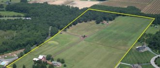
Who else is the boundary plan of the land plot coordinated with?
The boundary plan is coordinated not only with private owners of adjacent plots. Almost every plot of land in SNT and ONT borders on a common road or is adjacent to lands of a common territory. There are cases when the site is adjacent to the territory of an apartment building. Which neighbors should we take consent from when surveying a plot of land, or will it not be necessary at all? In fact, there are no difficulties here. Coordination of the location of the boundaries of a land plot is required by law if the adjacent plot belongs to the interested party by right:
- property;
- lifelong inheritable ownership;
- permanent (unlimited) use;
- rent.
If an adjacent land plot belongs by right of common shared ownership to several persons (a plot of an apartment building, the common territory of SNT, etc.), then the adjacent border to these lands will be agreed upon with the representative authorized for such approval (chairman of SNT or MKD).
Judicial practice of the Academy of Sciences "Pravozem"
Our lawyers have extensive experience in defending client interests in court on land surveying issues. For example:
- The administration was brought in as a defendant and proved that because of their employees, an error was made in the documents, as a result of which our client’s ownership was recognized.
- As a result of the survey, the overlap of boundaries was identified and the client’s boundaries were defended.
- They proved the mistake of duplicating cadastral numbers and brought everything into compliance.
When contacting us, the client will receive a free consultation on his problem, solutions and an analysis of the prospects for the proceedings. If possible, we will offer peaceful options for resolving the conflict.
When a neighbor may refuse to sign a land survey agreement
- Error while defining boundaries.
If an error occurred during boundary measurements or a neighbor does not agree with the new boundaries of the site, then he has the right to refuse to sign the document.
- Neighbor's absence from the meeting.
According to the law, information about a meeting must be notified no later than 1 month before the date of the meeting. If neighbors are unable to attend the meeting due to treatment or business travel, this may create difficulties in coordinating land surveying.
- The neighboring plot does not have an owner.
Such cases may occur when the owner has died and his heirs have not yet assumed their rights.
What to do if it is not possible to find the owners
If, during the preparation of the draft boundary plan, immediate neighbors could not be found, the owner of the site, in order to ensure that it is impossible to challenge the drawn up boundary plan, must strictly follow the requirements of legislative acts.
That is, in cases where the whereabouts of the neighbor are not known, it is necessary to comply with the existing procedure for notification in such cases - the original of the media in which the notification was published is attached to the boundary file as evidence of compliance with the required procedure .
How to survey a plot of land without the consent of neighbors
The cadastral engineer with whom you entered into an agreement to survey the land plot tells you what you need to do in order to coordinate the boundaries with your neighbors. If, for some reason, you cannot find a neighbor, then the land surveying procedure, alas, is delayed. After all, according to the law, all established deadlines must be met to notify interested parties in adjacent areas. For information on what to do if you cannot find the owner of a neighboring plot, read the article: “How to survey a plot of land without the consent of neighbors in 2021”
Cost and terms
The cost of a cadastral engineer's work is not regulated by the state. Therefore, prices vary depending on the specific company and region of circulation.
Approximate prices in 2021:
- Moscow and Moscow region - from 15,000 rubles;
- Leningrad region - from 10,000 rubles;
- other regions of the Russian Federation - from 5,000 rubles.
To clarify the cost, you must contact a specific organization. Costs also vary significantly between public and private professionals.
The timing of land surveying also varies significantly. When drawing up an agreement with a cadastral engineer, the document must contain the exact timing of the work.
Private organizations will carry out the procedure in 10–14 days. Due to employment, a government specialist can provide a service within 3–4 months.
Where to submit documents
Particular attention must be paid to the jurisdiction and jurisdiction of this application. Before filing a claim, you need to consider the following points:
- the price of the claim (if the price is more than 50,000 rubles, then the claim is filed in the district court, and if less, then in the world court);
- status of the parties (if at least one of the parties is an organization. Then the claim is sent to the arbitration court, if the dispute is exclusively between individuals, then to a court of general jurisdiction).
If the claim is filed improperly, the documents will be returned to the plaintiff with the appropriate determination. An error can significantly delay the review process.
Procedure
You can prepare the trial yourself or with the help of a representative. A good solution is to engage a land law lawyer.
Important! The process can be initiated within 3 years from the moment the citizen learned of a violation of his rights. Although it is possible to file a claim later, the defendant has the right to plead a violation of the statute of limitations. The court does not independently refuse consideration on this basis.
When drawing up a notarized power of attorney, a lawyer will represent the interests of the principal in court even in your absence. The cost of a notarized power of attorney in 2021 is on average 2,000 rubles. (depending on the subject of the Russian Federation).
The algorithm of actions to challenge land surveying includes:
- Collection of documents.
- Filing a claim.
- Payment of duty.
- Going to court.
- Trial.
- Obtaining a court decision.
- Contact Rosreestr.
Independent actions to challenge the land survey can lead to a negative result. It is necessary to note that the question contains many nuances.
Expert opinion
Stanislav Evseev
Lawyer. Experience 12 years. Specialization: civil, family, inheritance law.
In addition, one of the interested parties will be the cadastral engineer. Since challenging a land survey often reflects poorly on his rating (if he is found guilty), he will also hinder the rule of justice.
Therefore, when preparing for the process, it is advisable to choose a lawyer in land law. A specialist will explain to you the nuances of the situation and ways to avoid pitfalls.
You can get preliminary information on our website. The lawyer on duty is ready to help you at any time of the day.
Collection of documentation
A prerequisite for a trial is the presence of a serious evidence base. You need to prove to the judge that your rights have been violated. An unsubstantiated application will not be accepted for consideration.
You need to prepare for the process:
- civil passport of the owner of the plot;
- marriage document (if the land was acquired during the marriage);
- extract from the Unified State Register of Real Estate;
- title document;
- cadastral passport;
- fee payment receipt;
- land surveying;
- document on violations of the cadastral engineer;
- other data.
The exact list directly depends on the reasons for the challenge. If the cause is errors in documents, then it is necessary to conduct a forensic technical examination. Another cadastral expert will visit the disputed area and check for violations.
The situation is different if the cause of the dispute is a failure to reach agreement on boundaries between the co-owners. In this case, you will need to challenge the land survey and divide the property in court.
Additional witnesses can be brought in as evidence. Persons who know exactly how the borders are drawn are suitable in this capacity.
Example . Vitaly filed a petition in court to challenge the land survey. His neighbor on the dacha plot registered ownership, while seizing part of Vitaly’s plot. As evidence, the man presented a resolution on the allocation of land for use, and also brought in a witness. The chairman of the dacha cooperative explained that the fence was moved by the neighbor without permission. As a result, the area of Vitaly's plot decreased significantly. The court ordered an examination. The plaintiff's arguments were confirmed. The applicant's demands were satisfied in full.
Filing a claim
The application must be prepared in writing. It is advisable to compile it in printed form. The document should not contain emotional descriptions. Only facts and links to the law. Each specified fact must be documented.
The application must include the following information:
- name of the judicial authority (magistrate or district court, general jurisdiction or arbitration);
- applicant’s data (for individuals – full name, passport details and address; for legal entities – information from the Unified State Register of Legal Entities, information about the founders, information about the representative, details of the power of attorney);
- defendant's details;
- cost of claim;
- amount of state duty;
- title of the application;
- information about the rights to the site indicating the details of title documents;
- data on violation of rights;
- information about land surveying;
- evidence of rights to the allotment;
- reference to law;
- requirements (cancel the survey results, exclude information from the Unified State Register of Real Estate, establish the correct boundaries of the allotment);
- list of evidence;
- date and signature.
Violation of the submitted form may be a reason for refusal to consider the application. Since the general form of the claim is regulated by Art. 131 Code of Civil Procedure of the Russian Federation.
| No. | Additional requirements |
| 1 | On establishing the exact boundaries of the allotment |
| 2 | On the restoration of lost boundaries of the allotment |
| 3 | On eliminating obstacles during actual use |
| 4 | About eliminating errors in the Unified State Register of Real Estate |
| 5 | On the division of a plot in kind (allocation of a marital or inherited share) |
| 6 | On the inclusion of an allotment in the inheritance mass |
Sample statement of claim
Payment of duty
Cancellation of survey results applies to non-property claims. Therefore, the duty will be 300 rubles.
However, it can increase if there are multiple requirements. If you want to exclude information about land surveying from the Unified State Register and establish the correct land boundaries in one process, you will have to pay an additional 300 rubles. for each of the requirements.
In case of recovery of moral damages, lost profits and other compensation from the cadastral engineer, you will have to pay an additional fee, as for a property claim. It is calculated depending on the size of the requirements. The minimum amount will be 400 rubles, and the maximum amount will be 60,000 rubles.
It is advisable to raise the issue of compensation from the cadastral engineer in a separate claim. In this way, you can not only save on state fees, but also attach as evidence a court decision where his guilt was established.
Going to court
The right to go to court is vested in:
- owner;
- his representative;
- owner of the plot with the right of lifelong ownership;
- owner of the allotment with the right of use;
- tenant.
Consequences
The ideal option based on the results of going to court is to return the owner’s rights in full. However, the court does not always support the applicant's claims.
If problems arise, the owner must contact the Rosreestr office along with the court decision. At the request of the owner, specialists will make changes to the Unified State Register.
Important! If the plaintiff is the owner of a land plot on a property right (not on a proprietary right), then it is advisable to register the property as property.