Last modified: October 2021
The boundary plan of a land plot is one of the main documents defining property rights, the size and boundaries of land ownership. Any action to dispose of real estate requires the availability of executed documents. Depending on the type of property, the legislation establishes its own list of documentation. A land survey plan is required when preparing a cadastral passport and registering an allotment in the unified state register.
Obtaining a boundary plan requires compliance with a certain procedure and compliance with established design parameters.
What is a land boundary plan?
This is a special paper that contains all the information about the land plot.
This document allows you to enter information about the site into the state real estate database. A boundary plan is created based on the cadastral extract of the given site. The cadastral plan of the territory can also be used as a base. Typically such documents are stored in paper or electronic form. In it you can find absolutely all the information about the land plot that is required in order to register the plot with the state. The main information in this document is information about where the land plot is located and what its boundaries are. It is very difficult to register a site in accordance with all the rules. This process occurs quite often, not only when buying or selling a plot of land, but also during inheritance, donation and privatization. In addition, areas are often divided or combined. Absolutely every process must be included in the documents.
What is a land survey plan?
The land survey plan exists in two forms: on paper and in electronic form (certified by the electronic signature of the responsible employee and seal). It is produced on stapled A4 sheets with drawings attached.
- Data on the work performed.
- Basic information about the land.
- Required information for a new plot.
- Records of changes and clarification of the boundaries of the property.
- Identification of easements.
- Characteristics of individual parts.
- Final information from the engineer.
- The act of determining the boundaries of a site.
The information part in the form of a text document includes all information related to cadastral registration. The completeness of the submitted data is determined by the person authorized to take such actions.
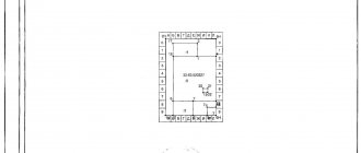
The graphic part contains the following sections:
- With a diagram of geodetic constructions.
- Location of land plots.
- Drawings of the charger and its individual parts.
- Outlines of nodal points establishing the boundaries of the allotment.
In the graphic section it is possible to visually determine and record on paper the specific location and features of the land and neighboring areas. The drawings and diagrams reflect additional information about the availability of access roads, passage, passage, and the method of gaining access to the land plots from public areas. Indication of access to the site is mandatory, even if it is through an easement.
Read: Easement - what is it in simple words?
You will have to pay for organizing land surveying work and drawing up a plan, since you can only receive the ordered document on a paid basis. The costs for the services provided are borne by the person who ordered their performance.
Download ORDER of the Ministry of Economic Development of the Russian Federation dated December 8, 2015 N 921 “ON APPROVAL OF THE FORM AND COMPOSITION OF INFORMATION OF THE BOUND PLAN, REQUIREMENTS FOR ITS PREPARATION” (Registered with the Ministry of Justice of the Russian Federation on January 20, 2016 N 40651) (384.5 KiB, 267 hits)
Appendix No. 2 Requirements for preparing a boundary plan (4.7 MiB, 298 hits)
Who makes the boundary plan?
The plan is drawn up by a cadastral engineer, who must have the appropriate education, as well as a document that will allow him to carry out such work. On June 1, 2016, a law was introduced stating that an engineer must be a member of the SRO of cadastral engineers.
The engineers working in our company have all the necessary documents. You can view them in the Our Certificates section.
One of the jobs of a cadastral engineer is land surveying: the boundaries of the land plot are precisely determined, they are agreed upon with the owner, and after determination and approval, the boundaries are fixed. As a result of this work, a ready-made document appears that will allow the land to be registered in the cadastral register.
When is a boundary plan necessary?
Such a document is required when you are going to carry out any manipulations with the site. Documents are required for absolutely any changes. For example, if a new site has arisen, if the boundaries of the site have changed or there is a need to clarify them. If your site is not registered, or you have made any changes and have not secured them, then you need to order the execution of such a plan.
Naturally, not everyone understands why all the data about changes should be entered into the registry. Recently, a law has appeared stating that you can simply make rights to a plot of land and not carry out land surveying. However, despite the fact that making such a plan is quite long and expensive, it makes sense. In this section you will learn why such a plan is needed.
Boundary plan of the land plot
Documentation
What to do after receiving the boundary plan? This document is necessary to register the allotment for cadastral registration in Rosreestr.
In addition to the boundary plan, the following documents will be required:
- Confirmation of ownership rights to a land plot (PL) - certificates of ownership, inheritance of an allotment, a judicial act, etc.;
- If the use of the plot is on a leasehold basis, the following is required: a document agreeing on the registration procedure with the Ministry of Property, as well as written permission from other tenants of the plot;
- The original power of attorney, if another person will handle the execution;
- Paid by state fee when registering a newly formed plot.
Documents that need to be collected to draw up a boundary plan
The types of plans can be completely different; they are drawn up using different documents. It is impossible to write absolutely all the documents that will be required when drawing up different types of plans, since various circumstances arise. Here is a list of general documents that you will need in any case.
- You must take with you documents that indicate that you have rights to this site, as well as documents for the house.
- Documents that certify the owner of this plot. If necessary, you will also need a power of attorney for the representative.
- If there are any buildings on the site, then you will need a technical passport.
- A cadastral extract for a land plot, or a cadastral plan of the territory.
We help you obtain a cadastral extract and other cadastral documents.
When contacting a cadastral engineer, you need to provide him with absolutely the entire list of necessary documents (originals or notarized copies). This is done in order to avoid fraud. At the moment, the boundary plan must be created in electronic form. Therefore, the documents you provide must also be in electronic form; they can be scanned. Be sure to scan the original. There are some rules for these documents. The scale of the document must be one to one in its original size. The color of the document must be 24 bits, the document resolution must be 250-450dpi. The document must be in PDF format. If your document has several pages, then you need to create one file for all of them. Copies of all documents are attached to the plan. If you do not provide at least one document, or violate any rules for creating them, then you may be refused to register the site.
Procedure for registering a boundary plan in Rosreestr
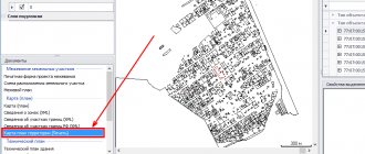
Having collected all the necessary papers necessary to register the boundary plan, you can order the cadastral engineer to generate a document in XML format for subsequent submission to Rosreestr. Service Geo engineers can independently submit a cadastral (landmark) plan to Rosreestr by transmitting data with an electronic digital signature.
Registration procedure
- Payment of duty.
Before registering a boundary plan, you need to pay a state fee of 350 rubles.
- Submission of documents
Submit all documentation to an authorized employee to forward them to Rosreestr in the My Documents (MFC) departments. In return, a receipt will be issued confirming receipt of the registration kit.
- Registering a storage unit
If there are no discrepancies in the submitted documentation, the land plot will be registered with Rosreestr and assigned a conditional (cadastral) number. If it turns out that it is necessary to make changes to the boundary plan, registration can last from 2 months to six months.
On the established date, you will need to come for documents for the lease and an extract from the Federal State Budgetary Institution Rosreestr. You need to take your original passport and previously issued receipt with you.
It is impossible to carry out land surveying on your own. At all stages, the participation of a cadastral engineer will be required. You can get a free consultation from our engineers by calling +7 (495) 720-68-84.
What types of boundary plans are there?
Land survey plan
There are several types of boundary plans. There are three main subgroups of boundary plans:
- To form a plot of land. This is both a combination and division of land plots. You can combine two or more areas that have an adjacent border, but are divided into two or more parts. Also, such documents will be needed when allocating land plots, when distributing plots, as well as when forming a plot from different lands.
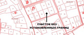
- A boundary plan can be created in order to clarify the boundaries of a land plot.
- To correct cadastral errors.
When forming all these plans, there are many nuances that can only be entrusted to professionals.
Requirements for the boundary plan
The requirement for how a boundary plan should be drawn up and how it should be executed is contained in several federal laws. In order to know exactly how to draw up a land plot plan, you need to study the following documents:
- No. 136-FZ “Land Code of the Russian Federation”. This is the main document. Here you can find absolutely all the information about how land relations work and what they consist of.
- No. 221-FZ “On the State Real Estate Cadastre”. It tells about the cadastre, what it consists of and how to maintain a land cadastre.
- No. 412 “On approval of the form of the boundary plan and requirements for its preparation, an approximate form of notice of a meeting to agree on the location of the boundaries of land plots.” This document will tell you how to properly prepare an interplane, what the requirements will be for it, and what you will need for this. If you are planning to prepare such a plan, then you need this document.
How long will it take to prepare the boundary plan?
It is impossible to say the exact timing of drawing up the boundary plan. They depend on a variety of cases. Time determines many different nuances. For example, when ordering a boundary plan, you may not know some information, so it will take time to figure it out, there may also be problems with rights, etc. Typically, drawing up a boundary plan takes from 2 weeks to 1 month. The contract is concluded in about one day, and all the documentation you provided is checked in the same amount of time. It usually takes from 3 days to 2 weeks to receive a cadastral extract and CPT. If field work is needed, it will take approximately one day. Then all measurements are processed and approval acts are prepared. This usually takes about 2 days.
The boundaries of the land plot are agreed upon from 5 days to a month. But this is only in cases where it is required. The boundary plan is finally formed in about 2 days. The timing may vary, since sometimes a specialist visit is not required. Sometimes you don't need to agree on boundaries. If absolutely all the documents and measurements are collected, then it may take only a few days to prepare the plan. Sometimes just one day.
If you need to know the exact timing, as well as the cost of preparing a boundary plan, then you should contact our consultant. He will provide you with all the necessary information.
Of course, all these numbers are inaccurate, you just have to rely on them. No one can give you a guarantee on the accuracy of the deadline, since everything is very individual. If there are any disagreements, the formation of the plan may be very delayed.
In the worst case scenario, there may even be a lawsuit. Therefore, before contacting a specialist, you need to collect the entire list of documents and make sure that no problems arise.
Purpose of the document
Without a boundary plan, it is impossible to properly register the site and register it according to the cadastre.
However, the list of what this document is needed for is much wider:
- Reorganization of an allotment (allocation and division of area with the formation of two or more plots).
- Consolidation of adjacent lands into a single plot.
- Annexation of additional territories bordering on any side of the allotment.
- Installation of engineering communications.
- Coordination of the construction process, obtaining permits for individual housing construction.
Resolution of any issues and controversial situations relating to land requires the execution of a document:
- buying or selling real estate;
- conclusion of lease agreements;
- donation;
- exchange;
- registration of the owner's rights to the land plot (the territory in question);
- consolidation, allocation and division of land.
If a transaction is carried out without land surveying, interested parties may challenge it and declare it illegal.
Thus, the purpose of a boundary plan is to record the size and characteristics of the right to an existing land plot and formalize any changes affecting the territory in question.
The procedure for preparing a boundary plan for a land plot
We will walk you through the standard plan preparation process.
- First comes the preparatory stage. You need to find out the purpose for which this work is being carried out, an agreement is formed with the customer, and all documents are studied. This is a very important stage. Thanks to it, you can immediately find all the errors that may be in the documents, correct them, and discuss all the nuances. If errors are not found at this stage, then later they can greatly interfere with the preparation of the plan and slow down all the work. It is at this stage that documents are prepared that are not enough to prepare a boundary plan.
- Then field work takes place. Sometimes this is not necessary. But if there is no data about the site in the register, then it will be necessary to take measurements. They need to be carried out as accurately as possible so that later the register contains absolutely accurate dimensions of the site. If you take incorrect measurements, this can greatly hinder you in the future. Not only the boundaries of fences are measured, but also the boundaries of natural objects, for example, rivers or forests.
- Then all the information is processed, the final plan is prepared, which is later transferred to the registry along with the accompanying documents about the site. This can be done by both the customer and his authorized person.
After successfully completing all stages, you will be issued a cadastral passport.
Receipt procedure
The document is prepared by a specialized organization that has the right to carry out land management work, including land surveying. For the preparation of the document by the organization where the ordered services are received, a fee is charged according to the internal tariff.
Read more: When is an examination of land management documentation needed?
To draw up a land surveying plan, submit a corresponding application and pay for the work. The initiator of action can only be a person who has submitted sufficient documents confirming the rights to the object specified in the application or is directly interested in it.
Drawing up a plan requires mandatory boundary work and is carried out in the following sequence:
- Receiving and processing information relating to the land plot.
- Informing interested parties in the upcoming land survey (individuals and legal entities owning adjacent plots).
- Identification and coordination of the size and boundaries of the site.
- Carrying out geodetic work with surveying.
- Compilation and analysis of the obtained data by a cadastral specialist.
- Drawing up a land surveying plan, which is then submitted for verification and registration to the body that controls the cadastral registration process.
- Registration of a cadastral passport. After receiving approval and entering information into a single database, a cadastral extract is prepared that determines the geographical coordinates of the land.
- The boundary plan is recognized as valid if it is certified by the seal and signature of the cadastral engineer.
The hand-delivered boundary plan includes, as one of the annexes, an act of agreeing on the location of the site with other interested parties. It is attached on the back in the section with graphic information about the site.
Required papers
The main conditions for obtaining a land survey plan are: carrying out the survey procedure and confirming legal rights to this land plot.
The list of documents required for drawing up a boundary plan includes:
- Application from the person who has the rights to the land in question (filled out according to the sample).
- Certificate of registration of ownership.
- A document establishing the right to own land (certificate of inheritance, resolution of a judicial body, other official bodies ordering the allocation of a plot in favor of a specific person, etc.)
- Personal document proving the identity of the applicant. For legal entities, it is necessary to submit constituent documents.
- Technical documentation of the BTI, if a building is being erected on the land.
- Cadastral documents (extract and territory plan).
Download a sample application for land surveying work (28.0 KiB, 288 hits)
Each land registration case is unique. It is possible that the land management company will request additional paperwork to establish the legal boundaries, coordinates and size of the site.
Often, in the process of determining the boundaries of adjacent plots, disputes arise between neighbors. If it is not possible to agree on boundaries at the stage of surveying and drawing up a plan, the owner goes to court to resolve the dispute.
Download a sample statement of claim to establish the boundaries of a land plot (12.9 KiB, 268 hits)
Timing and cost
Operations with land and registration of documents for it differ in the duration of the process. Ordering the services of cadastral engineers and drawing up a document based on collected and analyzed information requires certain costs. For this reason, if you intend to make transactions with this property in the future, you must be prepared for certain expenses of time and money.
There are no uniform prices for cadastral services due to the impossibility of bringing various individual characteristics under unified rules. However, each region has its own average tariffs applied by local specialized organizations.
The cost of services is affected by:
- Features of the location of the site and its geometry.
- Belonging to a certain category of land.
- The price range that has developed in a specific constituent entity of the Russian Federation.
On average, obtaining land surveying and planning services in the Moscow region will cost from 10 to 30 thousand rubles, and in the suburbs of St. Petersburg the prices are lower - approximately 7-8 thousand rubles. In more remote areas of the country, costs will range from 5 thousand rubles.
The difficulty in determining exact costs is due to the fact that a separate boundary plan is rarely ordered. Usually, its production is accompanied by an order for services for measurements, approval and registration of a cadastral passport.
The process of approval, data collection, taking measurements and analyzing the information received requires a certain amount of time.
The following information will allow you to plan further work on the preparation of land documentation:
- applying for the required paper – 1 day;
- consideration of the application and verification of information received from the customer – 1 day;
- performing land surveying work – 1 day;
- processing of received information and coordination with interested parties - at least 2 days (in complex situations - several weeks);
- in the absence of a common opinion and consent of the owners of adjacent plots, the consideration of disputes is transferred to the court, and the duration of this stage reaches up to several months;
- The final compilation of data and the compilation period in days takes no more than 2x.
Due to the impossibility of taking into account all the features of land surveying, the exact time for production is not regulated by law, and the validity period is limited only by the occurrence of new circumstances in which changes are planned to be made to the characteristics of the object.
Cost of the boundary plan
The price depends on many factors, each of which increases or decreases the cost of the work.
Our company has an average pricing policy. We are confident that good, high-quality work will not be cheap. When drawing up the plan, very expensive equipment is used, the engineers are very well educated. In order to properly draw up a good plan, you need specialized software, which is very expensive and installed on expensive equipment. Workers who perform these jobs are subject to both personal and criminal liability. Because of all this, such work cannot be very cheap.
Even if you decide that our company’s pricing policy does not suit you, we do not recommend turning to very inexpensive specialists. This could be a huge mistake. To ensure that your plan is accurately accepted by a government agency and that no problems arise, you should only contact good specialists who have extensive experience in drawing up such plans.
We will do all the work for you, prepare everything you need. Our engineers have been working on such plans for a very long time.
Attention!
The information on the site is more for informational purposes and provides basic knowledge on your problem.
Each individual case is individual, so you can check any information with our on-duty legal consultants 24/7 and free of charge.