At the same time, the bill “On Amendments to Certain Legislative Acts of the Russian Federation on the Issue of Registration of Citizens’ Rights to Certain Real Estate Objects in a Simplified Procedure” was adopted.
A large number of land owners have already taken advantage of the “dacha amnesty,” as these changes were popularly called, but the need still remains. Therefore, this law has been extended more than once. The latest changes to the law were made on February 28, 2015 , it was then that the “dacha amnesty” was extended for another 3 years.
How to register the addition of a land plot in accordance with the Land Code
The Land Code does not contain such a concept - the addition of a land plot. Redistribution of land plots is commonly called redistribution. According to the general rules for the formation of land plots (Article 11.2 of the Land Code), there are several types of formation of new land plots:
- Allocation;
- An association;
- Redistribution;
- Chapter.
In the article we will not consider each of these types in detail, but we will talk in more detail about redistribution, or more precisely about how the addition of a land plot in 2021 occurs due to the area of adjacent lands, and how the size of a land plot can be legally increased.
Increasing land area: how much is this possible?
Owning a plot of land for a certain time, due to various circumstances, the area of the plot increases, that is, a process of “squatting” occurs near the lying territories. If this does not cause any claims from neighbors, or this is a non-residential area, and also not state property (national park, nature reserve), then it is possible to expand your possessions at the legal level.
For each case, the amount of added land is calculated separately, but not more than 10% of the size of the main plot . Let's look at how many acres can be cut using an example.
For example, if the plot is 6 acres, then we get another 0.6 acres. To determine and secure any boundaries of the site, you should contact the cadastral chamber, where they will survey the land.
There are several nuances that can complicate the process of increasing the site.
Firstly , the law stipulates that a free increase is possible only if the “additional meters” do not exceed the specified minimum area. The standard size is 6 acres, so you will have to pay extra for each “extra” hundred.
Secondly , a cadastral engineer cannot just increase the size of a plot.
This requires strong justification. At the same time, he must refer to information from the original documents.
If exact data is not available, then the boundaries are established according to existing (15 or more years) boundaries.
New law on land acquisition 2021
Laws in the field of land management and cadastre have undergone active changes in recent years. The new law on the addition of land plots, effective in 2021, is a whole layer of rules affecting the formation of land plots. At the beginning of 2019, Federal Law 217 on horticulture came into force, changing the basic concepts and definitions of summer cottages. On June 17, 2021, a new law 150-FZ was adopted, amending the laws on cadastral activities and real estate registration (218-FZ and 221-FZ). The changes concern complex cadastral works: the procedure for carrying them out is simplified, while it remains possible to increase the land plot up to 10% of its total area if, during the complex cadastral works, it turns out that in fact the plot is larger than on paper. The State Duma is also considering a number of amendments to simplify the procedure for registering land plots and buildings (the dacha amnesty will be extended until 2022).
Only the owner can add additional acres to his plot. Tenants of land plots, as well as persons who own land plots for free use, do not have this opportunity.
Sanctions for illegal land seizure
Cases of illegal seizure of land are established by Art. 7.1 Code of Administrative Offences. If fraudulent aspects are identified, the case may fall under the criminal code. With this option, the offense faces much more serious consequences than just a fine and seizure of the site. In the absence of fraudulent activity, the violator will most likely pay a fine. Its size depends on several factors:
- whether the plot is registered in the cadastral register;
- What is the estimated value of this plot of land?
Is it worth the risk?
The main task is to simplify the procedure for registering a house under the dacha amnesty with the possibility of adjusting land plots . The number of documents is reduced, and the opportunity to simultaneously submit documents for cadastral registration and state registration of rights is provided.
At the same time as these advantages, a number of loopholes have emerged that facilitate frankly illegal actions. For example, the law in no way protects those citizens whose plots were cut in connection with the dacha amnesty for others.
To avoid sticky situations, it is still recommended to contact specialists. This will save time, money and nerves.
How to legalize the addition of a plot of land for free
Attaching a land plot to the main one is an increase in the size of the land plot at the expense of adjacent lands. Not every owner is aware that he can legally register an addition to a land plot and receive additional land ownership free of charge. How to legalize the cutting of a plot of land for free, you ask? In fact, the law allows the increase of a land plot by no more than 10% of its area at the expense of municipal lands. But there are also caveats. It is important that the land is not privately owned and under encumbrances; in addition, local authorities have the right to legally establish additional restrictions on the size of the addition of land plots. In any case, the registration of the addition of a land plot should be legalized by submitting the necessary documents to the Rosreestr authorities.
How to enlarge the area?
Each type of property has its own procedure for registering rights. The only thing that remains unchanged and established by law is the list of documents. Therefore, the requirement of registration authorities to provide any additional materials is illegal.
To register ownership of the extra acres, you need to contact the territorial body of the Federal Registration Service.
Documents that need to be provided:
- Identity card of the owner or his attorney;
- Document confirming ownership.
The dacha amnesty significantly expanded the list of such documents. Now these include extracts from business books, certificates, acts and any papers that previously had legal force.
- Receipt for payment of state duties (cost can vary from 150 – 200 rubles);
- State registration of property rights.
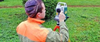
A separate item is the cadastral plan . When obtaining a plan for a land plot, some complications may arise. The fact is that in the early analogues of the cadastral plan, relatively accurate data was entered: location, approximate number of acres. Now this results in the need for land surveying.
This is a labor-intensive and lengthy procedure, the duration of which varies in each office. Sometimes surveying takes up to six months.
After clarifying the boundaries (landmarking), you can move on to expanding your territories. There are several reasons for this:
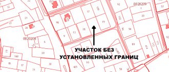
- Lack of information about the land plot in the state cadastre;
- Neither the location nor the size of the plot have been determined, although it has been registered;
- Availability of any corrections in the cadastre.
And here you can find out where to get the dacha amnesty declaration form.
Deadlines for reviewing documentation:
Within two weeks from the moment the documents are received by the authorized body, the issue of assigning owner status is resolved. Refusal is possible if there is a corresponding federal law.
If the answer is positive, you should then contact the registration service to claim ownership of the property. To do this, you need the same package of documents as at the previous stage.
After submitting the documents, the registration procedure itself will take about a month. If a refusal is given, the reason is given, and the applicant can also appeal this decision in court.
What documents are needed to approximate a plot of land?
The desire to increase the land plot is not enough; action must be taken. To begin with, find out from the local authorities the nuances of restrictions on the size of the addition of a plot of land in your area, and what documents are needed for the addition of a plot of land in your municipality.
The main documents are:
- Application for cutting (redistribution)
- Agreement
- Extract from the Unified State Register of Real Estate
- Land surveying project or site layout diagram
- Title documents for land.
How do extra acres threaten the owner after land surveying?
First, you need to figure out why this mess happened:
- cadastral error, the culprit of which is a cadastral engineer who made an inaccuracy when drawing up a plan or taking measurements,
- imposition of plot boundaries as a result of errors in measurements carried out with low accuracy, up to two thousand and eight,
- conscious expansion of one’s territory beyond the adjacent network.
A citizen who has seized a neighboring territory, according to the law, faces a significant fine for such annexation.
Attention! If a municipal territory is seized with a “general economic” purpose, the fine will range from five hundred rubles to one thousand. If it is a forest or water area, then how much such an offense costs can be found out from regulatory documents, but the amount will increase many times over.
Further, in any case, it is necessary to somehow resolve the issue of legalizing borders. If the neighbor does not mind in the matter of private property, the problem can be resolved peacefully.
And with municipal land, the issue is resolved by contacting the local administration with an application for transfer for free use. Such a change has been provided for by law since March 1, two thousand and fifteen.
Time limits for consideration of an application for subdivision of a land plot
The Land Code (Article 39.29) establishes the following deadlines for consideration of an application for the addition of a land plot:
- total period 30 working days
- extension of the period to 45 working days (if additional documents are needed)
- The deadline for returning an incomplete set of documents is 10 days .
After the application is accepted, an agreement is concluded that the municipality is not against increasing your land.
Redemption of land
If it turns out that part of the territory of an adjacent landholding has been “grabbed”, it is necessary to urgently solve the problem that has arisen, without putting it on the back burner.
In 2020, the legislator allows changing the boundaries of a land plot, whether it is a SNT with the purpose of gardening, or the lands of settlements - private plots or private housing construction, using completely “cowless” methods. One of them could be the purchase of “extra” acres.
To do this, you need to clarify who the owner of the adjacent area is. This could be a municipality or a state. In addition, the lands should not have the status of “public land” or be withdrawn from circulation.
Increasing the area of land - is it free or for money?
There is an opinion that increasing the land plot can be done completely free of charge, but this is not so. It is only possible to obtain the adjacent lands for free, that is, they do not need to be purchased from the state, and the very registration of the new formation in the form of an enlarged land plot after the addition is a procedure that requires monetary costs. Indeed, in order to document newly created possessions, it is necessary to prepare a boundary plan. To do this, we enter into an agreement with a cadastral engineer, naturally on a paid basis. The newly created site must be coordinated and a ready package of documents must be submitted for registration to the MFC. All this time and money, but as a result you will receive a legally registered plot with an increased area.
You can find out the cost of cadastral works using a free service on the website - an online cadastral work calculator.
You can also find a catalog of companies in your region that provide cadastre services on the website.
Clarification of the area of the site
Clarification of boundaries is a legal procedure for changing an allotment by adding a new space.
Attention! In fact, these works are carried out by a cadastral engineer and require contacting a geodetic organization with a corresponding application. To do this, it is necessary to carry out land surveying again. When performing such work again, the owner must justify such a procedure and provide the old survey file.
Next, draw up a border approval act signed by all adjacent neighbors. And the registration process is completed by the subsequent registration of new information in Rosreestr.
When state or municipal lands are annexed, the new owner is responsible for:
- for the redemption of the annexed part of the allotment,
- additional payment of land tax,
- operation in accordance with the type of permitted use of the land.
Instead of a conclusion, or Putin’s opinion on the addition of a plot of land
Vladimir Putin allowed Russians to register surplus land. This benefits both the state and the ordinary citizen. By signing 150-FZ dated June 17, 2019 (the law came into force on September 16, 2019), the president thereby expressed his opinion on the appropriation of land plots and confirmed the need to simplify cadastral work, which, according to the deputy head of the cadastral chamber, Marina Semenova, will have a positive impact on land owners. The registered plots will now officially be the property of citizens - which will increase revenues to the treasury through land taxes, and citizens, in turn, will be able to own plots not only in kind, but also legally.
What to do when reducing area
Reducing the area of land is possible in two cases :
- When correcting a cadastral error. Moreover, according to Order of the Ministry of Economic Development No. 943 of 2015, the initiative to correct a cadastral error can come not only from the owner of the plot, but also from Rosreestr.
- When a claim arises from neighbors who carried out land surveying, according to the results of which the border of their site runs along an adjacent plot.
In any of these cases, the site owner has 2 ways to solve the problem:
- Agree with the reduction of land and sign the deed of approval of boundaries.
- Do not agree with the reduction and order clarification of the boundaries of the land plot.
If the clarification procedure does not give the desired result, you can file a claim in a court of general jurisdiction , which will appoint a judicial land management examination.