The presence of a land plot presupposes the availability of the necessary technical and official documentation, where the documents are evidence of who is the owner of the land and what legal parameters are provided. A detailed cadastral plan of the territory, a sample of which is presented in the new detailed extract from the Unified State Register of Real Estate, reveals all the necessary data about the property you are interested in in full. Order an extract from the Unified State Register of Real Estate with the cadastral plan of the territory and look at sample documents here.
What is included in the cadastral plan of the territory
A modern example of a cadastral plan of a territory includes several working sections of information. A full document from the cadastre consists of the following sections:
- General information on real estate. The body that carries out the registration of the site; territory plan number, area of the territory, presence of encumbrances, title characteristics, information about neighboring and bordering areas.
- Schematic representation of the territory of the land plot.
- Data on parts of the allotment.
- Indication of the boundaries of remote areas.
Starting from 2021, the cadastral plan of the territory, as a sample, is presented only in the expanded format of a new document - an extract from Rosreestr.
What is it for?
- As mentioned above, this is a necessary document for the preparation of boundary and technical plans and a diagram of the location of the land plot on the cadastral plan. It provides cadastral engineers with comprehensive information about cadastral boundaries adjacent to the property being registered. This allows you to unambiguously determine the location of the property under study and the presence of overlays or other cadastral errors.
- It is also important for designers. For the design of buildings and linear structures (roads, gas pipelines, etc.). It is important to know how to arrange so that the minimum number of registered land plots is affected by the protection zones of future objects.
Accordingly, the “shelf life” of this document is very short - after all, even immediately after its receipt, some object in a given cadastral quarter may “stand up” on the cadastre. And the CBT received will no longer be fully relevant.
How to order an extract containing a cadastral plan of the territory
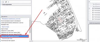
In order to order an extract for a land plot containing a cadastral plan of the territory, we suggest using our public cadastral map service. To search for information and receive an electronic or paper version of the document, you will need to enter a known plot code, the so-called cadastral number. If you find it difficult or don’t know what the code of the land plot is, just enter the physical address of the object of right known to you.
Cadastral plan of the territory: sample The Roskadastre database operates in an updated mode, and our service will provide you with only current information on real estate. Certificates with a seal, including the digital signature of Roskadastre, are recognized as an official working document. With this information, you can carry out land surveying, challenge the cadastral value, clarify the details of your property rights, and dispute with neighbors over the territorial affiliation of the boundaries of the site.
Cadastral plan: its definition and main provisions
A cadastral plan of a territory is a document that contains all the information about a specific land plot (PL). It is compiled on the basis of a map of the area and indicates the boundaries of the cadastral quarter (CC).
Important ! Without KPT it is impossible to register real estate as a property.
The registration and issuance of the cadastral plan is carried out by the local branch of the Rosreestr authority. To receive it, you must submit a completed application to the government agency. Territory control can be obtained in three ways:
- pick up in person when visiting Rosreestr;
- receive by mail;
- receive online in electronic form.
About where and how to get a CP and what you need for this, it is written here.
If you do not need an official paper document, but just need to look at the information it contains, you can use the online service of Rosreestr https://rosreestr.ru/site/. On the official website, to do this, just enter the identification number of the plot in the appropriate field (how to view the land plot plan through the Rosreestr website by cadastral number is written in this article).
What are the deadlines for receiving a cadastral plan of the territory?
The period for obtaining information is from 30 minutes (for a simple form of cadastral extract).
Official information is issued after a detailed check at Roskadastre (from 5 working days). Information is delivered in a way convenient for you - email or to the applicant’s physical address. The validity period of the information received for presentation upon request is 30 calendar days. Law No. 218 states that the period of validity of the cadastral plan of the territory has no statute of limitations, but it is recommended to update the current information of the certificates every 3 or 5 years (depending on the region of residence). Please note that the cost of the cadastral plan includes the mandatory amount of payment of the state duty, which is established by order of the Ministry of Economic Development, based on data from the tax department. The recipient of the information can be any interested person in the Russian Federation. All information is of a public nature and is available in the open, in accordance with the current Russian legislation in this area. Get complete information about your property
Get information about your property
Cadastral quarter is a unit of territorial division of the land cadastre
The land cadastre of Russia consists of individual sections - territorial units of land division.
In order to assign cadastral numbers to real estate objects, the entire territory of the Russian Federation is divided into cadastral districts. Each district is divided into cadastral districts, which are divided into cadastral quarters - units of the lowest level of cadastral division (clauses 1 - 4 of Appendix No. 1 to Order of the Ministry of Economic Development of the Russian Federation No. 877 of November 24, 2015).
The units of each level of cadastral division cover the corresponding territory - without overlaps or breaks. Each cadastral division unit is assigned a unique registration number and name. All of them are registered with the state cadastral register.
Cadastral blocks are grouped into cadastral arrays. The latter - in cadastral zones covering the territory of an administrative district or city subordinate to a subject of the federation.
Cadastral quarter is the minimum unit of cadastral division. Formed to unambiguously determine the location of a land plot and assign it a cadastral number.
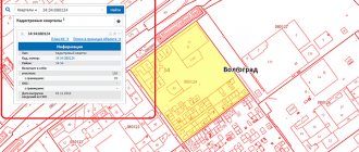
Plans of cadastral blocks showing the location of land plots and objects located within their boundaries are shown on the public cadastral map (PCC) in relation to each land plot:
- in the “information” section about the land plot – on the left side of the page with the map: the number of the cadastral quarter is indicated
- opens a schematic map of the control room showing the location of the charger
All cadastral blocks are separated by boundaries. Their boundaries may coincide with the boundaries of populated areas or be “more natural” - run along the boundaries of rivers, forests or highways, railways and other linear objects.
The cadastral quarter can be:
- rural settlement
- garden, country, construction partnership
- array of agricultural land or other types of land
- linear objects
- planning-independent part of the territory of a settlement: microdistrict
- city block
- an industrial or utility area bounded by red lines or other natural boundaries
A cadastral quarter is a land plot with boundaries:
- not intersecting with the boundaries of other neighborhoods
- representing a closed loop
The boundaries of the CC on the plan delimit a specific area with plots, vacant lands, with completed and unfinished structures, buildings, and linear objects.
The identification numbers of the cadastral blocks under which they are registered in the Unified State Register of Real Estate provide:
- maintaining their land records
- quick search for memory devices to determine their parameters
A plot of land in a cadastral quarter has a set area and boundaries. Its location is displayed in the general plan of the territory - a map of the area indicating the boundaries and neighboring objects.
Descriptions of all land plots and real estate objects on the territory of the cadastral quarter are contained in sections of the text part of the document - cadastral plan of the territory (CTP). In the graphic part of the CPT there are cartographic displays:
- objects located within the territory of the quarter
- boundaries of land plots, easements, territorial zones, security strips, etc.
The information contained in the CPT corresponds to the information registered in Rosreestr. Cadastral plan materials are provided in the form of extracts called a cadastral plan of the territory. The CPT contains information only about real estate objects registered in the cadastral register (clause 3 of Order of the Ministry of Economic Development of Russia No. 378 of June 20, 2016).
Plan of the minimum cadastral territory with the maximum amount of information about plots and objects
The cadastral plan of the territory (CTP) is an extract from the state real estate cadastre (GKN). It contains:
- descriptions of all land plots located within the boundaries of one cadastral quarter
- buildings
- outbuildings
- unfinished construction projects
- linear structures (power lines, water pipelines, gas pipelines, etc.)
- buildings and structures
- territorial zones established by the rules and development of the PZZ
Information in CBT is grouped into 2 sections:
- text part
- The grafical part
Text part of CBT
Contains detailed characteristics of real estate located inside the cadastral quarter:
- information about capital construction projects (CCS): type
- address or location description
- cadastral number
- type of object – building, structure, land plot, unfinished construction object
- characteristics of OKS
- characteristics of linear structures - length, depth
- indicators from project documentation
- address
Graphic part of CBT
KPT drawings and diagrams create a visual representation of the location of land plots and real estate in the cadastral quarter.
The main composition of materials for the graphic part of CPT:
- plans for landscaping, OKS, including unfinished structures and buildings - with the boundaries of all real estate objects, the coordinates of which were clarified during land surveying: the data may differ from the information on the PKK due to the greater accuracy of the KPT data
- type of signs (temporary or permanent)
- with graphic plans
- with areas, boundaries, list of coordinates
- with boundaries and coordinates
- number, type, class of compulsory medical insurance points, coordinate points (Y and X)
The recommended sample of CPT is in Appendix No. 8 to Order of the Ministry of Economic Development of Russia No. 378 dated June 20. 2021, taking into account changes made in 2021 - 2021.
Established forms of CBT
The cadastral plan of the territory is drawn up in one of 2 forms (Appendix No. 8 to Order of the Ministry of Economic Development of Russia No. 378 of June 20, 2016):
- in the form of an electronic document:
- electronic statements are certified by an electronic digital signature (EDS) - the authenticity of the signature can be checked on the Rosreestr website in an online format
- in the form of a paper document:
- the extract is certified by the blue official seal of Rosreestr or the seal of its territorial division - with the signature of the employee who prepared the extract
The legal force of both versions of extracts is equivalent.
Methods for ordering and receiving CBT
The cadastral plan of the territory is drawn up at the request of the copyright holders of land plots, real estate objects and any interested parties (Article 62 of Federal Law No. 218).
Of the documents required:
- passport only – for individuals
- a document confirming the authority of a person to act on behalf of legal entities
Using the Rosreestr resource, you can obtain a cadastral plan of the territory from the Unified State Register of Real Estate in an online format. The same opportunity is provided on the State Services website.
The usual methods of submitting a request and receiving CPT materials on paper are not excluded:
- personally
- by mail
- through MFC
KPT information is current as of the date it was provided.
Practical value of CBT
CBT materials are needed for different purposes. They are needed by cadastral engineers, construction companies, current and future owners of land and buildings, their tenants and users. Depending on the purpose for which a cadastral plan of territories is required, the applicant is provided with the necessary sections of the plan.
Areas of application of CBT
- complex cadastral works
- calculation of cadastral value of real estate objects
- preparation: land plot plan
- technical plan
- technical documentation for the memory
- including for communications
The CPT provides information on the boundaries and characteristics of lands. Using the plan is a guarantee of eliminating errors associated with the overlap of plot boundaries.
KPT information is necessary to draw up a diagram of the location of the land plot in the cadastral plan of the territory (SRZU on KPT). Without such a scheme, it is impossible to create a plot of land that is in state/municipal ownership, in order to obtain it without bidding for lease or ownership.
Reliable materials about registered linear objects, security zones, restrictions established in accordance with their types are necessary for owners of landfills through which networks pass. It is possible that the encumbrance will affect the very possibility of constructing the building or the installation of underground communications.
In the process of forming a land plot within the cadastral quarter, the plot acquires parameters and characteristics. Its cadastral value is established. It affects the amount of land tax and the amount of rental payments.
The KPT database of legally relevant information about real estate and land plots, the availability of materials to an unlimited number of people, the ease of obtaining data are evidence of the practical usefulness of the document.
Documentation content: graphic and text part
CBT is a huge content of various information and information. Everything is divided into text and graphic sections. The text part describes all objects in great detail, and the graphics provide a visual representation in the form of diagrams and drawings. All this makes the work of the cadastral engineer easier. With the help of this information, he will be able to carry out land surveying and prepare technical documentation for a separate storage unit.
A lot of information can be found on the public map. But the data presented will not be enough. The CPT will give us key information about the boundary and nature of the land that is adjacent to the land being studied. Documentation will allow you to avoid errors and there will be no overlap of boundaries.