What it is?
A boundary plan is a document containing certain data about the site. It is drawn up upon the formation, division, merger or distribution of plots. It must contain information about the address, boundaries and area of the site, its category and permitted use. Information about the owner is also included. This information in some situations can be obtained from Rosreestr, and in others it is prepared for entry into it.
Depending on the purpose of creation, the design also differs . For example, when merging plots that are already registered in the cadastral register, information about their boundaries must be obtained from Rosreestr. If their combination is possible, a boundary plan is prepared based on this information.
If multiple parcels are joined to further subdivide along new boundaries, the plan contains information about both the connection and the subdivision. This allows you to carry out surveying once and draw up one document.
Important! The boundary plan necessarily shows not only the boundaries, but also the history of their formation and changes. This is how it differs from the boundary plan.
When clarifying the boundaries of a site or allocating a new one, if it borders on existing ones, it is necessary to coordinate the boundaries with other owners. It is formalized by an act, which is also included in the plan.
Are you planning to draw up a boundary plan for your land plot? Are you wondering if it has a validity period, and also how much the procedure will cost?
The answers are here!
Examples
Examples of generating electronic versions of documents using XML Constructor and their printed counterparts based on electronic versions using XML Reports.
The proposed archives contain a set of files that are necessary to form a package of information for carrying out various cadastral actions. Each of the examples contains an XML file in the native format (*.xcn) of the XML Designer , a created XML file in the target format (GKUZU_*.xml, GOUKS_*.xml, etc.) generated according to the corresponding approved XML schema , converted from the target XML file into a printed representation by the XML Reports , a printed image of the document in PDF format, files of diagrams and drawings (usually *.jpg), application files (either *.jpg or *.pdf).
To demonstrate the operation of the XML Designer program and the principles of creating information packages and converting them into the target format, you need to open the file in the native XML Designer format with XCN permission. To generate the final target package required for submission to the cadastral registration authority after opening the file in its native format, you need to call the Save-Convert command and specify the necessary settings in the Generate Target Package dialog. To demonstrate how the program creates XML Reports in a printed representation of a document based on its electronic counterpart, you need to convert XML files into the final (target) format by selecting the required template from the list.
Boundary plans. Circuit version - 6
An example of the formation of a boundary plan for the formation of a land plot from lands in state or municipal ownership.
An example of the formation of a boundary plan for the formation of a land plot by combining land plots.
An example of the formation of a boundary plan for the division of an existing land plot.
An example of the formation of a boundary plan for the division of an existing land plot for a single land use while maintaining the original land plot within the changed boundaries.
An example of the formation of a boundary plan for the formation of a part of a land plot.
An example of the formation of a boundary plan for the formation of a land plot through the redistribution of a land plot and municipally owned lands.
An example of the formation of a boundary plan for the formation of a land plot by redistributing adjacent land plots.
Boundary plans. Circuit version - 5
An example of the formation of a boundary plan for the formation of a land plot from lands in state or municipal ownership.
An example of the formation of a boundary plan for the formation of a land plot from lands in state or municipal ownership and clarification of the border of an adjacent land plot.
An example of the formation of a boundary plan for the formation of a land plot by combining land plots and forming part of a land plot.
An example of the formation of a boundary plan for the formation of a part of a land plot.
An example of the formation of a boundary plan for the formation of a land plot through the redistribution of a land plot and municipally owned lands.
An example of the formation of a boundary plan for the division of an existing land plot and the formation of a part of the land plot.
An example of the formation of a boundary plan to clarify the location of the border and (or) area of the land plot.
An example of the formation of a boundary plan to simultaneously clarify the location of the border and area of 3 land plots while simultaneously clarifying part of the boundaries of adjacent land plots.
Boundary plans. Circuit version - 4
An example of the formation of a boundary plan for the formation of a land plot from lands in state or municipal ownership.
An example of the formation of a boundary plan for dividing an existing land plot into two new ones.
An example of the formation of a boundary plan for the division of an existing land plot that has three parts with the formation of 151 new land plots and 40 parts. When land plots are formed through division, new permitted uses and addresses are simultaneously assigned to the plots on the basis of the Resolution of the local government body.
An example of the formation of a boundary plan to clarify the boundaries of a declarative land plot. The area of the land plot upon clarification is increased by an amount not exceeding the maximum minimum size of the land plot.
An example of the formation of a boundary plan for the simultaneous clarification of the boundaries of two adjacent land plots as part of correcting a cadastral error.
Boundary plans. Circuit version - 3
An example of the formation of a boundary plan for dividing an existing land plot into two, while one of the created plots is multi-circuit consisting of three contours.
An example of the formation of a boundary plan for dividing an existing land plot into 74 new land plots.
An example of the formation of a boundary plan for the formation of a part of an existing land plot.
Technical plans. Circuit version - 3
An example of the formation of a technical plan based on a declaration of real estate for registering a building.
An example of the formation of a technical plan based on the BTI technical passport for state accounting of changes.
An example of the formation of a technical plan based on a declaration on the property and a court decision to take into account changes in the apartment after the redevelopment.
An example of the formation of a technical plan based on a declaration on the property and a court decision to take into account changes in the apartment after the redevelopment.
An example of the formation of a technical plan based on a declaration on a real estate property for registering an apartment building and apartments.
An example of the formation of a technical plan based on the technical passport of a real estate property for registering an apartment building and apartments.
An example of the formation of a technical plan based on the Technical Data Sheet for registering a structure.
Technical plans. Circuit version - 2
An example of the formation of a technical plan based on the BTI technical passport for registering a building.
An example of the formation of a technical plan based on a declaration of real estate for registering a building.
An example of the formation of a technical plan based on the technical passport of the BTI and a court decision for registering a building after reconstruction.
An example of the formation of a technical plan based on a declaration on a real estate property, an equity participation agreement and an acceptance certificate for registering an apartment.
An example of the formation of a technical plan based on the technical passport of the BTI and a court decision to take into account changes in the apartment after the redevelopment.
An example of the formation of a technical plan based on the technical passport of the BTI and a court decision for registering an apartment after reconstruction.
An example of the formation of a technical plan based on design documentation for registering non-residential premises.
An example of the formation of a technical plan based on a declaration of real estate for the division of an existing premises into two. A separate technical plan has been created for each of the premises being created. One of the rooms is multi-level, consisting of three levels.
An example of the formation of a technical plan based on design documentation for registering the construction of a cable line.
An example of the formation of a technical plan based on design documentation for registering the construction of a water pipeline.
An example of the formation of a technical plan based on a declaration on a real estate property and an extract from the municipal property register for registering the construction of an artesian well.
An example of the formation of a technical plan based on a declaration on a real estate property for registering the construction of a transformer substation.
Special symbols
Symbols for boundary and technical plans. Designed in the form of tables, saved in PDF format and intended for inclusion in applications of boundary and technical plans.
Zone information - 5
An example of generating a data package for transmitting information about territorial zones and zones with special conditions for the use of territories to the state real estate cadastre.
Map (plan). Circuit version - 1
An example of the formation of a map (plan) for entering information about the border of a village into the cadastre.
Map (plan) of the zone. Circuit version - 2
An example of creating a map (plan) for entering information about the power transmission line protection zone into the cadastre.
An example of creating a map (plan) for entering information about the security zone of a cable line into the cadastre.
Map (plan) of the border. Circuit version - 2
An example of the formation of a map (plan) for entering information about the border of a village into the cadastre.
Request for information from the State Tax Committee. Scheme version - 3 (RequestGKN03)
An example of forming a request for information included in the state real estate cadastre: request for an extract and request for KPT.
Statements. Scheme version - 1 (StatementGKN01)
Examples of generating XML application files such as: an application for cadastral registration of a land plot, an application for state registration of a building, premises, an object of unfinished construction, an application for the provision of cadastral data in the form of a cadastral extract, in the form of a cadastral plan of the territory, an application for provision of additional documents for cadastral registration for the case of registration of a plot and the case of registration of a real estate property. It should be taken into account that in order to form the final package for cases of registration or provision of additional documents, a package containing a boundary or technical plan must be linked to the application file. The application files with attachments, certified by digital signature, must then be packed in a ZIP archive and named according to the template: req_GUID.zip.
Statements. Scheme version - 17 (CR_ZC_REQ_Reqest)
Examples of generating XML application files such as: an application for cadastral registration of a land plot, an application for state registration of a building, premises, an object of unfinished construction, an application for the provision of cadastral data in the form of a cadastral extract, in the form of a cadastral plan of the territory, an application for provision of additional documents for cadastral registration for the case of registration of a plot and the case of registration of a real estate property. It should be taken into account that in order to form the final package for cases of registration or provision of additional documents, a package containing a boundary or technical plan must be linked to the application file. The application files with attachments, certified by digital signature, must then be packed in a ZIP archive and named according to the template: req_GUID.zip.
Notice of pledge of movable property submitted to a notary. Scheme version - 2.0
Examples of notifications about the occurrence of PP1, about a change in PP1, about the exclusion of PP1 of the pledge of movable property, notifications about the occurrence of PP2, about a change in PP2, about the exclusion of PP2 of the pledge on bonds - only 6 examples.
Notification of bank accounts according to FATCA law. Scheme version - 1.1
Examples of US taxpayer bank account notices under FATCA.
Inspection report. Circuit version - 1
An example of a data package for an electronic version of a survey report confirming the termination of the existence of a property in XML format.
Information about the results of verification of measuring instruments.
An example of generating an XML file with information about the results of verification of measuring instruments for further loading into the Federal State Information System of the Federal Agency for Technical Regulation and Metrology.
What does he look like?
The boundary plan can be presented both electronically and in printed form. The printed version is compiled on A4 paper. All pages are numbered and filed.
There should be no major corrections; minor ones are certified by the signature of a cadastral engineer. Each sheet is certified by his signature and seal. The electronic version is certified with a digital signature.
In both versions, the document consists of several sections. Information is included both about the site being formed and about previously existing ones. The data is presented in the form of tables, diagrams, drawings. At the end, an act of approval of boundaries and other necessary documents are attached.
Drawing up a boundary plan of a land plot with your own hands
In an effort to save money, citizens sometimes draw up a plot plan with their own hands. Such a procedure is not prohibited , but the document drawn up will not acquire legal force .
Not every specialist with the status of cadastral engineer is allowed to survey. Only legal entities that have undergone specialization and received a license to provide the designated services are allowed to carry out cadastral work.
The cadastral engineer must have an electronic seal with double protection.
Preparation of a boundary plan for a land plot is based on the following mandatory conditions:
- Reliance on information received in the form of an extract from the State Real Estate Cadastre (GKN).
- Accuracy of measurements using high-precision geodetic surveying. The permissible errors are no more than 5 cm. If the norm is exceeded, a cadastral error occurs that must be corrected.
- Indication on the drawing and in its paper accompanying the exact coordinates of the turning points of the site.
- Execution of the cadastral document using the standards of conventional topographic signs, on electronic and paper media.
- Application of approval acts.
The act of approving the boundaries of a land plot is a sample example.
Since creating the designated document at home is almost impossible, you should contact a specialist .
However, we should not discount the moments when citizens seek to establish regulations for the use of land before (or instead of) the land surveying procedure. For example, residents of the village are allocated plots for use for vegetable gardens. The lands belong to the administration, and villagers simply use them to plant vegetables or potatoes.
Such traditions have developed in many settlements since the functioning of collective farms; their feasibility remains the current state of affairs to this day. If interested, they can establish regulations for the use of land by drawing up a land surveying plan based on the principle of agreement, based on an act.
In this case, land is allocated from an established symbol, for example, from a permanent structure or the bank of a river (lake). A conditional number of meters is measured and a boundary is established. In this way, all plots transferred to citizens are measured out one by one and numbered in accordance with the order of land use. A drawing of the plots is drawn up indicating their area and numbering.
It will not be difficult for draftsmen to identify the main elements of the plan. He will be able to take the boundary plan on the Rosreestr website as a sample and carry out the work according to the sample. Such a plan should be agreed upon with a representative of the village administration and documented in an act. All participants are required to sign here.
These papers are not prohibited from being used for internal convenience, but they do not have any legal regulations. When privatizing such lands, you should carry out an official procedure for allocating land by land surveying, following the instructions. It is better not to present a plan drawn up in your own hand to third parties.
It is better for owners and other legal holders of land plots not to draw up homemade documents, since there is no practicality in such.
What parts does it consist of?
This document consists of two parts: informational (or text) and graphic.
Information
The information part begins with a title page and descriptions of sections. Which sections are included in it depend on the purposes of land surveying. These are any documents about a land plot.
At the end of the text part there is an act of approval of boundaries (if required) and a conclusion from a cadastral engineer.
The graphic part contains information from the cadastral plan or extract from the allotment. These are site diagrams, border coordinates and access to the site. A single standard for marking boundaries, characteristic points, etc. is used.
In addition to the title page and contents, the required sections of the information part include:
- accurate initial information;
- data on all measurements and calculations and how they were carried out;
- information about the resulting land plots;
- and about those adjacent to them;
- about all approaches and paths to them;
- conclusion of the cadastral bureau engineer.
The initial data depends on the purposes of cadastral work. When merging, dividing or redistributing plots with adjacent boundaries, information about the original shapes of the plots is included. This is their location (address), area, location of borders and coordinates of turning points.
When clarifying boundaries according to Law No. 221-FZ of July 24, 2007, it is imperative to coordinate the boundaries with all interested parties, that is, with neighbors.
This can be done at a general meeting or with each of them separately. Then an act on the approval of boundaries is drawn up, which is then signed by everyone with whom the approval was carried out, as well as by the cadastral engineer. It is also included in the text section.
The information part ends with the conclusion of the cadastral bureau engineer.
This is an explanation and justification of the calculations and measurements made, as well as the results obtained based on them.
The requirement to clarify these issues arose on November 24, 2008 by order of the Ministry of Economic Development No. 412.
A conclusion is required if:
- Differences were identified in the actual location of the boundaries and those indicated in the cadastral plan.
- In cases where the location of boundaries was clarified.
- It is possible in other cases as decided by the cadastral engineer.
Help: In practice, it is always recommended to compose this part. If it is not there, the Cadastral Chamber may refuse registration due to lack of justification for the configuration, location of boundaries, etc.
You can try to challenge such a refusal in court, but it will take longer and be more expensive.
The land surveying procedure is not cheap! But it is possible to delimit plots free of charge at the expense of the municipality!
Find out if you have a reason to do so.
Graphic
The graphic part contains:
- diagram of the land plot(s) being formed;
- diagrams of sites that previously existed;
- drawings of sites and access roads;
- outlines of plot boundaries.
All diagrams and drawings are made using standard designations of boundaries, points and other objects. Signatures for them are also made in the same style.
Rules for drawing up an agreement
After consideration and acceptance of the application by the organization carrying out work to establish the boundaries of land territories, a standard agreement for this type of service should be drawn up. The contract is the main document, which is then attached to the land survey document. Therefore, it must be drawn up carefully, taking into account all the legal subtleties.
Cadastral work is regulated by Federal Law No. 221. The law states that only licensed cadastral engineers can carry out land surveying services.
- At the beginning of the contract, you must indicate the place of drawing up the act and the date. The preamble contains the full name of the organization that will carry out the division of the plot, as well as the full name of the customer.
- Further, the text of the document includes the essential parties of the transaction: subject and cost.
The subject is a land plot, the main indicators of which are included in the text. The customer determines and the contractor prepares the boundary plan. - Characteristics of the land plot:
The land is located in the Moscow region, Pushkinsky district, village. Pravdinsky.Cadastral No. 50:13:0050202:000.
The area of the site is 5 hectares.
The cost of the work performed is included in the next clause of the contract.
The cost of the work is 22,000 rubles.
Payment is made after the service is provided.
- The deadline for the work is also included in the text:
The start date is the date of signing the document. The end date is 90 days from the start of the contract.
The land surveying procedure can cost you completely free! Find out how to demarcate a plot at the expense of the municipality!
A necessary point is the obligations of the parties to each other. The contractor must carry out preliminary work before the survey and study all documents related to the site. Measure and mark boundaries, establish boundary marks.
The end result of the contractor’s work is the registration of a land survey document , which is sent to Rosreestr for registration.
The customer is obliged to provide all documents required for the work, provide unhindered access to the land, notify all owners of adjacent territories, and also make full payment based on the results of the work.
The agreement is concluded in 2 copies. At the bottom of the document are the details of the parties and contact information, signatures and date of preparation.
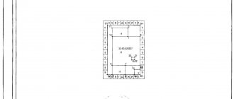
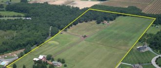
Photo of the document
You can see what some pages of the graphic part of the boundary plan look like in the photo below:
Reasons for receiving
According to the regulations, each plot must be registered with the cadastral register. This procedure could have been performed earlier, without land surveying. Accordingly, undemarcated plots could be transferred from one owner to another.
The legislation does not limit owners' property rights , in accordance with Article 35 of the Constitution of the Russian Federation and Chapter 17 of the Civil Code. This rule created a precedent for the presence of undemarcated plots put up for auction in large quantities.
The purchase of such plots leads to legal consequences in the form of disputes between the owners. In such cases, coordination of the boundary plan of the land plot is very useful. Also, land surveying (see what it is) is required when allocating (cutting) land or reorganizing a site by connecting or dividing.
The listed cases require contacting the geodetic (cadastral) service.
The basis for carrying out land surveying is an application written and submitted by the owner or co-owners - if the land plot is jointly owned. And the basis for obtaining a boundary plan is to carry out topographical and geodetic work.
Application for land surveying.
Legend
The following notations are accepted:
- The boundaries are determined by lines, with those that existed before cadastral work drawn in black, and those that appeared during the land surveying process in red.
- A solid line is used for boundaries whose location is determined with sufficient accuracy, and a dotted line - with insufficient accuracy.
The thickness of the lines is also regulated - 0.2 mm. The length of the dotted line is 2 mm, the distance between them is 1 mm.Help: The required accuracy of measurements depends on the purpose of the land. For example, for gardening and individual housing construction it is 0.2 meters.
There are 4 options for marking boundaries:
- Already existing, defined with sufficient accuracy - a solid black line.
- Existing, but defined with insufficient accuracy - a dotted black line.
- Newly formed or refined, if the accuracy is sufficient - with a solid red line.
- New, but lacking in accuracy - dotted in red.
The characteristic (turning) point of the border is indicated in black:
- a solid circle with a diameter of 1.5 mm, if its location is established accurately;
- circle of the same diameter if the location is not determined precisely enough.
Land plots and their individual parts are also designated in a strictly defined way. The sections are written like this:
- Those that originally existed, from which others are formed by division, merger or redistribution - with a colon and a number from the cadastral plan. Additionally, they are highlighted by underlining and at the same time italics.
- Plots whose boundaries are being clarified or changed are marked with a colon and the number indicated in the cadastral plan.
- Formed from state or municipal lands, as well as by consolidation or redistribution - a colon, the letters “ZU” and a number.
- Formed using a section or separation from an existing one - a colon, the number of the original section, a colon, the letters “ZU” and a number.
- Multi-circuit section - with the section number and the serial number of the contour in parentheses.
And their parts are like this:
- Already existing ones - colon, number, slash and part number.
- Vanishing - the same, but using italics and underlining.
- When designating the parts being formed, “chzu” and the serial number of the part are added to the number of the land plot after the slash.
- Parts included in the composition during redistribution - the number of the original site with a colon, the letter “p” and the number of the part. If there are several such numbers, the number of the cadastral quarter is added in front (without separators).
- Included in newly formed plots (from municipal or state lands) - with a colon, the letter “p” and a number.
- When designating a part of a multi-circuit section, “chzu” and the part number are added to its number after the slash, and then, in parentheses, the contour number.
Turning points are indicated:
- existing before, unchanged or with a specified location in number;
- those that have ceased to exist - with a number written in italics and underlined;
- newly formed ones - with the letter “n” and a number.
Thanks to the use of uniform symbols, not only the surveyor can understand what exactly is shown on the diagram. Anyone who knows these signs is capable of this.
Technical plan
The technical plan is also drawn up in programs for land management and land cadastre; it is prepared for:
- residential or non-residential building;
- apartment building;
- structures;
- premises for residential and non-residential purposes;
- unfinished construction project;
- parking spaces;
- single real estate complex.
The document is drawn up in the following cases:
- when it is necessary to register a property or part of it with Rosreestr;
- Additional information has appeared that needs to be entered into the real estate register.
The content of the document is regulated by Order of the Ministry of Economic Development No. 953 dated December 18, 2015. It includes both graphic and text parts. In the program for generating technical plans, you can create:
- real estate drawing;
- layout of the object within the site;
- schematic designation of geodetic constructions;
- floor plans;
- description of building characteristics;
- related documentation;
- a declaration drawn up by the owner of the real estate.
All listed documents in paper or electronic form are signed by a cadastral engineer.
Inspection report
Necessary for deregistration of a property. It is convenient to compile it using cadastre software. Automation helps to prepare the type of documentation in accordance with Order of the Ministry of Economic Development No. 861 of November 20, 2015.
Such a document must be made after a personal inspection of the site by an engineer and recording of the termination of operation of the property due to demolition or complete destruction.
It is most convenient to carry out all activities and preparation of documents in conditions of optimal computer equipment. This facilitates both the work of engineers and the speed of service delivery.
Features of forest land surveying
Law No. 221 “On Cadastral Activities” notes the possibility of drawing up a boundary plan for part of a forest area with the following deviation from the general rules:
- approval of boundaries takes place without a land surveyor visiting,
- boundary points are not placed on the ground,
- It is possible to publish a notice with the date of setting the boundaries in print without mailing.
When carrying out land surveying of a forest plot for cadastral registration, you must keep in mind that there should be no bodies of water - rivers or lakes - on its territory. The Land Code prohibits land surveying of forest areas with surface water.