Bringing out the boundaries of a land plot in nature is a type of geodetic work that is in great demand on the market these days. Yes, according to the law, for private needs, this procedure is not mandatory, unlike land surveying, but this does not detract from the need for it (more information about the procedure for drawing boundaries is written here). But what is the act of removing the boundaries of a land plot, is it necessary and what should be in it, we will consider in this article.
Delineating the boundaries of a land plot: what is it?
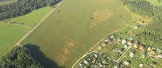
Carrying out the boundaries of a land plot in nature is a way of restoring (establishing) boundary lines running between adjacent plots. Refers to cadastral activities. It consists in determining the area of the land plot by highlighting the parameters and configuration of the plot.
To draw boundaries into reality, only relevant information is used, which specialists receive through:
- Ordering an extract from the state real estate cadastre (GKN) or using a cadastral plan of the general territory, with neighboring plots already allocated.
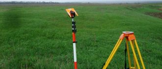
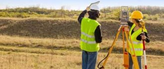
- Carrying out geodetic work on the site, according to the received plan.
The information is based on the coordinates of turning points of adjacent sections. The authority to preserve this information is vested in the Rosreestr service, and access to it is granted to cadastral service specialists and a certified cadastral engineer.
As a result of carrying out the designated procedure, the following goals are achieved that are required for the use of the allotment or property disposal as such:
- the storage area within the boundaries is determined;
- the identified parameters are agreed upon with the owner and neighbors;
- are fixed in the information of the State Property Committee.
The land surveying rules and instructions accompanying the removal of the boundaries of a land plot on the ground are based on the Federal Law on the State Property Committee, adopted on July 24, 2007, under No. 221-FZ.
Why is it necessary to restore points?
You can find out the specific boundaries of an object using a procedure called site breakdown. This type of work is necessary in this case, when the buyer wants to know the exact area of the plot. In order to avoid conflict situations with neighbors, you need to carry out the location of the points in time.
During the design of any object, it is necessary to carry out a breakdown of the site. Setting boundary points allows you to determine the size, shape and boundaries of the site. At the time of work, the building is also connected to communication lines and the transport network.
Landmarks of the boundaries of the land plot
Boundary signs of the boundaries of a land plot - this is the line between plots belonging to different owners, are formalized by installing these signs.
They are installed at the turning points and fixed:
- in kind - with special pegs;
- in the cartographic version of the storage facility location plan;
- on paper and electronic versions of State Property Committee information.
The signs are transferred to the owner by a special act after the pegs are installed. Each peg must be provided with a special label or plate with coordinate data. It is also permissible to record the coordinates with a non-erasable inscription on one of the sides of the body of the boundary sign.
After the transfer of the act of establishing and agreeing on boundaries, the information becomes available to the information bank of the State Property Committee. Accordingly, it is unacceptable to move them and change the established position. Since they are built on the boundary between plots, there is no need for these illegal actions.
When signs are not placed
There are a number of situations when it is impossible to put boundary signs or it does not make sense. This is about:
- prohibition of carrying out the specified work in a specific territory, then the boundaries can be marked with paint,
- the boundaries of the site coincide with natural objects or a fence (at the owner’s request, boundary signs may not be placed),
- impossibility of placing signs for objective reasons, for example, on a body of water,
- boundaries of adjacent areas that have one turning point where boundary signs are placed. Usually they are already included in the documentation and descriptive part of the land management papers of each of the plots.
Owners are required to carefully monitor boundary signs so that they do not have to re-install them on the property.
Removal bases
The basis is considered to be the documented legal capacity of the owner or other title holder of the land plot who needed to restore the boundaries of the land. These may include:
- realtors putting up land for auction;
- owners - sellers of the site;
- neighbors between whom a dispute has arisen;
- persons reorganizing the memory;
- bona fide owners planning the distribution of development zones.
Legal capacity is confirmed by submitting proof of title to the cadastral engineer.
Situations often arise when undemarcated lands are surrounded by a fence or a permanent structure begins to be erected. As a result, an overlap of boundaries is revealed, which regulates the termination of unauthorized activities and the liquidation of work results on the basis of Article 7.1 of the Code of Administrative Offenses of the Russian Federation.
How to convert to degrees
The coordinates of points can be reflected in the form of specific coordinates, which can be represented:
- in minutes and seconds (this method is already considered obsolete and is not currently used);
- in degrees and minutes (indicating decimal fraction);
- in degrees with a decimal fraction - this method of indicating data is more modern and in practice it is most often used.
In some cases, there is a need to take steps to convert coordinates to degrees. To do this you will need to do the following:
- in the event that coordinates are given that reflect degrees with a decimal fraction, they are naturally converted to a value in degrees and minutes. To do this, the indicated values before the comma or period are rewritten, keeping all the numbers, and these will be indicators of degrees, which already indicate specific coordinates on the ground. Next, it becomes necessary to convert the value of the fraction into coordinates - into degrees.
To do this, it is multiplied by 60 and thus the value is converted into degrees. The resulting number will be the minutes. Similarly, with such an action, the translation into the applied system should be carried out both with the latitude of the coordinates and with its longitude. For example, the result obtained should have the following indicator: 12°45.32'N, 31°51.06'E.
- if conversion is necessary with degrees containing minutes and seconds, the integer remains the same. Then the value of the number of minutes for this number after the decimal point is taken and multiplied by 60, thus obtaining the fractional part of the indicator. As an example, this view should be given - 22°15'20.9916″N, 17°35'3.6338″E.
This fact is due to the fact that in real conditions, individual amendments may be made to the terrain and location of a particular site, with which the owner of the site may not even be familiar. At the moment, there are a certain number of programs on the network that allow you to calculate the values of coordinate degrees relative to the PT boundaries of the site automatically.
So, the allocation of a land plot and the establishment of its boundaries cannot be carried out without first identifying turning points and reflecting their coordinates in cadastral documents. Depending on the type and purpose of the cadastral plot, there is a certain accuracy of indicators that must be observed.
Step-by-step instructions for restoring memory boundaries
Where to contact
To restore the boundaries of a land plot, you should contact a geodetic company engaged in business activities. To do this, you should check the availability of a license for the designated type of work and write an application.
It is also permissible to order land surveying at the MFC, where information about cadastral engineers authorized to carry out this work is stored.
Price
If you plan to remove the boundaries of a land plot in situ, the cost of cadastral work may vary, depending on a number of parameters:
- storage location;
- land categories;
- total area and configuration of the site.
Typically, companies set a price depending on the number of boundary signs installed. One boundary sign costs from 500 rubles to 1,500. Sometimes higher prices are found, depending on the status of the company and the use of its logo on the sign or label of each installed peg.
On level areas, install from 4 pegs. If the configuration is complex, the entire bend is formed by installing signs at the turning points.
Deadlines
If the company does not have a queue, then the cadastral engineer should only receive an extract from the State Property Committee, which is prepared within a week. Based on it, develop a boundary plan (depending on the purpose, there are different types of boundary plans) and carry out geodetic work. Field work is usually carried out in one day, documentation preparation takes approximately a week. From this calculation, it is allowed to focus on 2 weeks.
Land survey plan
Required Documentation
The application, written in hand by the owner of the land plot, is accompanied by land surveying documentation confirming that the designated plot belongs to him on the basis of one or another form of right. Third parties are not allowed to submit an application. Accordingly, it is required:
- passport;
- certificate of ownership (other form of right);
- cadastral passport of the land plot;
- for representatives – a notarized power of attorney;
- after payment for services - a receipt.
If land surveying is required to register a land plot for cadastral registration, a certificate of ownership may be missing. In this case, it is permissible to present a title document for the land. For example, an act of allotment of a plot issued by the administration. Such documents have no statute of limitations.
Algorithm for the process of removing boundaries
After the corresponding application has been submitted, the owners of the plot can only agree on the time of topographic work, which will be carried out by topographers, under the guidance of a cadastral engineer.
Before this time, the cadastral engineer must receive an extract from the State Property Committee, according to which he will prepare a cadastral survey project. If he restored the boundaries of neighboring plots, he may have at his disposal a cadastral plan of the territory. If the boundaries of neighboring land plots are recorded on it, then drawing up a designated boundary document will be much easier.
On the appointed day, the owner of the land plot and surveyors meet at the site. In accordance with the drawn up plan, the cadastral engineer determines the locations of the turning points where the pegs are driven in.
As a rule, by this moment the acts of drawing out boundaries and the act of agreeing on boundary boundaries with neighbors are ready. They are signed by the participants. The cadastral engineer transfers paper versions of the land survey to the title holder. And the electronic version is sent to the State Committee for Taxation.
What documents need to be prepared?
Documents required to perform work on determining boundary symbols:
- Statement of the established form, on the basis of which the work is carried out;
- Extract from the Unified State Register of Real Estate;
- Passport;
- Documents confirming land ownership;
- Urban development plan of the site (if available).
To obtain or renew these certificates, it is better to contact professionals ☎
The act of drawing out the boundaries of a land plot: what is it?
This is a document signed by the cadastral engineer, the owner of the land plot and the participant (participants) in the survey of the site for the establishment of boundary signs.
The act of removing the boundaries of a land plot has legal force as a guarantee of the right to use and dispose of the plot for its intended purpose. Mandatory in case of disputes with neighbors that are considered in court.
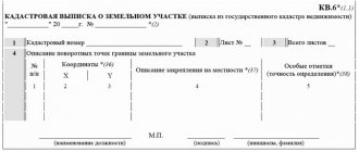
The act of drawing out the boundaries of a land plot is a sample.
In the next video, we recommend you look at why the act of removing the boundaries of the site is needed.
Structure and content of the document
The specialist develops an act of delineating the boundaries of the site and a technical report (mandatory attachment). The certificate contains the following data:
- Information from the State Real Estate Cadastre about the site;
- Information about the owner of the site and neighbors;
- Data on measurement methods;
- Type and number of points taken into nature during the work;
- Attachments to the document;
- Customer signatures;
- Seal and signature of a cadastral engineer or surveyor engineer;
The technical report includes text and graphic parts, with attached appendices. The main sections are:
- Location of the site;
- Geodetic information;
- Coordinate system for measurements;
- The basis for the breakdown of the site;
- Description and scope of research;
- Information about the contractor;
- Methods and equipment for work;
Having completed the technical documentation, the professional certifies it with a signature and seal (seal of the organization). As a result, the act of removal comes into legal force.
professionals are members of SROs who have qualification certificates. The company's engineers constantly improve their knowledge and abilities. This confirms the high level of performance of the work.
Filing a claim to restore the boundaries of the land plot
If the boundaries of adjacent plots overlap each other or if a cadastral error occurs, registration work will be suspended until the circumstances are clarified. Depending on the extent of violations found, registration may be suspended, with the right to file a lawsuit.
The same applies to disputes with neighbors. For example, the buyer purchased a plot without land surveying, the boundaries of the land plot were established according to the words of the seller. During the construction of a permanent structure, a neighbor pointed out a violation of boundaries. A dispute arose. Otherwise, the owner could find out that his neighbor had unlawfully enlarged his plot, violating his rights. Such and similar cases require going to court.
The claim is filed in arbitration of general jurisdiction in the area where the real estate is located.
The deadline for filing a claim should be based on the framework established for the limitation period (Article 196 of the Civil Code of the Russian Federation). In general, the review procedure takes no more than 2 months.
Statement of claim
The claim is filed in the name of the magistrate, indicating the parties to the dispute. In the main part you should indicate:
- Circumstances under which ownership of the land plot arose.
- Its cadastral characteristics, location.
- The circumstances under which the dispute arose. Evidence of the legality of the claim, an indication of the violation of the rights of the plaintiff by the defendant.
- Measures taken by the plaintiff to resolve the dispute by agreement of the parties (pre-trial procedure).
- The defendant's response to an attempt to resolve the dispute.
- Appeal to the court for recognition of the claim.
The following documents are attached to the application:
- on the conduct of pre-trial procedures;
- on the rights of ownership of land plots;
- evidence of violation of the plaintiff’s rights;
- the act of drawing boundaries into reality;
- for representatives – a notarized power of attorney.
State duty
The state fee is paid in the amount of 300 rubles and is attached to the documentation package.
After consideration of the issue in court, the disputing parties will be issued an extract on the decision made. It is prepared within 3 days and comes into force 10 days from the date of issue.
Bringing out boundaries in nature determines the regulations on property claims of persons. Carried out as a result of geodetic and cadastral work on the site.
Did you like the article? Want to know more about land surveying? Go to our section dedicated to this land topic.
Approval based on actual use
Some neighbors may, without involving cadastral specialists, agree to establish the coordinates of the site.
To determine the size of the territory based on actual use, all interested owners should be notified of the procedure and the conditional boundaries of the plots should be identified.
Next, the process of establishing the boundaries of real estate objects looks like this:
- secure the boundaries of the plots using boundary signs, fences or pegs;
- if everyone is satisfied with certain boundaries, the owners should contact a specialized organization and order a boundary plan from an engineer;
- On site, the specialist will fix the coordinates of the plots and enter the information into the documents;
- After the act of determining the coordinates has been endorsed, a land surveying plan is drawn up, indicating the exact limits and dimensions of the site.
Owners of real estate will only have to submit the appropriate package of papers to Rosreestr for state registration according to the sample.
Specifics of applying boundary marks
At first glance, it may seem that this is an elementary job that any landowner can handle. Indeed, what is so difficult about taking the necessary coordinates from the database and marking border turning points on the surface of the earth? However, such a specific process is fraught with many nuances and pitfalls that can significantly complicate the implementation of measures in practice. Among them:
- The need to use modern geodetic equipment to mark boundaries as accurately as possible;
- In-depth knowledge and competence in the field of land management;
- Documentation skills;
- Possibility of access to the database of land management companies, to which, admittedly, there is only limited access.
The best way to restore land boundary markers as accurately as possible with minimal investment of time, money and effort is to contact a company that specializes in providing this type of service.