The land surveying procedure determines the boundaries of the land plot, which are fixed in the relevant documents. Thus, the owner receives an individually defined plot and the right to dispose of it. And fixing the identified boundaries is called setting out the boundaries of the land plot. And it involves installing boundary markers (for example, a fence) on the ground.
Cameraman Alisa Lawyer
Dear readers! Our articles discuss typical situations for resolving legal issues, but each problem is unique. Therefore, if you need a FREE consultation with a lawyer, call ext 946 (Moscow and Moscow region) ext 651 (St. Petersburg and Leningrad region)
What is site surveying?
Engineering and geodetic surveys that help determine the boundary marks of a site are called site surveying. The essence of this work is to determine the turning points of the plot boundaries and move them from the map to the land plot.
This procedure is also called: breaking up a given area, setting out in nature, restoring boundaries, defining boundary symbols, since the exact definition is not regulated by law. Upon completion of this work, an act of drawing out the boundaries of the site is drawn up.
This work can be performed by a professional who has a specialized education, experience in carrying out this work, a license and qualification certificate, a member of an SRO, or who has a SRO license that allows carrying out engineering and geodetic surveys, as well as removing boundaries (work is prohibited without a license).
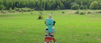
To carry out point placement, professionals use high-precision GPS measuring instruments. The use of these devices helps to avoid errors in measurements and shows the properties of the object in a three-dimensional coordinate system.
Professionals use licensed equipment and an effective strategy for the execution of work, as well as all specific licenses for carrying out activities, to break down the allotment. You can contact our employees by phone ☎ or using our portal. By entrusting the work to our specialists, you will be confident in a high-quality result.
Why is it necessary to restore points?
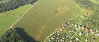
The exact boundaries of an object can be determined using a procedure called site breakdown. This type of work is needed when the client wants to determine the exact area of the site. In order to avoid conflict situations with neighbors, it is necessary to carry out the outlining of points in time.
When designing any object, it is necessary to carry out a breakdown of the site. Setting boundary points makes it possible to determine the size, shape and boundaries of the site. At the time of work, the construction is also linked to communication boundaries and the transport network.
Where to contact
So, it turned out that the procedure was necessary. Where to turn? This question is quite natural, but can be easily resolved, especially in the modern world, where search opportunities are not limited to viewing advertisements in newspapers.
To restore the boundaries of a land plot, contact any geodetic company. You can find them either on the Internet or through advertisements in reliable sources. Of course, before you pay them money, you need to check their license for this type of work, and then fill out an application form.
Citizens also contact the MFC. Land surveying is ordered there in order to be absolutely sure that the delimitation of areas will be carried out by professionals. This organization has information about cadastral engineers who have the right to carry out such work. This is one of the most reliable options since it is still an official organization.
The boundary can be made directly by the person who has the right to land use in relation to this site. It is necessary not only to check the licenses, but also to compare the services offered with the rest of the market, so as not to encounter licensed hacks. There is a danger that everything will not be done very well, without modern technologies, and therefore inaccurately, and the measurement will take place almost along the neighbor’s fence. It seems that there is nothing terrible here, but in the future this can lead, firstly, to conflicts with neighbors due to misunderstandings, and secondly, to the fact that the plot may not be the same area and shape on the plan as it is there actually is.
When the boundaries are taken into account
- In this case, if there are no objects nearby to which turning points can be attached. This is a common situation when a huge area is cut into several sections. When selling, marks are made on the site with pegs, but later they may get lost. Knowledge of the exact boundaries is required including for the construction of a fence, as well as a house, other structures and communications;
- Conflict situations with neighbors over border issues. If there is any doubt about the seizure of your land by a neighbor, drawing up an act of removing the boundaries of the land plot in kind will help resolve the issue. Once you know the boundary points of the memory, you will be able to defend your case. Taking measurements yourself using a tape measure will not yield anything, since this has no legal significance. Measurements can only be carried out by a professional with the appropriate education and licenses. Only an act drawn up by a cadastral engineer can help resolve a boundary dispute;
- Transactions with the site. When carrying out legal transactions (purchase, sale of land plots), taking them into kind will help confirm the coincidence of actual and cadastral ones. Otherwise, boundary disputes with neighbors may arise.
If there are disputes regarding the boundaries of the site, it is better to contact a cadastral engineer. "Cadastral Bureau - Real Estate" is the company that will provide a highly qualified professional to draw out boundaries in kind. Our engineer will do all the work perfectly, and you will not have any problems in the future on the site.
Price
Work on the removal of points is carried out by specialized companies that have on their staff experts with appropriate education and narrow qualifications.
Due to the fact that geodetic services are very complex and require deep knowledge, the cost of the work is high.
How much it costs to determine boundaries on site depends on several factors:
- number of turning points: the more there are, the lower the price;
- square;
- urgency of service provision;
- prices set by a specific company;
- location of the site, including the region of Russia;
- completeness of information available to the owner.
Taking into account all the listed factors, we can conclude that the cost ranges from 500 rubles to several thousand per boundary sign.
Thus, in the Moscow region, installing four boundary signs costs about 9 thousand rubles. Preparation of additional documents is paid separately. These include photographic recording of the boundaries, a conclusion, a report.
Structure and content of the document
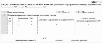
a professional develops an act of setting out the boundaries of the site and a technical report (an indispensable investment). The certificate contains the following data:
- Information from the City Real Estate Cadastre about the site;
- Information about the owner of the site and neighbors;
- Data on measurement methods;
- Type and number of points taken into nature during the work;
- Attachments to the document;
- Customer signatures;
- Seal and signature of a cadastral engineer or surveyor engineer;
The technical report includes text and graphic parts, with attached attachments. The main sections are:
- Location of the site;
- Geodetic information;
- Coordinate system for measurements;
- The basis for the breakdown of the site;
- Description and scope of research;
- Information about the contractor;
- Methods and equipment for work;
Having completed the technical documentation, the professional certifies it with a signature and seal (seal of the organization). After which the act of removal comes into legal force.
professionals are members of SROs who have qualification certificates. The company's engineers regularly increase their knowledge and skills. This confirms the highest level of work performance.
Boundary signs
When staking out the locations of turning points, it is necessary to establish boundary symbols. The symbols can be a rebar bar or a concrete pillar. This can be a specially mounted reinforcement bar or a minimal concrete column. The introduction of poles or wooden pegs is also likely.
If the marked point disappears, the section must be laid out again. Therefore, it is better to ensure their safety. This will help avoid problems with neighbors.
How to take out in kind
To carry out out-situation, you first need to enter into an agreement with a cadastral engineer. You won't need a huge package of documents. Your application is required to carry out the work. Engineers carry out work based on an extract from the Unified State Register of Real Estate. You can get a certificate from Rosreestr yourself, or ask for support from the employees of the Cadastral Bureau - Real Estate (the extract is included in the value of the service).
When registering a land plot, information about the boundaries and coordinates of turning points is added to the register. This data, as well as a schematic plan of the site, is contained in the extract.
Engineers determine the location of turning points on the ground using geodetic equipment. When a turning point is established, it is marked with a boundary sign. After the work, the customer inspects their compliance.
Removal bases
The basis is considered to be the documented legal capacity of the owner or other title holder of the land plot who needed to restore the boundaries of the land. These may include:
- realtors putting up land for auction;
- owners - sellers of the site;
- neighbors between whom a dispute has arisen;
- persons reorganizing the memory;
- bona fide owners planning the distribution of development zones.
Legal capacity is confirmed by submitting proof of title to the cadastral engineer.
Situations often arise when undemarcated lands are surrounded by a fence or a permanent structure begins to be erected. As a result, an overlap of boundaries is revealed, which regulates the termination of unauthorized activities and the liquidation of work results on the basis of Article 7.1 of the Code of Administrative Offenses of the Russian Federation.
Preparation of the act of drawing out boundaries in kind
Stages of site breakdown:
- Preparation – analysis of documents by a professional, selection of methods and equipment for performing the work;
- Field stage - installation of boundary symbols on the ground;
- The final stage is the preparation of a report.
To top it all off, a Take-Out Certificate is drawn up. This act comes in several types. The form of the act depends on the customer’s requirements and the specifics of the project.
Simple
This act can be done directly on the site. The expert determines the basis for installing boundary symbols. The act also contains information about the land plot and its owners. This helps in identifying the object. There is no serious form for drawing up an ordinary act. It is made in two copies: for the customer and the contractor.
This act is not necessary for disputes with neighbors. Its minus is low information content. When boundary disputes arise, it may seem that the act was not drawn up by a professional. Doubts will also arise about the sincerity of setting boundary symbols according to the coordinates noted in the register. Since the professional is not responsible for the safety of the installed symbols. Signs may be lost or moved. Confirm clearly established signs according to the act. It may be necessary to take it out again in the presence of neighbors.
With photo report
In this act, in contrast to the usual act, there is a photographic recording of boundary symbols. This act shows the installation of boundary symbols and their location. This act can help resolve controversial situations in boundary issues. The expert creates it at the final stage of work. The help includes several parts.
The explanatory note contains information about the land plot, its owner, company and executor. The essence is similar to a simple act. The explanatory note is supplemented with a schematic representation of the turning points of the boundaries and photographs of the boundary points. The photographs should reflect the numbers corresponding to the extract from the Unified State Register of Real Estate. These documents allow you to prove that you are right. This act also has shortcomings, because the photo does not allow one to establish a clear approximate distance. This is clearly expressed in areas located far from serious objects.
With binding scheme
The best option to prove that you are right. Its main advantage is the existence of a complete scheme. The diagram reflects boundary signs, as well as monumental objects located at a distance of 20 meters from the boundaries. The exact distance is indicated from all boundary points to the boundaries of such capital objects. This is a document with complete information. The explanatory note contains all the necessary information about the site. The photo report confirms the installation of boundary symbols. The diagram reflects the placement of boundary symbols and the distance from them to serious objects.
If a boundary mark is lost, it can be restored using a tape measure. This act can be used in court in case of boundary disputes with neighbors. Unlike the two previous forms, this act contains additions. It contains information about the self-regulatory organization that helps perform this type of work, and the results of constant verification of geodetic equipment. This type of act has major advantages over simple ones. However, it also has disadvantages. The absence of serious objects nearby makes it impossible to attach a boundary sign.
Engineers are happy to help you with drawing out the boundaries of the required area. Our professionals will carry out field work and draw up a report in the required form. The act with the binding scheme contains more information, but its preparation is not always required. Our specialists will advise you on what form will be needed for your case. We will be happy to help you and answer all your questions!
How to draw up an act correctly
There are not yet any regulatory documents that would determine the form and structure of the Act. Therefore, when compiling it, cadastral engineers can use various forms.
The simplest form of this document can be an acceptance certificate for the location of boundary marks (MS).
In such a document you must indicate:
- reasons for applying for removal work;
- customer data;
- storage location;
- the layout of the MH and their shape (pegs or long-term signs).
The act is executed in 2 copies and sealed with the signatures of the contractor and the customer. One copy is given to the customer, and the second to the contractor. Graphic materials or technical reports may be attached to the Act.
In case of disputes with neighbors, an executive drawing may be attached to the Act, which indicates the actual area of the land plot, as well as the unauthorized area.
The act may also indicate the terrain and real estate objects.
Measurement error during staking out
When carrying out boundaries in situ, an error of 5-30 cm is allowed. An extract from the Unified State Register of Real Estate makes it possible to see the accuracy. Accurate measurements are provided by modern geodetic equipment. Most often, the error is no more than 5 cm. The accuracy of measurements is most influenced by the equipment used in the work of the engineer. Employees of the Cadastral Bureau - Real Estate use their own equipment, which is tested and has the necessary licenses, which guarantees minimal errors in measurements.
What documents need to be prepared?
Documents required to perform work on determining boundary symbols:
- Statement of the established form, on the basis of which the work is carried out;
- Extract from the Unified State Register of Real Estate;
- Passport;
- Documents confirming land ownership;
- Urban development plan of the site (if available).
To obtain or re-receive the above certificates, it is better to contact specialists ☎
What is the deadline for the work?
Installation of boundary signs
Typically, survey engineers use satellite technologies, which are most often combined with conventional boundary determination methods. As a rule, one day is enough for such a procedure. The work is quite fast and does not require special manipulations. However, engineers may be busy, so it is worth contacting in advance. Also, if you want not just an act, but a photo report, or an act with a link, then this will take more time. As a result, you get high-quality work on setting boundaries, drawing up an act, as well as established boundary signs.
If you take an ordinary site with four boundary signs, then the entire work will take from half an hour to an hour and a half. It all depends on how dense the building is and whether there are trees nearby.
The final work may take from 1 to 4 days.