The land survey plan appeared quite recently, as a replacement for the cadastral passport.
It has a similar structure and is regulated by Federal Law 218-FZ of 2015 “On State Registration of Real Estate”.
The plan contains information that is entered into the EGRN (Unified State Register of Real Estate).
This means that all data about the territory that is entered into the Rosreestr database is presented in this document.
General plan objectives
Although you can do whatever you want on your own land, there are mandatory requirements, the implementation of which is monitored by architectural supervision and self-government bodies. They are taken into account in the general plan, which is drawn up before the site is designed.
Document development solves the following problems:
- coordination of the development project with government agencies and obtaining permission to develop the plot;
- rational distribution of objects on the territory (residential building, outbuildings, swimming pool, garden, playground, garage, etc.) taking into account the relief, climatic and other features of the area.
The drawings show a technically competent and safe communications layout, as well as the correct and convenient location of buildings in accordance with fire safety and sanitary standards.
Where and how to get it?
To obtain a cadastral plan, you need to contact the MFC or Rosreestr. You can visit the organization’s office in person by taking a paper form from an employee and entering the name of the sender and recipient, storage data, purpose of receipt, and the required number of copies of the document. The finished plan can be picked up after 5 days if you contact Rosreestr and after 5 days - at the MFC, upon presentation of your passport and receipt of payment of the state duty for each copy.
The application can also be submitted through the website https://rosreestr.ru/. You can find it at the link https://rosreestr.ru/wps/portal/p/cc_present/EGRN_6. Any interested person has the right to submit a request for a copy of the document. We talked about how to get a cadastral plan by number online here.
Reference! The price of the paper version of the cadastral plan is 800 rubles. for individuals and 2400 rub. for YUL. The cost of a document in electronic form is 150 rubles. for individuals and 300 rub. for YUL.
Every land owner has to deal with a cadastral plan. Without it, it is impossible to legally complete any real estate transaction. Obtaining a document is simple - just contact the MFC or Rosreestr, fill out an application and pay the state fee.
Components of a master plan
When drawing up drawings and plans, it is important to take into account as many details as possible. This will help eliminate serious mistakes in the development of the territory, the construction of capital structures and their operation. The likelihood of land disputes will also be reduced. For this purpose, other documents are additionally developed in addition to the general plan:
- situational plan — location of the allotment within the settlement, region;
- reference plan - a diagram showing the existing buildings on the site, water and gas pipeline networks, electricity, as well as places where tall trees grow;
- utility network diagram - shows how it is planned to connect communications to the plot, if they do not exist, as well as the points of their entry into the buildings;
- vertical site layout diagram — elevation marks at different points of the territory, volumes of earthworks to prepare the site for construction.
The formation of a general plan helps to determine the relationship of the house with respect to the cardinal directions, red zones, site boundaries, and to choose the best place for the entrance, outbuildings, and garden layout. It is important that all the features of the plot are taken into account - shape, size, species potential, soil, relief and others.
What is a land plot layout
A land plot location diagram (LPL) is a document that represents a plan of the boundaries of the created plot or redistributed territories. Approved by authorized officials and is a graphical annex to the order of the body responsible for the distribution of land resources
. The diagram contains a description of the location of the site. It determines the specific location of the plot on the ground (coordinates), as well as the area and configuration of the boundaries of the allocated territory.
Features of drawing up a master plan
The success of planning depends on compliance with certain requirements:
- do not build houses or plant trees in areas where communication systems pass;
- maintain distances between all objects on the site, which are regulated by fire safety rules and sanitary standards;
- do drainage on wet soils;
- on uneven plots with slopes, build the house on a hill.
The master plan gives a clear idea of what will be located on the territory and where.
Input data for the plan
The development of the project is carried out on the basis of the urban planning plan of the site, geological studies of the area and topographic and geodetic surveys.
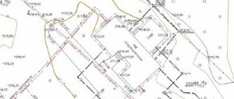
Topographic plan of the land plot
Before drawing up drawings, an analysis of the area is carried out, studying:
- terrain, soil composition and groundwater depth;
- location of cardinal directions, illumination of different parts of the plot, wind direction;
- shape, size of the territory, its specific points.
Preliminary work is necessary to accurately determine the boundaries of the plot, roadways and pedestrian parts of roads and other terrain parameters that affect planning.
Scale and principles of construction
The main part of the general plan is a drawing of the designed site, graphically superimposed on the topographic plan of the area. It is carried out on a scale of 1:500, taking into account existing red lines, utility networks, roads, structures and environmental facilities. It indicates the prevailing wind rose and cardinal directions in winter and summer.
Typically, the long side of the plot is located along the long side of the construction sheet and the northern part of the plot is at the top. The axes correspond to the sides of the sheet and in accordance with them the contours of all structures and objects are drawn. Drawings are made in accordance with GOST 21.508-93 SPDS.
What is it needed for?
Each land property must be registered in the Unified State Register of Real Estate , where it is assigned an individual cadastral number. For this procedure, the owner must provide a package of documents, including a cadastral plan of the land plot.
Without a document it is impossible to carry out transactions with land:
- registration of encumbrances (how to find out the presence of encumbrances by cadastral number?);
- acquisition;
- sale;
- transfer of rights by gift;
- rental.
The cadastral plan is the basis for state registration of real estate. The status of the memory and its characteristics, for example, cost, depend on the correctness of its preparation.
The functions of a document depend on its type:
- The boundary plan consists of two blocks: text and graphic. It is necessary to register the land in the cadastral register and assign it a service cadastre number. The paper is drawn up during land redistribution: separation or unification of territory, adjustment of boundaries and errors made in official documentation.
- The technical map also consists of two parts. The graphic part contains diagrams and drawings, and the text part contains the characteristics of the memory and information about its location.
- In the derived map you can find information about the territory as a whole, indicating social, natural and economic processes.
- The public plan is posted on the Internet so that everyone has the opportunity to find information about the land plot at its address.
- The duty card reflects data on the territorial zone of the storage facility's location. The information is presented in the form of diagrams and text blocks.
Tips for zoning areas
When drawing up a master plan, it is advisable to divide the site into functional zones, which are conventionally divided into:
- residential - any buildings where the family will live;
- household - household buildings, workshops, animal sheds, compost pit, bathhouse, etc.;
- relaxation - places for relaxation, games and entertainment, for example, a playground, barbecue, decorative corners, swings, gazebo, swimming pool;
- green - garden, vegetable garden, greenhouses, greenhouses;
- entrance - entrance to the site and passage to the house, garage.
To rationally use the territory and create a comfortable and practical space, it is important to take into account the following planning principles:
- start work by choosing a location for a residential building and from there, divide the territory into zones;
- economic facilities should be located further from the red line, and all buildings should be located on the northwestern or northern side to protect the area from the wind, but maintain sufficient illumination;
- on elongated plots, outbuildings and sheds with animals should be located separately from the residential building;
- maintain unity of style when landscaping the territory.
In areas of different sizes, zoning has its own characteristics.
General plan options for plots of different sizes
If the territory is small, for example, 6 or 8 acres, then in addition to a residential building you can place the following buildings on it:
- toilet, shed and other household objects - 15 m2;
- garage or parking space - 8 m2;
- vegetable garden and greenhouse - 120 m2;
- play area and place for games - 75 m2.
There is also enough space on the site for planting flower beds and flower beds and laying garden paths. Typically, plots of this size are used as summer cottages. Therefore, little space is allocated for the house. Cherries, pears, plums and other fruit trees, as well as berry bushes, are planted in the free area.
On 10 or 12 acres it is already possible to place more objects, for example, build a swimming pool, a gazebo in the relaxation area, and allocate space for a barbecue and barbecue. There are also more opportunities for landscape gardening and zoning.
General plan of a plot of 10 acres
Even more objects can be located on an area of 15, 20 acres. When developing a master plan, you need to highlight an entrance area with a garage, located further from the residential building, but with convenient access to it. You can add a veranda to the house or make a terrace and an attic. Usually a place nearby is allocated for a recreation area, sports and children's playgrounds. And decorative landscaping is carried out using fountains, alpine slides, garden figurines and other elements.
Without the development of a master plan, construction cannot be carried out on the site. Therefore, it is important to draw it up in accordance with all requirements and mandatory standards. But we must not forget about the comfort and visual attractiveness of the territory. It should be liked by those who will live and relax there.
dizlandshafta
What types are there
Order of the Ministry of Economic Development No. 72 defines the types of drawing up schemes. SRZU are necessary for:
- redistribution of land - a share of the territory is allocated for private ownership;
- the emergence of a new site;
When redistributing land, the SRZU indicates the previous territory and the part that is planned to be annexed. When allocating a new plot, only the plan of the land being formed is included in the document.
Sample - Layout diagram for increasing the area
How to check the quality of services performed by a survey specialist
In other words, how can you make sure that this or that engineer needs to be hired to work with a certain area, so as not to encounter the errors that were written about earlier?
- First of all, you need to make sure that the cadastral specialist is qualified. Qualification will be indicated by the presence of a certificate from a specialist.
- Before concluding a contract, you need to obtain information about a geodesy specialist; this can be done on the Rosreestr website.
- It must be remembered that the activities of engineers in this area are strictly controlled by the relevant government agencies to which they are responsible. They also certify a specialist and test him in a qualification exam.
The most complete information about surveyors is recorded in state registers.
If such a specialist contributes to the introduction of deliberately false information into the text of the documentation, then at best he will face a fine of 5,000 rubles and disqualification for a period of 3 years. All actions of the engineer within the framework of the contract for carrying out all stages of the work can be challenged in the manner prescribed by the legal system.
Let the owners of the plots decide for themselves whether they need land surveying or not. But still, the answer here will be unambiguous and definitely not negative. “The law is harsh, but it is the law,” so the owners are forced to obey its demands, contrary to their previous ideas.
Who approves the SRZU for CPT and within what time frame?
SRZU is approved by the executive body of state power or local government body with municipal ownership of land. A decision on approval or refusal is issued within 30 days from the date of submission of the application.
After making a positive decision, the authorized body must, within 5 days, send it to the rights registration authority using electronic, interdepartmental communication systems. The validity period of the decision is 2 years from the date of its issuance (Clause 15, Article 11.10 of the Land Code of the Russian Federation).
Challenging refusals
The local administration does not indicate a specific list of violations in the formation of the scheme - the customer finds and corrects such errors independently. For example, registration may be refused due to the absence of accepted symbols and landscape features on the diagram, etc. For comparison, you can order a diagram from a cadastral engineer and compare the inaccuracies. If none are found, the refusal can be appealed.
First, you should write a letter asking to explain the reasons for the refusal to approve the SRZU with a request to provide links to laws or decisions made that are publicly available. The answer comes within a month. Based on the explanation received, the indicated corrections are made to the diagram and sent for approval again. The administration does not have the right to finally refuse approval of the scheme, but during the consideration of the issue, the site may be transferred to another.
They refuse to register a plot for their own reasons. Sometimes pieces of land are “held” as their own, citing various circumstances. The customer is bombarded with replies for years until he no longer claims the land or the land is transferred to another person. Sometimes several owners apply for a site, and the authorities select future owners at their discretion. The priority of submitting the scheme does not matter in this case.
If this happens, the first step is to file a claim against the refusal received. If no response is received or the reasons for the refusal turn out to be unconvincing, the case is considered in court.
Reasons for contacting law enforcement:
- unreasonable refusal to consider the SRZU;
- denial of consideration based on laws or regulations that have lost legal force;
- unreasonable delay in the approval of the scheme.
In these cases, the actions of officials are challenged by writing complaints to the prosecutor's office or contacting a lawyer.
The procedure for land surveying
If you want to determine the boundaries of your site, you must contact the Department of Architecture and Urban Planning or resort to the services of private organizations or cadastral engineers acting as individual entrepreneurs.
Once you have made your choice and made sure that the specialist has a current license to carry out this type of work, you need to conclude an agreement for the provision of services. The contract must specify the timing and cost of the work . It must be remembered that this process can take from two weeks to one and a half months.
After signing the contract, you will need to hand over a package of documents to the specialist and agree on a date for organizing the survey.
Next, your task is to notify the owners of the plots with which your plot borders of your intention to carry out land surveying . Do this at least 7 days before the date of determining the boundary of your site. Ask them to be present on the appointed day and time. Choose any written notification method: hand it in person, send it by Russian post or e-mail with a request for confirmation of reading, pay for a note about the planned event in a local print publication.
On the agreed day, a specialist will come to your property to carry out land surveying. After the work is carried out, an act of approval of the location of the boundaries of the land plot is always drawn up.
The act is certified by the signatures of the customer, that is, the owner of the land , the owners of adjacent land plots, the cadastral engineer who performed the measurements, a representative of the local administration (the organization performing the survey must take care of his presence), as well as the chairman of the gardening partnership (if the measurements will be made in it) .
If any of the parties does not agree with the results of determining land boundaries, then the act should reflect how the differences will be resolved.
Then you just have to wait until the company with which you entered into an agreement prepares the project within the agreed period.
Attention! If after the land survey the boundaries of your plot have changed, you must notify the land committee. Take the technical passport there for approval.