General plan objectives
Although you can do whatever you want on your own land, there are mandatory requirements, the implementation of which is monitored by architectural supervision and self-government bodies. They are taken into account in the general plan, which is drawn up before the site is designed.
Document development solves the following problems:
- coordination of the development project with government agencies and obtaining permission to develop the plot;
- rational distribution of objects on the territory (residential building, outbuildings, swimming pool, garden, playground, garage, etc.) taking into account the relief, climatic and other features of the area.
The drawings show a technically competent and safe communications layout, as well as the correct and convenient location of buildings in accordance with fire safety and sanitary standards.
Issuance of an urban development plan for a land plot
The regulatory framework for issuing a town planning plan to an applicant is enshrined in the Town Planning Code of the Russian Federation N 190-FZ, Article 55. All information about how the service is provided and the result is produced must be present on the administration’s website or a stand in its premises. In order for a legal entity or individual to obtain a document, you will need to contact the local government authority (the administration of the settlement to which the land plot belongs) with an application and a package of documents.
Deadline for issuing GPZU
The regulations specify a period for the preparation, coordination and approval of the plan; it is no more than:
- 30 working days - in the regions;
- 20 days - in Moscow.
A similar procedure applies to land under individual housing construction. In this case, the type of permitted use is indicated in a certain column of the document form:
- for individual housing construction;
- for running private household plots, if there is the possibility of constructing a residential building.
Price
There is no fee charged to the applicant for the preparation and issuance of an urban development plan. The law establishes that local authorities provide this service free of charge.
Refusal
Refusal to issue a plan occurs extremely rarely and for good reasons. This may happen if not the entire list of documents required for this procedure is provided, or if it is impossible to read the text of the documents. Therefore, you should first carefully select and check all the papers.
Validity
The information contained in the GPZU can be used for three years for:
- obtaining a construction permit;
- preparation of project documentation.
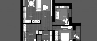
Components of a master plan
When drawing up drawings and plans, it is important to take into account as many details as possible. This will help eliminate serious mistakes in the development of the territory, the construction of capital structures and their operation. The likelihood of land disputes will also be reduced. For this purpose, other documents are additionally developed in addition to the general plan:
- situational plan — location of the allotment within the settlement, region;
- reference plan - a diagram showing the existing buildings on the site, water and gas pipeline networks, electricity, as well as places where tall trees grow;
- utility network diagram - shows how it is planned to connect communications to the plot, if they do not exist, as well as the points of their entry into the buildings;
- vertical site layout diagram — elevation marks at different points of the territory, volumes of earthworks to prepare the site for construction.
The formation of a general plan helps to determine the relationship of the house with respect to the cardinal directions, red zones, site boundaries, and to choose the best place for the entrance, outbuildings, and garden layout. It is important that all the features of the plot are taken into account - shape, size, species potential, soil, relief and others.
Documents for obtaining GPZU
The complete list of documents required to obtain a town planning plan is not established by law. Therefore, there is no unambiguous list and the territorial authority has the right to establish it independently.
Documents for obtaining a GPZU in Moscow: passport (if you have a power of attorney) and title documents for the land plot and the house. To apply, you will need to go to mos.ru and fill out an application in the online form.
Instructions on how to obtain a town planning plan in Moscow and the Moscow region for legal entities and individuals - open.
An approximate set of documents for other regions includes:
- application of the interested person in the form approved by the administration;
- passport of the applicant or an authorized person acting under a notarized power of attorney;
- extract from the Unified State Register of Land Registers for the land plot;
- special technical conditions for a capital construction project;
- topographic plan - a snapshot of the plot with all ground, underground and above-ground objects, including communications;
- situational plan;
- special technical conditions for a capital construction project;
- boundary plan;
- If there is a permanent structure on the site, in order to draw up an urban planning plan for the plot of land, you will need to provide a technical passport of the structure.
- topographical photograph of the allotment with all ground, underground and above-ground objects, including communications.
The list of documents can be supplemented by order of the local government to clarify the data on the land plot.
Often, an application form is used on the city administration website, in which you need to enter all the necessary data. The document is drawn up in two copies, one of the copies with a mark remains in the hands of the applicant.
There are several ways to apply for a plan. Just choose the most convenient one from the following:
- personal appeal of the applicant;
- through an authorized representative;
- by postal mail with a package of documents attached according to the inventory and sent by registered mail with notification (it contains a receipt mark, which will be evidence of receipt of the papers by the authorized body);
- transfer a package of documents through the multifunctional center;
- submit through the public services portal (not all territorial authorities have yet joined the electronic services system in terms of receiving urban planning plans).
To prepare the GPZU, the territorial authority, within 7 days from the date of receipt of the documents, sends requests to operating organizations about the possibility of connecting the planned construction or reconstruction facility to the utility networks. Technical specifications are prepared and submitted to the department.
Features of drawing up a master plan
The success of planning depends on compliance with certain requirements:
- do not build houses or plant trees in areas where communication systems pass;
- maintain distances between all objects on the site, which are regulated by fire safety rules and sanitary standards;
- do drainage on wet soils;
- on uneven plots with slopes, build the house on a hill.
The master plan gives a clear idea of what will be located on the territory and where.
Input data for the plan
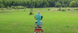
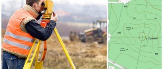
The development of the project is carried out on the basis of the urban planning plan of the site, geological studies of the area and topographic and geodetic surveys.
Topographic plan of the land plot
Before drawing up drawings, an analysis of the area is carried out, studying:
- terrain, soil composition and groundwater depth;
- location of cardinal directions, illumination of different parts of the plot, wind direction;
- shape, size of the territory, its specific points.
Preliminary work is necessary to accurately determine the boundaries of the plot, roadways and pedestrian parts of roads and other terrain parameters that affect planning.
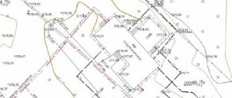
Scale and principles of construction
The main part of the general plan is a drawing of the designed site, graphically superimposed on the topographic plan of the area. It is carried out on a scale of 1:500, taking into account existing red lines, utility networks, roads, structures and environmental facilities. It indicates the prevailing wind rose and cardinal directions in winter and summer.
Typically, the long side of the plot is located along the long side of the construction sheet and the northern part of the plot is at the top. The axes correspond to the sides of the sheet and in accordance with them the contours of all structures and objects are drawn. Drawings are made in accordance with GOST 21.508-93 SPDS.
New conditions for registration of GPZU
Since 2021, changes have been made to the GPZU format, as well as new conditions for obtaining the following content:
- After the signing of the law on the need to notify the administration about the start of construction, the procedure for ordering a GPZU changed; now it is not necessary to submit a topographic plan to the list of documents.
- As of July 1, 2021, only the copyright holder can request a plan. Previously, such a right was granted to any interested party.
- The GP of the land plot must indicate the boundaries of the plot with cadastral registration coordinates and information about town planning regulations.
- A new term has been introduced into the Town Planning Code - integrated and sustainable development of the territory. This means providing a given territory with a full range of engineering, transport and social infrastructure and addresses this provision to objects of any purpose, not just residential. Such territories must be designated in the rules of land use and development of settlements, and for them, when preparing an urban planning plan, information must be indicated that is extracted from urban planning standards.
These requirements and format are established and reinforced, in addition to the Town Planning Code, by order of the Ministry of Housing and Communal Services, effective in 2021.
Tips for zoning areas
When drawing up a master plan, it is advisable to divide the site into functional zones, which are conventionally divided into:
- residential - any buildings where the family will live;
- household - household buildings, workshops, animal sheds, compost pit, bathhouse, etc.;
- relaxation - places for relaxation, games and entertainment, for example, a playground, barbecue, decorative corners, swings, gazebo, swimming pool;
- green - garden, vegetable garden, greenhouses, greenhouses;
- entrance - entrance to the site and passage to the house, garage.
To rationally use the territory and create a comfortable and practical space, it is important to take into account the following planning principles:
- start work by choosing a location for a residential building and from there, divide the territory into zones;
- economic facilities should be located further from the red line, and all buildings should be located on the northwestern or northern side to protect the area from the wind, but maintain sufficient illumination;
- on elongated plots, outbuildings and sheds with animals should be located separately from the residential building;
- maintain unity of style when landscaping the territory.
In areas of different sizes, zoning has its own characteristics.
General plan options for plots of different sizes
If the territory is small, for example, 6 or 8 acres, then in addition to a residential building you can place the following buildings on it:
- toilet, shed and other household objects - 15 m2;
- garage or parking space - 8 m2;
- vegetable garden and greenhouse - 120 m2;
- play area and place for games - 75 m2.
There is also enough space on the site for planting flower beds and flower beds and laying garden paths. Typically, plots of this size are used as summer cottages. Therefore, little space is allocated for the house. Cherries, pears, plums and other fruit trees, as well as berry bushes, are planted in the free area.
On 10 or 12 acres it is already possible to place more objects, for example, build a swimming pool, a gazebo in the relaxation area, and allocate space for a barbecue and barbecue. There are also more opportunities for landscape gardening and zoning.
General plan of a plot of 10 acres
Even more objects can be located on an area of 15, 20 acres. When developing a master plan, you need to highlight an entrance area with a garage, located further from the residential building, but with convenient access to it. You can add a veranda to the house or make a terrace and an attic. Usually a place nearby is allocated for a recreation area, sports and children's playgrounds. And decorative landscaping is carried out using fountains, alpine slides, garden figurines and other elements.
Without the development of a master plan, construction cannot be carried out on the site. Therefore, it is important to draw it up in accordance with all requirements and mandatory standards. But we must not forget about the comfort and visual attractiveness of the territory. It should be liked by those who will live and relax there.
dizlandshafta