In the process of drawing up a boundary plan, the engineer, determining the place where the lines will run that will limit the plot and distinguish it from the total area, relies on turning points.
Such points are understood as specific coordinates, after drawing segments between which the boundary of the site is formed .
In any case, carrying out boundary work is impossible without determining the coordinates of the turning points.
In this regard, there is a whole methodology for calculating them and placing them directly at the location of the site.
What it is?
Each plot of land has its own characteristic configuration , and it is not always a clear rectangle with four lines and an angle between them of 90 degrees, as many who are not closely familiar with geodesy and cartography believe.
Even the forming lines themselves, which determine the shape of the site, may not be 4, as is commonly believed, but much more.
At the end of any of the lines forming the boundary, another begins and between them there is a point, which is characterized as a turning (characteristic) point of the land plot.
By imagining a boundary plan or looking at an example of it, anyone can easily determine the location of such turning points between the drawn lines.
Actually, the construction of site boundaries is primarily based on such established points - first, such turning points are determined using various methods, and then the boundaries are designated by simply drawing straight lines between the characteristic designations.
Purpose
The main purpose of turning points is to indicate the coordinates of the boundary lines , that is, a specific indication of where the boundaries will pass.
Based on the documentation provided and the measurements and calculations carried out, the engineer performing the land surveying procedure and completing the survey work determines the coordinates of the turning points and subsequently, drawing straight lines between them, marks the clear boundaries of the site.
That is, there cannot be a reverse process - you cannot first draw lines, and only then mark the boundaries, since the line can be determined by the coordinates of the beginning and end - without such accurate data for each of them, it will simply be impossible to draw the boundaries of the site.
Let's consider how to determine the turning points of the boundaries of a land plot. The coordinates of the points, after carrying out complex calculations, determining the exact values, placing them on the ground and agreeing on the boundaries with interested parties (owners and users of neighboring plots), are established in kind.
That is, in fact, the engineer sets milestones, when drawing lines through which the boundaries of the land plot are formed.
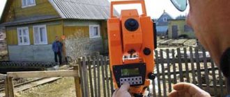
A cadastral engineer with the appropriate qualifications can carry out the determination of the turning points of the site .
Even if the owner of the plot or his neighbor does not agree with the location of the boundary line and believes that their interests are affected, it is impossible to independently move such signs on the plot itself .
To dispute the coordinates, you will need to contact either the organization that carried out the survey (within 30 days) or the judicial authority, if the data on the site has already been entered into the national register.
In case of unauthorized transfer of points in any direction, the person who committed such an action may be held liable and pay the amount of fines required in such cases.
Border coordinates
Considering the concept of coordinates of the boundaries of an allotment, in parallel with this definition, the almost identical “coordinates of boundaries” is used. In accordance with the Federal Law regulating state cadastral activities, any allocated plot is subject to entering data about itself into a single state. registry.
Each of the document forms in which such information is provided may look slightly different, but they all contain data on boundary coordinates .
That is, such plans reflect those characteristic features of information that distinguish them from any other plot anywhere in the world and, in fact, make it possible to determine its location for the direct assignment of property rights.
In fact, the coordinates of the boundaries cannot be established (from a mathematical point of view), since the location and direction of the boundaries of the site are determined by single points, the coordinates of which become the so-called indicator of where the boundary will lie.
Thus, when using the concept of “boundary coordinates,” you should understand that you automatically mean the coordinates of turning or characteristic points.
In addition to the direct coordinates of the turning points of the site, according to the current legislation, when drawing boundaries in nature, additional designations , which are installed on a straight line connecting the characteristic points of the plot.
This requirement exists due to a certain length of straight lines, when due to external factors it can be repeatedly broken.
Such additional designations are placed in the range from 1 to 200 meters , that is, at least every 200 meters a boundary mark must be installed, but at the same time it cannot be located more often than every 1 meter.
Installation of additional designations is also carried out by the cadastral engineer after the approval procedure has been carried out with all interested parties and they have signed the relevant act.
Coordinates of turning points
Coordinates of points are a digital designation of the location of points on the site on the ground, when drawing a line between them a closed figure is formed , defining the boundaries of the plot.
Subsequently, such a closed area
is subject to determination of the area based on the configuration of the site itself and the parameters according to which it is calculated.
The system of activities of the state cadastre includes all data on the boundaries of land plots - they are broadly defined as a geodetic network of lands of the Russian Federation.
The border coordinates themselves, when read by ordinary citizens not familiar with cartography or geodesy, will be of little use.
Their values using specialized codes , and any cadastral engineer with knowledge in this area can easily determine and check the real location of the site on the ground and establish the boundaries between such points, that is, indicate the boundary of a person’s property.
Since the design of the coordinates of turning points is carried out in the form of coded values, and the determination itself is associated with the use of specialized equipment and complex mathematical formulas, the calculation of characteristic points is treated very carefully , constantly improving the methods of their determination, determination, and recalculation.
What can information on the cadastral numbers of a plot give?
If you know the cadastral number of the desired object, then it is possible to obtain the following information from it:
- Territorial number of the district, territory, quarter and affiliation with the Rosreestr body of your land plot.
- Characteristics of the status of the land plot.
- The actual location of the site.
- Total area.
- Cadastral value of land.
- Date of registration, with information about updating data by date.
- Category of land plot.
- Type of permitted land use.
Determination methods
To determine coordinates, engineers who directly carry out the work of creating plans use several methods in the process of work, among which there are five methods that are directly used in the territory of the Russian Federation .
After direct determination, such points, before being transferred to topographic documents, undergo a description procedure in a system of special coordinates, which is provided specifically for cadastral designations.
Geodesic
This method is a combination of the following methods:
- Triangulations . This technique allows you to create a reference network of geodetic points, on which the determination of the coordinates of the turning points of the site is based, between which the boundary is drawn. In principle, the entire network on which the system is built consists of many such triangles, successively adjacent to each other;
- Polygonometry method . It consists of measuring on the ground the lengths of lines that sequentially connect specific points and objects and, in the process of their construction, form a so-called polygonometric code;
- Trilateration method . This method is based on determining the position of geodetic points by constructing a system of triangles adjacent to each other on the ground;
- Serif method . This method is based on determining the coordinates of each individual point by measuring elements that connect its location with individual points.
Satellite geodetic measurements
This method is similar to the geodetic principle, but also includes data on surveying the area via satellites .
In this way, greater accuracy of the measurements is achieved.
The coordinates of turning points or characteristic points obtained by satellite are rarely determined incorrectly.
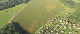
Photogrammetric
This method is based on the use of the cartometric method in the process and the parallel use of aerial photographs , which are brought to the appropriate map scale.
Due to certain aspects of ownership of such images, which somewhat affect property rights, this technique is used quite rarely .
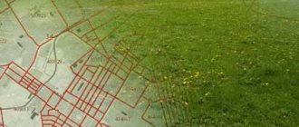
Cartometric
This method is based on the use of cartographic material , that is, topographic maps, city and district plans, which can be created by individual municipalities.
Having calculated the coordinates of the points, the engineer reflects them on such a map, and subsequently, directly reading the map itself, he already determines the direct location of the points and draws out the boundaries of the site in nature.
Analytical
This method, used to determine coordinates, is based on obtaining the results of calculations of the lines and angles of the allotment using special formulas of trigonometry, analytical geometry, etc.
This method is currently widely used and it is most advisable to use it if you have software that ensures the accuracy of the obtained values.
How to find a site by xy coordinates on a map
If you have data from a local coordinate system, then most likely you received it from an extract, which means you have a cadastral number for the land plot. Using the cadastral number, it is easy to determine where exactly the plot is located - you just need to enter it into the search engine of the public cadastral map and you will see not only the location of the land plot, but also its description (address, category of land, cadastral value, area, etc.)
But, if you only have coordinates, then the situation is more complicated.
To find a site using X, Y coordinates, they should be converted to geographic coordinates. To do this, there are a lot of free and paid services for converting coordinates from one system to another on the Internet.
However, keep in mind that the recalculation (especially the free one) will be approximate and the data of such coordinates may have a range of plus or minus a couple of meters, or even more.
If you have the cadastral number of the plot, then you can find its geographical coordinates on the same public page - we wrote detailed instructions on how to do this in a separate article.
In short, move the cursor over the corner of the land plot of interest and click the mouse - the search engine will display the geographical coordinates. See photo below.
Determination accuracy
In the process of calculating coordinates, such a concept as the accuracy of certain coordinates and their error is used.
Considering this concept, it is worth noting that permissible deviations from actual values \u200b\u200bare established by law , which make it possible to use the obtained coordinates as actual points and set them in situ.
The role of accuracy and error
The accuracy of the measurements obtained has a significant impact on the ability to determine the actual boundaries of areas and indicate its characteristic points.
The error that may occur is the difference (difference) between the actual values and those obtained by engineers as a result of the calculations performed.
An error can arise due to various factors , among which it is worth noting the human factor, when the engineer himself makes a mistake.
Also, the magnitude of the error is affected by poor-quality or broken equipment, bad weather conditions during direct measurements, and features of the surface topography of the area relative to which the coordinates are determined.
Permissible errors
According to the provisions of the current edition of the Land Code of the Russian Federation, it is determined that there is such a thing as permissible measurement error, that is, that points obtained within the limit of permissible values can be used to determine the actual boundaries of a land plot. In such a situation, a separate norm can be used for each individual site (its category).
At the moment, the maximum permissible error for lands within the Russian Federation will be :
- Allotments allocated within the city limits - 0.1 meter;
- Allotments on the territory of which dachas, garages, private household plots are located - 0.2 meters;
- Agricultural land – 2.5 meters.
In general, the currently existing measurement methods allow the error value to reach literally up to 0.05 meters .
If they go beyond such limits, but are within the acceptable limits, a boundary plan for such points is still formed .
Accuracy of measuring coordinates of land plots
Regarding the accuracy of measuring the position of the plot, the following should be said: possible errors in the procedure are already calculated by law and may vary depending on the purpose of the territory.
Such factors allow us to say that a land plot owned by a certain owner should have clearly defined boundaries, while plots allocated for agricultural activities and owned by a government agency may have minor errors in the boundaries. Moreover, there is no point in measuring the size of the forest or the length and width of the body of water every season.
You can find out about the error rates and exact dimensions depending on the purpose of the land in one of the paragraphs posted above.
In order to maintain order in the cadastral database, surveyors and engineers are constantly upgrading their equipment and measurement methods. This allows for calculations of boundaries on the ground in accordance with legislative acts. In the work of the latter, software plays an important role, the development of which is carried out by IT engineers from all over the world. In addition to everything, cadastral masters have access to topographic photos from satellites, allowing them to create an electronic database of the entire occupied territory.