Our Cadastral Engineers will conduct a survey of the boundaries of your land plot and prepare, in accordance with the requirements of current legislation, a Boundary Plan for forming or clarifying the boundaries of the land plot for an apartment building (MCD).
Description of service:
Preparation of a boundary plan for the formation or clarification of the boundaries of a land plot of the territory of an apartment building (MKD) - this is cadastral work necessary for entering information about the actual location of the land plot boundary in the Unified State Register of Real Estate (USRN), a reliable source of information about real estate objects in the territory Russian Federation.
The territory of a multi-apartment residential building (MDB) is a land plot on which the MKD itself and the adjacent territory are located with elements of improvement and landscaping within the framework of the current cadastral registration and the approved project for planning and land surveying of the area. The owners of premises in an apartment building (AMD) currently have the right to initiate the formation of the boundaries of such a land plot and subsequently dispose of it within the framework of current legislation.
Cases when you need the service of a cadastral engineer to prepare a boundary plan to form or clarify the boundaries of a land plot under an apartment building (MCD).
- You cannot find the boundaries of your land plot on the public cadastral map;
- You have received an appropriate recommendation from government authorities on the formation of a land plot for an apartment building (MKD)
- You don't find it in section 3.2. Extracts from the Unified State Register of Real Estate (USRN) of information on the mean square error in determining the coordinates of characteristic points of the boundaries of a land plot;
- You do not find in section 1 of the Extract from the Unified State Register of Real Estate (USRN) information about the error in determining the accuracy (+/-) of the area of a land plot.
Heading
50 Average project implementation period
Heading
50 Number of completed projects
Heading
50 Average project cost
Calculate the cost of the work and receive a commercial offer on our website. Discount if the contract is concluded no later than 10 days from the date of settlement.
Get advice from a cadastral engineer. Describe your situation and we will help solve your problem.
What is land surveying
Land surveying is the official establishment of the boundaries of a land plot, their fixation on the territory, calculation of the area of the resulting plot with the entry of all data into a single database.
As a result of all manipulations, the customer receives a boundary plan of the site.
Until the site is demarcated, there may be disputes between neighbors about the boundaries of plots, migration of fences and other everyday joys. But if information about boundaries and coordinates is already in the register, such amateur activity is simply impossible.
For new buildings, the issue of surveying the land plot on which the apartment building is located is not relevant. The developer resolves this issue at the stage of handing over the house, because without land surveying it will not be possible to put the house into operation.
Old-built apartment buildings are in most cases located on municipal or state territory. In this regard, they do not have the right to dispose of the land plot at their own discretion, and the management organization cannot engage in landscaping of courtyards. But other interested parties can receive this right, and, as mentioned above, use the territory for their needs.
If the residents of an apartment building wish, they can determine the boundaries of the land plot owned by it and, within the territory, arrange the space in accordance with their needs. At the same time, the allocation of separate plots for each apartment owner is impossible and illegal, even despite land surveying.
During the land surveying process, it is also not prohibited by law to annex adjacent areas that are not registered to anyone. Therefore, residents of neighboring houses can officially increase their local area at the expense of the neighboring undemarcated plot. In this connection, it is better to hurry up in the matter of obtaining a plot of land into the common ownership of residents.
Similar services
Boundary plan for the formation of a land plot Formation of a boundary plan for registration of a land plot with cadastral registration or formation of a land plot
More details
Formation and registration of ZOUIT of real estate objects Preparation of documents necessary for entering information about ZOUIT (zones with special conditions for the use of the territory) into the state real estate cadastre.
More details
Removing the boundaries of the plot Removing the boundaries of the land plot
More details
Topographic survey Topographic survey of land plots
More details
Layout of the land plot Preparation of the layout of the land plot. Our cadastral engineers will carry out all necessary work in accordance with the requirements of current legislation.
More details
Cadastral examination Preparation of an expert opinion of a cadastral engineer
More details
Technical report on the location of the object Preparation of a technical report from a cadastral engineer on the location of the object
More details
Correcting a registry error Preparing a boundary plan to correct a registry error
More details
Redistribution of land plots Preparation of a boundary plan for the redistribution of land plots
More details
Division of a land plot Preparation of a boundary plan for the division of a land plot. Work necessary to form two or more plots of land from one original plot.
More details
Consolidation of land plots Preparation of a boundary plan for the consolidation of land plots
More details
Clarification of the boundaries of the plot Preparation of a boundary plan to clarify the boundaries of the land plot
More details
Who should carry out land surveying?
Since the land on which an apartment building is located is in most cases municipal, in accordance with current legislation, an application for land surveying can be submitted by both the municipality and the residents of the building.
After holding a general meeting of residents of an apartment building, the elected representative can contact the relevant department of the local mayor’s office with the original minutes of the meeting and all related documents. The mayor's office must accept the documents, but the current budget may not include the costs of such procedures. Therefore, the land surveying process can last for months until the municipality finds funds to carry out all the necessary work. And given the current economic situation, and the fact that the country’s city budgets are mostly deficit and subsidized, this may not happen at all.
If the owners do not want to wait, they can invite a specialist to survey them themselves. In this case, all costs associated with the registration of the land survey are borne by the customer (that is, by the residents of the apartment building). It will not be possible to reimburse costs incurred.
That is, there is a choice here - long and free, or paid and faster. It won’t work out very quickly in any case; we’ll tell you why later.
How land surveying of an apartment building will be carried out in 2021 - new law
The law on the extension of the dacha amnesty, dated 08/02/2019 No. 267-FZ, raised the issue of preparing a project for surveying a land plot for apartment buildings. As State Duma deputies explain, the adoption of the law will serve the purpose of stimulating the involvement of residential real estate in civil circulation and will have a positive impact on the dynamics of development of the private residential sector. At the same time, the obligation to carry out all the necessary actions for cadastral registration of the local area (preparing a project for land surveying and a boundary plan for the land plot of an apartment building, applying to Rosreestr, etc.) is now clearly assigned to the authorities and is specified. In addition, land surveying under apartment buildings should be a priority during the implementation of complex cadastral work, even if there are no requests from the owners. These additions will facilitate the proper performance of their duties by government agencies.
How are the boundaries of a land plot determined?
A pressing question. It is also regulated by law, and is not left to the discretion of citizens living in the territory. There are certain rules according to which the boundaries of the territory are established.
- An apartment building and landscaping elements are located on the study site. The latter cannot leave the territory;
- objects of the street road network cannot be attributed to the territory of a particular house, therefore they are not included within the site;
- actual land use and zoning are taken into account, including natural (relief) in accordance with urban planning standards. If the determined area of the land plot is less than that provided for by town planning regulations, then it is established based on the actual state of things;
- When surveying, all buildings and structures located on the site and ensuring the functioning of the apartment building are taken into account (boiler rooms, change houses, and so on). Structures must comply with all established standards.
Who is preparing the land surveying project for an apartment building?
Article 16 of the law dated December 29, 2004 N 189-FZ “On the entry into force of the Housing Code” states that any owner of an apartment building has the right to apply to public authorities so that they form a land plot. That is, what the boundaries of the local area should be is determined by local authorities. Cadastral work to prepare a land surveying project is carried out by specialized organizations. But who should be the initiator and customer of the project for surveying an apartment building and register the land plot for an apartment building and pay for cadastral work? There is no answer to these questions in the current legislation, so the State Duma decided to fill in the gaps and clarify things.
How to survey a land plot on which a high-rise building stands
Land surveying is not an easy procedure and includes several stages.
All of them are mandatory in compliance with the presented order.
Stage 1. Holding a meeting of owners of a residential building.
Land surveying, like many other actions related to the functioning of an apartment building, is carried out only if an appropriate decision has been made at a meeting of owners.
For a decision to be considered adopted, it is sufficient that a quorum be present at the meeting. Usually this is 2/3 of the existing apartment owners, but not in quantitative terms, but based on the area of the property. That is, the voice of one owner of a three-ruble ruble is more significant than the votes of three owners of one-room apartment. To carry out land surveying, it is enough to obtain 50% of the votes of all owners present at the meeting.
At the meeting, in addition to the fundamental decision on land surveying, a representative from the residents is elected, who will have the right to sign and make decisions on all issues related to the establishment of the boundaries of the land plot. He will handle all the necessary paperwork.
Stage 2. Determination of the actual boundaries of the land plot
A certified surveyor is invited to carry out land surveying work. This specialist will determine the boundaries of the site and transfer them to the land survey plan. The surveyor needs to provide a technical plan of the house. If there is a power of attorney, the surveyor can request all the necessary documentation independently.
The agreement concluded with the geodetic organization will indicate the dates of measurements and the time frame within which ownership of the land plot will be registered. All interested parties, including representatives of the municipality, may be present during land surveying.
An obligatory annex to the boundary work is the act on the approval of boundaries. It represents the written consent of the owners or tenants of adjacent plots with the division made.
The land surveying project is submitted to public hearings. If it does not raise objections, the geodetic organization continues to work.
Stage 3. Registration of ownership of the allocated plot
After all the procedures, the surveyor finally forms the survey file and submits it for registration to the Rosreestr department. To register you must provide the following documents:
- application for registration of common property rights (issued by the Rosreestr office or the MFC);
- passport of the authorized representative of the residents of the house and a document confirming authority (notarized power of attorney);
- receipt of payment of the state fee for registration. Each owner registering a share in the right of common ownership must pay a state fee. Today it is 200 rubles, but it is better to inquire about the amount immediately before submitting documents, because legislation changes more often than we have time to track these changes;
- the original minutes of the meeting at which the decision was made on land surveying and distribution of shares in the common property of the apartment building;
- cadastral plan of the site and land surveying;
- if there are owners who assumed their rights before January 31, 1998, it is necessary to provide their title documents to register the right in Rosreestr. Most likely, in this case you will have to pay an additional state fee;
- additional documents provided in individual cases.
If the procedure is followed taking into account all legal norms, registration takes place within 7 days.
Preparation of a land surveying project for the territory of an apartment building - stages and deadlines
The local authorities have sorted out who should prepare the survey of the land plot of an apartment building. Now let’s find out how the land surveying project for the local area of the apartment building is being done. In order to develop a land surveying project for an apartment building, the authorities decide to prepare such a project, then collect the necessary documentation on the planning of the required plot of land for an apartment building and act as a customer. Next, a municipal contract is concluded with a specialized organization in the field of geodesy and cadastre, engineering surveys are carried out and the project itself is formed. After this, the local administration approves the project and sends it for registration to the Rosreestr authorities. The MKD land surveying project can be carried out either independently or during complex cadastral works. The timing of surveying depends on this. As a rule, work takes from 6 months to one year.
Timing and cost of work performed
As with all such procedures, it is impossible to pre-name the exact timing and cost, since each site has its own nuances and features. Considering that it is necessary to carry out actual measurements, and then announce public hearings on the issue of establishing the boundaries of the site, the procedure will take on average from one and a half to four months. If the owners of adjacent plots do not agree with the proposed land survey boundaries, the matter may become more complicated and end up in court. And litigation can last for years. Therefore, predicting the exact timing of the completion of the procedure is like guessing from coffee grounds.
As for the cost of work, there may also be options. Any certified geodetic organization can carry out measurements. And these organizations can be either private or municipal. Regardless of the form of ownership, each office will have its own pricing policy. It depends on many factors - the speed and quality of work, the experience of employees, the amount of expenses to support the organization’s activities, and simply on the appetites of its leader. A small monitoring of the cost of services on the network shows a price tag from 10,000 to 50,000 rubles, depending on the size and shape of the site. If the plot is a simple rectangular shape, it will cost less than a polyhedron plot with an irregular shape.
Legal consequences of land surveying
Like any action, land surveying has both positive and controversial aspects. The positive ones include the following:
- disposal of the site at your own discretion (within the framework of current legislation, of course).
- improvement of the site in accordance with the needs of residents;
- installation of a barrier, the ability to enclose the area with a fence;
- construction of commercial facilities on the territory, the profit from which is distributed among the owners.
In addition to the advantages of owning a local area in the form of disposing of one’s own property, new owners of common property are subject to certain responsibilities. It is expressed as:
- tax burden. In Russia, there is a tax on any property, and its amount depends on the cadastral value of the site. The total tax amount is divided among all owners in proportion to the established shares, and may increase with an increase in the value of the site.
- Property owners are independently responsible for the improvement and safety of the site. But this does not mean that residents must water their lawns and clear their driveways of snow themselves. As a rule, all these functions are transferred to the management organization for an appropriate fee.
Stages of work
- First of all, a geodetic survey is carried out. In this way, the exact coordinates of all objects are calculated: houses, fences, platforms, any buildings located on the territory. Geodetic work is carried out using special equipment: (electronic total stations, GPS receivers). The procedure is carried out by surveying engineers;
- Registration of land boundaries. This is where the cadastral engineer comes into play. All existing information about the land is taken into account. If there is one, it is stored in the Unified State Register. If necessary, the cadastral engineer draws up a Boundary Approval Act, which must be agreed upon with the owners of neighboring plots.
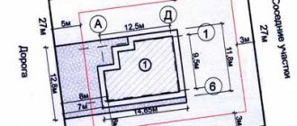
- Based on the results of the data received and all approvals, the cadastral engineer draws up a boundary plan. It includes a textual and graphic part - a verbal description, a detailed diagram of the location of the boundaries of the plots. The plan is drawn up in paper and also electronic form. Then it is certified by the signature and seal of the cadastral engineer;
- Next, the land boundaries are coordinated with the Moscow City Property Department. This procedure is also carried out by companies involved in the division and registration of land;
- The boundary plan is submitted to the state body Rosreestr - thus the land is registered in the cadastral register.