Our Cadastral Engineers will conduct a survey of the boundaries of your land plot and prepare, in accordance with the requirements of current legislation, a Boundary Plan for forming or clarifying the boundaries of the land plot for an apartment building (MCD).
Description of service:
Preparation of a boundary plan for the formation or clarification of the boundaries of a land plot of the territory of an apartment building (MKD) - this is cadastral work necessary for entering information about the actual location of the land plot boundary in the Unified State Register of Real Estate (USRN), a reliable source of information about real estate objects in the territory Russian Federation.
The territory of a multi-apartment residential building (MDB) is a land plot on which the MKD itself and the adjacent territory are located with elements of improvement and landscaping within the framework of the current cadastral registration and the approved project for planning and land surveying of the area. The owners of premises in an apartment building (AMD) currently have the right to initiate the formation of the boundaries of such a land plot and subsequently dispose of it within the framework of current legislation.
Cases when you need the service of a cadastral engineer to prepare a boundary plan to form or clarify the boundaries of a land plot under an apartment building (MCD).
- You cannot find the boundaries of your land plot on the public cadastral map;
- You have received an appropriate recommendation from government authorities on the formation of a land plot for an apartment building (MKD)
- You don't find it in section 3.2. Extracts from the Unified State Register of Real Estate (USRN) of information on the mean square error in determining the coordinates of characteristic points of the boundaries of a land plot;
- You do not find in section 1 of the Extract from the Unified State Register of Real Estate (USRN) information about the error in determining the accuracy (+/-) of the area of a land plot.
Heading
50 Average project implementation period
Heading
50 Number of completed projects
Heading
50 Average project cost
Calculate the cost of the work and receive a commercial offer on our website. Discount if the contract is concluded no later than 10 days from the date of settlement.
Get advice from a cadastral engineer. Describe your situation and we will help solve your problem.
Stages of project implementation by our cadastral engineer
Stage 1
We advise the Customer and prepare a starting package of documents necessary for the preparation of a boundary plan. In some cases, before the start of cadastral work, you may need to prepare or make changes to the planning and land surveying project, which you can also order from our company.
Stage 2
We agree and sign a contract for the implementation of cadastral works based on the results of the general meeting of apartment building residents
Stage 3
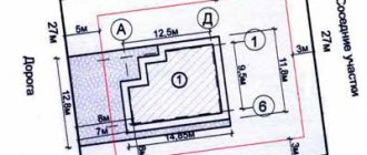
We carry out geodetic measurements of the boundaries of the land plot and process them to obtain the exact coordinates of turning points - boundary signs.
Stage 4
We agree with the Customer on the obtained intermediate measurement results and create a draft boundary plan
Stage 5
We coordinate the passage of the boundaries described in the draft boundary plan with adjacent land users - your neighbors, and draw up a boundary approval act
Stage 6
We submit the boundary plan for consideration to Rosreestr and seek their decision on state cadastral registration
Who formalizes the redistribution of land?
We found out that redistribution of land plots requires a number of documents. Who formalizes the redistribution of land? The procedure for the redistribution of land plots involves the participation of not only land owners, including municipal and state bodies, but other structures and individuals. Thus, as a result of redistribution, a boundary plan is prepared, the right to sign which belongs only to the registered cadastral engineer; in addition, the cadastral engineer provides advice and assistance both at the stage of preparing documents (schemes, projects) and after concluding an agreement.
In order to arrange land surveying, you should select a cadastral company or cadastral engineer in your region from the catalog of cadastral organizations. Following the link you will find a free and convenient online service - a price calculator for cadastral services, with which you can choose a cadastral work contractor.
The survey disk, as well as a package of documents for registration of newly created redistributed land plots, is transferred to the local MFC for subsequent registration with the Rosreestr authorities.
When the newly created plots are registered in the cadastral register, then the old ones will cease to exist.
Thus, due to the redistribution of land plots, it is possible to increase or decrease their area. An increase in area (addition of a land plot) can be either at the expense of state (municipal) lands or at the expense of private property. As a rule, in this situation, monetary compensation is usually specified in the agreement.
Result of work
By contacting our team of cadastral engineers with experience in solving the most difficult situations in the field of cadastral activities, you are guaranteed to get the planned result.
Results of cadastral work on the formation or clarification of the boundaries of a land plot under an apartment building (MKD):
- A copy of the boundary plan approved in accordance with the established procedure in accordance with the norms of the current legislation;
- An electronic file in XML format containing information about the prepared boundary plan;
- Extract from the Unified State Register of Real Estate.
Legislation regulating the provision of services
- Land Code of the Russian Federation.
According to Federal Law No. 267-FZ dated August 2, 2019, changes were made to certain legislative acts of the Russian Federation. One of the provisions of the new law, according to which amendments were made to the Federal Law of December 29, 2004 No. 189-FZ “On the Entry into Force of the Housing Code of the Russian Federation,” the legislator obliged state authorities and municipalities to determine the boundaries of adjacent territories of apartment buildings without waiting until the owners of residential premises make a corresponding request.
Thus, if the land plot on which the apartment building and other real estate objects included in such a building are located was not formed before the entry into force of the Housing Code of the Russian Federation, any owner of the premises in the apartment building has the right to contact government authorities or authorities local government with an application for the formation of a land plot on which an apartment building is located (Part 3 of Article 16 of Law 189-FZ).
Education specified in Part 3 of Art. 16 of Law No. 189-FZ of a land plot is the responsibility of state authorities or local governments.
In order to form such a land plot, authorized state authorities or local self-government bodies take all necessary actions provided for by law, including ensuring approval in the manner established by the legislation on urban planning activities of the territory surveying project, preparing a boundary plan for the land plot, filing an application for state cadastral registration in relation to such a land plot to the rights registration authority.
The formation of the land plot specified in Part 3 of Article 16 of Law 189-FZ is carried out by state authorities or local government bodies also in the absence of an application from the owners of premises in the corresponding apartment building, including during the implementation of complex cadastral work.
The authorized body of state power or the authorized body of local self-government notifies the owners of the premises in the apartment building under which the land plot is formed about the commencement of actions to form a land plot no later than five working days after the relevant decision is made.
Similar services
Boundary plan for the formation of a land plot Formation of a boundary plan for registration of a land plot with cadastral registration or formation of a land plot
More details
Formation and registration of ZOUIT of real estate objects Preparation of documents necessary for entering information about ZOUIT (zones with special conditions for the use of the territory) into the state real estate cadastre.
More details
Removing the boundaries of the plot Removing the boundaries of the land plot
More details
Topographic survey Topographic survey of land plots
More details
Layout of the land plot Preparation of the layout of the land plot. Our cadastral engineers will carry out all necessary work in accordance with the requirements of current legislation.
More details
Cadastral examination Preparation of an expert opinion of a cadastral engineer
More details
Technical report on the location of the object Preparation of a technical report from a cadastral engineer on the location of the object
More details
Correcting a registry error Preparing a boundary plan to correct a registry error
More details
Redistribution of land plots Preparation of a boundary plan for the redistribution of land plots
More details
Division of a land plot Preparation of a boundary plan for the division of a land plot. Work necessary to form two or more plots of land from one original plot.
More details
Consolidation of land plots Preparation of a boundary plan for the consolidation of land plots
More details
Clarification of the boundaries of the plot Preparation of a boundary plan to clarify the boundaries of the land plot
More details
When there is a need for redistribution of land plots
The need for redistribution of land arises for various reasons. Most often, the owner addresses this issue when a problem arises that can be conveniently solved by redistributing land plots. For example, a broken border line; wedging of adjacent areas; communications supply; inconvenient approach or entrance; a house that has already been built goes beyond the maximum permissible boundaries of the fence. After all, in essence, redistribution of the area of land plots is a procedure for combining them and then dividing them. That is, the redistribution was created for the convenience of owners in order to eliminate additional red tape with documents.
The owner of a land plot can, by redistributing land plots, add to the land plot at the expense of adjacent lands and increase its area.
Hold a general meeting of owners
A general meeting of owners will be needed only if not a single owner wants to independently apply to the authorities with an application for the formation of a land plot, and the owners of premises in the apartment building want to do this on behalf of all owners.
In this case, first a general meeting of owners is held, which can be initiated by any owner of the apartment building, and then an authorized person approaches the administration with an application.
The meeting is held in the manner described in Articles 45–48 of the Housing Code of the Russian Federation. The following issues are on the agenda:
- Making a decision on the need to form a land plot for an apartment building.
- Selecting a person authorized to represent the interests of the owners of apartment building premises in state authorities and local governments on the issue of registering the land plot located under the apartment building as common shared ownership.
Determine your benefit
Complete instructions for registering a land plot with illustrative examples were presented on September 27 at the webinar “Registration and maintenance of a land plot” by Elena Shereshovets.
She advised that before starting work, choose the house for which they will be carried out and answer a few questions for yourself.
Determine what legal status the land plot has today. Analyze how beneficial this will be for you. If you have come to the conclusion that registering a land plot is beneficial for you, develop an action algorithm:
- choose who will deal with the problem, determine his powers;
- designate an executive body that will help carry out the work;
- understand when the moment of transfer of ownership comes - from that moment you will have new rights and obligations;
- determine the size of such area;
- analyze possible difficulties and ways to solve them.
The most important thing to do first is to determine the size and boundaries of the land plot in order to clarify its legal status.
The land plot passes into common shared ownership
The land plot under the apartment building passes into the common shared ownership of the owners of the premises after:
- state authorities or local governments will form such a land plot,
- it will be put on the state cadastral register.
There is no need to obtain a special decision from public authorities on the provision of a land plot or state registration of the right of common shared ownership of such a land plot.
Get information on the Public Cadastral Map
The most convenient way to find out the legal status is with the help of the Public Cadastral Map on the Rosreestr website: you will receive an unambiguous report from the government body on whether the land plot under your apartment building has been formed.
To get information, go to the Public Cadastral Map page, select your city and enter your address. Or, if you know the coordinates of the house on a geographic map, indicate them.
Having found the area of interest, click on it. A window will open in which all available data will be collected: exact address, area, cadastral value, form of ownership, legal status of the land plot and others. The status of a site refers to its category and type of permitted use.
This data must be verified by ordering an extract.
In addition to referring to the Public Cadastral Map, there are several other ways to find out the legal status of a land plot:
- request information from local authorities,
- obtain information from the Office of the Federal Service for State Registration, Cadastre and Cartography.
Any owner of apartment buildings, a group of initiative owners, a management organization or TSN can make a request.
If the plot has already been formed and registered with the cadastral register, it passes free of charge into the common shared ownership of the owners of the premises in the apartment building.
How to form a land plot under a blocked building
What to remember
If you want to register a land plot for an apartment building, we advise you to first determine the current status of the land plot and understand how beneficial it is for you.
If you decide to register a plot, follow our instructions:
- Obtain information through the Public Cadastral Map and check it using the extract
- If the land plot has not been formed, write an application for the formation of the land plot to the authorities.
- If none of the owners wants to send a separate application, hold a general meeting of owners.
- If disagreements arise regarding the boundaries of a land plot and the authorities do not want to resolve them, go to court.
You can easily and quickly hold a legally competent general meeting of owners to register a land plot using the “OSS 100%” service. Find out how it works.