“Practice shows that the lack of precisely defined boundaries is the cause of most conflicts between owners of adjacent land plots. But if you carry out land surveying, the exact boundaries of your site are entered into the Unified State Register of Real Estate. In this way, you will protect your rights and minimize the occurrence of land disputes,” Rosreestr explained.
The presence of clearly established boundaries allows you to carry out any operations and transactions with the site without unnecessary problems. In addition, land surveying will help correct possible errors, including in information about the actual area used.
“Incorrect information about the area of a plot may cause an incorrect determination of its cadastral value and, as a consequence, an incorrect determination of the amount of land tax,” the department added.
How to find out whether the boundaries of a land plot are included in the Unified State Register of Real Estate?
All necessary information is contained in the extract from the Unified State Register. If the register does not contain the necessary information, the extract will contain a special statement.
You can obtain an extract using electronic services on the Rosreestr website, as well as on the website of the subordinate Federal State Budgetary Institution FKP Rosreestr.
You can also use the “Public Cadastral Map” (PCC) service. The easiest way to find a specific object on it is by address. If in the object description window there is o or the area is indicated as declared, it means that the boundaries of the site have not been established.
Determination of parameters and area offline
Having the cadastral number of a plot of land or any other property, it is possible to determine:
- his address (coordinates),
- borders,
- square,
- other legal information.
All information is recorded by Rosreestr during the registration of the object. For this purpose, a nationwide database of cadastral numbers has been created.
All information on the cadastral number can be obtained in paper form in the form of a cadastral passport by an individual or legal entity directly from the Rosreestr division, the multifunctional center (MFC) . To do this, you must make an official request at these institutions or through the post office.
also
need to provide the following documents :
- check for payment of state duty;
- Russian passport;
- a document that certifies the applicant’s ownership of the land plot.
After submitting the entire package of documentation, the citizen receives a receipt, which will need to be presented to receive a cadastral passport.
The state duty for individuals is 200 rubles, for legal entities – 600 rubles.
How to clarify the boundaries of the site?
Land surveying is carried out by cadastral engineers. They are the ones who carry out all the necessary measurements and calculations. By law, every cadastral engineer is required to be a member of a specialized self-regulatory organization (SRO). SROs monitor the activities of their members and consider complaints from applicants if cadastral work was carried out with violations.
You can obtain information about a specific cadastral engineer on the Rosreestr website in the “State Register of Cadastral Engineers” section. It contains information about his special education, qualification certificate, and confirmation of his membership in the SRO. In addition, using the electronic register of cadastral engineers, you can find out about the results of a specialist’s professional activities.
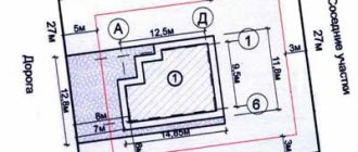
A cadastral engineer visits the site and takes the necessary measurements. If there is a fence, then measurements are taken along it. If there is no fence, it is better to mark the corners of the area with pegs in advance. After reviewing the measurement results, the boundaries of the site must be agreed upon with the owners of adjacent plots.
After this work, the cadastral engineer draws up a boundary plan.
Is it possible to find out the size and area of a land plot by cadastral number? How to do it
Knowing the size of the boundaries and area of your land can be useful if disputes arise with neighbors over the division of nearby territories. To resolve the conflict peacefully, it is enough to obtain official information about the characteristics of the site. You can obtain data on the area of a land plot and its exact dimensions in meters without leaving your home. There are several ways to do this.
A plan of the land plot will open in the next browser window. By clicking on the “KK Plan” link, a plan of the cadastral quarter on which the land plot is located will open.
- The exact address;
- Land area;
- Cadastral value;
- Date of cadastral registration;
- Category and type of permitted use;
- Plan and dimensions of the land plot.
What documents are needed?
Clarification of the boundaries of a land plot is carried out on the basis of information contained in the title document for the land plot. Additionally, information specified in the documents that determined the location of the boundaries of the site when it was formed can be used.
If there are none, the clarification can be carried out in accordance with the boundaries that have existed on the ground for 15 years or more and are fixed using natural objects or objects of artificial origin, which make it possible to determine the location of the boundaries of the site. This may require:
— situational plans contained in technical passports of real estate objects (located on a land plot), which are prepared by the bodies of state technical accounting and technical inventory (BTI);
— forest management materials;
— planning and cartographic materials available in regional authorities of architecture, construction and housing, local authorities;
— documents on territorial planning of municipalities;
— projects for the organization and development of the territory of dacha, garden and vegetable garden non-profit partnerships.
How is the cadastral number of an apartment deciphered?
It has more information, in addition to the designation of the land plot on which the capital building is built, the cadastral number of the building and the inventory number of the apartment are indicated. When one apartment is divided into two or more parts, each unit is assigned its own number.
Registration of new objects is done by application - you must ask for the termination of ownership of the pre-existing object and registration of the newly formed ones. The application is accompanied by a receipt for payment of the fee and identification documents of the applicants.
According to the provisions of the Civil Code of the Russian Federation, apartments, along with houses, also belong to independent real estate objects and have their own individual number. It is assigned upon commissioning of the facility and registration with the relevant government agencies. When issuing a technical passport for an apartment, the code is indicated on the title page. What does it mean? Let's take the example 63:18:17:0035:2:1.
63 – number of the cadastral district, 63rd assigned to the Samara region; 18 – number of the cadastral district, 18th assigned to the Kinelsky district; 17 – cadastral quarter number, 17th assigned to the city of Kinel; 0035 – number of the land plot on which the building is located; 2 – number of the building or other permanent structure; 1 – apartment or separate room number.
Not only its owner, but also anyone can obtain a cadastral number for an object. Publicity of data increases the security of transactions and other legal actions. The number is assigned only once; even after the object is deregistered, it is stored in the archive. This is necessary so that problems do not arise in the future when solving various issues.
How to use the real estate cadastral number
Having a cadastral number, you can find out:
• whether the land plot or other real estate object with such a number matches the actual address; • whether there are any deviations in the size and configuration of the site or permanent structure; • who is the owner of the object (personal or state property); • how the object (land or building) can be used; • cadastral value and time of its determination; • are there any restrictions.
Using the number allows you to minimize the risks of fraud when selling/purchasing various types of real estate. The numbers are assigned to facilitate state control of the turnover of land and property of capital buildings when calculating taxes.
What to do if you lose your property rights
If, when checking the cadastral number, a change in rights to real estate was discovered due to independent reasons, then you can claim compensation for the loss of ownership rights from the budgetary funds of the Russian Federation. The money is given as a one-time payment, the amount depends on the cadastral value of the property, payments are made only by court decision. But before filing a claim, you need to know the following facts:
• the amount of compensation cannot exceed one million rubles; • the state has the right to recourse.
As judicial practice shows, it is very difficult to win lawsuits against the state; such cases are rare. But it is very easy to lose under recourse claims.
How to coordinate the boundaries of the site with the neighbors?
The cadastral engineer will also help in coordinating new boundaries with the owners of adjacent plots: he must send them notifications by postal or e-mail; individual approval is also allowed.
If they cannot be found, the cadastral engineer publishes a notice in the local press. The addressee will be considered notified even if he does not read this announcement.
Rights holders of adjacent plots must confirm their consent by signing an agreement document. If they do not agree, they can forward their objections to the cadastral engineer. Objections must be recorded in the act of approving the location of the boundaries of the land plot, and also attached to the boundary plan.
Next, the documents must be submitted to Rosreestr. If there are justified objections, registration and registration activities will be suspended, and neighbors will have to resolve disagreements in court.
Method number 1 - use the RosReestr card
To find out the plan of a land plot by cadastral number, click on the link “Land plan” in the pop-up window: How to find out the size of a land plot by cadastral number
Method number 2 - download the SASPLANET program
The most convenient and advanced way to find a land plot by cadastral number on a map online is using a smartphone. To do this, download and install the free mobile application “KadastrRU” from the AppStore or GooglePlay.
To find out the boundaries of a land plot by cadastral number, you need to order and receive a cadastral passport of the land plot. It will indicate the exact coordinates of the corners of the memory. Using the coordinates of the corners, they carry out a geodetic survey of the area and determine the boundaries of the land plot. The cost of removing one corner ranges from 500 to 1000 rubles.
What other data can you get?
By the cadastral number of the land, it is possible to find out not only its area and dimensions, but also other data:
- information about the owner of the property, including his TIN;
- number of owners indicating the share of each;
- name of documents confirming ownership;
- Address of the object;
- date of registration in the Unified State Register of Real Estate;
- number of storeys;
- boundaries and coordinates;
- functional affiliation, purpose;
- presence of encumbrances and arrests;
- site status;
- land plot plan and situational plot plan;
- cadastral value (you can find out what it is here);
- list of transactions involving this plot.
Knowing the cadastral number of the land, you can get access to its main characteristics, including size and area. Such information is taken from the unified Rosreestr database and is official. It is offered to receive it both in paper and electronic form through online services located on government and commercial portals.
Risks of acquiring land
When concluding a transaction, the buyer risks more than the seller. In case of illegal actions, it is easier to return land than money. There are few pure transactions on the market; among the main risks of acquiring a land plot are:
- No details. The seller is interested in quickly concluding a deal, taking into account his own interests, and not the interests of the buyer. During an accelerated sale, the details are omitted and the seller provides those details that facilitate the rapid sale of the land asset.
- Incomplete information. The presented documentation may not contain all the data, which will affect the timing of the acquisition of the asset.
- Availability of communications. Inspecting the property is the first thing a buyer should do. So he can personally make sure that there are no utility lines on the site (if there are any, it is difficult or impossible to move them).
- Lack of communications. Regardless of the goals assigned to the land asset, it is impossible to do without utilities. Make sure they can be routed before purchasing.
- Inattention. Do not rush during the inspection, it can be expensive.
The land asset may have a different purpose; the land is not suitable for the construction of the required facility. Risks lead to insufficient legal purity; the transaction may be canceled or declared illegal.
Land Share How to Find Out Where It Is
The law provides for cases when forced withdrawal of a land plot from agricultural land is possible:
- if within three years from the moment the owner acquires ownership of the plot, it is not used for farming. Exception: the period does not include the period of time when it was not possible to use the site due to a natural disaster. A period of 2 years is provided for the cultivation and development of the site.
- if the level of soil fertility has decreased significantly. A decrease in fertility is determined by several criteria: a decrease in the amount of organic matter by 15%, mobile phosphorus, exchangeable potassium, levels of acidity, alkalinity, etc.
- with ineffective and improper use. The authorized bodies of land control authorities identify these facts and issue administrative penalties with orders to eliminate violations. If the violations are not eliminated within the prescribed period, then the materials are transferred to the executive authority, which has the right to go to court and demand the seizure of the plot and sell it at public auction
Also, seizure of a land share is possible by the bailiff service if the owner is a debtor in enforcement proceedings.
If there are no documents for a land share, you can order an extract from Rosreestr addressed to the owner of the share. If such information is registered in the register, then you can get a duplicate of the ownership of the land share here. If such data is not available, then information about the issued certificate can be found: in the state farm, the archives of the village administration, the land department of the local government.
If you cannot find the necessary documents using these methods, you can go to court to restore them.
Ekaterinburg, lane. Separate, 5
Gagarin transport stop
Tram: A, 8, 13, 15, 23
Bus: 61, 25, 18, 14, 15
Trolleybus: 20, 6, 7, 19
Minibus taxi: 70, 77, 04, 67
- The owner of the land plot is unknown.
- The owner of the plot died and had no heirs.
- After the death of the owner of the share, the heirs do not have the opportunity to use it.
- The legal heirs refused to enter into the inheritance or were excluded from it.
Dispute in the city court of Gatchina, Leningrad region. Its essence boils down to the fact that the plaintiff files a claim for recognition of rights to a share, and the defendant in the case is the joint-stock company. In this situation, the original property document was lost. According to the judges, when collective farms are reorganized, land shares automatically transfer to the authorized capital of the new company. With the help of lawyers, we managed to restore ownership of the land share. The decision was justified by the fact that the legislation in force for the period of 1992 did not provide for the reorganization of collective farms by transferring land to new joint-stock companies without allocating shares to former employees. Contribution of a share to the authorized capital of a joint-stock company can only be made upon a written application from the owner. There is not a single legal norm that speaks about the automatic transfer of plots. In this situation, the plaintiff did not sign any statements and was not invited to the constituent meeting. The dispute was resolved in favor of the plaintiff.