“Practice shows that the lack of precisely defined boundaries is the cause of most conflicts between owners of adjacent land plots. But if you carry out land surveying, the exact boundaries of your site are entered into the Unified State Register of Real Estate. In this way, you will protect your rights and minimize the occurrence of land disputes,” Rosreestr explained.
The presence of clearly established boundaries allows you to carry out any operations and transactions with the site without unnecessary problems. In addition, land surveying will help correct possible errors, including in information about the actual area used.
“Incorrect information about the area of a plot may cause an incorrect determination of its cadastral value and, as a consequence, an incorrect determination of the amount of land tax,” the department added.
Why do this?
Land transactions
When making civil transactions involving the transfer of ownership of land, the boundaries of the site must be clearly defined. The fact is that any legal transactions are carried out with land, which has clear boundaries. The only way to determine these boundaries today is land surveying.
Defining boundaries
Sometimes, during the use of a land plot, the owner needs to determine or restore boundaries. If the land was purchased or received ownership a long time ago or the documents have not been preserved, a boundary plan must be drawn up. Sometimes establishing boundaries is required if mistakes were made in the past during land surveying.
Allocation of land from collective ownership
If the land is collectively owned, then in order to allocate a land plot to an individual member it is necessary to establish the actual boundaries of the plot. The obligation on this issue falls on the shoulders of the future owner.
Redistribution
The process of dividing one plot into several owners or, conversely, if several plots are transferred to the possession of one owner, requires the preparation of a new boundary plan. In this case, new land plots are formed, the boundaries of which should be established. In order to obtain a cadastral passport in this case, it is necessary to carry out land surveying and obtain a land survey plan.
Registration of ownership
When registering ownership of a land plot, it is necessary to establish clear boundaries of this land plot. Any registration of property rights and ownership of the plot is carried out only if there is a boundary plan.
Increase in area
According to the Land Code of the Russian Federation, each land owner can add to it a part of the land that is not anyone's property. Such a procedure can be carried out in any legal way with subsequent addition of data to Rosreestr. To establish the exact boundaries of the new site, you will need to draw up a boundary plan.
Dispute Resolution
Resolution of disputes between neighbors is carried out exclusively by contacting the body for registration and accounting of land plots (Rosreestr). But Rosreestr usually does not deal with these problems on its own; it sends the owners to the court, which initiates the procedure for land surveying to make a decision.
Construction of a permanent structure
In order to build a house or other building on a plot, the owner must comply with the requirements of laws and regulations, for example, adhere to certain parameters (spacings, setbacks, etc.). The determination of any parameters and dimensions of the structure is compared with the exact boundaries of the site, and therefore is carried out in accordance with the boundary plan.
Notification of neighboring property owners
Once the approximate day for the survey has been set, it is required to notify all owners of land plots bordering the given one .
The law sets a time limit for notification: it must be sent no later than 30 days before the expected day of approval.
You can notify your neighbors in several alternative ways:
- Notify by registered letters with notifications . The places of residence of neighbors can be found out in the cadastral service. It is advisable to use this type of notification when there is confidence that the citizen will not sign the notice, and therefore the act of approval. Therefore, it is advisable to send three letters to the neighbor, since a letter sent three times in the name of one person becomes a basis for believing that the signature of this person received.
- Personally deliver the notices to each of the recipients, receiving his signature. If there is no signature, it will be impossible to prove that the neighbor was not served with a notice.
- Send an email (with a read receipt). This type of notification is the least popular, since not everyone has an email and email addresses are not publicly available.
- Publish an ad in the local press . This is usually practiced if the place of residence of a neighbor cannot be determined, or when delineating plots located within a gardening and dacha partnership.
A notice sent to a neighbor can be written in free form (a sample can be viewed and downloaded via the link), but it must include the following information :
- The notification begins with an address to this specific citizen indicating his full name.
- Next, enter the full name of the person requesting the procedure, his address and telephone number for contacts.
- The data of the cadastral engineer, his full name, address, telephone number are recorded.
- The address of the actual location of the site and its cadastral data are indicated. If there is no address yet, the block where the site is located is indicated.
Information about adjacent areas is included, with addresses and exact numbers. At the end, the time and place of the planned coordination and ways to obtain information about the procedure being carried out are indicated.
What the law says
Due to changes in the new Federal Law of the Russian Federation No. 447, which regulates cadastral activities, it is now impossible to sell or donate land without a boundary plan. Since until 2008 this was not a mandatory condition, many owners do not have such a document.
Now, before selling a plot or transferring it by inheritance, the owner must spend money on drawing up a boundary plan and wait from 10 days to 2 months until the plan is ready.
Feasibility of the procedure
Since the procedure for land surveying is inextricably linked with the process of land management in Russia, you will have to contact the local departments responsible for it in the locality. Their department is responsible for regulating territorial boundaries, which is important when taking into account urban development plans, even if the land is located outside of large populated areas.
Dear readers!
Our articles talk about typical ways to resolve legal issues, but each case is unique. If you want to find out how to solve your specific problem, please contact the online consultant form on the right →
It's fast and free!
Or call us by phone (24/7):
If you want to find out how to solve your particular problem, call us by phone. It's fast and free!
+7 Moscow,
Moscow region
+7 Saint Petersburg,
Leningrad region
+7 Regions
(the call is free for all regions of Russia)
The procedure takes a lot of time even for trained citizens. Often you have to wait six months for its completion. In addition, you will need to prepare some documents, which also takes time, especially if the site has not been properly managed for a long time. A lot of time will be spent visiting government institutions. When it comes to conflicts with neighbors that have escalated into legal proceedings, you won’t be able to breathe a sigh of relief any time soon.
Very often, land surveying issues involve unauthorized occupation, clarification of boundaries for tax recalculation and when planning the development of a site. It is also important to know that in case of neighbor disputes, the one who carried out and completed the entire land surveying process earlier will be in the right. In this regard, even if there are no conflicts now, it still makes sense to start defining clear boundaries.
Required documents
To order land surveying, you need to collect the following documents:
- Passport of the land owner or a power of attorney certified by a notary, if the owner’s representative is handling the paperwork.
- Documents for land that confirm who the owner is. This may be a gift agreement, a certificate of inheritance, or a purchase and sale agreement.
- Certificate of ownership of land or an extract from the Unified State Register of Real Estate.
- Cadastral passport or cadastral extract.
- If there are buildings on the site, then they must have a passport .
What affects operating time
So, let's consider in detail the factors influencing the time of establishing the boundary on the site. These include:
- Open access to the site (if access to the land is limited, the process may take a long time).
- Availability of the necessary information (cadastral data about the object in the USRN authorities).
- Opinion of the owner of adjacent plots (presence of controversial issues).
- Involvement of special equipment to perform the work (it is necessary to find out whether special technical means are required in order to allocate an area).
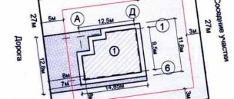
Samples of land surveying documents
The boundary plan contains all the information about the land plot, including the owner’s data and the designated boundaries of the plot, and its basis is an extract from the Unified State Register of Real Estate. The document also contains information that the engineer considered necessary to enter after inspecting the plot. Information that is taken into account in the boundary plan:
- A graphic representation of the land plot, including turning points through which land surveying occurs;
- Information about the characteristics of the land plot and information that is different from other plots;
- If boundaries and plans have undergone changes, then it is indicated what and when;
- Conclusion of a cadastral engineer with references to the law (if required);
- The act of approval of boundaries is signed by neighbors on the site, if any.
The boundary plan includes text and graphic parts. The text part includes all information about the land plot, including the act on the approval of boundaries. The cadastral engineer enters the following data into it:
- Initial information about the site;
- What calculations and measurements were carried out;
- What changes were made to the land surveying in the past;
- Information about neighboring plots;
- Conclusion of a cadastral engineer.
- An act of approval of the boundaries of the site, signed by the neighbors.
In the graphic part of the plan there is a drawing depicting all the roads passing between the site. The following information is posted here:
- diagram of the object and neighboring areas while maintaining scaling;
- drawing of the site highlighting its components (if any);
- outlines of turning (nodal) points through which the boundary lines of the site pass.
The plan is issued on disk and on paper in 2 copies, one to the cadastral engineer, the second to the owner of the site. You can also obtain a cadastral plan in electronic form, but you should notify the cadastral engineer about this in advance.
When is it possible to set boundaries without agreement?
If the boundaries of the site do not pass through the sites included in the Unified State Register of Real Estate, they are not required to be approved by law.
It is necessary to coordinate only those areas that simultaneously serve as boundaries between neighboring areas (Article 39 of Federal Law No. 221 “On Cadastral Activities” as amended on July 3, 2016). That is, if the site borders on vacant land or faces the street, there is no need for approval.
No approvals are required if this land plot is adjacent to :
- forest area;
- a specially protected area (for example, the borders of a country);
- agricultural lands in the Far North, Far East and Siberia;
How to carry out land surveying
If the owner of the site decides to carry out land surveying, then he must find a cadastral engineer and contact him. You can choose a specialist based on the advice of relatives or by searching on the Internet. But before you enter into an agreement with him, you should check whether he can be trusted.
The cadastral engineer must:
- be a member of an SRO (self-regulatory organization);
- have a personal seal for “paperwork”;
- have an electronic signature certificate for “electronic files”.
You can check the information on the official website of the SRO or in the state register of cadastral engineers on the Rosreestr website. To do this, you only need to enter the last name, first name and patronymic of the cadastral engineer. If next to the specialist there is an entry “included in the register,” then you can contact him to draw up a boundary plan. By the way, in the specialist’s card you can find additional data: how many years he has been working, whether there were any errors or failures in his activities.
Be careful! If a cadastral engineer is not included in the SRO register, then he cannot perform cadastral work (including land surveying). Documents prepared by such a specialist will not have legal force.
The cost of drawing up a boundary plan for different cadastral engineers can be different; it varies from 2 to 10 thousand rubles. The boundary plan is drawn up within 10 days, but there are delays of up to 2 months. The efficiency of drawing up a document depends on how quickly and correctly all the documents are collected by the owner of the site.
How to divide a plot of land into two
The division of land consists of a set of geodetic and cadastral activities, through which two or more are formed from one plot.
Divide the land property if the following circumstances exist:
- Land holdings with a large area must be divided to sell plots that exceed the size required by the owner;
- The land satisfies certain wishes, but it must be divided when the spouses divorce;
- Some part of the property is rented from the owner;
- The plot is divided to use its components for various purposes. This means that a certain proportion of the site involves a change in purpose;
- Several co-owners decided to divide the joint plot and register the allocated property by each individual, for the further use of their share.
The plot can be divided only at the own request of the sole or all existing landowners. The division of land occurs in several steps.
If this procedure is necessary, follow these steps sequentially:
- sign an agreement with an organization licensed to carry out land surveying work (establishing property boundaries);
- obtain written approval, drawn up in the form of consent, from the remaining co-owners to carry out boundary work;
- if it is not possible to reach an agreement peacefully with the co-owners, then contact the judicial authorities and obtain the appropriate resolution;
- present the cadastral work specialist with the supporting documents confirming the rights to the land plot;
- await the results of determining the boundaries of land ownership by the cadastral engineer. Boundaries must be established with the participation of co-owners or their authorized representatives authorized to take such actions. Next, the specialist sets the boundaries of the dividing object and the newly formed plots. The boundaries are marked with special signs. In addition, the engineer establishes information about the area of the original object and two new ones. As a result, they schematically display the boundaries of the land and formulate land survey documents (acts defining boundaries, drawings, statements of calculating the scale of property);
- Address the application to the architecture and urban planning authorities to assign addresses to the established landholdings, and attach to it the appropriate documentation (files formed as a result of land surveying, title papers, cadastral passport of the original site, approval of the owners or a judicial act);
- register the newly formed plots with cadastral registration. To do this, contact Rosreestr, having with you a written application, passport, land survey file and address decree.
Send your application by mail, present it in person, or use the government services portal. After receiving the papers, the bodies authorized to carry out state registration will carry out the procedure for registering objects. At the end of the process, you will receive cadastral passports for the formed plots.
After completing the above division steps, register the rights to the new property along with the remaining owners.
How is land surveying carried out?
After collecting all the documents and concluding a contract for the work, the owner of the site must pay for the services of a specialist and discuss with him the date of the site visit. On the appointed day, a surveyor or cadastral engineer arrives at the site with special GPS equipment and measures the boundaries of the site, determining their actual coordinates. After receiving the boundary plan, a copy of it is sent to Rosreestr.
When establishing the boundaries of a plot, the data obtained is agreed upon with the owners of neighboring plots if:
- the area under study has common boundaries with them;
- the neighboring plot is not visible on the cadastral map;
- the owner of the neighboring plot has a document of ownership of this plot.
In the event that land surveying is needed to combine several plots or to divide one plot, there is no need to compare the boundaries and coordinate this with neighbors.
Clarification of boundaries without the consent of neighbors
Many people are interested in the question: is it necessary to have the consent of neighbors when carrying out land surveying of their property? The law provides for cases when it is possible to carry out approvals without involving neighbors.
Such cases include:
- All adjacent landowners have already carried out land surveying of their plots , the boundaries have been documented and in fact, the interests of the customer of these cadastral works have not been affected. The cadastral engineer must obtain all the data on these plots and note this in his documents. The plot is simply “tied” to the already registered boundaries of adjacent plots.
- It is impossible to establish the exact place of residence of the neighbor , the site has long been abandoned, no one is looking after it, his address and contact details are unknown to anyone. In such cases, advertisements are published in newspapers. If the owner of the site does not make himself known within a month, the approval is considered to be carried out by default.
- The owner does not appear at the appointed time , despite the fact that he was notified by letter or in person. There were no written objections or justifications for his reluctance to participate. Therefore, the approval is considered as received, the corresponding entry is entered into the act, and the boundary plan is supplemented with the necessary documents.
Please keep in mind for the future that if this neighbor provides evidence that his failure to appear is valid (illness, missed notice, stay abroad), he has the right to seek a review of the approved boundaries through the court.
When a written refusal indicating the grounds for absence is received within a month after notification , this document is also filed with the approval act, and a special note about this is made in the text.
Objections do not prevent full use of the site , but future disputes are possible, and the buyer will need to be notified of this upon sale.
The difference between land surveying and cadastral work, geodesy and privatization
Land surveying is often confused with other procedures in the field of land management. Let's look at each of them.
Cadastral work is a type of work on the preparation and preparation of any documents on real estate. This includes drawing up a technical and boundary plan.
Geodesy is responsible for measuring, designing and processing data in the form of drawings; it is necessary to draw up a plan for the placement of objects on the site. A surveyor can determine and establish the boundaries of a site on a par with a cadastral engineer, as well as perform calculations of excavation work on a site, determine the vertical and horizontal lines for a construction site, and outline construction sites and placement of communications.
Land privatization is the transfer of state property into personal property. The owner of the plot receives documents for the right to own the land and the opportunity to dispose of it at his own discretion: sell, donate, inherit.
Is it possible to challenge the land survey of your own or a neighboring plot?
Of course you can, if there is a legal basis. You just have to follow a certain sequence of actions:
- First of all, file a complaint with your local administration.
- If the administration is inactive, get a written refusal from the officials to satisfy your material rights and contact the Prosecutor’s Office
- If the Prosecutor’s Office also receives a refusal to file a complaint, file a statement of claim with the court.
Trial proceedings require careful preparation. We recommend using the assistance of experienced land law lawyers.
Initial free consultations are available on the prav.io website. possible at any time of the day.
A lawyer found on the site can also help in preparing the necessary documents (including the claim itself). And if he lives in the same city with you, he can undertake representation in court and full protection of your rights.
FAQ
Is it true that a law has been passed according to which land surveying of a summer cottage can be carried out free of charge?
According to No. 221-FZ chapter 4.1. money has been allocated to carry out comprehensive cadastral work. That is, land surveying and drawing up boundary plans are carried out not for one site, but for an entire cadastral quarter. A plan for carrying out complex work is drawn up by local authorities. You can find out in which settlements and in which areas complex work will take place from the media or on the portals of local governments. Owners of plots that belong to a certain cadastral block must only provide access to the territory of the plot, and money to pay for land surveying will be allocated from the budget.
What to do if a neighbor does not give his consent to determine the boundaries of the property?
You should double-check the documents and try to resolve disagreements peacefully. If you can’t reach an agreement, then write a complaint to the prosecutor’s office and then to the court. Then the boundaries will be determined in court and a boundary plan drawn up.
Is it possible to carry out land surveying for free under the dacha amnesty?
The dacha amnesty allows you to quickly and free of charge register the land and buildings on it as your property. But the dacha amnesty does not include the land surveying procedure, which must be ordered separately.
Is land surveying a mandatory procedure for land owners?
This legislation does not require owners to carry out mandatory land surveying. But if you intend to sell the house or pass it on by inheritance, then by law this cannot be done without a boundary plan. Also, timely land surveying will allow you to avoid conflicts with neighbors over illegally seized lands.
Features of drawing up an act
Today there is no generally applicable, standard form for the act of agreeing on the boundaries of a land plot, so it can be written in any form. The only thing that needs to be taken into account is that the sequence of its content meets certain standards for compiling this kind of documentation. This means that the form should be divided into three parts:
- beginning is the name and number of the document;
- main section - information about the site, the boundaries of which are being agreed upon;
- conclusion - the decision made (whether they were agreed upon or not) and the signatures of the parties.
The act can be written manually or typed on a computer. For a printed document, an ordinary blank sheet of paper of any convenient format is suitable (A4 is mainly used).
The document must be made in a number of copies equal to the participants in the approval procedure - one for each interested party.
Conclusion
- You cannot carry out land surveying and determine the boundaries of the site yourself; for this you need to have a license for geodetic and cartographic activities.
- Land surveying is not a mandatory procedure for land owners. But if transactions involving the transfer of land ownership are planned, the boundaries of the site must be clearly defined, which means that a boundary plan will be required.
- When choosing a cadastral engineer to draw up a boundary plan, check whether he is a member of an SRO. If a specialist is not a member of a self-regulatory organization, then the documents that he draws up will be considered invalid.
What is the statute of limitations for land surveying?
The limitation period for land disputes is a rather ambiguous parameter. As for the limitation period for land surveying, in accordance with civil law it is three years , but the moment this period is calculated is the moment it becomes clear that rights have been violated. When this moment comes depends on your arguments. Therefore, all cases are individual. It all depends on the reasons for going to court. If interference and obstacles are created for you in the use of land, then the statute of limitations does not apply to such appeals (Article 208 of the Civil Code of the Russian Federation).
What devices are used
Depending on the purpose and principles of operation, all devices used by a cadastral engineer when carrying out boundary work can be divided into 2 main groups :
- GPS technology;
- optical and laser devices.
GPS devices are essentially satellite signal receivers .
Their most important advantage is versatility.
One such device can replace several simpler measuring instruments at once.
In particular, with the help of this equipment you can :
- determine the coordinates of any point on the ground with maximum accuracy;
- measure distances;
- draw up a detailed map of the site.
These devices are suitable for use in any climatic conditions, visibility does not matter . Processing of data obtained with their help can be carried out automatically. In addition, they are very easy to operate.
Optical and laser devices make it possible to determine distances, angles, and height levels. Modern optical and laser devices are also highly accurate and can be used in all weather conditions.
Their measuring distance, although not unlimited, is still quite large; for practical purposes, the capabilities of these devices are more than enough .
Let us consider in more detail the optical and laser devices most often used in the process of performing boundary work.
| Types of devices | Features of application |
| Levels (optical) | They are used to determine distances and angles. To measure the distance, you will need an additional device - a leveling rod. Designed to perform measuring work at a horizontal level. |
| Theodolites (optical) | They have similar purposes to the level, but do not require any additional devices. Often used to determine the elevation values of points on the vertical plane. Can be used both horizontally and vertically. |
| Total stations (electronic) | These devices combine the functions of a theodolite, rangefinder and computer. They allow not only to carry out measuring work, but also to digitally save the information obtained. This is possible due to the fact that special applications are installed in the memory of electronic total stations. The devices have a design that allows them to be reliably protected from the effects of adverse environmental conditions (from water or dust entering the housing). |
| Laser levels and tape measures | Convenient to use when measuring relatively short distances. To obtain correct results, it is necessary to control the position of the measuring tape to avoid sagging. |
Levels and theodolites are not only optical, but also laser. The latter are more often used not in geodetic work, but in construction work.
must be mounted on a tripod during measurements .