Citizens wishing to acquire land ownership have to face the problem of finding free land plots that suit them according to all criteria.
Public cadastral maps, as well as Google and Yandex maps, are designed to greatly facilitate the task of searching and selecting the desired site for the population.
All you need for this is a computer (tablet, smartphone, laptop) and Internet access.
However, first things first.
What is the PKK
The public cadastral map (PCC) is an online service that shows on a virtual interactive map all real estate objects registered in the Unified State Register of Real Estate .
Also, all information regarding the areas indicated on it is indicated there. Some of this information is publicly available and with its help you can easily find the plot of land you need.
More details about PKK are written in a separate article on our website. This is what the public cadastral map looks like on the official website of Rosreestr.
You can find it not only on this site - there are many similar maps on the Internet.
Types of zones
In the process of urban planning zoning of a territory, specialists can distinguish the following territorial zones:
- residential;
- public and business;
- production;
- engineering and transport infrastructure zones;
- agricultural use;
- recreational purposes;
- zones of specially protected areas;
- special purpose;
- placement of military facilities;
- In municipalities, other types of territorial zones may be allocated, based on the specifics of the area.
Above is a general classification of territorial zones. In turn, within each of them subspecies can be distinguished. Thus, residential zones may include development zones:
- individual residential buildings;
- low-rise buildings;
- mid-rise;
- multi-story.
Also, in residential areas it is allowed not only to build houses for living, but also social, communal and household facilities, healthcare (hospitals and clinics), education (schools, kindergartens, etc.), religious buildings (churches), parking lots, garages . At the same time, it is not allowed to build industrial buildings and structures that negatively affect the environment.
The Town Planning Code of the Russian Federation specifies the main, conditionally permitted and auxiliary types of permitted use of sites and capital facilities. Accessory uses usually complement the primary and conditionally permitted uses of the sites.
The table shows the intended purpose of various land plots, taking into account their territorial zone.
| Name of the territorial zone | Code | Intended use |
| Residential | AND | for development of residential buildings, placement of infrastructure facilities, SNT and DNT territories |
| Public and business zones | D | for the placement of retail facilities, administrative buildings, educational and healthcare facilities, etc. |
| Production | P | for the placement of industrial, municipal and warehouse facilities |
| Engineering and transport infrastructure zones | I, T | for placement of railway, road, air, river, sea and pipeline communications |
| Recreational areas | R | for organizing recreation for the population - forest areas, gardens, parks, forest parks, beaches, health and sports facilities, etc. |
| Agricultural use zones | WITH | for placement of arable land, vineyards, orchards, vegetable gardens, hayfields and pastures, nurseries, greenhouses and other facilities for growing agricultural crops and livestock |
| Special purpose zones | TO | areas for cemeteries, landfills, crematoria, memorial parks |
| Zones of military facilities, other zones of restricted areas | short circuit | zones for the placement of military and other sensitive facilities: training grounds, etc. |
Advantages of self-selection
Using a public cadastral map is not the only possible way to find a vacant plot.
However, this method has a number of advantages, such as :
- Opportunity to independently study the terrain. You can also find out if there is a body of water, forest or other geographical features nearby;
- Find out the exact address of the desired land plot;
- Study and select suitable infrastructure near the vacant site;
- Study information about neighboring areas that are already occupied;
- The opportunity to choose land in any region of Russia without making any long trips.
We determine the category of land and the type of permitted use based on our goals
Please note that it is very important to clearly formulate for yourself the purpose of acquiring land! This must be done before starting the search. After all, the category of land from which it will be formed, the type of its permitted use, and the procedure for its formation and registration will depend on the purposes for which you are purchasing a plot.
If you are planning to build a residential building, choose a site:
- for individual housing construction (IHC) from the lands of settlements;
- for running personal subsidiary plots (LPH) within the boundaries of populated areas;
- for gardening (dacha farming) from lands of settlements or agricultural purposes.
According to the law, it is not allowed to build a house on a garden plot of land.
Having decided on the purpose, proceed directly to the search for the site.
Step-by-step instruction
We will analyze in detail what actions should be taken to find an unoccupied plot of land.
Territory designation
To begin with, you should decide on the search territory, that is, select the region you need . Initially, you will see a complete map of the Russian Federation, divided into large territorial zones, which are almost identical to the borders of the constituent entities of the Federation.
Having selected the region you need, move the cursor there and scroll (mouse wheel) to zoom in or out. Or, in the lower right corner of the map, click on “+” or “-”.
Map exploration
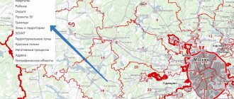
In the menu on the left, select the “Manage Card” button. Then go to the "Thematic Maps" section.
Tick o.
It is better to use the specified values when you have already defined the search territory on the map and enlarged it so that settlements and areas on them become visible.
Then, by checking the box, all occupied areas will turn pink, and free areas will remain white .
This can be clearly seen in the screenshot.
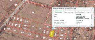
By clicking on the area you are interested in, you will see all the publicly available information about it.
As you can see in the photo, nothing is indicated in the “Form of ownership” column . This means that the site is potentially vacant, but this is not certain.
Land status information
In the information window of the public cadastral map, which contains information about the land plot, there is a “Status” item.
When searching and selecting a free plot, you should also pay attention to this point.
Types of cadastral statuses:
- Registered – a land plot that has passed the official state registration procedure;
- Previously registered - land plot that was registered before March 1, 2008, when land legislation was changed;
- Temporary - this status is given to areas whose information was relatively recently entered into the Rosreestr, but all the necessary registration procedures have not been completed and are still ongoing;
- Canceled - this status is assigned to lands that were previously in temporary status. If within 5 years the plot has not been officially registered, then its status is canceled;
- Archival - if the land plot was taken out of circulation, it becomes archived.
Checking the selected object
To clarify data about an object and check whether it is busy or not, there is an additional function “Services” , which is located in the information window, next to the main information.
By clicking on this button, select the first line, online help, and go to the request form.
We indicate the cadastral number, which is indicated in the “Information” section, and click “Generate a request”.
If, based on this request, the site determines the address of the object, then most likely this land plot is already occupied and there are residential buildings on it. Apparently you should look for another one.
Request to the Unified State Register of Real Estate
Even after doing all the steps described above, there is no guarantee that the data you receive will be 100% reliable. Therefore, in order to clarify all the nuances of the land plot you have chosen, you should make a request to the Unified State Register of Real Estate (USRE) to clarify information about the land plot you are interested in.
In order to do this, in the “Services” section, click on the line “Submit a request for Unified State Register information.”
A USRN information request form will open, in which you need to fill in all the required fields marked with a red exclamation mark. You can skip unchecked fields. Complete filling consists of 4 steps .
After this, if everything was filled out correctly, you will receive an email with a link to the electronic document. The service is paid.
If, based on the results of this extract, the land plot turns out to be free and suits you according to all the criteria, then you can submit an application to the local administration to purchase this plot.
Territorial zones of land plots: concept and legislation
According to the Town Planning Code, a territorial zone is a territory for which boundaries are defined, and established town planning regulations apply to it. Each site belongs to one specific territorial zone.
Such zones are allocated on the basis of territorial planning in order to establish urban planning regulations. It is urban planning regulations that determine the various types of permitted use for each territorial zone, as well as construction standards and rules for the reconstruction of capital facilities.
Article 9 of the Town Planning Code contains basic planning goals:
- Determination of territorial planning based on a complex of socio-economic, environmental and other factors.
- Sustainable development of the territory.
- Development of engineering, social and transport infrastructure.
- Taking into account the interests of residents.
Article 85 of the Land Code highlights the main distinctive features of the territorial zone:
- the need to take into account its location and development;
- clear boundaries;
- the possibility of combining several types of permitted use within one zone;
- established urban planning regulations are the basis of the legal regime;
- no possibility of causing damage to capital construction projects.
Documentation regarding the territorial zones of land plots is drawn up in graphic form as a map or plan of the land management facility. Each color on this map corresponds to a specific territorial zone. The map is always supplemented by an explanatory note in the form of a text form, which contains the size, boundaries of objects, as well as other characteristics.
A diagram indicating territorial zones is entered on the public cadastral map. Cadastral engineers are responsible for preparing maps.
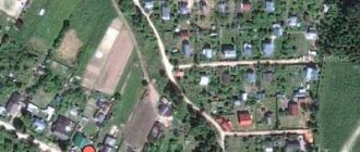
Satellite maps
As already written above, the public cadastral map we described is not unique and the only one available - there are other maps of a similar format on the Internet. One of these is located at this link.
This service is also provided by Rosreestr. The difference between this map and the classic one is that it is possible to switch to Yandex, Google and 2GIS maps, as well as a satellite view, which makes the search for free storage even more comfortable.
The interface of this card is slightly different from the previous one, but in general there are no fundamental differences.
It is also possible to include a thematic map on which occupied and vacant plots will be colored in different colors .
The ability to send a request to the Unified State Register is also present here. By clicking on the selected area, a window with information will appear, and at the bottom there will be a “View available documents” button.
By clicking on it, you will have the opportunity to order information from the Unified State Register and the cost of the service will be indicated.
Read more about satellite maps and the possibility of obtaining photos of a site from a satellite in the feature article.
By what indicators can you find
To find a plot of land on a satellite map, you need to know a number of characteristics by which you should search for it:
- The land plot must be entered into the Rosreestr database. But even this does not guarantee that absolutely all data about it will be displayed on the map;
- All registration work must be carried out for the site, including land surveying, drawing up a cadastral plan, obtaining a cadastral number and passport.
When searching, you should pay attention to the following criteria :
- Regional cadastral boundaries;
- District or municipal boundaries - they become visible when approaching;
- The boundaries of a specific land plot are visible when zoomed in;
- Pay attention to the color with which a specific area is highlighted on the map - it is an indicator of the form of ownership of the property. Pink indicates areas that are privately owned, and purple indicates municipal and administrative property.
- The area that you noticed by clicking on it is highlighted in green;
- Plots whose form of ownership is not defined are simply marked with red borders, without color shading.
Price
Map search itself , but in the end it will still cost you a pretty penny. And the size of this “penny” depends on the following factors:
- Even if you find the land you need on your own, which is also vacant, drawing up a cadastral plan for it will cost money. This service costs from 8,000 rubles and above .
- Most likely, you will have to request an extract from the Unified State Register of Real Estate. You can see the cost of this service in the photo above. And since you need to make requests for each site separately, and you will have to request it, perhaps, more than once or twice, this can cost you a very significant amount.
Information provided directly by the public cadastral map, without requests for an extract, is free .
Procedure
Land surveying consists of several stages. First, the customer and the contractor enter into an agreement. It is preceded by the owner’s choice of a reliable organization of cadastral engineers.
See more details here.
Documentation
The responsibilities of a cadastral engineer include not only geodetic work, but also document processing. He lists to the owner what documents are needed to determine the boundaries.
You must submit copies of the following documents
- identification;
- document on registration of property rights (Certificate or extract);
- title document;
- previous survey (if any);
- court decision (if boundaries are disputed).
During the land surveying procedure, other documents may be required.
Coordination of boundaries with neighbors
Coordination with neighbors is a very important stage in land surveying. If you approach this issue wisely, you can quickly go through all stages of land surveying. Otherwise, because of 10-20 cm, you can spend a long time sorting it out, spending time and money on legal and court costs. So first you need to decide what exactly you need.
When relations with neighbors are friendly, the issue of boundaries must be resolved through negotiations. That is, first agree, and then invite them with their passports to sign the agreement document, which is prepared by the cadastral engineer. Thus, all necessary formalities will be observed.
If the plots in the neighborhood are abandoned, then you need to find out from the SNT board or the cadastral chamber who the neighbors are on the plots adjacent to yours. Sometimes this work is undertaken by a cadastral engineer.
A notice of the upcoming arrival of a cadastral engineer must be sent to the indicated addresses. He must explain where the border will be and offer to sign the document.
It is better not to sign the approval act without an explanation from the cadastral engineer. Most often, the owner of a neighboring plot does not understand what data he is signing. When signing the approval act, the following must be present: the cadastral engineer, the land survey customer and the neighbors on the site.
Drawing up a boundary plan
The cadastral engineer prepares the main document based on the results of the work - the boundary plan. It consists of 2 parts (text and graphic) and contains a detailed report on the measurements and coordinates of the site boundaries.
The boundary plan is submitted in 2 copies. One remains with the owner of the plot, the other is sent to the cadastral chamber to make data or changes.
Registration and payment of state fees
in electronic or paper form
The electronic version must necessarily contain the electronic signature of the cadastral engineer.
On paper, there must be a signature and seal.
The owner can independently submit the boundary plan to Rosreestr. It is more convenient to do this through the MFC.
To do this, you only need a passport and a boundary plan. Payment of state duty when entering data into the state cadastre is not provided.
The contracting company whose representative draws up the boundary plan for you may charge an additional fee for submitting documents. This will be payment for intermediary services, but not state duty.