The public cadastral map is the official electronic resource of the Rosreestr service, which contains all the USRN information about real estate objects. Users receive information in graphic and text modes. All data provided by the public cadastral map is current and freely available to everyone.
The public cadastral map is the official electronic resource of the Rosreestr service, which contains all the information about real estate.
Cadastral map - what is it?
The information posted in this service is of interest to both citizens and legal entities. Using the Public Cadastral Map, you can obtain preliminary information about a real estate property, for example, about a land plot - visually see its boundaries in the cadastral quarter, its location relative to other land plots, and see adjacent land plots that are registered in the cadastral register. It will be useful to assess the attractiveness of a particular land plot by determining how far the plot is from the main road, whether it is convenient to travel to, whether it is included in zones with special conditions for the use of the territory, and also to find out its cadastral value. You can find information about a property by cadastral number, address or exact coordinates.
On the Public Cadastral Map it is convenient to use various thematic layers (section “Map Management” in the upper right corner). For example, if you need to find out how the land located next to the acquired plot should be used, so that there is no multi-storey building next to an individual house. To do this, you need to check the “land categories” box, and then the land categories will be shown in different colors. You can also set the topic “Cadastral value”; it divides the cadastral map into price zones of different colors - convenient and visual.
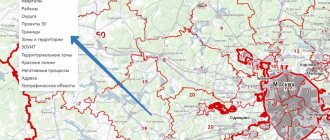
It also provides information on cadastral division, territorial zones, zones with special conditions for the use of territory, special economic zones, administrative-territorial division of the Russian Federation, forest districts and forest parks, the boundaries of the minimum distances from main gas pipelines, oil pipelines and petroleum products to buildings and structures.
If necessary, you can obtain data about the divisions of the territorial body of Rosreestr, which are authorized to carry out registration and registration actions in relation to a specific object on the map.
The information contained on the Public Cadastral Map is updated on an ongoing basis and is reliable, publicly available and free. However, information obtained using the Public Cadastral Map cannot be used as an official document - it serves only as reference information.
Purpose of the card
The public map of Rosreestr will help you quickly obtain information about an object of interest if you urgently need to check the property for legal purity. So, without an extract from the Unified State Register of Real Estate, which requires some time to obtain, the Public Card will quickly provide the following information:
- Cadastre districts into which the virtual map is divided. Basically, their borders coincide with the borders of administrative territorial units of the Russian Federation.
- Cadastre areas. For the most part, they coincide with the boundaries of settlements and regions, but there are some errors.
- Cadastre quarters. These parts of the map correspond to the boundaries of urban and rural settlements, gardens, forests, etc.
- Cadastre areas. These are the smallest parts that are an integral element of the cadastre. They delimit the land plots of shareholders of gardening partnerships, those located near private residential buildings. Some of them often indicate the location of the streets of a particular locality.
With its help, workers of various professions - lawyers, realtors, surveyors, through any of the most common browsers today, can obtain the information necessary for their professional activities in a completely free mode.
Often, a public cadastral map is in demand if there is a need to quickly clarify information about a certain property or land plot. Using the cadastral number assigned to a plot, you can determine its exact location, contours, and configuration. This also allows you to determine which district or district a certain land plot belongs to, the department of the cadastre service of the Russian Federation. In addition, it is used for land surveying of real estate.
Is it possible to find out the purpose of the land plot?
The purpose of a land plot must be determined when the user needs knowledge about the type of property or territory. The steps are simple:
- First you need to search using the cadastral number or by entering the address. All relevant information will appear on the search bar;
- Next, tap on “More details”. This line contains information about what kind of land it is, what types it has, and so on.
Working with a cadastral map
To obtain information on the cadastral number of a land plot on a public cadastral map, you must go to the website of the public cadastral map.
For ease of use of the map and changing the overview of the object, it is possible to move the map in a given direction and zoom
After logging in, a geographic map of Russia opens, on which you can see a vertical panel with map tools on the left, indicated by different symbolic signs (buttons), and in the lower right corner there is a map scale regulator. For ease of use of the map and changing the overview of the object, it is possible to move the map in a given direction. To do this, you need to move the mouse cursor over the map area and, holding down the left mouse button, move the map in the desired direction. Changing the map scale is done using the scale slider.
Tools
Map tools are the main “pilots” in obtaining information about a land plot. Using the public cadastral map tools listed on the toolbar. are:
- search
- objects at a point
- card management
- drawing
- measurements
- favorites
- card printing
- background information
- Feedback.
Using map tools allows you to use not only the visible external functions of the map, but also enter its layers and underlays, open numerous tabs and use a huge range of possibilities. Below you can watch a detailed video on how to use the public cadastral map.
Saving the information received and requesting expanded information from the Rosreestr website
To save the information received, you must follow these instructions:
- Add the result that the search engine provided to your “favorites” - click on the star located opposite the line with the result. You can add one object to this list, or several, or all. You can also remove the star from the document and remove it from your favorites list.
- Save the list. By clicking on the button with the image of loading or unloading file information, you can save the search results. The file format that will be saved on the PC is “csv”. Thus, you can not only save information, but also enter your list into the system.
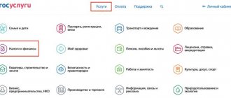
In order to obtain other information, you will need to contact the state cadastre service in person, or go to the online website of Rosreestr , where you select the name of the service that you need.
We hope that our recommendations for using the online cadastral map service of Russia will be useful to you. Now, with the advent and development of Internet technologies, it is much easier to find out information.
Cadastral number - what is it?
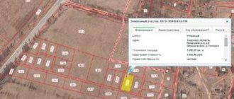
This is a set of numbers that define a specific block, area or area. Determining the cadastral number by referring to the address is quite easy. To do this, you need to find the desired area on the map. For each of the objects on the cadastral map the following information is available:
- exact area;
- address;
- price;
- status;
- characteristic;
- date of registration;
- type of ownership.
If you use the public map of Rosreestr, you can find the right property much faster and easier. All boundaries and adjacent areas are indicated here, which are also included in the register. The desired area can be carefully examined on a digital topographic map and on a satellite image.
For each of the objects on the cadastral map the following information is available: exact area; address; price; status; characteristic; date of registration; type of ownership.
Using a cadastral map, you can check the cadastral number of the desired object by address. The map will also be an excellent assistant if you need to determine the cost of a plot by address. To do this, you need to find this area, and the necessary information will become available.
Share map link
It must be indicated with colons and contain 4 groups of numbers. For example, 77:08:0009005:8 Print map
The map shows only areas for which land surveying has been done (that is, the exact coordinates of the corners have been measured).
By clicking on a section of the official map, you will find out the cadastral number of the object, area, purpose, year of construction (for the house) and can go to view all available electronic extracts from the Unified State Register of Real Estate.
technical errors of the cadastral map.
The map shows only areas for which land surveying has been done (that is, the exact coordinates of the corners have been measured).
In addition, using a public map you can find any information related to the administrative division of Russia and find out where the selected land plot is located. Through the service you can find the branch of RosReestr to which it belongs.
The meaning of the cadastral map
A public cadastral map within the Internet portal of public services provides many advantages both for consumers of public services in the field of real estate and for Rosreestr, which provides them, for example:
- the number of visits by citizens and business representatives to cadastral offices is reduced, queues are reduced;
- the reliability of State Tax Committee information increases and, accordingly, the number of requests to it increases;
- time and cost costs for obtaining documents and information are reduced and, in general, the quality of public services is improved.
Since the launch of the Internet portal of public services of Rosreestr and the Public Cadastral Map, more than 6 million requests to them have been registered.
Since the launch of the Internet portal of public services of Rosreestr and the Public Cadastral Map, more than 6 million requests to them have been registered.
It is important to note that the publication of public cadastral maps is only the first stage in the development of the Application. In the future, it is also planned to publish duty cadastral maps, cadastral maps of municipalities and constituent entities of the Russian Federation, thematic maps by land categories, types of use, status and cadastral value. The development of the Application in these directions entails the connection of new categories of users, including large companies, government bodies, executive authorities of constituent entities of the Russian Federation and local governments.
Is it possible to print a document via PKK?
Following the above instructions for receiving the CP, the citizen receives the document by email in ZIP format - an archive that contains one or more XML documents. In order to print the plan, you need to download it, and then:
- click the “browse” button when opening the archive;
- select source file;
- press the “print” button;
- the page will refresh and a printable document will open;
- The document can be printed by clicking on the printer icon, or saved by clicking the “file” button and then “save document”.
You can also print the desired area on the map - to do this, you can select the required area on the Google map and take a screenshot of the screen:
- select the area and press the Print Screen button on the keyboard;
- transfer the resulting image to any program, for example, Paint;
- save the image (“file” - “save as...”);
- print the file.
Thus, having received an extract containing the CP by email, the user can issue it in traditional paper form - to do this, the file just needs to be printed.
The cadastral number of the land plot is the main identifier of any real estate, and the registration document contains basic information about it. Previously, citizens had to waste time going to RosReestr offices and standing in long lines waiting to receive the required document.
With the advent of the public cadastral map, anyone can obtain the necessary data on real estate without leaving home. To view the land plot plan, knowing its unique cadastral number, you need to use the online public map service. On the website you can pay the fee to receive the document, and the extract received by email can be downloaded and printed.